
-
 5611 Hits
-
 80.49% Score
-
 12 Votes
|
|
Route |
|---|---|
|
|
45.47891°N / 112.96143°W |
|
|
Half a day |
|
|
Maintained Trail, Cross Country, Scrambling |
|
|
Overview
This route is an alternative to the route from Gorge Lakes outlined in the main page. Cedron Jones features this route in his excellent book Peakbagging Montana, and having used this I think it might make a better alternative than heading straight up from Gorge Lake: a little less loose scree and rock. The route does require some cross country route-finding in the woods between the maintained trail and the NE Ramp though, so my purpose in putting this up is to outline a good way to access the ramp.This is a somewhat vague guideline to the route, as I do not have GPS, waypoints, etc. My goal is to make you aware of the a pleasant, easy way to access the ramp with minimal bushwhacking and cliffing out, but you'll still have to do the work on your own, before and after hitting the trail; study your topo maps, Google Earth, etc. Though I didn't have a GPS myself I'd probably still recommend carrying one, or at the least having common sense and a decent sense of direction in the wild.
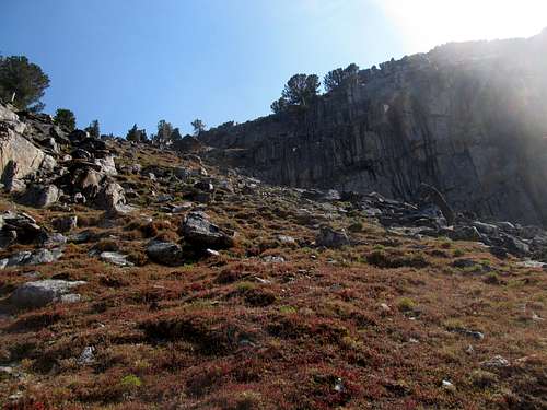
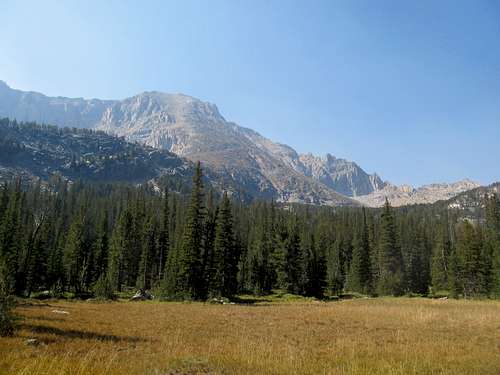 NE Ramp from the Meadows
 |
|---|
Getting There
Follow the instructions on the main page. I'll add that you can reach the Gorge Lakes turnoff with a passenger car, though I wouldn't necessarily recommend it. The road is very rocky. I wouldn't push it any further past it, but if you can inch your passenger car up I'd recommend parking at the turnoff and walking the extra mile to the 4WD trailhead.Route Description
4WD: 10 miles RT. Approximately 3,800 ft. Gain2WD: 12 miles RT. The 4WD road to walk will descend about 100 ft then ascend 150-200 ft to the 4WD trailhead.
Follow the New Gorge Trail as it winds nicely through the woods for around 3 miles from the 4WD trailhead. At approximately a point btw 8,700-8,750 ft. or so look for the "Old" Trail heading towards Gorge Lake. This is an unmarked trail branching left, but still should be visible at from the junction. There are carved blazes along the trees that follow this faint trail through the woods, and there is a large boulder on the left of the Old Trail south of the junction. Per the guidebook you should be able to hear the creek nearby (to your left) at this point. I forget if I did or not; I probably did hear it. If the New (Maintained) Gorge Trail starts to swing back right (northwest) and starts to gain elevation as it ascends towards the northern of the Gorge Lakes, then you've gone too far.
Follow the faintly marked "Old" trail to the meadows about 8,750 ft. You will have a great view of Tweedy and the NE Ramp, your objective, from this point. The Old Trail winds along the right (northern) side of these meadows. Follow it past the meadows.
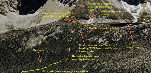 Outline of Route from Meadows to NE Ramp
 |
|---|
The "Old Trail" will continue to follow the stream on your left, eventually becoming fainter as it heads up through brush and trees towards South Gorge Lake. To access the shortcut to the NE Ramp, cut left and follow the stream for a bit past the meadows as you walk up through the woods, then cross it (should be an easy jump over) and cut southwest through open woods ascending gradually. You should reach a gentle, awning green gully ascending in a WSW direction. This is what I call the "First Ramp", and it has some large granite slabs at its bottom. Follow this beautiful and pleasant little gully to a small saddle. There will be some cool looking granite cliffs on your left as you ascend the "First Ramp" here, and from the saddle you can look directly down and to the west at the Southern of the two Gorge Lakes. You can cut right from this point and sidehill up the the talus to gain the NE Ramp, but a MUCH easier option would be to take a sharp left and ascend ESE up what I call the "Entrance Ramp" or Gully. Ascend this grassy gully for less than 200 ft to the lower shoulder/base of the main NE Ramp.
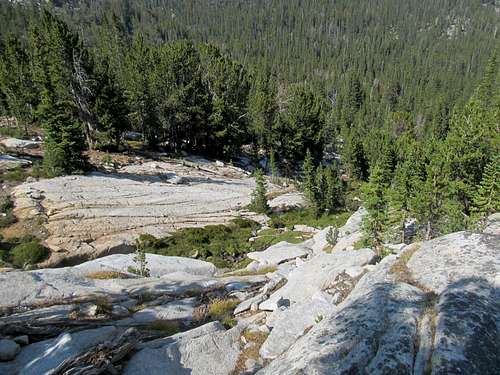 looking down towards base of the "First Ramp"
 | 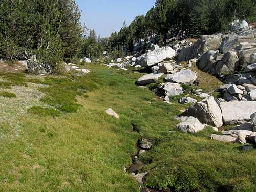 looking down the "First Ramp" near its top
 |
|---|---|
 Take a left and ascend the "Entrance Ramp" seen here
 | 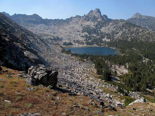 looking down "Entrance Ramp" at Gorge Lake. Take a sharp right on descent for the "1st Ramp", and vice versa
 |
Take a right and ascend the NE Ramp itself for about 2,000 feet to the summit ridge. The lower reaches are grassy, then eventually the terrain gets overtaken by boulders. Nothing should really exceed hard class 2, but it is very steep terrain, and these are big boulders with large gaps between them. If you find yourself in something you're uncomfortable with, try to go around it. The center of the NE Ramp has smaller boulders but more scree, especially up top. The right side of it has the big boulders. Watch out for the cliffs on the extreme left!
 Base of NE Ramp
 |  Looking down lower NE Ramp
 |  Looking down lower/mid NE Ramp
 |  Up NE Ramp Boulders
 |
|---|---|---|---|
 Up NE Ramp Boulders
 |  NE Ramp near the top
 |  Looking down Upper reaches of NE Ramp
 |  Scree atop the NE Ramp
 |
Once you're on the summit ridge take a right (west) and walk up and over some small summits to the top of Tweedy.
Try to retrace your route on your descent via the Entrance Ramp and the First Ramp. At the bottom of the first ramp cut northeast. Cross the creek, continue in a similar direction and refind the old trail before or at the meadows.
Essential Gear
I didn't use a climbing helmet, and this probably isn't a route that would require it in 95% of situations. However, it never hurts to be safe. Otherwise, just a sturdy pair of boots in the summer. Early summer the ramp may hold some snow, so adjust accordingly. Make sure you have a good weather window, as the top 2000 ft of this route are quite exposed to the elementsExternal Links
In addition to Cedron's guidebook I used the route outlined in the main page as well as these two excellent TR's from COHP.org as beta. I think the main difference between my route and their route is the use of the Entrance Ramp as a way to avoid the cliffs.COHP Link 1
COHP Link 2