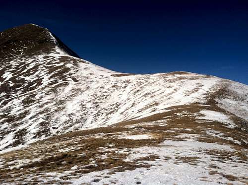
Final sub-ridge to the summit push. Note the steep loose rocks on the final ridge (top left)
Mt. Tukuhnikivatz 11/8/14
Approach/Access
My wife and I started the day at one of the great cafes in Moab to get breakfast and some sandwiches for lunch. Some locals mentioned that the La Sal Pass road coming from the west was two hours of 4WD low so we decided to approach from the east through La Sal, UT. This turned out to be fantastic advise since the road was smooth and well maintained all the way up (see "Getting There" on the main page). When we came into town three days before the hike we could see snow above tree line on all the La Sal's so we were ready for hitting snow on the road. The road started dry and slowly hit more and more snow in the shaded spots in beautiful aspen groves. When we got to the Beaver Lake turnoff about 0.3 mi before the pass the snow was 4-6 inches deep, icy and rutted. We decided to push on since we had AWD and new tires. We did reach the pass, but when trying to park realized we could easily get stuck and it looked as though average traffic was 2-3 cars in as many days. After some wheel spinning and pushing we made it back to the Beaver Lake turnout and parked. It was later than when we wanted to start (11am), but we set our turn around time at 2pm and set out.
The Climb
We walked back up the road for about 0.4 mi and turned right up the feint 4WD road with a sign that read 4725. With 2-4 inches of snow we followed this road for about 0.7mi then came to small clearing and crossed a large log, then broke left (NW) up a small hillside to top out at 10,400ft and cross an open meadow still heading NW and met up with a trail that came from the direction of the pass. Across this meadow snow cover varied from dusted grass to 8 inch drifts this was a theme throughout the hike. Still heading NW we came to the base of a steep SE facing slope free of snow. Since the trail entered the trees to hikers left and got lost in the snow we switch backed up the steep grassy slop to the ridge line rediscovering the trail on the ridge line at about 11,250ft.
We followed the trail through clusters of dwarf pines and shallow snow drifts almost due North to a high point at 11,800ft where we finally got a good view of the final ridge line and summit. It was at this point we realized that the summit was made up of steep loose rock and snow drifts that followed the ridge line. We decided to press on since we were still an hour before our turn around time. We made the final ridge line at 11,975ft and were rewarded with a beautiful view of Mt. Peale, South Mountain and the rest of the La Sal's to the North and South and great views of Arches and the res of the Moab Valley to the NW and SW. At this point we followed the ridge line west through increasingly steep, hard windblown snow and loose rocks. This section (and the trip as a whole) was manageable in good hiking boots and trekking poles, but microspikes were arguably of use throughout. My wife used them and I didn't and we both did fine.
About 75 yards along the ridge the slope increased and approached 45 degrees with very unstable loose rock and out progress slowed significantly. We switch backed to the hikers right of the steepest section and found ourselves over the fairly exposed North side of the ridge, I would not recommend this route. On some parts of this ridge we were glad to switch over to the steep snow drifts and kick steps since the snow stabilized the rocks somewhat. We reached the summit 15 minutes after our turn around time of 2pm ate a small snack, snapped some photos and headed down loose rock this time staying to the South of the steep section. It was not much more stable but avoided the exposure of the North. We retraced our steps and made it back to the car around 4:30 with some light still left and made it back down the La Sal Pass Rd. without incident.
By the numbers: 5.0 miles round trip, 2,478 ft elevation gain, 5h 13min total time (we are getting into shape and a bit slow and the lose rock sections didn't help)
This is my first SummitPost Trip Report so please provide comments and suggestions. I am reading Freedom of the Hills and honing my baby mountaineering skills on climbs like this one so please let me know what you think.


Comments
Post a Comment