Climbing Mt. Olympus - 1
Four Part Series - Part 1
The Olympics
The Olympic Range lies a scant 30 miles from Seattle on the Olympic Peninsula, a huge national park that is 95% wilderness and through which no road passes. In the spring when the sky is clear the gleaming white peaks of its mountains can be seen across the sound. However even in today's modern era of rapid transportation getting to them is an undertaking in time, and thats just to the east side that faces Seattle. I once did a
thru hike in the Olympics and making our drop off point and transferring to our start took 6 hours from Seattle, 3 hours of which involved me huddled in my sleeping bag in the back of a Toyota pickup. Mt Olympus at 7969 feet is the highest mountain in the range and is on the western side of the Olympic Peninsula, accessed up long and deep rain forest valleys, our destination to climb. Despite its relatively short height, the prominence of its peaks traps moisture blowing off the pacific and it is heavily glaciated at a much lower elevation than the Cascades that sit east of Seattle.
Imagine now how inaccessible the mountains must have seemed to the first settlers of the Puget Sound. The interior of the peninsula remained largely un-penetrated and in the modern age called out to be conquered, to be explored and made known. The Seattle Press, partially as a marketing feat to sell papers, sponsored what became known as the
Press Expedition. They started at the northern edge of the peninsula and made their way up the Elhwa River, starting in 1889 (Feb/March) pulling canoes up snow swollen river banks, transferring several loads of 50 lb of gear that included iron dutch ovens. Eventually over 50 miles and 5 months later they emerged at Lake Quinault having traversed the interior and made their way across the range.
Mt. Olympus remained unclimbed, at least according to the way modern man tracks and records events. In early 1900s mountaineering groups were popular,
The Alpine Club of London, the
Sierra Club in California by John Muir and associates, gradually it become more known for its political environmentalism than its outings, the
Mazamas out of Portland and The
Mountaineers based in Seattle founded by Ashael Curtis and Henry Landes. They set out for their first expedition to climb Mt. Olympus in 1907, during which 65 members made a group climb.
Signing up and Preparing
When I saw the advertisement in
Backpacker Magazine for
Summit for Someone the combination of an opportunity for a guided climb of a mountain and the chance to help out inner city kids get into the outdoors was an instant appeal. My first thought was honestly to sign up for Rainier, however by the time I attempted registering on the
Summit for Someone site Rainier trips were full and so I signed up for Olympus. Then began the work of raising funds to meet the pledge goal, and thanks to the generous contributions of many people I was quickly able to meet that.
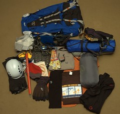
Finally the long wait through the winter for the
gear to arrive and then the training to gain experience and be in shape :
Guye Peak,
Mt. Adams and lots and lots of hiking like
Timpanogos. Then came July, which is when the rain is typically supposed to stop in Seattle, but not this July. We had rain, lots of it. Gray skies and thunderclouds. As we got within two weeks of the climb, the mostly cloudy and showers forecasts were not looking too good. The week before the climb it was pouring rain in the Olympics, but the forecast showed clearing on our days. I talked to Craig Von Hoy (our guide) on the weekend before we went and he told tales of buckets of rain for the prior group and they turned around on the glacier and didn't even attempt the summit because it was raining so hard. I packed everything up and prayed for sunshine. :)
Day 1 (and a half)
We had to be to Hoh Visitor Center by 10 am on Thursday. Since its a 5 hour drive for me, and even more for Seth, we decided to leave on Wednesday evening. I drove out to Olympia and met Seth and Jeff Roberts, who had drove up from Portland. They grabbed a bite to eat at the 2 Mile House Pub and Eatery, and then we dropped off my car at the Mormon church on Overhulse road and started the long drive in the mini-van for the coast. Around midnight we were getting tired and we stopped in
Aberdeen, a logging town where Kurt Cobain grew up and which now has the phrase
Come as You Are beneath there city sign. We grabbed a room at
Aberdeen's Finest Olympic Inn, which for a Wednesday night was 2 rooms shy of being full up and the clerk had no idea why. I crashed on the floor while Seth and Jeff took a bed and we woke at 6 the next morning to get started. We stopped at Denny's for some grub (actually not too bad, despite my vow to never return) and then headed for
Humptulips and beyond. We were still a bit early and so we stopped off at Ruby Beach for quick stroll.
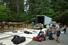
We pulled up at the Hoh Visitor Center parking lot at 9:55 am right on time. The trip was guided by
Craig Von Hoy's Go Trek & Expeditions. Craig has over 30 years experience guiding, has summited Rainier 357 times, and Olympus over 40. He knows how to climb Olympus and given the super long approach (over 18 miles) a key to this is
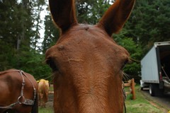
pack animals. Craig hired a pack team, Glenn and Al, and their 6 mules to haul our gear the first 15 miles to Elk Lake. So after the rest of the crew pulled up and we did introductions all around, for the next two hours we sorted gear, moving all the heavy stuff to the
mantie's for the mules and helping organize the group gear. At noon, one climber (Nathaniel Cogdil) hadn't shown up (we found out later he broke his foot) and we paused for the requisite
before group photo and then headed off down the trail for Lewis Meadows 10.5 miles away.
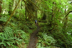
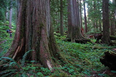
The Hoh River runs 50 miles from the Hoh Glacier on the east side of Mt Olympus, over the eons the Hoh River has cut a deep valley with a meandering floor in which 240 inches of rain falls annually and the world's largest temperate rain forest grows. The mild climate combined with rain leads to massive growth, both in terms of the amount of biomass produced and as huge trees. The trail parallels the river and meanders through a verdant green landscape that overwhelms with life. After a short break at
Happpy 4 Shelter, we arrived at Lewis Meadows around 4 pm.
The mules had already arrived and we promptly set up a
luxuriuos camp for backpacking and then headed down to the river to rest, relax and refill our water bottles. I was hot and tired and
took a dip in the river to clean up, the water was freezing (as it came from glacier melt) but was refreshing in a chilly sort of way non-the-less. Jeff was bushed and found a nice place to take a
quiet nap. After waking him we made our way back to camp to for an amazing
salmon burrito dinner and then a round table dinner discussion where we did lengthier introductions and went over the itinerary. Bushed and tired from a long day on the trail we went to sleep in preparation for the long day tomorrow hiking up to high camp on the glacier.
Stats : 10.5 miles - 840ft asc - 370 dec - 5 hr, 7 min
Climbing Mt. Olympus - 2
Four Part Series - Part 2
Day 2
Our day began with a 6 am wakeup call from Craig, we woke and had an awesome set of breakfast burritos. We broke down camp and separated out the heavy gear we'd need for high camp, all of the large tents, chairs and large gear stayed at Lewis Meadows. The mules once again carried the gear, this time

though they would only accompany us half way up to Elk Lake, beyond Elk Lake the trail
gets narrow and mules can't pass. The section of the trail just east of Lewis Meadows continues with the series of huge trees, these are quickly left behind as the trail begins to climb towards Elk Lake. Just prior to the lake the trail turns south and crosses the Hoh River, which at this point cuts a deep narrow gorge through the rock. The High Hoh bridge crosses this 140+ foot chasm.
At Elk Lake we rested in the trees above the lake (we never ventured down to the lake itself) for a bit waiting for
Glenn,
Al and the
mules to catch us. Who should come walking down the trail but one of my Flickr contacts,
Chris :
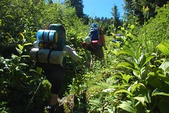
cpkpdx, we'd run across each other posting photos of mountaineering. We'd discovered we were both going to be heading up to Olympus around the same time, he'd be coming out at around the time I was going up. It was great meeting him in person, glad to hear he'd summited and I felt bad he had a 15 mile full pack journey ahead of him back to the car. After Chris left the mules arrived and we crammed our packs full of gear and started the 5 mile hike up to Glacier Meadows. The trail wound its way through some
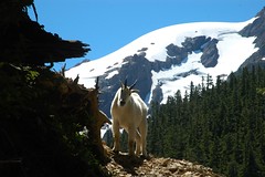
avalanche chutes where the trail got very narrow. As we came up the trail to a bend around one of the rocky chutes a mountain goat was waiting for us. He let me walk within 5 feet of him before he scrambled up the hillside a bit and we passed by. By this point, one of our guides, Meaghan turned back as she had been throwing up several times and was feeling quite ill. Soon we arrived at Glacier Meadows which had a
yurt for the rangers and we stopped for a bit of rest and some water. Loading up we left the trees behind as we began to hike into the high meadow and alpine zone where the grass was green and the flowers were out. We followed a small creek up a drainage toward the top of the ridge. Along this section of the trail I was bonking pretty hard, it was hot, I was tired and I hadn't eaten enough. I had packed too light on food, opting to leave too much of my lunch snacks behind at Lewis Meadows. I slowed down a bit and walked towards the back of the pack with Craig.
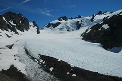
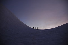
At last we arrived at the top of the ridge which was the top of a huge moraine that overlooked the blue glacier below and Mt. Olympus and the snow dome rising up above us. It was an overwhelming glorious sight. For the entire 18 mile approach you don't really ever get any good views of the mountain until the very end and you come up over the ridge and then everything is in view. We all
sat down and gazed at the spectacle before us. Everyone pulled out their cameras, they way you always do the first time you see a spectacular scene. We changed into long pants out of shorts, put on gaiters and a long sleeve shirt and
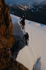
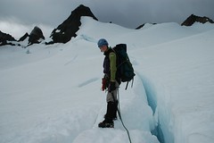
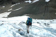
made our way down the moraine across the snow field to the edge of the blue glacier. Here we stopped and put on our harness,

crampons and light gloves and split into two rope teams. Alaina, myself, Seth and Jeff on one rope and Craig, Sue, Steve, Karl and Jim. We'd maintain these positions for the next 24 hours through the next day. Off we set across the glacier, you can follow our
route on this google map. Its an amazing landscape where ancient blue ice crunches beneath your crampons, interspersed with snow. I took a shot with the camera and Alaina snapped at me to stop taking photos and concentrate on walking where she walked. I asked her to explain her thought process as we crossed. She explained how snow could be covering crevasses, and that old ice was the safest. Another thing we had to watch out for was melting holes in the ice and snow that could appear shallow or firm but be an icy dip. She also explained how crevasses form, in glacier fields the convex surface cracks and splits, on snow fields higher up the same convex surface does the same but with height playing factors as snow lower down pulls away from snow higher up. The majority of the crevasses we walked around or crossed were very small, maybe 6 inches wide. There were some larger ones but we avoided those, most of the really big crevasses were higher up on the snow fields.
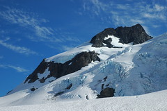

Once safely across the glacier we stopped for a break and removed the ropes and crampons and refilled our water. We stared in awe at the gnarled ice fields above the glacier. A maw of cracks they were beautiful to behold. We then turned right or north and started climbing the snow ridge and rocks towards our high camp. A short while later as the long sun shone we pulled

into camp just before 5 pm, 11 hours on the trail, 9.2 miles and 5340 feet since Lewis Meadows. Seth, Jeff and myself opted to camp on the snow and cleared a flat place to
pitch our tent. While Craig and Alaina
cooked up some dinner, I tried to get a good close up photo of everyone in the group, but I missed Jim who was lying down resting. Diner was ramen, that cheap kind you haven't eaten since college, but it tasted so very very good. I had a steaming overflowing cup and two chocolate puddings.

By this time Sue was exhausted, I think maybe more mentally than physically and she decided she'd not be accompanying us on the summit attempt the following morning. Craig gave us a few minutes rest and then had everyone meet Alaina on the snow above camp and she went over
self arrest with an ice ax 
in the event of a fall and Sue took a photo or two for me with my camera.
Then a quick flurry of last minute packing and arranging for the
early morning summit day, and we lay down in our tents. It was 8pm and within seconds we were all asleep, tired again from a long day and attempting to get in as much sleep before the 1 am wake up call.
Stats : 9.2 miles - 5340ft asc - 350 dec - 11 hr
Climbing Mt. Olympus - 3
Four Part Series - Part 3
Day 3 - Summit Day
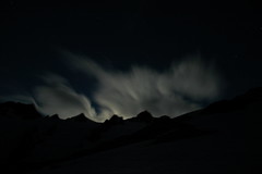
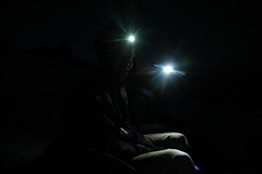
At 1:10 am Craig's voice boomed across the snow : "Time to wake up guys". The thump of adrenalin hits your veins in anticipation; throw on the contacts, clothes, harness, boots, helmet, gaiters and crampons. Stumble outside and
behold the mountain all aglow from the moon with high clouds wisping overhead. I packed my mono-pod for summit shots, and crammed it into the snow for a few shots while I ate my 2 packs of oatmeal mixed in with hot-chocolate. The anticipation of the start dulls any sense of sleep or tiredness. We rope up, same order as before : Alaina leading, then me, then Seth and Jeff brings up the rear. Craig starts off first up the snow dome, leading Steve, Karl and Jim and we follow. They take a nice rest step pace : kick front leg and lock, taking off weight from back leg then left back leg and kick. Lather, rinse and repeat. One step at a time make our way up the snow dome. Its not a race and I am not even breathing hard, so trying to be helpful in the dark plodding along I start telling a story from the book
Worst Journey in the World about Scott's men camping on the ice with Russian horses and how they woke in the night to the sound of breaking ice and open water

and were harried by Killer Whales.... (read the book) and Craig yelled back down : "Hey guys lets keep quiet and listen to the sound of the morning wind. If you guys have enough air to talk perhaps I am not going fast enough". In other words shut up. :) I mutter inside my head a bit hurt, but turn my attention back to climbing, which was exactly Craig's point : stay focused on the task at hand. He warned us again to be careful as we came upon our first turn on the slope where we'd have to step across the rope as we changed directions. Seth slipped and his right crampon sliced the gaiter, pant and calf on his left leg. About 3/4 inch wide and deep enough to have some fatty stuff poking out. Alaina pulled out her first aid kit, butterflied it, gauzed it and wrapped it. Seth said it felt fine and we carried on. Late Craig said he was worried he was going to have to send Seth back to camp, I replied that I think you'd have had to saw Seth's foot off to keep him from reaching the summit that day.
We carried on up the snow dome and then with the summit directly in front of us which has a huge
bergschrund blocking a more direct ascent, so we turned to the left (east) heading for a notch in
the Five Finger Ridge. Here we came to a very steep 20 foot slope. Alaina kicked steps up the slope and we all followed. Still pitch black we crossed over a gnarly looking snow bridge across two crevasses and made our way along a snow field leading around the backside of the summit. Karl asked Craig if we were stopping anytime soon as he was having cramps and was going to have to use the bathroom! Uggh, talk about not the time; usually they just furrow out the rope to the end and you have no privacy, but Karl convinced Craig to let him go down the slope a bit, we all turned of our lights for a bit of privacy and waited.
Blue bag in hand, Karl said he felt better and we carried on. We stop to remove our crampons and cross a rocky ridge on the backside of the summit, just minor scrambling without any exposure. We've now come full circle to the ridge below, the sky is beginning to lighten as we walk up the windswept and icy bowl of crystal pass that sits between the west peak and a small unnamed rocky peak. Once more on with the crampons we kick up the very steep slope of the last snow field below the haystack of the west peak.
Now its a matter of route finding for Craig and Alaina while the
rest of the two rope teams sit on the slope and
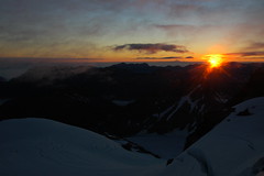
wait. What a fortuitous set of circumstances, as we sit the dawn unfolds before us. The clouds in the sky takes on an
intense orange glow silhouetting Mt. Baker and then I yell as the sun cracks over a distant ridge and shines its orange glow across the peaks as we all
grin from the sheer joy of being up high with such a beautiful setting. Meanwhile Alaina and Craig have prepared a narrow snow ramp with steep sides onto the haystack. Protection is provided by a couple of
picket's along the way. As we cross the bridge, we leave our crampons and ice axes behind on the snow and start the scramble up the haystack.
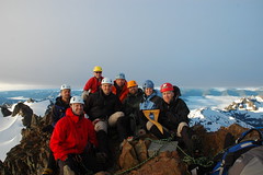
This scramble has a bit more exposure, as we walk along a crack and then climb up a
5.6 chimney which got my blood pounding. Then its a simple matter of scrambling up the ridge line to the summit! The views were astounding as the still early light played off the snowy peaks of nearby Mt. Tom and the north summit. Mt. Adams and Mt. St. Helens lay off on the distance as well. I cram my mono pod in between two large rocks and shimmying it with a small rock and we all pose on the top for the requisite summit photo. We spent 30 minutes on top, admiring the views, taking photos and taking it all in. What a sense of accomplishment, and what a great mountain.
Then the reverse begins, we down climb through the chimney and begin our descent. Its interesting to see in the light going down what we'd passed in the dark coming up, large crevasses looked bigger in the light and the snow dome is much better lit up. We made quick time step sliding down to the steep slope of the snow dome above our camp. Along the way I continue to take photos, and Craig took to calling our rope crew the Shutter Bug Team, as Seth has the same photo taking propensity, later this moniker was shortened to the Bug Team and then the B-Team. Arriving at the snow dome, we all really wanted to
glissade down, so we traversed over a bit so as to not go sliding into oblivion and then while roped up each team slid down in succession and walked the few feet back to camp. Safe and sound, my body seemed to know that
NOW was the time to relieve bodily functions and I became a member of the blue bag club. (Its very important in the high alpine zones to minimize the impact of humans, thus all solid waste has to be bagged and removed) We broke camp, loaded up our packs and started descending through the rock and snow fields to the blue glacier.
Traveling back across the blue glacier was very hot, while a cool breeze blew high clouds across the mountains, the sun was still shining and the reflective sun across the ice was sweltering. I was sweating buckets as we made our way back across. With the two days of sun, there was even more water on the glacier and the slushy holes. Sadly our time on the snow and ice came to an end and we made our last bit of elevation gain back up to the top of the moraine where we changed out of long pants and shirts to shorts and sleeves and put all the glacier gear away. The heavy packs slung once more on our backs, we made for Elk Lake where we would reunite with the mules. I have never been more happy to see a 4 legged creature than those mules walking up the trail. Our packs lightened we quickly made the way back over the High Hoh bridge, around the chutes and to Lewis Meadows, 14 hours after starting that morning. Seth, Jeff and I wandered down to the river to wash off. I lay down in the river a couple of times and scrubbed the sweat and grime off. Seth not having a change of clothes stripped and bathed. I tried to convince Steve to get in, goading him about when he'd be back in such a setting, but he just enjoyed laying on the sand bar listening to his i-pod. Dinner that night couldn't come soon enough, we were starving. Finally ready, we piled in for mounds of pasta with cheesy sauce and sausage. Exhausted we trundled off to bed to catch up on sleep. Sadly my sleeping pad had been had been punctured at high camp while packing up and I had a very uncomfortable night ahead of me.
Stats : 13.4 miles - 3090 ascend - 7860 decent - 14 hr, 35 min


Comments
Post a Comment