
|
|
Mountain/Rock |
|---|---|
|
|
43.30218°N / 122.5378°W |
|
|
Douglas |
|
|
Trad Climbing, Sport Climbing |
|
|
Spring, Summer, Fall |
|
|
2000 ft / 610 m |
|
|
Overview
 Old Man & Old Woman
 Old Man
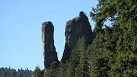 East Side, Photo by OldManRock
Located in the Upper North Umpqa River Valley just west of the Cascades crest, Old Man and Old Woman are two prominent rock spires that protrude from the valley slope a few hundred feet above the river. Since the two spires sit on a steep slope, their height (base to summit) depends of course on where you measure it. To get a sense of scale, I would estimate their height at about 300+ feet particularly when viewed from the east side. Though technically not mountains, the two are worthy climbing objectives as the easiest summit routes are 5.9 and 5.4R for Old Man and Old Woman, respectively. In his guidebook, Greg Orton describes the rock as being formed from "rhyo-dacitic intrusions". In practice this translates to "somewhat loose but overall not too bad". More on rock quality will be mentioned in the route description pages.
Note that the given summit elevation is a very rough estimate based on a USGS map as well as a glance at altimeter on the summit. The summit of Old Woman seems to be higher than that of Old Man. I wish to acknowledge Greg Orton for writing a great guidebook to rock climbing in SW Oregon as well as for providing route beta for The Old Man.
Getting There
 2003 (bridge repaired since)

 Old Man Summit
The formation is accessed via Oregon state highway 138. Take OR138 2.5 miles (not 1.5 miles as the book claims) east of Boulder Flats Campground (approx. 54 miles east of Roseburg, OR). Note that Old Man And Old Woman spires are visible from highway 138 (at or near mile marker 54). Turn left onto Medicine Creek Road (FS Road 4775). Take the first left onto FS Road 4775-011 (this is about 100 yards from OR138). Stay on road 4775-011 as it parallels highway 138 back westward. Soon, 4775-011 drops downhill and away from the highway. Pass the Pacific Power facilities and cross dam (Soda Springs Dam) to the north side of the North Umpqa River. Follow 4775-011 to its end (gated) approximately 2.5 miles from highway 138.
From the trailhead, hike past the gate following the Forest Service Road uphill. At the junction (approx. 5 minutes from TH), bear left and downhill towards the Boulder Creek bridge. Note that you're not following directions for Boulder Creek trail to the right. Once across the brige (mostly washed out as of May 1, 2004; bridge repaired per Kletterhund's beta 2008), stay on the trail for approximately 15 minutes (c. 0.5 miles) as it nears the North Umpqa and then follows it. You will then come to the small Eagle Creek (no bridge). Cross it. Once on the other side several options are possible.
The first option is to stay on the riverside trail for about 100 yards to the point just past the river gaging station high line cable crossing the N. Umpqa. You should see a faint climbers' trail heading right and uphill. Old Man and Old Woman are directly to your right a few hundred feet above. Follow the faint climbers' trails as they switchback up the hill to the southern base of Old Man (Old Woman lies higher up, or north of Old Man). The second option is to follow eagle creek uphill about 50-75 yards and pick up a more pronounced climbers' trail there. Again follow the switchbacks to reach the southern base of Old Man. Total approach time is about 20-25 minutes from trailhead.
Red Tape
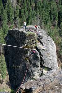
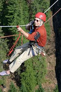
 Setting Up Tyrolean
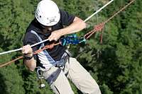
The North West Forest Pass is (I believe) required to park at the trailhead ($5/day or $30/year). No self issue box available.
When To Climb
 The Prize, 11c
The climbing season is dictated by when FS Road 4775-011 becomes melted out. However, it is likely that Pacific Power maintains at least some part of the road open year round to access their facilities. Regardless of this, the climb can be done year round provided you're willing to hike the extra distance to reach the trailhead (total distance from highway OR138 is approximately 2-2.5 miles). Although this of course depends on a given year, the earliest entry in the summit register atop of Old Man in 2004 was from early March (reporting great weather).
Camping

 Summit Register
The closest campground is the Boulder Flats Campground located on OR 138 2.5 miles west of the Medicine Creek Road junction. This is a NFS operated campground and is most likely subject to seasonal closures.
Mountain Conditions
The primary source for climb conditions and route beta is Greg Orton's website: http://www.climbsworegon.com/. Alternatively, the National Forest Service office in Glide, OR might be able to provide information on the conditions of the trailhead access road. Their number is: 541-496-3532.
External Links
- Climb Conditions and Other Info. This is a great website operated by the author of the listed guidebook to the area. Check out the page for new routes updates, current route beta (see the chatroom for instance), as well as seasonal closure information (nesting closures).
gorton - Aug 16, 2014 12:22 am - Hasn't voted
CorrectionA Northwest Pass is not required at any of the climbing areas in Western Oregon. Camping is free on National Forest and BLM Lands, except in improved Campgrounds (campgrounds with parking areas, tent space, and outhouse). Check on fire restrictions before building campfires, but usually camp stoves are OK.
rpc - Aug 16, 2014 1:09 am - Hasn't voted
Re: CorrectionHi Greg, any interest in taking over this page? Can't think of anyone better qualified. Love your guidebook(s). Cheers. Radek