Introduction
An introduction
Although the Scottish mountains are small by global, or even European standards, they pose a specific set of hazards, not commonly found in mountains of similar stature. An average of one-third to a half of all incidents requiring a mountain rescue call out in this country are attributed to weather, as well as poor planning and meteorological skills on the part of the people involved. In this article I'll try to explain the specifics of Scotland's mountain climatology and topography, and what effect this has on it's meteorology.
Outline of Scottish Climatic conditions
The Highlands of Scotland lie between 56° and 59° North latitude, roughly the same latitude as Juneau, Alaska or Churchill, Manitoba. This has two main effects on the weather, especially during the autumn, winter and early spring: First, from September until April, Scotland is just south of the Polar front, the boundary between the mid-latitude Ferrel Cell, and the Polar Cell. This is an important boundary, because it separates cold, dry airmasses, and mild to warm humid airmasses, ensuring that the right conditions are met for extratropical (baroclinic) cyclogenesis. Due to the fact that because of the Azores high the jetsream gets steered into a much higher latitude zone in the North Atlantic (50° to 65° North, as opposed to the 40° to 50° range in North America), as well as the abundance of relatively warm ocean water, which in turn warms the airmasses above it, due to the North Atlantic drift. These conditions make this region the ideal breeding ground for particularly strong extratropical cyclones, which can form faster in the North Atlantic than anywhere else in the world. To get an impression, during a January 11th, 1993 storm, pressure fell to 916Hpa. (27.05 inHg), equivalent to a strong Category 4 hurricane. Less than 36 hours earlier, the central pressure was 965Hpa (28.50 inHg)
![Jan 10, 1993 reanalysis]() January 10th, 1993 - click for larger image
January 10th, 1993 - click for larger image![Jan 11, 1993 reanalysis]() January 11th, 1993 - click for larger image
January 11th, 1993 - click for larger image
Second; because of Scotland's latitude, there is very little insolation during the months of November through February. At the winter solstice, the sun rises a mere 10.5° above the horizon in Glasgow and Edinburgh, 9.5° in Fort William, Aviemore and Aberdeen, 9° in Inverness, and 8°-8.5° in Thurso, Durness, Stornoway and Ullapool. Going up to the Northern Isles, this decreases even further to 7° for Orkney and 5.5°-6° for Shetland. To give an impression about how little this is, at 40° North, roughly the latitude of Rome, Madrid, Philadelphia, Chicago, Denver and Salt Lake City, it takes the sun about 40 minutes after sunrise to reach a height of 6°, and just over an hour to get to 10° in the sky. And these are the figures for December 21st...
Besides that this causes the length of day to be around 7 hours in Southern Scotland, and less than 6 in the far north.
In addition to low sun and short days, this also causes valley and ground fog to linger around for days at the time, until a front moves in and cleans the glens out. During the winter, the weak rays of the sun are simply not powerful enough to heat the lower atmosphere sufficiently for the dew points to rise and the fog to clear. And besides that, in many sheltered and deep glens the rays of the sun can't even reach the bottom as illustrated here below.
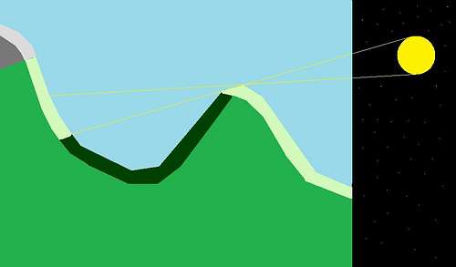
![A sheltered glen]() A deep east-west glen around the winter solstice - the dark green part does not receive insolation.
A deep east-west glen around the winter solstice - the dark green part does not receive insolation.
Topography
And this is where we get to the final subject of this introduction; the topography. Scotland is highly mountainous, and many of the larger peaks in the Highlands have an almost Alpine feel to them, much more so than other mountains 400-500 million year old, but the Highlands as we know them today really are a product of the last 2.6 million years. If it weren't for the glaciers cutting out most of the glens and lochs, the Highlands would more likely resemble a range of rounded hills, much like the Quachita Mountains in the United States, or the Erzgebirge in Germany, which are both of similar age, but have not seen major glaciations in geological recent times.
But because Scotland did see a lot of glacial erosion since the Late Pliocene, it is home to very interesting terrain.
After the glaciers left, the left us a miniature version of some of the greater ranges on this planet, in a nice 1:5 scale in all directions. Scotland has many small ranges and groups of mountains, which all affect the weather like it were 10,000' peaks. It may be a brisk 10C/50F with a 20mph@230 wind straight down Loch Linnhe at the Morrisons parking lot in Fort William, while at the same time it's calm with 15C/59F at the Achintee farm two miles south in Glen Nevis. And 4000' up at the Carn Dearg plateau it could just as well be around freezing with 50 mile/hour winds, close to zero visibility and complete white-out conditions. And 100 miles away in Edinburgh, students are drinking beer in the meadows while enjoying the sunshine and the 17C/62F weather...
Climatic averages
For a country where one can never be more than 30 miles from salt water, interior Scotland can show a surprising amount of continentality.
During periods of stable, calm, winter weather, it may get surprisingly cold in some sheltered, inland glens. Not so surprisingly, the two stations that tied each other for the cold record, Breamar and Altnaharra, are less than 20 miles away from each other as the crow flies. Both places have measured a low temperature of -27.2°C (-16.9°F) at least once.
Average January temperatures are in the range of 0-8°C (32-45°F), with night-time frost common above 300 metres. (1000') July temps are between 12 and 17°C. (54 to 63°F) Diurnal variation is usually around 4-7°C (7-11°F) and anything over 25°C (77°F) qualifies as a hot day. 30°C (86°F) or warmer has only occurred in the Central Belt, some southern glens and Strathspey. The highest recorded temperature in Scotland was 32.9°C (91.2°F) in Greycrook by Galashiels.
And as with any mountainous country in the Marine West Coast climate zone, it's eastern part is surprisingly dry. Inchkeith, a island in the Firth of Forth by Edinburgh, receives only 548 millimetres (21.6")of precipitation annually, and Inverness isn't much wetter with 624 millimetres (24.5") per year.
On the Western side, Scotland does live up to it's reputation. Kinlochewe receives 2277 millimetres (89.7"), Fort William around 2560 millimetres (101.2") and some west-facing slopes in Lochaber and Knoydart above 800 metres (2,500') receive up to 4400 millimetres (173.2") per year...
When it comes to windiness, the same east/west division is clearly visible. The Angus Glens and the greater Aberdeen area (more particularly, Banchory/Aboyne) are the least windy, with averages around 7 mph, while the Western Isles are the windiest, with averages in the 15-18 mph range.
Sunshine is sparse anywhere in Scotland. Saint Andrews, the sunniest place in Scotland gets a mere 1550 hours a year, the Northwestern Highlands on average less than 1200 hours.
![Bealach Aoidhdailean - Rapid clearing after a blizzard]() Bealach Aoidhdailean - Rapid clearing after a blizzard. March 13th, 2005. Blizzard lasted 25 minutes and dumped 7" of powder...
Bealach Aoidhdailean - Rapid clearing after a blizzard. March 13th, 2005. Blizzard lasted 25 minutes and dumped 7" of powder...A practical and all too common example;
This is a typical situation that gets a lot of people in trouble unfamiliar with the mountain.
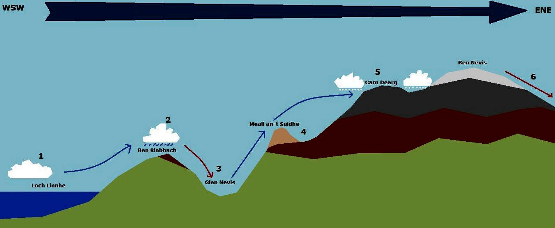
I've used Glen Nevis in this example because it's heavily visited, next to Scotland's tallest mountain, right on the west coast. Also, the topography of the surrounding area, complete with most common path of approach, as well as the usual direction where the wind is blowing from, makes it a prime example of how people may misjudge the weather situation, with a possibly disastrous outcome.
Typical weather pattern around Glen Nevis |
For this scenario, we'll use the following "base" settings; These are also the settings at point "
1" at the diagram.
- Wind; 240° at 20mph (sea level) 240° at 45mph (1200 metres/4,000')
- Temperature; 8°C/46°F at Loch Linnhe
- Dewpoint; 7°C/44°F at Loch Linnhe - RH: 93%
- Type of weather: "Nice" early spring day between two frontal systems. Occasional showers in the forecast.
Cloudbase is at around 150 metres, (500'), where the air temperature is at around 7°C (44°F), and the dew point around 6.6°C (43°F). Where this airmass starts interacting with Beinn Riabhach, as pointed out in point 2, it wants to rise above it. (air is lighter than granite) When it starts rising up the hill, the airmass needs to spend energy, which in this case is heat energy. It'll cool off along it's
dry adiabatic lapse rate, until it reaches it's dewpoint. This will occur at around 200 metres, with the temperature around 6.5°C, and the dewpoint at 6.5°C. Here is where the parcel of air becomes saturated. This is not enough. Our parcel needs to rise up to around 500 metres to clear the range, which will follow the
wet adiabatic lapse rate, because it needs to shed moisture. (Also known as rain.)
By the time our parcel gets to point
2, it has cooled off to 5.1°C (41°F) and so has the dewpoint.
Now we're going down to Achintee. (
3) Our parcel races off the hill with less moisture than it started with, picking up 4.9°C on it's way down.
Dewpoint picks up as well, and at the Ben Nevis Inn it's 10.0°C (50°F) with a dewpoint of 6.1°C (43°F)
People parking their car in the carpark will notice a temperature of 10°C with a RH of around 75%. On High street these figures were 8°C and 93% RH.
We start walking up the ponytrack. By the time the ponytrack turns left into the "valley" of the Red Burn and towards the halfway loch (400m) the temperature has dropped to 6.5°C, but we're still out of the wind, still being sheltered by Beinn Riabhach. DP is down to 5.3°C.
When we reach the halfway loch, (
4) at 570 metres, the temperature has dropped to 4.9°C, and we've caught up with the DP, which stands at 4.9°C as well. We're still out of the wind, being a bit protected by Meall an-t Suidhe, but we will feel it as soon as we turn to the right towards the ford. It's also here where it starts drizzling.
By the time we reach the ford of the Red Burn, (690 metres) temp is down to 4.3°C (40°F), as well as the dewpoint. RH is 100% and the drizzle has picked up a bit. More importantly, we're not sheltered here anymore, and we have a 25 mile an hour wind on our face. Anyone not properly equipped, should turn around here. Windchill factor is down to -2°C (29°F) here.
We continue up to the third switchback, at 940 metres. Wind has picked up here to 30 mph, temp is down to 3.0°C (37°F). Rain intensity has increased to a right pissing, windchill factor down to about -5°C (23°F)
We continue to the summit plateau, 1200 metres, (
5) right at the top end of the Five fingered gully. Temperature and dewpoint are down to 1.7°C (35°F), heavy rain is mixing with snow, and wind has gone up to 40 mph, gusts to 50. Quite miserable. Visibility is down to less than 50 metres with 500 metres of cloud above up, and 500 metres below. Windchill is down to -7°C (20°F)
When we do the last bit (
6) to the
summit cairn, 1344 metres,
it's a full 1.0°C, (34°F) with a RH of 100% and just snow coming down from everywhere. Winds are still 40-50 mph, visibility is still so bad you might as well walk blindfolded.
Windchill is a chilling. -9°C (15°F)... Not a good day to linger at the summit for a prolonged period of time, especially considering the fact that it was calm and dry down by the car park, with temperatures around 10°C...
![May 3rd, 2007]() May 3rd, 2007
May 3rd, 2007![April 30th, 2008]() April 30th, 2008
April 30th, 2008So, what's up with the -27.2°C in Altnaharra and Braemar then?
Could we expect -35°C with 40 mph winds on the Cairngorms???
Absolutely not. It might get down to -27°C in some really sheltered glens in the interior, it doesn't get below -20°C at the summits. Actually, -12°C to -15°C is already quite rare, and only happens a few times per year. Of course,
-15°C with 40 mph winds is sheer misery, but it doesn't get much more miserable than that. At least not temperature wise. We'll keep winds and precipitation out of here now...
Let's go through the basics. The fact that it could cool off this far in such an oceanic climate is only possible when the skies are absolutely clear, in combination with low winds, and Scotland's high latitude which allows very little insolation. Also, fresh snow is vital to this.
Imagine a frontal system coming through, dumping snow on the summits, as well as in the higher glens. Behind this frontal system, a high-pressure area appears, and it clears up completely, with very little wind.
What we'll see now is that because of the high albedo of fresh snow, all radiation is reflected straight back into the atmosphere. This effects the air to such an extent that it can't warm up. Colder air is denser than warm air, and thus is more receptive for the advances of gravity, so, this cold air will automatically slide down the glen, replacing the warm air down below. Eventually, the longer this continues, the lower the temperatures will get below this inversion, because the sun won't warm anything up where the rays can't reach to.
And this is how it could be possible that it could be -24°C in Braemar, while only -13°C on Cairngorm. And like everything considering weather in Scotland, it'll likely not last long. And it only occurs in sheltered
interior glens. If it's -5°C in Glen Nevis, you're still in for quite a blast.
Precautions
![14:28]() 14:28
14:28![14:31]() 14:31
14:31![14:35]() 14:35
14:35![14:40]() 14:40
14:40![14:44]() 14:44
14:44![14:51]() 14:51
14:51![15:07]() 15:07
15:07 keep in mind that weather in Scotland is always subject to change, no matter how good the forecast looks like. Unless you're familiar with the terrain and the area where you're going out hillwalking or climbing, make sure that you always carry enough gear to wait out a night on the mountain without succumbing to hypothermia.
Rule of thumb; When unsure about the conditions,
pack for 10°C colder than what's in the forecast plus 40 mph winds. This is even more true when you're going on to a multi-day hike or into more isolated areas. By following this guideline, you'll see that when
you're leaving in 8°C weather, it'll be best to pack for at least -11°C, and when you're leaving on a crisp 0°C winter morning, it's not a bad idea to pack for under -20°C. If you click on the table below, you will be redirected to MWIS for a mountain weather forecast.
 Especially in the hills;
 weather may change in a matter of minutes. The series of photos on the right were made by me in Coire Leis on December 16th, 2007, and within 15 minutes, the summit of Ben Nevis disappears completely into the clouds...
When off-trail hiking, or on multi-day trips; One of the most important items of clothing anyone should carry extra in their backpack when multi-day hillwalking are
spare socks... Carry an extra pair for every day you're planning to stay out. Bushwacking in Scotland
WILL get your feet wet 11 months out of the year, and the last thing you want to happen is that you're 24 hours from your pick-up point, with soaked shoes and socks, no spares, and near-freezing temperatures. I have seen bad cases of
trench feet and even mild frostbite because the person in question forgot to pack a few extra pairs of socks.
And Finally; use your common sense. If you get stuck in no visibility on unfamiliar terrain, wait until it clears a bit. 10 metres and 50 metres visibility might make the difference between spending a cold hour or two on a icy summit, or taking one down a gully which existence you didn't know about. Same goes for ascending a mountain, if you believe you're not equipped either mentally, physically or in terms of gear on that day, go back down and try it again when it clears out. You don't want to fall victim to hypothermia or worse, and your local MRT doesn't like going up in these conditions to fetch someone from a hill for something that would've been clearly avoidable. In Scotland, Mountain Rescue are volunteers who have taken upon themselves the responsibility to extract any casualty from a hill, and hillwalkers should take the responsibility to avoid becoming a victim of carelessness.
Glossary
*Climate The average of the weather over a longer period of time. 10 years is usually used in the US, 30 years in the EU. Climatologists study climate.
*Weather The atmospheric conditions at a moment in time. The average of many years of weather is called
Climate. Meteorologists study weather.
*Baroclinic cyclone A cyclone that draws it's energy from a horizontal temperature gradient, opposed to a vertical one.
*Ferrel Cell The Atmospheric convection cell between the tropical Hadley cell, and the Polar cell. High pressure at it's southern edge, and low pressure at it's northern edge. Contains most of the mid-latitude weather.
*Polar front Falling airmasses at the boundary of the Ferrel cell and the Polar Cell. High latitude version of the ITCZ, generally full of low pressure, and breeding ground of Polar lows.
*Insolation Solar energy received per square meter.
*Lapse rate Rate of change in temperature and dewpoint, by increased height in atmosphere (and subsequent drop in atmospheric pressure)
*Dry adiabatic lapse rate Rate of change in temperature in a rising or falling unsaturated parcel of air. (less than 100% RH) - 9.8°C/kilometre.
*Moist adiabatic lapse rate Rate of change in temperature in a rising saturated parcel of air. Simply put, raining costs energy. - 3°C-9.8°C, under normal conditions, (-5°C to 25°C) around 4.7°C/kilometre.
*Dewpoint lapse rate Rate of change in dewpoint in a rising or falling parcel of air. Around 2°C/kilometre.
Links
Mountain Rescue Committee of Scotland
Mountain Weather; Northwestern Highlands
Mountain Weather; Western Highlands
Mountain Weather; Cairngorm Mountains and Eastern Highlands
Mountain Weather; Southeastern Highlands
Mountain Weather; Southern Uplands
Mountain Weather; Cumbrian Fells (NW England)
Met Office
Detailed regional climate charts for the entire UK, Met Office
Specialized weather data, in German
Scottish mountain webcams, UK Weather World
Andy Mayhew's mountain weather forecast, UK Weather World
Sunrise, sunset, and insolation data for the United Kingdom
Change log
July 15th, 2013 - updated invalid links


Comments
Post a Comment