Introduction
Mount Jefferson is a beautiful and rugged volcano that stands prominently along the Cascade Range in Oregon. It is a likely extinct stratovolcano that has five main glaciers flowing from its summit, below which are fields of alpine meadows and lakes followed by lush old growth forests. Despite being the second tallest volcano in Oregon, its technical difficulty and remoteness make the summit a rarely visited place. However, those willing to put in the effort are continuously rewarded throughout the climb, and hopefully this trip report will help provide some useful info for anyone who is intrigued about climbing this amazing peak.
In early July I found myself in Grants Pass, Oregon, working a summer seasonal position for the U.S. Forest Service. My seasonal jobs have brought me to some pretty random places in the western United States, and Grants Pass was yet another location that required some extensive research on nearby peaks that would be fun to climb on my days off. I began with Mount Shasta, a well-known volcano in northern California that was rapidly losing its below-average snowpack. After this, a long 4th of July weekend made it possible to climb some peaks that were further away up in the Bend area, a place I've always wanted to visit.
I contacted a couple of climbing friends who also had some time off and it was settled. Our trip started with a climb of Mt. Thielsen, a dramatic peak just north of Crater Lake with a summit spire that formed a sharp needlepoint in the sky. My friend Brendan and I met up with my college buddy Luke and his dog Chaco, and we had a great day climbing this peak and swimming in Diamond Lake afterwards (Chaco even made it to Thielsen's summit!). After a delicious taco dinner in Bend we parted ways with Luke, who had to head back up north, and Brendan and I began getting ready for Mount Jefferson.
My desire to climb Mount Jefferson didn't really manifest until just prior to this trip. I knew the mountain existed, but due to its location and difficulty it was never really on my radar. Luke had climbed Jefferson a few years back and implied it was pretty exciting and difficult, yet overall pretty awesome. After doing some research I determined it would be the perfect peak for Brendan and I to attempt based on how our skills matched what the mountain had to offer. We decided to do the Jefferson Park Glacier route, which was apparently harder but more aesthetic than the other routes.
Day 1 - 7/3/14
We spend a leisurely morning in Bend getting ready for the climb. The drive to the Whitewater Trailhead was gorgeous; we went through some amazing forest, including a large burned area, and passed Black Butte and Mount Washington. I didn't even know these peaks existed, but they look like awesome climbs! We started up the Whitewater Trail at 3pm, arriving at our camp spot at the base of the Jefferson Park Glacier around 6pm.
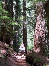
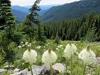
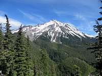
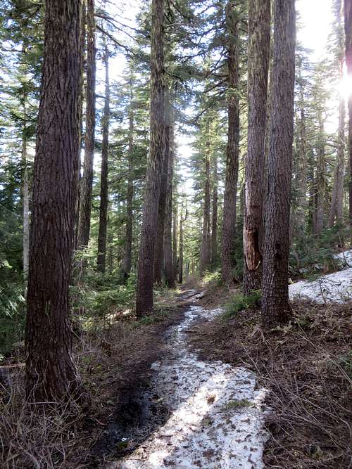
The hike up the Whitewater Trail and the Pacific Crest Trail was absolutely gorgeous and I enjoyed it a lot, despite the fact that my pack felt unusually heavy for just an overnight trip. The Whitewater trail begins with gradual switchbacks through an old growth forest of Douglas Fir and Pacific Silver Fir. As you get higher the trees get smaller, and eventually you are greeted with views of Mount Jefferson. The first time we saw the peak we were pretty intimidated by the view; we could see our intended route up the Jefferson Park Glacier and it looked a long ways away, not to mention the visible crevasses and bergshrund we would have to negotiate. But we kept moving along as we increased elevation and passed some gorgeous wildflowers, most notably Oregon Beargrass, which was everywhere. There were also a lot of birds in the forest that serenaded us the entire way to camp - Oregon has a wide variety of bird species compared to mountains in Colorado and they made some awesome music for us.
![old growth]() Old growth forest
Old growth forest![Mount Jefferson wilderness]() Beargrass meadows
Beargrass meadows
After a few miles the Whitewater Trail met up with the Pacific Crest Trail at a switchback - we joined the PCT and stayed to the left (uphill). This trail traversed around and down to the river crossing below. We crossed the river by stepping on some widely spaced dry boulders; I had to use a long stick for balance but didn't get my shoes wet. I imagine this crossing is a little more tedious earlier in the summer when the water is higher, but later in the summer it is probably a piece of cake. Soon after this crossing we encountered pretty consistent snow on the PCT and lost the trail. It was around 5pm at this point and we weren't really sure where Jefferson Park was. Most people camp at Jefferson Park - a gorgeous alpine lake setting along the PCT that apparently has awesome views of Mount Jefferson and numerous campsites around the lakes. We intended to camp here and head up the peak early in the morning, but due to the snow we had no idea where the lakes were. After some wandering around we decided to just head straight up towards the Jefferson Park Glacier to treeline and camp up there.
![Mount Jefferson]() Mount Jefferson (our route goes up the left side of the peak)
Mount Jefferson (our route goes up the left side of the peak)![snow gully]() Heading up the snow gully to treeline
Heading up the snow gully to treeline
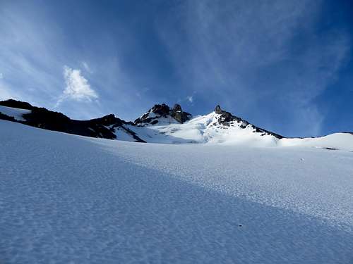
We headed up through the woods to the right of a snow-filled gully, eventually traversing into this gully and going up it since travel was easier. We got periodic views of the open terrain above and knew we would eventually get somewhere. The trees kept getting smaller and smaller and soon we found ourselves above treeline on the snow and moraine below Jefferson Park Glacier. The views were amazing - we saw our intended route up the glacier up above us, the rock pinnacles below the summit (the summit though was out of view), as well as peaks we knew out in the distance - Mount Saint Helens, Mount Rainer, Mount Hood, and Mount Adams. Being above the blue rolling hills surrounding these peaks was something I had really missed about the PNW and it was great to be here again, especially this time of day as the sun started to set. We also noticed some snow-covered lakes down at treeline...Jefferson Park! Turns out we were nowhere near it. This was fine with us though - Jefferson Park was still mostly snow-covered (and probably mosquito infested), plus we were above it now and would therefore have a shorter day tomorrow.
![Jefferson glacier]() Approaching camp with Jefferson Park Glacier in the distance. The bergshrund and saddle are in betweeen the two spires
Approaching camp with Jefferson Park Glacier in the distance. The bergshrund and saddle are in betweeen the two spires
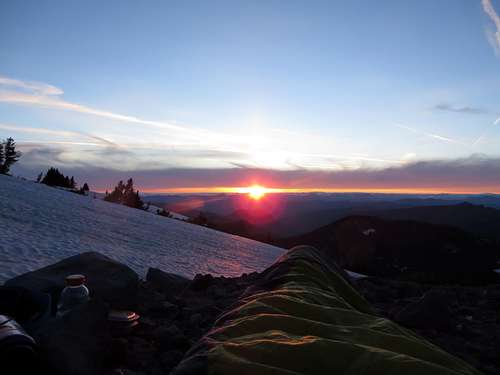
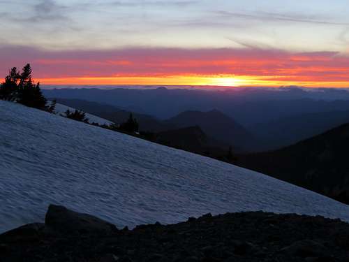
We found a flat camping spot on some moraine next to the snow and started making dinner. Brendan and I had recently gotten back from climbing Denali in Alaska and still had backcountry cooking fresh in our minds. We fired up an XKG stove and made some chicken noodle soup with cheese and salmon tortillas - one of our favorite meals from Denali. After this we melted some nearby snow for water and headed to bed, mentally preparing for a big day tomorrow. There was no need to set up a tent due to the awesome weather and lack of mosquitoes (something I've learned Oregon has a lot of), and we soon fell asleep after seeing a beautiful sunset below us to the west.
![Mount Jefferson sunset]() Sunset from camp
Sunset from camp ![Sunset on Mount Jefferson]() Alpenglow on Jefferson
Alpenglow on Jefferson![Sunset]() Sunset
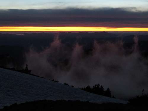
Sunset ![low clouds]() Low clouds drifting about after sunset
Low clouds drifting about after sunsetDay 2 - 7/4/14
As always, the alarm went off all too soon in the morning at 5am. It was already light out and the sky revealed a few early signs that the sun was soon coming up. We got our packs ready for the day and anchored our sleeping bags down with some boulders. There wasn't a need to bust out the crampons or rope just yet. We left camp around 6:30am and hiked up the snow and moraine to where the actual glacier started. The moraine in this area was incredibly loose, and it was obvious that at one time the Jefferson Park Glacier extended down the mountain even further. Once we got on continuous snow we put on our crampons and roped up. I led first up the glacier, and it was fun to set my own pace and decide the route. There weren't any visible crevasses initially, but we soon encountered them higher up.
![On the Jefferson Glacier]() On the jefferson Park Glacier
On the jefferson Park Glacier
We stayed along the left side of the glacier all the way up to the large crevasses below the bergshrund, then angled right below the cliffs to the base of the bergshrund. The snow was a lot softer than we would've liked; it was pretty warm out, there hadn't been a good freeze overnight, and the sun was already starting to have an effect. However, we continued upwards, only really worried about rockfall at this point. There had been a really recent (probably the previous day) avalanche on the right side of the glacier, possibly caused by serac fall, but on the left side there was nothing that caused us to worry about avalanches. We hurried through some rockfall areas, definitely having to look up constantly for rocks. Some small rocks whizzed by pretty close to us, but we remained unscathed. We had previously contemplated going up the middle of the glacier because it was more direct and less prone to rockfall, but in hindsight we're glad we didn't because there were numerous snow bridges to cross (not a good idea in the warm conditions) and there was a large crevasse at the top out of view that would've made travel difficult.
We had been worried about the bergshrund crossing for most of the trip. It looked like a pretty large bergshrund from a distance and as we got closer we weren't sure how we were going to negotiate it. Plus, we had a 35m rope with us that might not be long enough to go up or down it. There seemed to be a few possible places to cross, but as we approached the base it became clear which way was the easiest, and it didn't even look too challenging (assuming we didn't fall in). So, I told Brendan that I wanted to stay in the lead and go up and across the snow bridge, which was on the left side of the bergshrund. The snow turned out to be solid, and once I got across the snow bridge I felt very relieved. It's always cool looking deep into crevasses, it's like you've temporarily joined another world that is cold and unforgiving and unsurviveable. But then you realize that you've got everything you need to survive, and you continue upwards.
![the bergshrund]() Approaching the bergshrund
Approaching the bergshrund![Jefferson glacier]() Brendan and the Jefferson Park Glacier
Brendan and the Jefferson Park Glacier![Bergshrund crossing]() Bergshrund crossing
Bergshrund crossing ![close-up of the crossing]() Close-up of the bergshrund crossing and snow bridge
Close-up of the bergshrund crossing and snow bridge
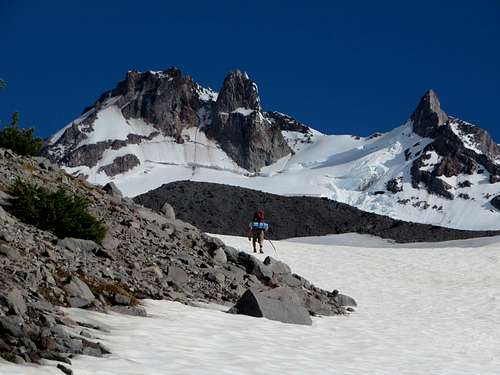
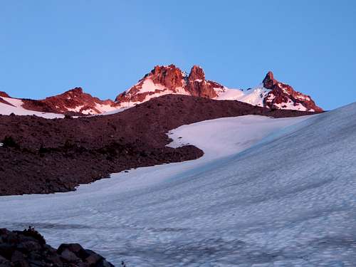
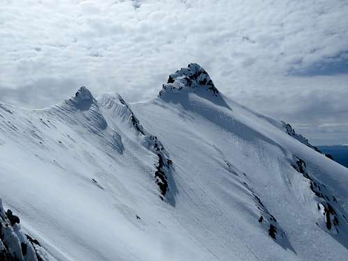
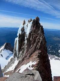
Above the bergshrund the terrain got considerably steeper. Even though it was soft down lower, this section had been in the shade more and required some front-pointing and use of both ice axes at times (both Brendan and I had brought one ice tool and one mountaineering axe each). I continued upwards to the saddle above, and Brendan crossed the bergshrund with ease. Once we reached the saddle we took a much needed break. Here we had some incredible views, most notably the spire directly next to the saddle which was encrusted with vertical ice/snow and very jagged rock. Next to it was the knife edge ridge, as well as a view of the summit in the distance. It was still a long ways away, and as we figured out our route on the ridgeline it became clear that we still had some tricky terrain ahead of us. At first we thought we could bypass the knife edge ridge to the right, but after some exploring it was clear that wasn't an option. We would have to go up and over this ridge, which, upon first glance, looked pretty difficult. Brendan took over the lead and we shortened our rope, since it was clear we would have to climb up some 5th class terrain with intermittent snow.
![The ridge]() Initial section of the knife-edge ridge. The route stays on the ridgecrest direct
Initial section of the knife-edge ridge. The route stays on the ridgecrest direct ![the saddle]() Looking back down at the saddle and Jefferson Park Glacier
Looking back down at the saddle and Jefferson Park Glacier![The summit]() Mount Jefferson summit! Our route traversed the left ridge and then went straight up the middle of the summit pinnacle
Mount Jefferson summit! Our route traversed the left ridge and then went straight up the middle of the summit pinnacle
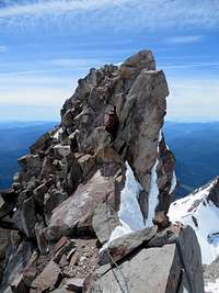
The ridge began with a brief steep section of low 5th class rock, followed by an extremely exposed ridgeline. There was an occasional solid hold, but in general the ridge had a lot of loose rock and every hold had to be double and triple checked. There were also some sections with snow which either increased or decreased the difficulty depending on where it was. The infamous "knife edge" was bare of snow, but still required careful footing. We wore our crampons for the entire ridge which seemed to be a good idea. Brendan placed occasional protection (a few cams and slung a few rocks), but regardless, a fall from either of us would have been very bad. Eventually the ridgeline mellowed out; it was now mostly snow-covered and the travel was a lot easier and less exposed. We followed it around to the base of the summit pinnacle, traversing below some rimey snow flutings towards a gully that looked promising. We could have stayed closer to the north ridge and headed up towards the summit that way (the easiest route), but curiosity got a hold of Brendan and he headed towards a gully on the west side that turned out to be a short WI4 section. As he rounded the corner I heard him exclaim, "This is gonna be AWESOME!"
I put Brendan on belay and he started up the ice, placing a couple of screws before disappearing out of view. At this point I was just hoping I'd be able to climb it too, but it looked doable. For this section we used our ice tool in the left hand and had perfect rock holds for the right hand. I reached Brendan at his belay station, which was on a nice rocky area with good places to set up an anchor. Before I had a chance to breathe a sigh of relief he told me, "Take us to the top!" Above him was the last pitch up to the summit, and it was considerably easier than the gully we had came up, albeit still rocky/icy terrain. I visualized the easiest way up in my head, just hoping I wouldn't encounter scary terrain that was out of view. Brendan belayed me up, and at first it wasn't that steep, but soon got steeper and icier so I put in a couple of ice screws and continued up to the ridge crest. I poked my head around the other side, happy to not see a vertical drop-off, and saw the summit just a little bit higher to my left. Once I was on the ridge the going was easy, and before I knew it I was on the summit! It was around 1pm, and had taken us about 6 hrs and 30 min to summit from camp.
![Ice pitch]() WI4 section
WI4 section![looking down]() looking back down the upper pitch
looking back down the upper pitch![summit views]() Summit views to the south
Summit views to the south![summit views]() Summit views to the north
Summit views to the north
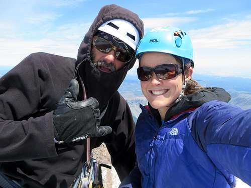
I brought Brendan up and we signed the summit register, surprised to see no other names in there since 2013 (after some investigation on Summitpost though it's clear at least one person climbed it this past winter, and possibly more since then). We were extremely happy and satisfied to have reached the summit...even having recently been on Denali, Mount Jefferson was one of the best climbs either of us have ever done. We still had a long way to go though back to camp and back to the car. The weather was still great, but we had lots of serious terrain to descend, not to mention through snow that had been getting softer and softer all day long.
![summit]() Halfway there!
Halfway there!
We contemplated descending down the Mill Creek Glacier side of Jefferson a little ways and then climbing back up to the saddle above Jefferson Park Glacier to avoid the knife edge ridge, but we figured it'd be faster and less exhausting to just go down our ascent route. We would've had to drop down a ways in order to get around the ridge, and the climb back up to the saddle didn't look too fun. In hindsight though it might've been easier and less nerve-wracking, because descending back down the knife edge ridge was a whole lot scarier than climbing up it! (Note: apparently it's also possible to descend down the Mill Creek Glacier, cross over to the Russel Glacier, and then over to the base of the Jefferson Park Glacier...this might've been easier as well!)
There was a rappel set up on Jefferson's summit with webbing and a rap ring, and we set up our 35m rope and threw it down the west side we had climbed up. Unfortunately it only reached about halfway down the upper pitch I had led (a 60m or 70m rope would be the prefect length!). Still though, this seemed like a better option than downclimbing the north ridge off the summit, for which we had no beta on. Brendan went first, got off the rope, and I followed. At first I didn't think downclimbing the rest of the way would be a big deal, but once I left the security of the rope my feelings changed.
Brendan anchored himself in and put me on belay, since I wasn't feeling that confident downclimbing the icy sections without a second ice tool. With him belaying me from above, I downclimbed towards his previous belay station, putting in one ice screw for when he downclimbed after me. I reached the safety of belay station and belayed Brendan down. Luckily he also expressed some discomfort with having to downclimb that terrain, so I didn't feel like to much of a wimp! When he got to me he continued on snow around to the right, since we wanted to see if there was easier terrain to descend instead of rappelling down the WI4 gully we had climbed up. It was easier around the corner so I followed, and we eventually reached a large boulder that had some old webbing for a rappel. We rapped down one more steep section (this time our rope was long enough!) and then continued below the icy flutings that we had gone below on the way up. I could definitely tell I was getting tired because this time around I was a lot more unsure of my footing/axe placements, whereas on the way up this traverse had been no big deal. But soon we were back on easier terrain, heading towards the knife edge ridge.
![Rapping down the first pitch]() Rapping down the first pitch below the summit
Rapping down the first pitch below the summit![looking back up]() Looking back up at the final summit pitch that we partially downclimbed
Looking back up at the final summit pitch that we partially downclimbed![rapping down]() Rapping down the second pitch to easier terrain. The remaining route before the knife edge ridge is in the background
Rapping down the second pitch to easier terrain. The remaining route before the knife edge ridge is in the background![summit pinnacle]() looking back up towards the summit
looking back up towards the summit![summit]() Summit
Summit ![knife edge ridge]() Some of the knife edge ridge
Some of the knife edge ridge
At this point it had gotten very windy, and that just added to our desire to get down soon. Luckily it was still warm, otherwise the wind would've been killer. Brendan mentioned possibly having to camp another night at the base of the glacier if we got down too late, but I dismissed that idea since we had barely any food left. Brendan led again going back down the knife edge ridge, and we shortened the rope as before. Not only were we more tired this time around, but we had to downclimb some sections on the ridge that we had previously climbed up. Most people know it is usually harder to climb down stuff than climb up it, and for these reasons the ridge really kicked our butts. It never seemed to end! The last part was probably the hardest because we had to downclimb the low 5th class section with snow that we had encountered first on the way up. We were both very relieved to be off the ridge and back on the saddle, although we had even more worries coming up with descending the glacier.
![knife edge ridge]() Heading down the knife edge ridge
Heading down the knife edge ridge![cool spire]() An awesome spire next to the saddle (note: this isn't part of the route!)
An awesome spire next to the saddle (note: this isn't part of the route!)![knife edge ridge]() One of the "easier" sections of the ridge
One of the "easier" sections of the ridge![knife edge ridge]() Looking back up the knife edge ridge
Looking back up the knife edge ridge
We lengthened the rope to 35m again and Brendan went first on down towards the bergshrund. The snow was a lot softer than before but still felt somewhat stable, and we were able to make good time by plunge-steping down to the bergshrund. I was glad it wasn't hard like in the morning, otherwise I probably would've had to descend facing in. When Brendan reached the bergshrund we saw some rocks whizzing down to our right, going right over where we intended to cross. We had no other choice but to just get through the area as quick as possible, so once the rocks had stopped Brendan hurried down over the snow bridge and to the flatter area below. I followed, trying to move as fast as possible before more rocks came down. Then we both hurried to the right below the cliffs, around the crevasses, and down the side of the glacier via the same route we had ascended. Luckily there wasn't anymore rockfall that affected us, and soon we were on the lower glacier.
We were able descend the remaining snow with ease, and before we knew it we were back to camp. It was 5pm, earlier than we thought we'd be back. We decided to just pack up and head back to the car, not bother with melting more snow for water or taking a nap. At times huge feelings of relief would flood over us, since now we knew we were off all the hazardous terrain and just had a nice walk through the woods ahead of us. By 6pm we were off, and we headed down the snow-gully that we had encountered on the way up.
This time we followed the snow gully all the way to the valley floor below. The snow was the perfect softness to make travel fast via lots of boot skiing, and it made a lot more sense to descend down the gully than deal with the terrain in the forest. At the bottom of the gully we headed to the left, and I knew that if we just kept heading left we'd eventually meet up with the PCT at some point and get down to the river crossing. Eventually we did, as was evident from the numerous footprints in the snow probably heading up to Jefferson Park. We followed the tracks and the trail back down to the river crossing, saw two other backpackers - the only people we'd seen during the trip. They were headed for Jefferson Park, and soon after we met two other people that intended to climb Jefferson via our route. We gave them some info and wished them the best of luck.
After the river crossing we entered "zombie mode" and followed the trail back to the trailhead, arriving at 8:15pm. There were more cars in the parking lot this time, and we figured they had all gone to Jefferson Park to celebrate the 4th of July. Upon reaching the car we ate every ounce of food that we had left behind, then made the beautiful drive back to the town of Sisters. We stuffed our faces and then inquired about any fireworks happening that night. The only response we got was "We try to keep this town quiet." In other words, no. Probably for the best though because we were exhausted and just wanted to sleep, which we proceeded to do.
![the PCT]() Hiking out on the PCT
Hiking out on the PCT
All in all, this was a beautiful climb - not just the scenery, but the climbing itself was top-notch because there was a little bit of everything involved! It was awesome being the only people on such an exquisite and unique route, and I truly felt like I was in a "wilderness area". I highly recommend Mount Jefferson via the Jefferson Park Glacier to anyone who wants a challenging adventure in a gorgeous setting, and a five-star climbing experience!
Additional Info!
* A Northwest Forest Pass OR a 5$ day pass is required at the trailhead.
* Rough estimates on elevation gain and round-trip mileage: 7000' and 12 miles.
* We saw some old tracks in the snow coming up the Mill Creek Glacier side that looked like they had originated down by Pamelia Lake. This way looks like it might be easier than the other routes - shorter and more direct. No huge crevasses either that we could see, looks like mostly just a steep snow climb.
* We didn't inspect conditions off the other side of the summit, but according to Summitpost the north ridge is the easiest way to get up the summit pinnacle and goes at 4th class. Snow would add some difficulty though.
* We figured that if the bergshrund crossing didn't work, we could go up to the rock saddle on the left side of the glacier and go up the Whitewater Glacier route instead. Sounds like the south summit pinnacle is challenging though!
* We didnt' see any trail junctions before the PCT trail like it mentions on Summitpost (trail 3373?), We just followed the Whitewater trail and it eventually met with the PCT.
* Directions to the trailhead from Bend: take Hwy 20 north to Sisters, continue north on 126/20 and then north on 22. Turn right on Whitewater Creek/USFS Rd 2243 and drive 6 mi to the TH.


Comments
Post a Comment