
-
 2514 Hits
-
 79.78% Score
-
 11 Votes
|
|
Mountain/Rock |
|---|---|
|
|
46.47272°N / 13.41624°E |
|
|
Download GPX » View Route on Map |
|
|
Hiking, Scrambling |
|
|
Summer, Fall |
|
|
6457 ft / 1968 m |
|
|
Overview
Monte Gosadon is a mountain of secondary importance in the Malborghetto mountain chain, Viš and Montaž group. But its position just opposite of Montaž, the great ruler of Western Julian Alps, makes sure that it is well worth of a visit. In addition to great vistas, solitude and mountain wilderness, Gosadon offers also a few nice hikes, which can be combined into round tours. All of them are at least medium difficult.
The name
Nowadays it looks that Gosadon is prevailing, so despite the territory where four ethnic groups live, I'm keeping in the title only this name. The Slovenian and German name can also be found: Tri špice and Dreispitz (both meaning the same - three peaks). But old sources are also revealing that the mountain was in the past called only Cuel delle Tane dell'Orso (meaning: The peak of bear hole). As obviously bears are not residing on summits, today on the Tabacco map 'Le Tane dell'Orso' is located on the southern slopes of our mountain - if opted, I would also choose a sunny balcony.
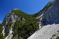
Geography
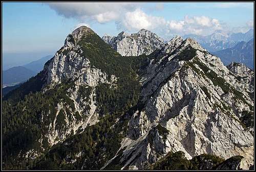
 The three summits of Monte Gosadon (on the left)
All cardinal summits of the Malborghetto chain are arranged in the main streak. Gosadon rises in the middle of it. Coming down from the higher NE neighbour Due Pizzi (from Cima Alta, 2046 m), the main ridge lowers on a saddle of some 1850 m, and then towards the SW rises again on the highest peak of Gosadon, 1968 m. Further to the west in the rocky ridge there are also the middle peak, 1937 m, and the western peak, 1902 m. Both have no distinct names and the whole ridge is anyway sharp and very rugged. Even the military path from the World War I avoids it low by the northern side, coming up on the ridge again already close to the next distinct mountain, called Cuel dei Piez, 1943 m. Both sides of our three-peak ridge are steep and rocky, at least in the summit part. Towards the north some vertical walls are falling on quite broad scree slopes, towards the south crags are more intermitted and overgrown by dwarf-pines and steep grassy slopes. East of Gosadon, below the summit rocks, the broad screes are filling the valley, descending from below the south wall of Due Pizzi. Northwest of Gosadon, there's on 1528 m a broad alpine pasture, called Malga Granuda (in Slovenian: Planina v Dupljah).
Geology
As all other summits in the Malborghetto chain, also Gosadon is made of a friable triassic Schlern (Sciliar) dolomite. In lower regions, the lithology of Malborghetto mountains is more complex (especially on the northern side).
Summit Views
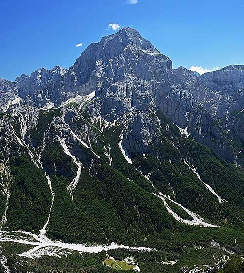 Montaž
The mighty Montaž is for sure the central feature of Gosadon's panorama. We see it from the northwest, so it is still elegant and rising very high (2000 meters) above the Dogna valley, but we can already see also some features of its broad north wall. Viš, the other giant of the group, is standing a bit in the background. Further on the east we see some high summits of the Eastern Julian Alps (Mangart Jalovec, etc.), and then the nearby scenery locks our views. Nicely we see Monte Piper and Due Pizzi. The views on all other sides are completely opened, as Gosadon is exceeding by altitude the easternmost summits of Carnic Alps. So, Gailtal Alps, Hohe Tauern, Carnic Alps and Southern Carnic Alps can nicely be seen. Towards the west all the remaining summits of Malborghetto chain are stretching and on the other side of Dogna valley there's the wild group of Monte Cimone.
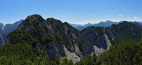
 Towards Due Pizzi and Monte Piper
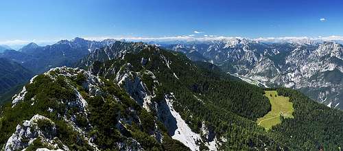 The W and NW views
World War I
Even if on Gosadon there were no severe fightings, the summit was well fortified. From Plan dei Spadovai in Dogna valley even a material cable way was reaching it. All paths on the mountain were done during the war and especially the southern ascents are revealing many remains from that time - buildings, caves, trenches, fortifications, posts. During the war the frontline was not moving much. The Austro-Hungarian army was keeping only the eastern fore-summit of Iof di Miezegnot/Poldnašnja špica, far on the eastern end of Malborghetto chain. The main summit of that mountain, and all the summits towards the west were held by the Italian army. Actually it all revolved around the question who will hold the strategically important Val Canale, north of the Malborghetto chain, which was, as centuries ago, opening the door into Kaernten.
Getting There
The tours on Gosadon can be started either from the north (Val Canale) or south (Val Dogna). Through Val Canale the A23 highway runs. You exit it either in Pontebba or in Camporosso and then drive to trailheads by local roads. The highway exit for Dogna valley is also Pontebba, then you drive southwards and deter eastwards into the valley. All trailheads are listed in the next chapter.
Hiking Routes
Hikers with a certain level of mountaineering experience are the only visitors of Gosadon. Here are the main routes, which can be also combined:
1. From Malga Granuda, 1528 m.
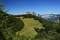 Malga Granuda
This alpine pasture can be best reached by two routes. The first one is simply the mountain road from Malborghetto (actually from Cucco, west of Malborghetto). From Cucco we cross the river of Fella, drive below the ex railroad (now the cycling trail) and then immediately turn west and drive some 700 m. After crossing Rio Granuda Grande there's the crossroads, where we turn left (from the right the road from Santa Caterina comes). After some 300 m we park below the highway (46.497527, 13.414044). The road further on is closed for public traffic, on foot we reach Malga Granuda in some 2 hours. For biking this road is steep and rugged, but still worth considering (you profit on the descent). The second route to Malga Granuda is the marked path No. 604 from Bagni di Lusnizza. We park in the eastern part of the village, again near the highway (46.497704, 13.384122). From there the path goes in endless turns up through the woods, until it exits on the meadow (2 h 15 min).
 Gaining the saddle
The summit ascent starts on the lowest, southern end of Malga Granuda. The marked path No. 604 deters from the mountain road on a big curve, there are the plates. In the southeastern direction we continue through the high woods - the place is called Močila (='sources'). We cross a few ravines, then we ascend more steeply by scree slopes. Above there is on some 1690 m a crossroads. We reached the ex military trail Sentiero Battaglione Alpini Gemona (No. 649). We follow it to the left and by a steep passage (T3) gain a small side ridge. After crossing it we find ourselves on the western end of broad scree slopes. We cross them high below the vertical walls, then we negotiate another unpleasant rocky passage (T3) and finally through the high woods and dwarf pines reach the saddle between Due Pizzi and Gosadon. The crossroads is on some 1850 m and it's hard to notice it! While the path straight continues towards Due Pizzi, we plunge into dense dwarf pines towards right. But the path is fine and easy to follow (it's not marked). At first it is cut through the grenery and it horizontally crosses much towards the right. So it detours the first ridge bump. Then it turns steeply up, climbs over another steep rocky passage (T3) and then continues in more comfortable turns up. Just below the summit there's the last crossroads. A wooden arrow directs us left down towards Dogna valley, while we deter right up and reach the summit in a few minutes. This is the easiest ascent route on Gosadon. By the Swiss Hiking Scale it would be rated T3. Some short passages require a safe step, but none is really difficult or too exposed. Some attention when orienting is needed only in the last part. From Malga Granuda 1 h 30 min. Gear: only good hiking shoes and poles.
2. From Plan dei Spadovai, 1100 m.
We reach Casera Plan dei Spadovai (46.461835, 13.423213) by the narrow, but well maintained asphalt road through Dogna valley. From there we continue up the slope until we hit the marked path No. 605 (starting on the road a bit lower). Along the ravine of Rio Cjanalut we ascend towards the N-NE until we reach the crossroads on 1608 m (on the bottom of big screes below Due Pizzi). There we turn left and continue by the ex military path (not marked). One exposed ledge is secured, then we continue steeply up (westwards). After another path comes up from the valley, we turn right towards the summit. First we gain the ex cableway station and from there on old, unreliable pegs and cables help us to climb some steep rocks. Just below the summit we hit the route #1. This route is more often used, but is supposedly a little harder than the route #1. Some 3 h.
3. From Ricovero Bernardinis, 1907 m.
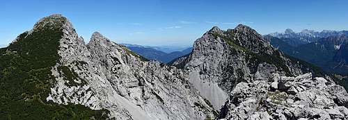
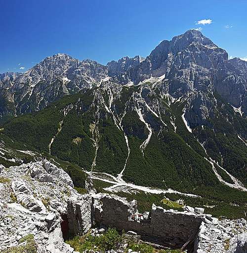 Summit view: Towards Viš and Montaž
This bivouac (ex military building) stands on the eastern side of Due Pizzi, above Forchia di Cjanalot, 1830 m (notch). This notch can be reached either from the southern (Dogna) side or from the northern side. From Malborghetto (north) the marked path No. 605 comes up (some 1120 m, 3 h 30 min). From the Dogna road, we can start the bivouac approach either on Pian dei Spadovai, 1100 m (marked path No. 605), or higher, if we park on 1268 m. There the path No. 648 starts. It is shorter, but also more demanding. It ascends first northwards by the slopes of Monte Piper, then on 1749 m it branches. While the right branch goes on Monte Piper, the left branch crosses the steep, quite exposed slopes towards Forchia di Cjanalot. That part is secured, but the devices are not always in good conditions. Below the notch both paths from Dogna road join.
Also the continuing from the notch and bivouac is quite demanding and very exposed. That's the very attractive ascent route on Cima Alta (the higher of Due Pizzi). It first crosses the steep northern slopes of Cima Valdiver, then it enters the ex military tunnel. Having a lamp for it is very recommended! After exiting on the southern side of the main ridge, the path continues towards the natural rock window - another attraction. After we go through it, the path descends steeply and finally hits the attractive artificial ledge, which horizontally crosses the whole vertical, southern wall of Cima Alta. Also there the protection devices (cables) are not always in good conditions. The crossing finishes on some 1910 m, when this route hits the marked path, coming up from the SW saddle.
For Cima Alta we turn right and reach the summit in some 15 minutes, for Gosadon we descend some 60 m and then find the place where we deter left into dwarf-pines (route #1).
From Ricovero Bernardinis we need to Gosadon summit 1 h, difficulty would be T4 (depending on conditions of security devices). Gear: Good shoes, poles, battery. The combination of routes #2 and #3 is a wonderful, very attractive tour. Other combinations are more rarely done. Along the whole Malborghetto mountain chain the marked Sentiero Battaglione Alpini Gemona goes. But maintaining of that nice path was abandoned, so nowadays (2017) many sections are dangerous and hardly passable. Those who would attempt to cross all summits from Iof di Miezegnot to Iof di Dogna should count on collapsed bridges, free hanging cables, missing path sections due to landslides and other challenges. Those who can manage them, can easily do a side jump on Gosadon as well.
Maps: The above OpenStreet Map is very accurate, also the paths. Otherwise the Tabacco No. 018 map can be recommended (Alpi Carniche Orientale, Canal del Ferro).
Mountain Huts
As now Sentiero Battaglione Alpini Gemona is abandoned, the summits of Malborghetto chain are mostly climbed in day tours. Still, the Ricovero Bernardinis can be used and on Malga Granuda there is also a shelter available.
When To Ascend?
 Summer hike up
Gosadon can be best ascended during summer and autumn months. Winter conditions can make the tour more difficult. Malga Granuda is being advertised even as a destination for snow-shoes tours. I don't know if the hut is really opened in winter, because we came there mid July and there was still nobody on the pasture. In winter conditions the ascent from Malga Granuta on the summit of Gosadon is for sure not trodden, some parts are dangerous for avalanches and in harder snow you'd need crampons and ice pick. Gosadon is not a ski touring summit (while Cima Alta can be).
