
-
 9322 Hits
-
 78.27% Score
-
 9 Votes
|
|
Mountain/Rock |
|---|---|
|
|
27.89504°N / 15.69127°W |
|
|
4019 ft / 1225 m |
|
|
Overview
 Montaña de Tauro seen through a breach in the Cumbre Central Montaña de Tauro seen through a breach in the Cumbre Central |
Gran Canaria is a typical island among the Canaries. Almost 2000m high the central mountains, the Cumbre Central, divide it into two completely different parts. While in the north-east of the Cumbre fog and rain paint the island green the south-west is barren and dry. Except for several reservoirs which provide badly needed water to the villages and tourist resorts in the south there is little water to be seen. Still, over the ages impressive, canyon-like barrancos have been carved out of the soft soil, often leaving tall walls to either side of the barranco bed.
One especially impressive canyon is Barranco de Mogan in the south-west of the island. Here the Laderones de Mogan tower about 1000m above the small village. These walls are the north face of Montaña de Tauro, a small but very interesting mountain. From afar Montaña de Tauro looks like cut-off pyramid. big, sloped walls rise up in the north and east of the mountain only to form a wide summit plateau on the top. The real summit is set back a little above a winde ledge, which follows the big walls in the north end east. Getting closer the summit vanishes out of mind and sight as the Laderones, those 1000m high walls take center stage.
 |  |  |  |
The Laderones de Mogan follow the length of the Barranco from its start in the central plateau of Gran Canaria towards the sea. The most impressive section is right at the start where the bbarranco drops away and leaves almost vertical walls standing to the south. As you move towards the mouth of the bbarranco the walls turn into slopes, steep on top but only 45° at their very base inside the creek bed. To the east similar walls tower above Barranco de San Andres, steeper still than the Mogan ones but only 600m high.
 |  |  |
To summit Montaña de Tauro you only need about two hours as the closest trailhead is in the place where north and east faces meet on top of the central plateau. A well kept trail heads up to the ring-ledge where the ruins of shepherd huts can be found. The final ascent to the summit is a trail-less scramble up a steep soft slope. Without the giant cairn on top the actual summit of the mountain would be hard to find, thanks to its plateau-like form. It is definitely recommendable tohike along the Laderones de Mogan and enjoy the breathtaking views into the barranco and beyond.
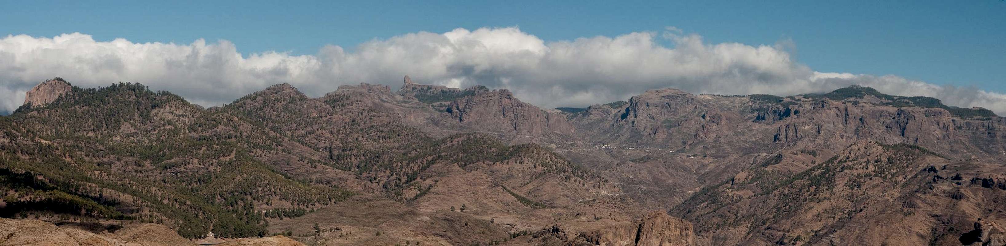
Summit Panorama
  |
Getting There
Gran Canaria can be reached from any major European airport. Usually charter carriers fly there but the spanish airline Iberia has also regular flights. The airport is on the eastern coast of the island, far away from the tourist centres in the south and south-east.The trailhead for Montaña de Tauro is far away from any habitation and it is lengthy to reach. From the airport, the shortest access (timewise) is along the Autopista del Sur de Gran Canaria which stretches between Las Palmas and Puerto Rico. A more scenic route is across the Cumbre Central, the central highlands of Gran Canaria.
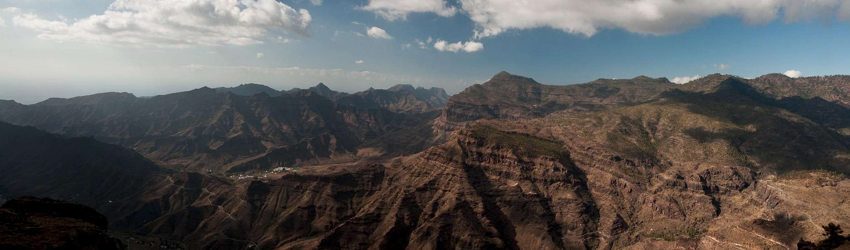
 Looking back towards the Pajonales Ridge during the ascent to Montaña de Tauro
- Southern access
- From the airport take motorway GC1 south all the way to its end at Puerto Rico.
- Switch to highway GC500 until you reach Playa de Mogan.
- Take GC200 to Mogan and beyond.
- Where the highway turns left in a sharp switchback, GC605 turns off straight and winds upwards towards the big western plateau of the island.
- Almost on top of the plateau, again in a sharp turn left the road to El Baranquillo de San Andres turns off right.
- After some 1 - 2km you get to a small, dried-up reservoir on the left hand side. Park here or a few metres beyond on the right hand side of the road, where the tril to Montaña de Tauro starts.
- Across the Cumbre
- From the airport take GC1 northward .
- At the exit Telde turn onto GC10 westward.
- After Telde the highway turns into GC41.
- At Lomo de la Herradura turn off left onto GC131 / GC130, which leads all the way towards Gran Canaria's highest mountain, Pico de la Nieve.
- Right after the mountain turn left onto GC600 to Ayacata.
- In the village turn right and immediately left onto GC605 which passes the reservoir Embalse de las Cuevas de las Niñas.
- Right befor the road starts winding down towards Mogan turn off left in a sharp turn towards El Baranquillo de San Andres.
- After some 1 - 2km you get to a small, dried-up reservoir on the left hand side. Park here or a few metres beyond on the right hand side of the road, where the tril to Montaña de Tauro starts.
Red Tape
 |
The area of Montaña de Tauro has been declared natural monument Monumento Natural de Tauro. The usual restrictions for natural parks apply. The rock walls of the Laderones are fragile and offer a nesting ground for Gran Canaria's birds of prey, mainly buzzards and falcons. Take care not to disturb them in the nesting season in spring.
Accommodation
 Ruins of an old farmstead on top of Montaña de Tauro
Gran Canaria has a lot of options for accommodation. Most visitors book hotel rooms from their travel offices or over the internet. However, you will most certainly end up in the ugly tourist centres along the south coast. Therefore a much better solution is to rent a holiday home, most often a rural finca. This can also be done by travel office or internet.
Camping is a bit of an issue on all the Canary Island. There are designated camping zones but getting a place often involves some bureaucracy. The closest campground is at Embalse de las Cuevas de las Niñas some 4km to the north-east of the mountain. Wild camping is not permitted anywhere on the island.
Weather Conditions
The following table gives a rough general overview over the weather on Gran Canaria, at sea level.| Month | Jan | Feb | Mar | Apr | May | Jun | Jul | Aug | Sep | Oct | Nov | Dec |
| Avg. day temp.[°C / °F] | 21 / 70 | 21 / 70 | 22 / 72 | 22 / 72 | 22 / 72 | 23 / 73 | 24 / 75 | 25 / 77 | 25 / 77 | 25 / 77 | 24 / 75 | 22 / 72 |
| Avg. night temp.[°C / °F] | 16 / 61 | 16 / 61 | 16 / 61 | 17 / 63 | 16 / 61 | 17 / 63 | 18 / 64 | 20 / 68 | 20 / 68 | 18 / 64 | 18 / 64 | 17 / 63 |
| Water temp.[°C / °F] | 19 / 66 | 18 / 64 | 19 / 66 | 19 / 66 | 19 / 66 | 20 / 68 | 22 / 72 | 23 / 73 | 23 / 73 | 23 / 73 | 21 / 70 | 20 / 68 |
| Rainy days | 4 | 3 | 2 | 2 | 1 | 1 | 1 | 1 | 1 | 3 | 3 | 3 |
The Canarian Islands (as well as Madeira) are located in the trade wind zone. You almost always encounter northeastern winds which carry a lot of humid air. Being forced to climb to higher altitudes this moisture condenses into clouds. This in return means that most of the time the northeastern part of the islands is covered in clouds from altitudes of 1000m through 1500m.
The mountainous region in the centre of the island is of the same alltitude and higher and thus stops the clouds. While the northern parts of the islands can be foggy and rainy the southern parts most often are sunny and hot. On Gran Canaria the north-eastern part of the island collects almost all moisture. However, unlike on the other Canary Islands no cloud forest remains. The laurisilva fell victim to the agricultural development of the island.
Maps & Books
Regular Maps
- Gran Canaria
Kompass Map WK237
Kompass Verlag
1:50000
ISBN 3-85491-114-9
- Gran Canaria North
Public Press Map 442
1:50000
ISBN: 978-3-89920-442-1
- Gran Canaria South
Public Press Map 443
1:50000
ISBN: 978-3-89920-443-8
Digital Maps
Kompass is the only company known to me which offers GPS digital Maps. In addition for those of you with Garmin GPS receivers there is a map source map set of all Canary islands out there.
- Gran Canaria
Kompass GPS4237
Kompass Verlag
ISBN 978-3-85491-219-4
- Islas Canarias
Map Source custom map
By Manfred Pepper
downloadable zip-file
Books
My recommendation is a guidebook by Rother Verlag, available in English and German. The book is an excellent hiking guide covering all the interesting areas of the island. Since it comes with small maps for each excursion it might even be used without a map to support them.
- Gran Canaria
Izabella Gawin
Rother Verlag
ISBN 978-3-7633-4816-9 (English)
ISBN 978-3-7633-4000-2 (German)