
-
 15800 Hits
-
 89.01% Score
-
 28 Votes
|
|
Area/Range |
|---|---|
|
|
46.33722°N / 12.07473°E |
|
|
Hiking, Mountaineering, Trad Climbing, Scrambling, Via Ferrata |
|
|
Spring, Summer, Fall |
|
|
9442 ft / 2878 m |
|
|
Overview
Moiazza
What's New on this Page?
* Jul 28, 2017 - Ownership switched by andrea
* Aug 3, 2017 - Overhaul of the page, new chapters created, links restored, new pictures attached
The Moiazza Group, extending southwards with a long, narrow and bifurcated shape, begins near the Forcella delle Sasse 2476 m. and terminates with the Sass del Duran 2578 m, giving rise to different forkings that originate numerous "van" or "vant", both from the Agordino and Zoldano sides. At the North end of Moiazza there is the Forcella delle Sasse, an important pass linking the Zoldano with Val Corpassa and then the Agordino. Moiazza, which had been often considered part of the Civetta Massif because of its close proximity to this group, is a mountain range now treated as a separate range and properly considered apart from the neighbouring Civetta. Infact the pass called "Forcella delle Sasse" 2476 m, which is the lowest point, divides along the direction North-South the Moiazza from the broader and more known Civetta.
The massif is located in Belluno province, between the municipalities of "Agordo" to the West and "Zoldo" to the East. The southern boundary is "Passo Duran" 1605 m, a road pass connecting the municipalities of La Valle Agordina and Zoldo Alto. Moreover, Passo Duran separates the Moiazza group from the adjacent and minor "San Sebastiano" group.

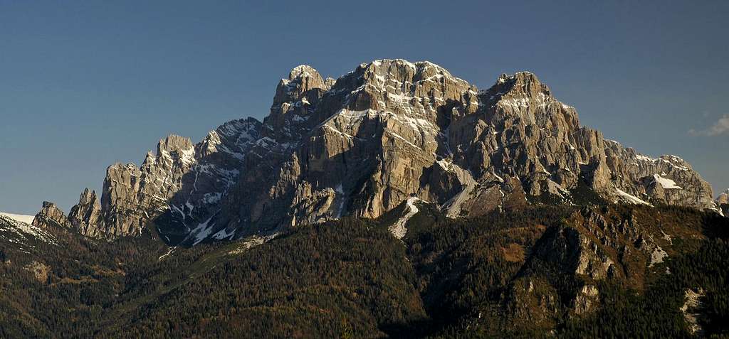
Moiazza group seen from Passo Duran
Moiazza is often considered as secondary importance if compared to the neighbours "Marmolada", "Civetta" or "Pelmo", on the contrary it offers some walls of remarkable majesty as the Castello delle Nevere 2599 m, an imposing wall of pure dolomite, whose imposingness can be observed nearby the village of Listolade. Moreover it hosts several very nice rock towers and walls, and wild valleys rarely visited by alpinists and hikers.
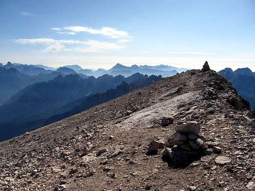
The summit of Moiazza Sud |
An early morning view to Moiazza from Malga la Foca |
The most outstanding part of it, it's certainly the southern, which rises above the village of Agordo, and where the "Ferrata Costantini" permits to discover the finest ridges and the main summit. Ferrata Costantini is also considered one of the hardest Via Ferrata of the Dolomites. As well as numerous routes for skilled climbers inside wild and uncrowded areas and other ones more known and attended, mainly in Masenade-Cantoni dei Duran subgroup, there are also many itineraries for hikers, which allow to appreciate Moiazza from every sides.
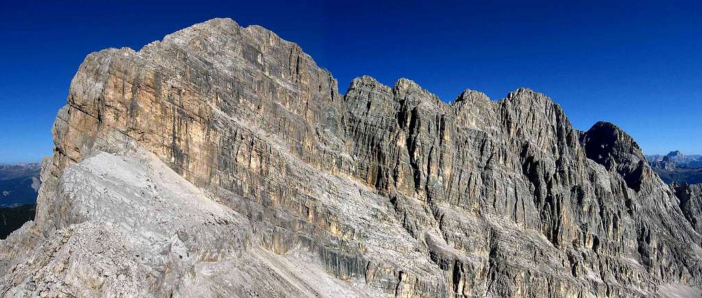
The S flank of Moiazza Southern summit seen from Forcella delle Masenade - Photo andrea
The Moiazza group is crossed by the "Alta Via delle Dolomiti" n. 1, a trail starting from Lago di Braies and ending with the Schiara group. The sector concerning Moiazza includes the path 554 starting from Ref. Vazzoler, crossing Col dell'Ors, skirting the base of Torri del Camp, crossing Van dei Cantoi and getting the Rif. Carestiato. From here the trail proceeds along the forest road to Casera Duran, where on the right there's a marked path leading to Passo Duran.
We can divide the massif in five further subgroups:
Main chain Crèpe della Moiazzetta Masenade-Cantoni del Duràn Cantoni delle Nevère Cantoni di Framònt
Getting there
The sides to approach the massif are three: the West and South ones, above Agordo valley, and the East one above Zoldo Valley.
From Agordo Valley: The Agordo valley is the start point for reach the Moiazza and the south part of Civetta. From "Val Corpassa", which is a secondary valley, it starts the paths directed to the area of Cantoni delle Nevere, Crepe della Moiazzetta, Cantoni di Framont and the Forcella delle Sasse.
Passo Duran is the highest point for the approach of the south side end the "Ferrata Costantini". To village of Agordo, by car(SR203), or by bus from the major cities of Veneto region.
From Zoldo Valley: From Zoldo valley, start the paths directed to the east side of the mountain, and the secondary valley called "Val della Grava", permits an easy rapprochement.
To the valley of Zoldo and the minors villages of Forno di Zoldo and Zoldo Alto, by car(SR251), or by busses from the majors cities of Veneto region.

Subgroups
Main Chain
This is the main section, hosting the highest summits. It runs from North to South, with impressive walls on both the sides. The summits are:
- Cima di Nali 2776 m - Moiazza Nord 2870 m - Torrione delle Nevere 2860 m - Rocchette delle Nevere 2843 m - Moiazza Sud 2878 m
Crepe della Moiazzetta
This is the northern section on the border with Monte Civetta.The summits are: - Cima della Moiazzetta della Grava 2727 m - Cima delle Sasse 2878 m - Col dei Camorz 2489 m - Crepa Alta 2543 m

|

|
Masenade-Cantoni dei Duran
Above Passo Duran. Probably the most impressive, if seen from south. This part hosts the "Ferrata". The summits are: - Cresta delle Masenade 2737 m - Pala delle Masenade 2413 m - La Cattedrale 2558 m - Sass del Duran 2515 m
Cantoni delle Nevère
Southwest part, rising above Val Corpassa. It hosts the bivouac Ghedini. The summits are: - Cima delle Nevere 2621 m - Cimon dei Zoldani 2494 m - Campanile dei Zoldani 2465 m
Cantoni di Framònt
The less important section, placed over the villages of Agordo and Listolade. It doesn't offer any climb and hike interests. The highest point are: - Lastia di Framont 2294 m - Mont Alt 2181 m
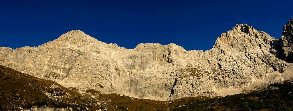
East side seen from biv.Grisetti - Photo andrea
Routes overview and History
Moiazza, as the rest of Dolomites, hosts a lot of different routes. Too many for a precise list. In this page will be explained only the major routes of the Main Chain and the Crepe della Moiazzetta.
Cima della Moiazzetta della Grava 2727m
N ridge: E.Clement, O.Shuster, G.Zecchini 21/07/1904 (1.30h PD)
S ridge: A.Andreoletti, A.della Bianca, G.Pasquali, G.Mezzacasa 19/07/1913 (1.30h F)
Cima delle Sasse 2878m
E flank: C.Tomè, E.Conedera 19/09/1895 (2h PD)
N ridge: F.Steirl, H.Baumgartl 06/07/1935 (2h TD)
SW wall: K.Merk, H.Shneider 17/08/1930 (450m IV/V)
Cima di Nali 2776m
E wall: C.Tome', E.Conedera 22/09/1875 (6h D)
Moiazza Nord 2870m
E wall: S.Sperti, V.Angelini, G.Angelini 15/07/1925 (500m D)
SE wall: A.Piccolo, O.Casellato, F.Verbano 25/09/1966 (550m III/IV)
Rocchette delle Nevere 2843m
Entire ridge from N to S: G.Zorzi 27/08/1942 (4/5h II/III)
E wall: U.Pomarici, G.Fiammengo 15/08/1966 (350m III/IV)

|

|
Moiazza Sud 2878m
Ferrata Costantini: Very hard ferrata (1000m 5/6h EEA)
E wall: G.Zorzi, P.Mason 22/08/1951 (400m IV)
S flank: C.Capuis, G.Angelini, F.Vienna 28/08/1931 (4/5h IV)
S spur: C.Barbier, A.da Roit, U.Benvegnù 09/1961 (700m IV/V)
S wall: U.Benvegnù, R.Conedera 12/07/1964 (600m IV/V)
Red Tape

There are not particular restrictions in climbing and hiking. Moiazza Group belongs to the system "Pale di San Martino, Pale di San Lucano, Dolomiti Bellunesi, Vette Feltrine", which is one of the 9 areas of the Dolomites acknowledged as an UNESCO World Heritage Site.
More info in the article: Dolomites, living mountains by the SP member Silvia Mazzani
Climbing images

|

|

|
When to climb and hike
Best season goes from May to October, infact the low altitude of some towers allows to climb from late Spring to middle Autumn, naturally depending on the snow.
Accomodations
Rifugio Vazzoler 1714 m
Owner: CAI Conegliano
Size: 86 places (10 winter)
Guardian: Bruno Sorarù
Open from 15/06 to 15/09
Phone: 0039-0437-660008
From Capanna Trieste (1,45 hours T).
Rifugio San Sebastiano 1605 m
Size: 30 places
Open: permanently
Phone: +39043762360
Location Passo Duran, from Agordo by car (9 Km.)
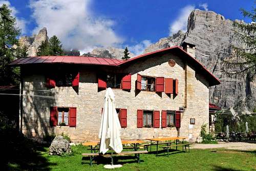
Rifugio Vazzoler |
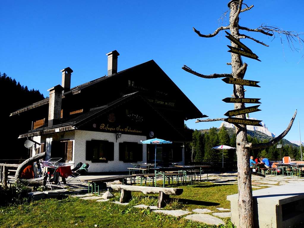
Rifugio San Sebastiano |
Owner: CAI
Size: 30 places
Guardian: Soro Dorotei
Open from middle June to the end of September
Phone: 0039-3464165461
Location Passo Duran, from Agordo by car (9 Km.)
Rifugio Bruto Carestiato 1843 m
Owner: CAI Agordo
Size: 44 places (9 winter)
Guardian: Fam. Diego Favero
Open from 15/06 to 20/09
Phone: +39043762949 +393929746984
From Passo Duran (45 minutes, T).
Bivacco Ghedini 2601 m
Size: 5 places
Owner: CAI Agordo
Open: permanently
Location: Forcella delle Nevere
From Rif. Carestiato (2h EE), or by Via Ferrata (5h EEA).

Bivacco Grisetti 2050 m
Size: 9 places Owner: CAI Trecenta
ù Open: permanently
From Passo Duran (3h E), from Chiesa (3h E)
Meteo
DOLOMITI METEO Phone +390436780007 fax +390436780008
CENTRO VALANGHE DI ARABBA Phone +390436755711 fax 043679319 e-mail cva@arpa.veneto.it
CENTRO VALANGHE DI ARABBA Phone +390436755711 fax 043679319 e-mail cva@arpa.veneto.it
Guidebooks, Maps and useful Links
 |
 |
 |
- Guidebooks
“Moiazza – Roccia tra luce e mistero” 163 itinerari in Moiazza by Stefano Santomaso, Idea Montagna 2011
“IV grado in Dolomiti – Vol. II” by Emiliano Zorzi, Idea Montagna edizioni, 2010
“IV grado e più – Dolomiti Orientali” by Emiliano Zorzi – Luca Brigo – Carlo Piovan, Idea Montagna Edizioni, 2012
“Arrampicate scelte sul versante meridionale della Moiazza” by Soro Dorotei, 1994
"Civetta - Moiazza” – V. Dal Bianco – G. Angelini Tamari Editori in Bologna, first edition 1970, last edition 1984 (Last update in 1970)
- Maps
Kompass 1:50000 n. 77
Tabacco 1:25000 n. 15
Giralpina 1:25000 n. 3
IGM 1:25000 n. 12