
|
|
Route |
|---|---|
|
|
40.23498°N / 115.5406°W |
|
|
Hiking |
|
|
Spring, Summer, Fall |
|
|
Most of a day |
|
|
Overview
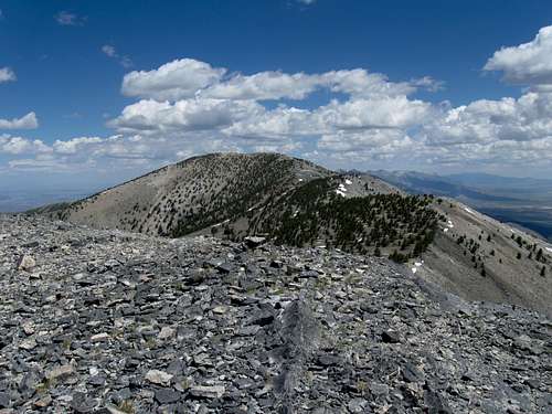
From the top of Peak 10563, this pic shows the route over to Pearl Peak, about 2 miles away at this point. 6-12-13
While you could hike up the east side as was done by the author of this page, there is another way to do this from the west side. That is via Mitchell Creek which can be accessed by driving south out of Elko. It does require a 4WD vehicle with high clearance.
Getting There
Head south from Elko on Hwy 227 and then south on Hwy 228. On paved highway, it is roughly about 32 miles to reach Jiggs, a wide spot in the road with a bar and gathering place for the locals and continued south a few more miles (about 3) where we turned right on a great wide gravel road that continues south on NV road 719 towards the Bald Mtn Gold Mine. The paved road continues to Harrison Pass, but instead we turned right and it was here that Dennis zeroed his odometer (I failed to remember to do so and these are his mileages on his Tundra so your mileage may vary a bit) and we stayed on this good road for 10.4 miles slowing down several times as we passed through some ranches. Leaving the ranches behind, we watched for and then turned left on signed road 57362. The sign is one of those BLM picket like ones so don't be looking for a big sign, this one simply has the number 57362 on it and was located on the right side of the road. We followed road 57362 all the way to where we parked, but there are some forks and turns in the road. I've listed some key waypoints below so you'll find it helpful to use them but I'd strongly recommend that you spend some time on the topo maps to orient yourself to the road system you'll be traveling. At 11.6 miles we stayed left, at 14.1 miles we went left, at 14.4 miles went straight, and at 15.3 miles straight again. At 16.6 miles passed an abandoned rock cabin on the right, at 17.0 miles reached a T intersection and went right. At 20.6 miles reach a water trough on the left and we shifted into 4WD as the road got a bit rougher and yes, high clearance is recommended . At 21.0 miles we topped a ridge and turned left and headed for a road that is cut into the side of the hill ahead of you.There is a great view of another higher ridge and the steep road leading up to it. This higher ridge is at about 9700 ft and we reached it at about 22.9 miles. We drove down the other side of the ridge ( a snow field would have stopped here if we had been a little earlier in the season) and up another still higher ridge to about 10250 ft at 25.3 miles. Cass House Peak is a short distance off to the left at this point. We could see the road continue towards Pearl Peak but could only drive about another .25 mile before we were stopped by snow.
A few helpful GPS waypoints:
Road junction for 57362 (elev 5800') 40.23385 115.7036
WPT at elev 6485' 40.17965 115.6443
WPT at 6840' (take right) 40.1719 115.6193
WPT at 8590' (head north) 40.1527 115.5579 It is at this waypoint where you will see the road climbing up and
heading across the hill in front of you. After it climbs to a saddle, it drops down (this is where we just missed being stopped by a snow field) and
continues into a broad area before it starts climbing up towards Cass House Peak.