
-
 3373 Hits
-
 72.08% Score
-
 2 Votes
|
|
Route |
|---|---|
|
|
69.55979°N / 19.35905°E |
|
|
Mountaineering, Scrambling, Skiing |
|
|
Spring, Summer, Fall, Winter |
|
|
Most of a day |
|
|
Class 3 |
|
|
Overview
This is the standard route on Hamperokken that most parties use. The long ridge traverse is constantly interesting without being too difficult. In winter the lower part of the ridge is a popular ski run.Getting There
Follow directions on main page for parking.Route Description

Middagsaksle on the skyline
Stay on the ridge crest traversing toward the summit. When not possible to stay on the crest, most of the traverses go to the right below the crest, though there is one ledge system fairly early on that is on the left above the north face and is fairly exposed[

The final gendarme before the summit pinnacle is passed on the right. There is more than one ledge to use to ease around this feature, generally, the lower one descends, the easier it is to get around it. I've found the best ledge to be about 40 meters or less from the top.

View of last gendarme and southwest slope

Traverse of the final gendarme
Once this final gendarme is skirted, its fairly obvious how to get up the pinnacle. The wide chute going up the center has a slightly less steep grade, many use the right hand side, and eventually use the right edge for the final few meters before the summit.
In winter, the route is basically the same, though parking is a little more tricky since the main parking area is snowed in. Most skiers will turn around after getting to the ridge crest as the ski descent from here is excellent. .


Essential Gear
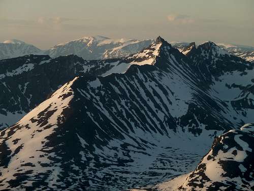
Many summits visible from Tromsdalstind.
Hamperokken in the center foreground. The entire middagsaksle ridge route is visible. It's the long ridge split in sun\shade.
The skyline in the back shows part of the Jiekkevarre traverse. Look from the summit of Hamperokken, behind and just to the left of the summit pinnacle is Holmbuktind. One can see the top of the skiing route. Follow the ramp of snow to the pass, and take a sharp right to get to the summit. From there, continue left to Jiekkevarre, the highest dome. Continue looking left to the gap and onward to Kveita, which is the next dome of snow on the far left edge of the picture.
Also in this photo, in the foreground to the left of Hamperokken is Gabrielfjellet, which is an extension of Hamperokken, but can be considered a separate peak.
The peak immediately to the right of Hamperokken is Bjørnskardalstind (trans. Bear Pass Valley Peak.)
Winter/Spring: Depending on conditions, Randonee or Telemark ski equipment, crampons, ice axe.