
|
|
Mountain/Rock |
|---|---|
|
|
36.35230°N / 50.96170°E |
|
|
14363 ft / 4378 m |
|
|
Overview
NOTES:Menareh means minaret.
Click for Introduction to Takhte Soleyman Massif.
Click for a map of Central Alborz.
Click for a map of Takhte Soleyman Massif.
Click for an aerial photo of Takhte Soleyman Massif.
My GPS/altimeter showed the elevation of this peak to be 14395 ft (4387 m). The 4378 m figure is per the 1:50 000 map listed below.
OVERVIEW:
One of the most awesome peaks of the Takhte Soleyman Massif!
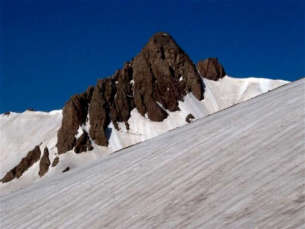
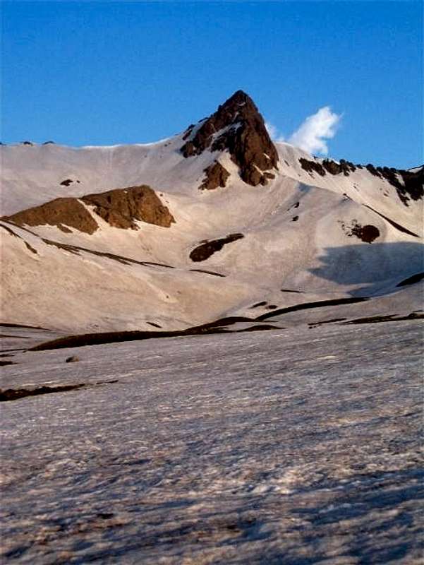
Menareh may not be one of the highest peaks of the Takhte Soleyman Massif but it sure is one of the most impressive ones. This mountain sits in the southern portion of the massif and rises 375 m (1250 ft) above the tail end of the Khersan Glacier. The top 150 m (500 ft) of it form a big horn, the east face of which is a near vertical wall. The rock that the horn is made of has a reddish/orange tinge causing the mountain to glow brightly under the light of the early morning sun. In an otherwise white and blue (snow and sky) environment, the viewer is mesmerized by this orange giant who is both the beauty and the beast.
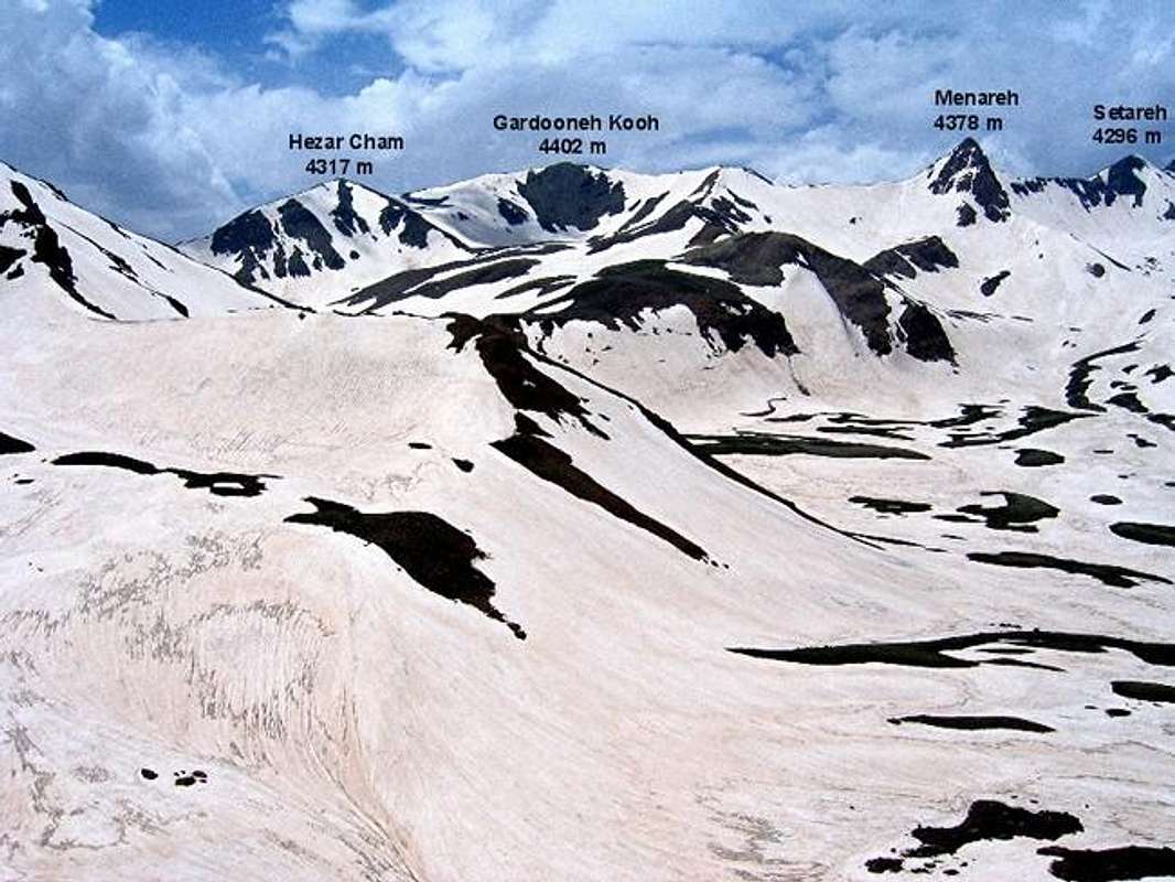
Menareh is most readilly accessible from Hesar Chal, a roughly circular plain with an approximate diameter of 1.5 km (one mile) in the southern portion of the Takhte Soleyman Massif. Hesar Chal is gently sloped, drains to the east and is 3600-4000 m (11800-13100 ft) high. To the north, Hesar Chal leads to the valleys of Khersan and Marji Kesh Glaciers. The main spine of the Takhte Soleyman Massif forms a continuous lines of peaks to the west and south of Hesar Chal. Although Gardooneh Kooh is the highest of these peaks, Menareh is the one that attracts the most attention.
Menareh can obviously offer technical route opportunities to those who seek it (any technical information is most welcomed). The easiest route, however, is class III requiring "hand and foot climbing" only at the very top. The starting point is the village of Roodbarak (elevation 1400 m, 4700 ft). From Roodbarak, you will hike up the valley of Sardab Rood River to Hesar Chal. This hike will take you past beautiful meadows that in early summer are covered with wild flowers. Snowy peaks provide dramatic backgrounds for these meadows (PIC1, PIC2, PIC3, PIC4). Just below Hesar Chal, the valley becomes narrow. This area is known as "Tange Galoo" (literally translates as "Throat Narrows"). Frequent winter avalanches create huge piles of snow that remain here year round (PIC!, PIC2).
Hesar Chal is an ideal place for overnight camping because it can provide quick access to many of the nearby peaks including Alam Kooh. When we were in Hesar Chal in late June, most of it was still covered with snow. By mid summer, flowers and grasses come to replace the snow. Menareh dominates the view from Hesar Chal. It can be climbed in combination with Gardooneh Kooh Peak (see Route for detailed info). From the top of Menareh, you can look down to see the lower end of the Khersan Glacier 375 m (1250 ft) below your feet. The southern slopes of Alam Kooh and other jagged peaks that surround the Khersan Glacier will also be in good view.
Please note that continuing north from Menareh to the Setareh Peak can present a problem to the hiker (see Route).
Getting There
See Map.From downtown Tehran drive 40 km west to the town of Karaj and take the Karaj-Chalus Road north (This road crosses the Alborz Mountains taking you through the Kandovan Tunnel to the Caspian Coast). 30 km south of Chalus, you will reach the town of Marzan Abad. Turn left and follow a side road into the Sardab Rood River drainage and to the town of Roodbarak. Distance from Tehran to Roodbarak is roughly 200 km (125 miles)
 |  |  |  |  |
Red Tape
I am not aware of any permit or fee requirement. Hunting will require a license. |  |  |  |  |
When To Climb
June to October is the ideal season. Climbing in winter will obviously be much harder due to extreme cold and heavy snow cover. |  |  |  |  |
Camping
Accommodations are available at the Iran Mountaineering Federation Hotel in Roodbarak (call Mountaineering Federation at 98 21 8839928) or camp anywhere.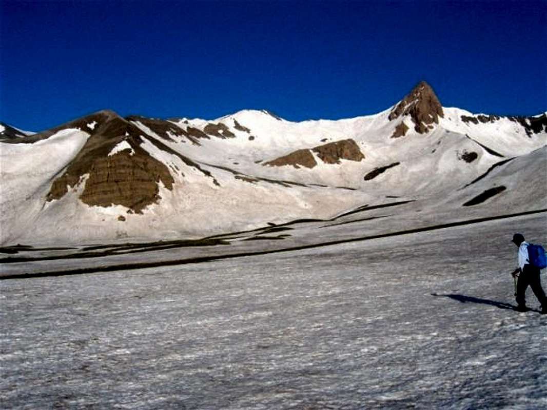
Mountain Conditions
In summer, the weather is generally clear. Unexpected thunderstorms do occur frequently. Precipitation at higher elevations will almost always be in the form of snow/hailMiscellaneous Info
TOURS/GUIDES:If you are not familiar with these mountains, you will greatly benefit from the presence of a guide. I worked with Araz Adventure Tours and was very satisfied with their services. They were flexible, courteous and knowledgeable and were able to custom design an 8 day trekking tour allowing me to climb the lesser known peaks of the area. My guide: Mr. Rasool Naghavi was a kind man who was a native of Roodbarak and knew the mountains like the back of his hand. Having climbed Everest and several other Himalayan giants made him, in my opinion, one of the most qualified guides for these mountains.
MAPS:
1) The most accurate topographical maps of the area are those with a scale of 1:50 000 (contour lines of 20 m) provided by the Iranian Armed Forces. You will need sheet #6162 I "Shahrestanak" for Menareh and Alam Kooh (To fully cover the entire Takhte Soleyman Massif, you will also need sheet #6262 IV "Rudbarak"). These maps are available in Tehran at the Geographical Office of the Armed Forces on Moalem St. (98 21 8408088) for the equivalent of $3 per sheet (in 2004). Outside of Iran, the same maps can be purchased at www.cartographic.com for the exorbitant price of $150 per sheet (in 2003). These maps are in Farsi. While they give the exact elevation of most of the peaks, they do not give the names of the individual peaks.
2) Soviet Military Maps sheet # J-39-126-G available at www.omnimap.com. I do not recommend this map. It seems as if the creators of this map lacked detailed info and eliminated many of the lower peaks.
3) Different schematic maps available in Iran. My favorite is the "Guide Map of Takht-e-Soleiman & Alam Kuh Region" by Iran Kuhro Co. available at Varzesh Kooh store, Ferdowsi Sq., Tehran (98 21 8826642).
Damavand - Nov 9, 2004 2:04 pm - Hasn't voted
Untitled CommentA photo of Menareh peak and Hesar-Chaal valley