
Comments
No comments posted yet.
|
|
Trip Report |
|---|---|
|
|
50.12557°N / 114.27081°W |
|
|
Jun 29, 1993 |
|
|
Hiking |
|
|
Summer |
Mauna Kea - 50th Birthday Challenge: 50 Miles to the Highpoint of the 50th State—Hawaii
Thomas P. Martin*
The original source for this article is Future Focus, Ohio Journal of Health, Physical Education, Recreation, and Dance, 16:1:10-14, Spring/Summer, 1995.
*Thomas P. Martin, Ph.D., FACSM, is a Professor Emeritus in the Health, Fitness and Sport Department at Wittenberg University, P.O. Box 720, Springfield, OH 45501. He has completed 49.8 of the 50 U.S. State highpoints. He has also been "physically active" in all 63 U.S. National Parks, has experienced 422 of 423 National Park Units, and has visited 124 of 129 National Monuments.
This web page revised and updated: June 29, 2021
Web Page - https://www.wittenberg.edu/academics/hfs/faculty/martin.html
Introduction
June 29, 1993, would be my 50th birthday. Why not mark this "over the hill" milestone with a personal challenge?! For several years now, I have been working on a U.S. highpoint project. Highpointing involves traveling to each state, finding, and standing on its highest natural elevation. Jerry Wagener, the 14th individual to have completed all 50-state highpoints, introduced me to highpointing. He and his son Jeff (13th completer) had hiked 30 miles sea-to-summit in one day up the north side of Mauna Kea to complete their 50thstate highpoint in 1990.
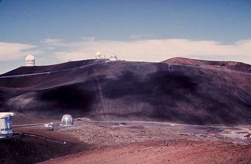
Mauna Kea, at 13,796 feet, is the highpoint of the 50th state and is located on the island of Hawaii. When measured from its ocean-floor base, Mauna Kea is recognized as the biggest mountain in the world. Mauna Kea is also considered the finest astronomical site in the world and contains the world’s most powerful telescopes.
The Wageners' feat gave me the idea of trying to complete 50 miles from sea-to-summit on my 50th birthday. I purchased the relevant topographical maps from the United States Geological Survey (USGS) and started to plan the route and logistics for this challenge. In examining the details, I felt it would be too difficult for me to complete 50 miles and 13,796 vertical feet in one day on foot. As a result, I decided to cover half the elevation by bike and half by boots. My original plan called for a six-day trip including three days for acclimatization on the mountain.
As I worked on logistics, it became clear that support would be very helpful for this venture. What better support could I have than Helen, my partner for life? June 8th, 1993, would be our silver wedding anniversary. Why not have a second honeymoon in Hawaii?! "Helen," I said, "think Hawaii; the name rings of excitement and tropical pleasure." "Tell me more," was her response. I explained the wonderful experience of camping out high on a pacific island and driving a high-tech vehicle into the clouds while dispensing exotic drinks and nutritious snacks. For some reason, this marvelous proposition did not match Helen's view of a second honeymoon. It was evident that compromise was in order. We would make it an eight-day trip, two days traveling, three days on the water and three days on the mountain. We made reservations for the last week of June 1993 and I began training for the birthday challenge.
Arrival in Hawaii
We arrived at Keahole airport at 4p.m. on June 23rd, 15 hours after leaving Dayton, OH. We spent our first three days in Kailua-Kona, where Helen made several SCUBA dives. I went out twice and snorkeled with the divers and then spent the third day on a training ride from the ocean to the top of Kaloko Dr. (21 miles and 5,000 foot elevation gain) on Mt.Hualalai. These were fun relaxing days with plenty of sun and good food.
Day 4 was to be spent acclimatizing at 9,000 feet and Day 5 at 13,000 feet before the climb. The camping gear was ready. However, I had second thoughts that primitive camping at altitude would detract from "our" anniversary celebration. As a result, we decided to keep our room in Kona and drive to Hilo the night before the climb. This meant that I would have no sleep the night before the climb and would not be acclimated to the altitude. When I was in graduate school, I participated in a study, which showed that there was no decrement in physical performance of short duration (e.g., muscular strength and maximum aerobic capacity) with short-term sleep deprivation. Therefore, I rationalized that my performance (muscular and cardiorespiratory endurance) on the mountain would not be affected by missing a night's sleep (NOT!).
On Day 4 we scouted the route on Mauna Kea, taking pictures and mileage readings from the top down to the starting point outside of Hilo to be sure that the route was at least 50 miles long. It was a beautiful day and the only day during our seven-day stay when we could see the top of the mountain. Headaches from the altitude were an ominous sign of likely difficulty on the day of the climb.
After dinner in Hilo, we decided to visit Hawaii Volcanoes National Park, where the lava was flowing from vents on Kilauea and into the ocean. This was supposed to be an early evening for us so we could get a good night's rest; however, the reports from the volcano were just too tantalizing. A night hike took us to a point where the lava was actually flowing under our feet and oozing from small domes only a few feet away. It was spectacular as small flames vented from the cracks in the hardened surface lava on which we were walking. A three-hour drive got us back to Kona at 2 a.m.
After four hours' sleep, we were up again for Helen to take her morning swim. We rented a kayak so I could accompany her as she swam across the bay to the pier and back—about a mile. On previous days she had swum about a half mile to the anchored dive boat Na Pali Kai II with Captain Jeff Leicher of Jack's Diving Locker. Jeff was training for the annual mile swim competition to take place in Kona Bay the following week. We spent the rest of Day 5 relaxing, carbo-loading, packing, and preparing for the climb the next day.
We left Kona at 9 p.m. and followed Rt. 190 and Rt. 19 around the north side of the island to Hilo. It rained hard during the last half of the trip, and we wondered if it would be possible to take pictures at the starting point. As I bounced around the jeep, I thought, "It's a mistake to start this thing without any sleep and with only four hours of sleep the previous night. It would have been best if I had acclimatized and then spent the evening before the climb in Hilo. Oh well, what's done is done, do as best you can, and go for it."
Taking Off
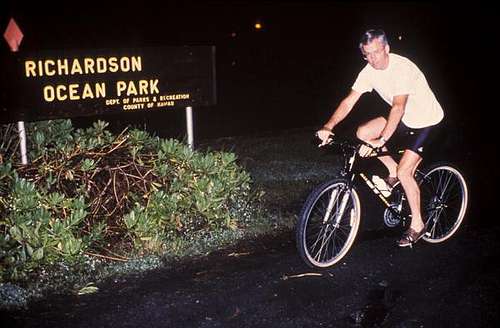
We arrived at Richardson Ocean Park outside Hilo at about midnight. The plan was to start "early" to avoid Hilo traffic, to minimize high temperatures and sun, and to provide more total hours for making the summit on my birthday. After a warm-up of five 50-second stretches, 50 push-ups, 50 sit-ups and 50 jumping jacks (to go along with the 50th birthday theme), I placed my all-terrain bike in the ocean and was ready to go. Helen took a few pictures, and I was off on my adventure at 12:15 a.m. on June 29th.
It had just stopped raining and was pleasantly cool as I pedaled through Hilo. I followed Kalanianaole (Rt. 19) for three miles, made a left turn and followed Kanoelehua (Rt. 11) for two miles to Puainako where I turned right and then right again onto Kilauea Avenue to the center of town. The intersection with Waianuenue was the 7.6-mile mark. The miles to this point, which is near the ocean, were needed for the distance to equal 50 miles. I stopped to change shoes and then started the grade up the mountain. Waianuenue becomes Kaumana and then Saddle Road (Rt. 200) as it proceeds "Mauka" or toward the mountain.
I passed Kaumana Cave (elevation of 560 feet) at the 10-mile mark after an hour of pedaling. My plan was to conserve energy by moving slowly, thereby—hopefully—preventing fatigue later in the day. Gatorade donated three boxes of its Performance Series liquids, which I used for carbo-loading, to maintain hydration and electrolytes, and to provide some energy. The objective was to start and finish on my birthday. How fast I completed the 50 miles and reached the summit was not important.
I continued up the winding road through lush vegetation until about 4 a.m. (3,700 feet), when it started to rain. I took a half-hour break and put on my Gore-Tex pants and jacket. Riding was no longer fun. After another 5 miles (1,300-foot elevation gain to 5,000 feet), I started to question my sanity. Morning had arrived, I was tired and wet, had a sore bottom, and was starting to feel the altitude. It was time for a major break—would I continue?
As I rested in the jeep, I thought, "Hey, I could be at the beach, relaxing at the pool, snorkeling in the ocean, or sipping a Mai Tai on a cruise." I came very close to just packing it in. After a two-hour rest, I decided on setting a goal of reaching mile marker 25 (for our 25th anniversary) on Saddle Road (32.5 miles). I covered the next 6 miles in an hour and a half, riding through heavy rain and gaining 1,150 feet in elevation. It was now 9:15 a.m. (6,150 feet) and traffic was fairly regular on the road.
Saddle Road gets its name by passing through the "saddle" between Mauna Loa (13,680 feet) and Mauna Kea (13,796 feet). It's a two-lane road, but only its center is relatively smooth. Every time a car or truck would pass, I would have to ride the broken pavement at the side of the road. Helen would alert me to approaching cars by flashing her lights or blowing the horn. She also shouted me encouragement and occasionally drove next to me when there was a good song on the radio.
After a 15-minute rest, I decided to proceed to the Mauna Kea turn-off of Saddle Road and see how I felt. I covered the next 3 miles in a half-hour and arrived at the turn off at 9:45 a.m. (6,480 feet). I spent 45 minutes for lunch.
My next goal became reaching the 7,240 foot-level on the mountain, where I knew there was a significant increase in grade. The rain was now blowing horizontal to the ground and across my path. When she could, Helen would bring the jeep alongside to protect me from the wind. There was more traffic on the road than we had expected due to the construction of new observatories on the top of the mountain.
The Hike
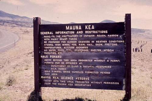
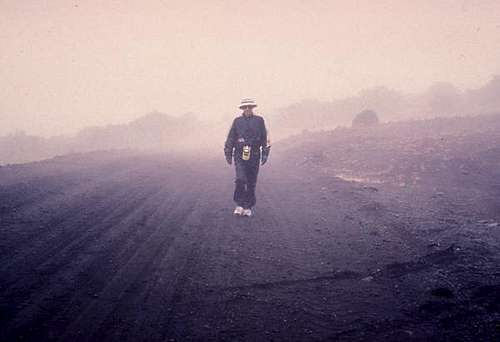
I stashed the bike in the jeep after 38.4 miles and a 7,240-foot gain in elevation and began to hike. My next objective became reaching the Onizuka Visitor Information Station (VIS), named in honor of Air Force Lt. Col. Ellison S. Onizuka, a native of Hawaii, who lost his life in the space shuttle Challenger disaster in 1986. It took me two hours to cover the next 3 miles and 1,800 feet. It was Tuesday, so this "Center for International Astronomy" was not open; however, the restrooms were available and were much appreciated. When we had stopped at the VIS two days earlier (open on weekends), we found it interesting that "Children under 16 are not allowed on the summit tours due to potentially severe health hazards for young people exposed to high altitude."
The asphalt road ends above the Visitor Center and a sign reads that only 4-wheel drive vehicles are permitted beyond this point. Heavy fog and mist now covered the climb and it was important to keep the jeep’s emergency flashers working to alert the construction trucks moving to and from the observatories of our presence on the road. As I moved up the road, a suburban with about seven workers stopped to ask Helen what I was doing. They had seen me on the bike that morning and were wondering what was going on. When she explained, they just shook their heads, continued drinking their beers and headed down the mountain.
Hitting the Wall
I continued up the road at about 2-mph until I reached 46 miles (11,120 feet). At this point I "hit the wall." The next mile took an hour! A combination of depleted energy stores, altitude, and fatigue made continuation extremely difficult. It was 5:15 p.m., and I had a little more than 3 miles and 2,126 feet in elevation to go. Helen, who was previously supportive, was now suggesting I give up the quest. My pace had slowed to a crawl. I was struggling and obviously in pain. But it was "only" 3 more miles! Could I give up after having come so far? After a 15-minute rest, I decided to plod on in heavy rain.
I was now on the newly paved road that continues all the way to the observatories. A Paradise Safaris tour vehicle stopped and asked if we needed help. They provide the only commercial tour that allows clients to hike to the summit from the observatory parking area. The tour leaves Kona at 3:30 p.m. to try to catch the sunset on the top of the mountain. The guide kindly offered to share some oxygen, but I declined. It took three-and-a-half hours to cover the 3-plus miles to the end of the road. It became a matter of putting one foot in front of the other (baby steps on the steep grades) with several rest stops along the way. The altitude continued to have its impact, and I added to the mass of the mountain (i.e. deposited the last several hours of food intake) at the 13,000-foot level (49.3miles).
Reaching the Top
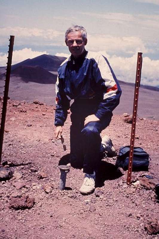
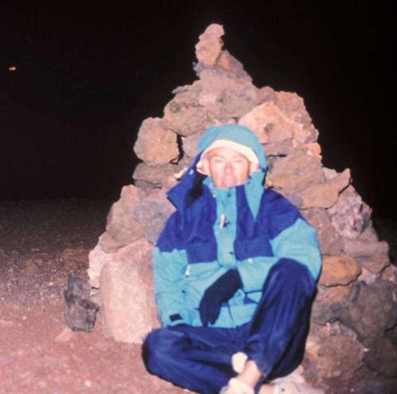
Darkness and cold greeted me by the time I reached the top of the road (50.3 miles). The weather had cleared and the final 0.2 of a mile involved a scramble down a cinder slope and up another to the 13,796-foot highpoint. Helen opted not to go because we didn't have flashlights, and it was difficult to see the route. "Besides," she said, "I've already been there!" (She was referring to when we scouted the mountain two days earlier.)
I grabbed the camera and tripod and moved off into the night. I reached the summit at 9:00 p.m. The quest was over. I set up my tripod near the USGS benchmark and took a picture of myself sitting next to the summit cairn. For some reason, I didn't feel the sense of accomplishment I thought I would. This was supposed to be the point where you shout for joy and bathe in the reality of your achievement. Perhaps I was just too exhausted. Sometimes, I’ve found that the joy of such an accomplishment is delayed by a few days and a return to body homeostasis.
Hiking the final cinder slope on the way back to the road was very taxing. After reaching the jeep, I made another deposit (what a way to clean out the GI tract!) and then gathered myself for the trip down the mountain. My body did not appreciate the significance of this accomplishment. It was now 21 hours since I started--toes and tires in the surf. In my planning, I had estimated a 15-hour day including two hours of rest. As it turned out, I had had about five hours of rest during the day, which meant I covered the 50.5 miles in 16 "moving" hours. The elevation gain of 13,796 feet was equivalent to 2.6 vertical miles or 5 Burj Khalifas (the world's tallest building in Dubai UAR at 2,717 feet) stacked one on top of the other.
The 3-hour drive back to Kona was the most dangerous part of the trip. It became my job to make conversation to keep Helen awake at the wheel. We both had had only four hours' sleep over the past 64 hours. My eyes were continuously closing, and I had trouble focusing (visually and mentally) on anything. We now appreciated the poor condition of Saddle Road as the jolts from the broken pavement helped to prevent a lapse into dreamland. The middle and shoulder reflectors imbedded in Rt. 190 served the same purpose as the jeep occasionally strayed out of its designated lane.
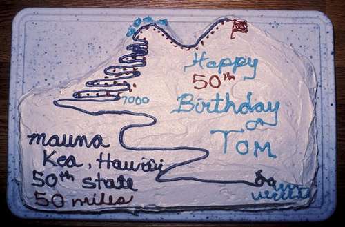
We arrived back in Kona a little past midnight, locked the jeep, went to our room, and "crashed." The six o'clock alarm reminded us of the need to clean and pack before our departure flight. What a birthday! Helen promised a birthday cake reward with the family when we arrived home.
Why Highpoint?
Why did I do it? That's the ubiquitous question. Because it was there? Because AARP had sent me a membership card? Because I sought some sort of notoriety?
No, I did it just for me. That may sound selfish, but it's true. The vast majority of my time is spent providing for my family, fulfilling my work responsibilities, and serving my profession. This challenge and my other outdoor activities are purely self-indulgent.
There is a complex interplay of reasons that may explain my motivation. First, communing with nature by physically participating in the beauty and awesome simplicity/complexity of the environment is a spiritual experience. Words cannot express the profound feelings that accompany the mind/body/nature experience. This is the "core" of life.
The personal challenge is also a motivating force. What am I capable of? What are my limits?
Other major reasons include the maintenance and development of mental and physical health. For example, stress reduction, excitement, and enhanced self-image are positive outcomes. Sharing with others, learning through travel, and creative expression by way of diary and scrapbook provide additional mental benefits. Physically, a regular exercise routine and training for specific outings operate to maintain healthy body function.
Finally, it's fun! Preferably, this enjoyment will be realized during the activity; however, if that is not the case, one can be sure that the vast majority of experiences will be sweet upon reflection. I can assure you—this one was!
Highpointing Information
Highpointing is an excellent activity for individuals of all ages. Planning and then traveling to state highpoints involves healthy outdoor recreation with concomitant learning of state and regional geography and history. It's great fun, and can be a terrific personal or family project. Some state highpoints can be done in a car as "drive-ups," some are easy hikes, others require cross country travel, and some involve climbing with considerable exposure or travel on glaciers where ropes are required.
For further information on highpointing, go to the following site: