
-
 5487 Hits
-
 86.85% Score
-
 23 Votes
|
|
Route |
|---|---|
|
|
44.57450°N / 6.85203°E |
|
|
Sport Climbing |
|
|
Summer |
|
|
Most of a day |
|
|
TD sup., UIAA VI+, French 6a+ |
|
|
5.10a (YDS) |
|
|
6 |
|
|
Overview
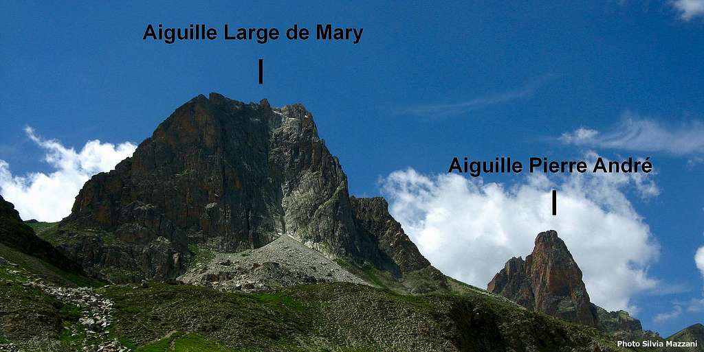
Marmottes Givrées
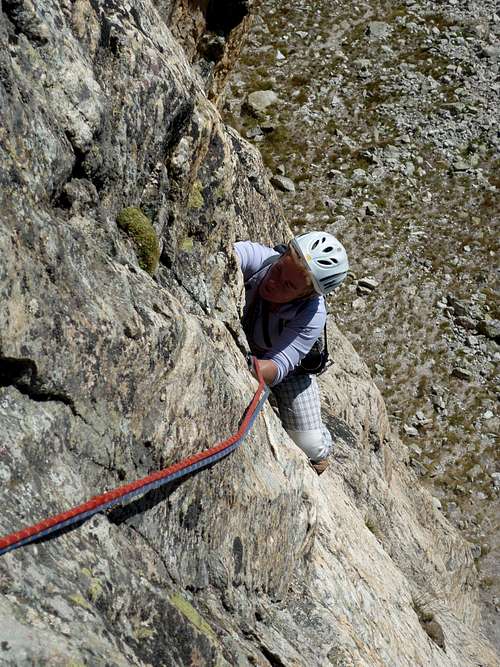
Aiguille Pierre Andrè is considered as the Aiguille Dibona of Ubaye. Albeit not so superb and flashy, it's a beautiful and slender spire, whose South-South-East wall shows an excellent quartzite with a strong orange color, and very rich in handholds, that facilitate the climb always extremely steep. Four routes are located on the face, but the most interesting and frequently climbed is without any doubt Marmottes Givrées, a magnificent steady route on extra quality orange quartzite leading directly on the summit. A little masterpiece! The climbing style is athletic and varied, demanding a good training on 6a grading. The route is short - 6 pitches - but the fine climb surely compensates the length of the approach (about 2 hours from Maljasset).
Getting There
Road approach
The main towns in the area are Barcelonnette and Guillestre.
- From Barcelonnette follow the road D902 along the Ubaye Valley towards Saint Paul sur l'Ubaye; getting to Saint Paul, leave the road D902 and follow on the right the road D25 crossing Saint Paul, continuing up the valley and getting to the small hamlet of Maljasset m. 1905 - Parking before the village.
- From Guillestre follow the road D902 rising to Col de Var, then descending to Saint Paul sur l'Ubaye; getting to Saint Paul, leave the road D902 and follow on the right the road D25 crossing Saint Paul, continuing up the valley and getting to the small hamlet of Maljasset (mt. 1905)- Parking before the village.
Walking approach


Cross the little village of Maljasset m. 1905, then cross the river and take a good path rising along Mary Valley. At the second grassy terrace leave the trail to Col de Mary and follow on the right the "11° BCA Path", a narrow trail with several hairpins leading below Pierre Andrè South face (2 hours from Maljasset).
Marmottes Givreé report
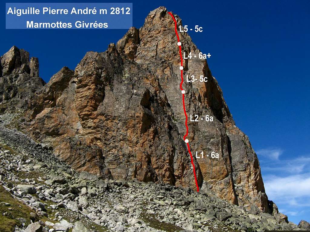
Marmottes Givreé report
***Marmottes Givreé report (French Scale)
Summit altitude: 2812 m
Difficulty: TD, French 6a+ max, UIAA VI+, YDS 5.10a
Equipment: bolts
Length: 200 m
Exposure: SE
First ascent: Jean Pierre Chevalier - Gerard Fiaschi 1994
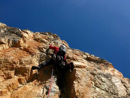
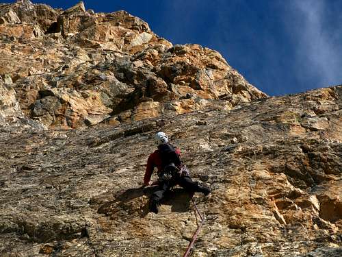
An omogeneous superb climb on steep walls and slabs along a direct line. The quality and the colour of quartzite are extraordinary, the route is truly a little masterpiece!!! Probably the best route to climb the Aiguille
L1 6a Climb a steep pillar on the left of a dihedral, a little overhang, then a slab
L2 6a Magnificent long pitch. Slanting right climb a lightly overhanging wall with good holds, another little wall, then a little corner and a slab.
L3 5c A bit easier pitch. Climb a slab on the left of the edge of the pillar.


L4 6a+ After an overhanging crack (crux), exit left on a narrow ledge, then up a vertical corner. Climb a little overhang and exit on a terrace. Belay above the terrace.
L5 5c+ Up a crack on the left of the belay, then climb a vertical orange pillar on good holds. Three subsequent little walls lead to a slab. Belay.
L6 3b Climb the slab, reaching a ledge. Follow it towards right and with a last easy climb on a wide crest reach the top.
Descent: following the Normal Route situated on the opposite side (little West face, II and III grade UIAA, 80 m.). From the summit head towards SW, downclimbing along an easy ramp and getting the first rappel anchor. After a 30 m. rappel, reach a ledge and a terrace where is located the second anchor. Do another 45 m. rappel, getting to a col at the bottom of the little W face. Descend along the South slopes reaching the approach path.


A curiosity: the name of the route - Marmottes givreè - means "greed marmots"; the name is due to the particular voracity of the local marmots, which sometimes also eat the backpacks!!! A good advise: don't leve any objects at the base of the route and hang your bags to the first fix, high above the ground!
Red tape

There are no particular restrictions in climbing and hiking. Cars in Maljasset village are not allowed. Park in the parking-lot before entering the village.
Essential Gear
Ropes 2 x 50, ten express, helmet
Where to stay
There's an equipped camping open in summer in Saint Paul sur l'Ubaye. In Maljasset' village you can stay in:

- Refuge CAF Maljasset (French Alpine Club - CAF, mt. 1905), 60 beds, always open, phone 04 92 84 34 04 - Gite d’etape “La Cure”.
- Maison d’hotes “La Posada” in Pont d’Estreche
When to climb
Best season goes from middle June to September
Meteo

Guidebooks and maps


"La grimpe en Ubaye" by Colin Michel CAF "Alpes du Sud Provence" by Hervè Galley
Map IGN TOP 25 3538 ET, Aiguilles de Chambeyron