
-
 17304 Hits
-
 83.69% Score
-
 17 Votes
|
|
Mountain/Rock |
|---|---|
|
|
41.49400°N / 106.2537°W |
|
|
Carbon |
|
|
Hiking |
|
|
10246 ft / 3123 m |
|
|
Overview
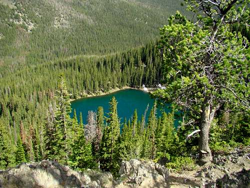 Crater Lake
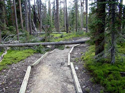
For those who have the privilege to spend a few days in Wyoming’s Snowy Range, a hike worth considering is the Crater Lake Trail on Lookout Mountain. Lists of John gives Lookout Mountain 256 feet of prominence, and the rise from the trailhead to the actual summit is pretty close to the same. The trail gently ascends up the mountain about 1.5 miles to just south of the summit area, which is almost level. To get to the actual summit requires a little off-trail bushwhacking north through the pine forest. This whole region is suffering from pine beetle problems, and you will certainly encounter many fallen trees. Extra caution is warranted for hiking on windy days. The forest service trail workers have more work than time allows for, due to the pine beetles and forest fire damage in the Snowy Range. At this altitude, it normally takes until well into June for all the snow to melt, so be prepared for snow and/or shallow pools of water in some places, if your hike is any time before July. For anyone who wants to do more than to just reach the summit, the trail continues and drops around 600 feet down to Crater Lake through a set of switchbacks. There are great photo ops at the rocky point just to the west of the trail where it begins the steep descent. The color of the lake on a sunny day is well worth the whole hike. Hikers might also be treated to views of wildlife in the area. Besides the plentiful deer, there are elk, moose, bears, mountain lions, foxes, bighorn sheep, and pronghorn antelope. For anyone planning to stay at the lake for a while, fishing for brook trout is an option. Lookout Mountain lies on the west-northwest side of the Deep Creek-Rock Creek canyon, one of the deepest and largest canyon systems in the Snowy Range. The south slope of Lookout Mountain drops sharply over 1,000 feet to Deep Creek, via Crater Lake. There is a trail from Crater Lake that goes down to the Rock Creek Trail. The Rock Creek Trail runs 11 miles from Sand Lake to the trailhead near Arlington.
Getting There
 Trail Hurdles
Perhaps the shortest route from a highway would be from Arlington, Wyoming, located on I-80. From Arlington, take exit 272 and follow Road 111 south for about 12 miles, until you come to Road 113. There will be a sign there to turn to go to the Crater Lake Trail. This will take you about 1 mile, over Carlson Creek and past a little camping area with an old wood outhouse. Just up the road you will come to the Crater Lake trailhead and parking area. A word here on maps… There are “VIP” maps everywhere for tourists in this area. That map shows two trails to Lookout Mountain, calling one the Lookout Mountain Trail and the other the Crater Lake Trail. Topo maps only show a trail and an old road - FS113.g. A check with the forest service trail crews in Saratoga, Wyoming revealed that to be the actual case. FS113.G is sort of like a second trail on the mountain. But, it is not anything they recommend. It is just an old 2-track just south of the Crater Lake Trail. It starts at the back of a little campsite a few hundred yards down Road 113. The road is barricaded to traffic, but winds through the forest and some meadow before just ending near the drop down to Crater Lake. You can get good forest service maps from either of their offices in the area.
Route Information
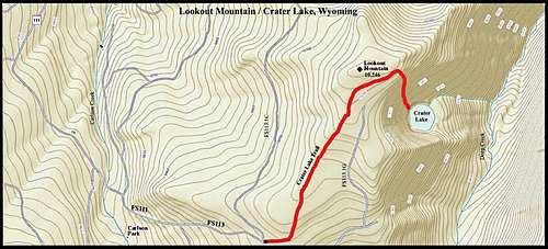 Lookout Mountain & Crater Lake Route Map
Lookout Mountain & Crater Lake are shown on the Sand Lake USGS Quad Maps. The Crater Lake trailhead is located along Forest Service Road 113, about one mile past the junction with Forest Service Road 111. There is a sign at the trailhead, and the trail is well-defined, though you may encounter fallen trees across the trail in some areas. It is about 1.5 miles to the summit area, and you will need GPS to find the exact location of the summit highpoint. The trailhead elevation is just under 10,000 feet, so your gain in elevation to the summit will be about 250 feet. The summit area is kind of flat and heavily wooded. This map will give you a general idea of the route and area.
When to Climb
In this area of Wyoming, heavy snow is possible from October through April. Winter hikes will only be possible when Road 111 is open. Summer lightning is also a consideration when planning your trip. You can check the latest weather conditions and forecast for the area by clicking here: Lookout Mountain - Arlington, Wyoming Weather
Red Tape
 Trailhead Sign
Because of the great risk of forest fires, perhaps the chief concern in this region is campfires. Be sure to check with the ranger district before planning any camping, to be informed of any emergency restrictions or closures. As always, visitors are reminded to pack out what they pack in. For more information from the National Forest Service on area camping and regulations, please visit the link below: Medicine Bow-Routt National Forest Camping Information
Camping and Information Resources
 Deep Creek
Deep Creek Campground is the closest site to Lookout Mountain, though there is a primitive campsite by Crater Lake.
For other area information, check out the links below:
Brush Creek/Hayden Ranger District (307)326-5258
Laramie Ranger District (307)745-230
Laramie Chamber of Commerce (307) 745-7339 or (866) 876-1012