-
 10576 Hits
-
 0% Score
-
 0 Votes
|
|
Route |
|---|---|
|
|
33.85636°N / 116.57929°W |
|
|
Download GPX » View Route on Map |
|
|
Hiking, Mountaineering, Scrambling |
|
|
Winter |
|
|
A long day |
|
|
Class 4 |
|
|
Very Strenuous |
|
|
![]() Overview
Overview

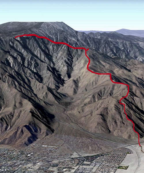
Leatherneck ridge takes you up from the desert floor in palm springs, to either the tram station or on to the summit of San Jac. Heard the name came from a group of marines that had to be rescued from the ridge..hence the term "leatherneck".
The ridge is directly west and runs parallel to tram way road No trail to follow, so in my opinion, a much more explorative route than C2C. Awesome views the whole way up, especially of the east side of falls creek.
From the car to the Tram station we clocked in at 9.95 miles @13:36 with total elevation gain of 8,368 ft.
Much more fun to do in winter, as the upper reaches of the route have plenty of ice and snow to scramble through which makes the route considerably more difficult.
Getting There
Head down Highway 111 into palm springs and make a quick a left on W Rafael Dr., and park as soon as you can. Walk over to 111, cross and head across the desert floor to the base of the ridge where the route starts. We managed to find a rocky road than ran parallel to tram road and the ridge...followed that until we found a suitable spot to start the climb up.
Route Description
Route is very straight forward, you would have to be a very special one to get lost. Just stick to the ridge and head up..
First 5000 ft are hot and.. Alot of up and downs, managed to see some deer.
Around 5500 ft the bleak desert views turns to the much more pleasant alpine scenery
7700 ft you get nice views of falls creek and the north face of San Jacinto, This is where the ridge will narrow greatly and knife edge at times. From here on you will often scramble up and down the ridge.
Crux is last portion of the ridge before topping out into the valley. Much 3rd/4th class scrambling over large boulders that during winter time become very icy. Good spot to use crampons if you got them.
Ridge tops out at 8600 ft.
From the topout head east, (you will be skirting just below a ridgline), and you will stumble upon the long valley trail which will take you to the tram station.
other options are
1. From the long valley trail to head up the summit of San Jac
2. From the topout of leatherneck ridge, to head west, skirt the ridgline and hit Cornell, Miller, and then San Jacinto.
Essential Gear
We did this in December, and brought along ice axe and crampons, which where definitely needed towards the top. No rope or pro needed. No water fillup until Long Valley, so pack plenty.
External Links
Add External Links text here.
Table of Contents