
-
 5513 Hits
-
 81.84% Score
-
 14 Votes
|
|
Area/Range |
|---|---|
|
|
47.09839°N / 11.02825°E |
|
|
Hiking, Mountaineering, Mixed, Scrambling, Skiing |
|
|
Summer, Fall, Winter |
|
|
10810 ft / 3295 m |
|
|
1 - Overview
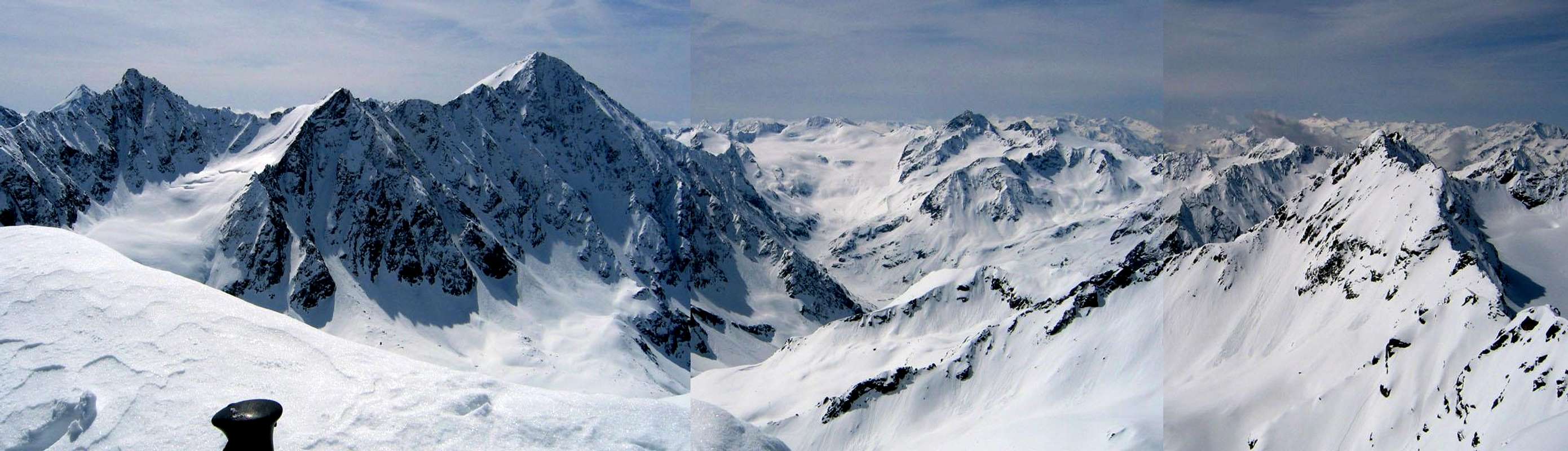
 Bachfallenkopf and beyond (by mvs) Bachfallenkopf and beyond (by mvs) |
To the west of the Stubai Alps there are a number of small subranges, which are divided by short, but profound valleys. Between Sulztal in the south ans Stuibental in the north there are two of these ranges: Larstiger Berge and Bachfallenstock. Access to the mountains is short but still the ranges are rather solitary. Hiking paths lead only to a few of the summits while the rest is only available for climbers and mountaineers. Especially the east of the range is only very rarely visited. The mountains of the range are made up from eruptive rock, mostly granite and gneiss. The latter tends to be brittle and shist-like explaining some of the lack of popularity of the two subranges.
The northern of the two ranges, Larstiger Berge, is grouped around its highest mountain, Strahlkogel (3295m) in its centre. Three long ridges run to the north while one short ridge heads for the south. The easternmost of the northern ridges, Larstigkamm, is the alpinistically most important part of the group. It is a long ridge consisting of numerous (8) summits, many of which can be climbed. The ridge is rather solitary but offers some interesting traverses. The centre of Larstiger Berge is glaciated though the glaciers are vanishing fast. For hikers the most important summit is Breiter Grieskogel, a close southern neighbor of Strahlkogel.
A bit to the south-east of Larstiger Berge you can find the even smaller Bachfallenstock, a rather compact small range. The mountains are arranged in a three quarter circle around Bachfalle, an impressive cirque in the centre. All summits show the remnants of glaciers, which were much more extensive only a few decades ago. The most important mountain is Hoher Seblaskogel (3235m), also the highest mountain of the little range. In the centre of the cirque you will find Winnebachseehütte, a perfect base for exploring the range which also is the reason, why Bachfallenstock is more popular than the northern Larstiger Berge. In winter it serves as a tour ski base for all the mountains of the vicinity.
2 - Larstiger Berge - Bachfallenstock on SP
3 - The Summits
  |
- Brand (2283m)
- Hemerkogel (2760m)
- Hörndle (2986m)
- Breiter Grießkogel (3287m)
![]()
- Gänsekragen (2915m)
- Nederkogel (2756m)
- Kreuzjöchle (2640m)
- Grasstaller Grießkogel (3160m)
- Strahlkogel (3295m)
- Sömenspitze (2682m)
- Larstiggrat (2898m, 3044m, 3052m, 3087m, 3063m)
- Larstigspitze (3173m)
- Larstigfernerkopf (3216m)
Bachfallenstock
- Westlicher Seeblaskogel (3046m)
![]()
- Hoher Seeblaskogel (3235m)
![]()
- Fuchsgrat (2728m)
- Grüne Tatzen (2952m)
- Bachfallenkopf (3176m)
![]()
- Längentaler Weißer Kogel (3218m)
- Gaißlehnkögel (3213m, 3216m, 3145m)
- Kühlehnkarschneide (3196m, 3188m)
- Putzenkarschneide (3120m, 3073m)
- Hohe Winnebachspitze (3155m)
- Niedere Winnebachspitzen (3054m, 2992m)
- Rötkögel (2708m)
Larstiger Berge


4 - Getting There
 Bachfallenferner (by reinhard2)
Larstiger Berge as well as Bachfallenstock are located to the west of the Stubai Alps. You can reach the subranges from Ötztal Valley.
- From Innsbruck follow motorway A12 to the west
- Leave at the Ötztal exit and take B186 to Umhausen or Längenfeld depending on wether you want to access the northern or southern part of the ranges.
5 - Accommodation
 Hoher Seeblaskogel and Westlicher Seeblaskogel (by reinhard2)
As for mountain huts, you can find the complete list on the Stubai Alps main page
6 - Red Tape
The east of the two small ranges is part of “Ruhegebiet Stubaier Alpen”, a nature preserve, in which any type of construction is not permitted. In any case trails should not be left and the usual restrictions apply.7 - Weather Conditions
8 - Maps & Books
9.1 - Maps
Kompass has some very good overview maps, scaled 1:50000 which show all the necessary trails but don't go into too much detail:
- Stubaier Alpen
Kompass Map WK83
1:50000
ISBN: 3-85491-092-4
Better are the maps by the German Alpine Club, available for the nothern (Austrian) part of the Stubai Alps. They are scaled 1:25000 and can be obtained by The DAV-Shop (look under "Zentralalpen"). Both hiking and ski-touring trails are marked on these maps.
- 31/1 Stubaier Alpen, Hochstubai
- 31/2 Stubaier Alpen, Sellrain
9.2 - Maps Online
9.3 - Books
- Stubaier Alpen
W. Klier
Alpenvereinsführer
Rother Verlag
ISBN: 3-7633-1271-4
- Ötztal
H. & W. Klier
Rother Verlag
ISBN: 3-7633-4094-7