
-
 4073 Hits
-
 71.06% Score
-
 1 Votes
|
|
Route |
|---|---|
|
|
46.58510°N / 11.97110°E |
|
|
Hiking, Mountaineering, Via Ferrata |
|
|
Summer, Fall |
|
|
A long day |
|
|
Steep biking, then hiking and at last medium difficult ferratta. |
|
|
Approach
You start the tour at Rif. Pederu, 1548 m. See the parent page of Lavarella, how to get there!
Route Description
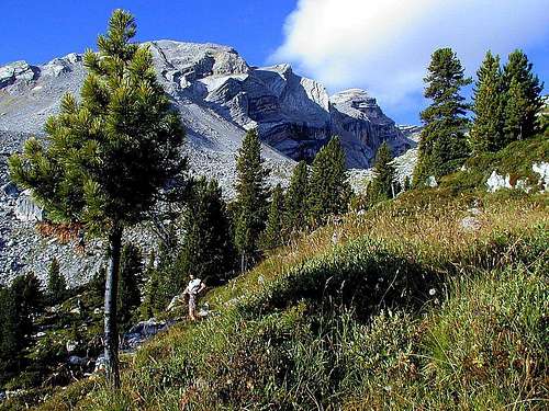


From Rif. Pederu you follow a steep macadam road towards the south. You can ride a bike up (mostly), if you don't have a very heavy rucksack. (We were carrying a tent, sleeping bags and the "kitchen" for two days, so at the beginning we had to walk.) After reaching Vallone di Rudo (1800 m) the street goes horizontally a good kilometer. Then it gains another 200 meters of altitude and you reach the lakes near both mountain huts (La Varella and Fanes). Till there, you will need one hour and a half. If you leave your bikes in bushes, you can proceed a few minutes and find excellent places to set up a tent (take care, it's a natural park!).
Marked path No. 12 leads us from the hut further towards the west. We are hiking up through a shallow valley, leave behind the last trees and reach the upper plateau on the altitude of 2350 m (Klein Fanes). Now the path is turning left-right-left-right through the karst-like landscape untill we reach a crossroads, where we turn left (south-west, not towards Kreuzkofel).
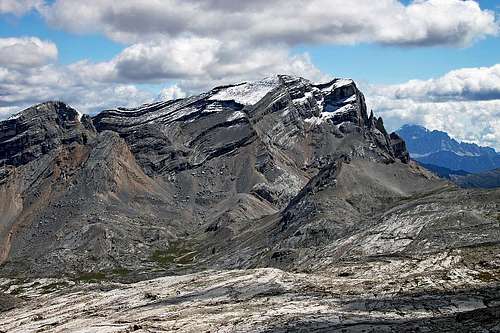
The path begins to climb again, and over screes we reach Forcella Medesc, 2533 m. The view towards the west opens freely. Now the path becomes a bit more demanding. First it goes steeply over screes, then it reaches the northern rocky slopes of La Varella and where they become vertical, the path uses ledges. It is all the time marked and well protected by pegs and steel ropes. Finally it goes straight up, reaches the notch between the main peak and west peak and over the summit ridge we finally reach the top. 3 hours from Klein Fanes Huts.
It is recommended to descend on the other side, and so make a round tour. The marked path leads us over screes towards the south, it keeps close to the main crest and soon reaches a small lake. From here to Piz dles Cunturines it's less than half an hour and it's certainly worth going up to the highest peak of La Varella group (medium hard ferratta, on one place a ladder over a vertical wall).
From below Piz dles Cunturines we return back and turn towards the east. The scree is not the best one for running down, but still it goes fast. We reach Lake Cunturines, proceed north of it and 400 meters lower finally reach the beautiful Gross Fanes (alpine meadow). Now we walk by the road towards the north, go over Passo di Limo (2174 m) and descend on the other side to our bikes. The fun begins!
Leaving behind numerous mountaineers we ride down to Rif. Pederu, and only there our hands can afford to relax from pressing brakes.
Essential Gear
A good mountain bike, walking sticks, good shoes.
Miscellaneous Info
If you have information about this route that doesn't pertain to any of the other sections, please add it here.