
-
 5706 Hits
-
 79.04% Score
-
 10 Votes
|
|
Route |
|---|---|
|
|
47.08128°N / 12.15894°E |
|
|
Hiking |
|
|
Fall |
|
|
A few days |
|
|
Easy, but enduring hiking (T2) |
|
|
Overview
Originally this is a multiday trek from Krimml on the north to Kasern (or Prettau) on the south. But it can have many variants, so I will describe here one of them, including also the visit of Wildgerlostal.
Since middle ages, if not since the times of antiquity, over the 2633 m high saddle of Krimmler Tauern there was a trade connection. On foot and with help of mules and horses, people were carrying goods, available on the south (in Venice) across the Alps, and goods, available on the north (Salzburg) in the opposite direction. It was a relatively short connection, requiring to cross the Alps only over one high pass. And yet today over the Krimmler Tauern pass no road goes. Everything is abandoned, smugglers are gone as well (no need for that in EU) and old stories forgotten. But visiting those mountains is highly rewarding, especially if you add to the trek one or two panoramic summits. That's why the Krimmler Tauern Trek is highly advertised to tourists and the mountain huts along it make quite some money. What is attractive is also that you can adjust length of the trek to your needs, time and hiking fitness. And the nature is very beautiful in that part of Alps.
Original Krimmler Tauern Trek
Krimml - Krimmler Tauernhaus - Windbach valley - Krimmler Tauern (saddle) - Prettau - Birnluecke (saddle) - Krimmler Tauernhaus - Krimml. (3-4 days)
Proposed Variant
Day 1 Krimml, 1067 m - Breitscharte, 1925 m - Leitenkammersteig and descent into Wildgerlostal at Trisslalm, 1584 m - Zittauer Huette, 2328 m.
Day 2 Zittauer Huette, 2328 m - (Rosskopf, 2845 m) Rosskarscharte, 2689 m - Keesboden in Rainbachtal, 2185 m - Richterhuette, 2374 m - Windbachscharte, 2697 m - (Eissee, 2569 m) Krimmler Tauern, 2633 m.
Day 3 Krimmler Tauern, 2633 m - Windbachalm, 1882 m - Krimmler Tauernhaus, 1631 m - Krimmler Waterfalls, 1482 m - Krimml, 1067 m. (Or extended version: Krimmler Tauern, 2633 m - Birnluecke, 2665 m - Krimmler Tauernhaus, 1631 m - Krimmler Waterfalls, 1482 m - Krimml, 1067 m.)
(Or you could descend on the Italian side to Pretau and on the day 4 return over Birnluecke to Krimml.)
Highlights
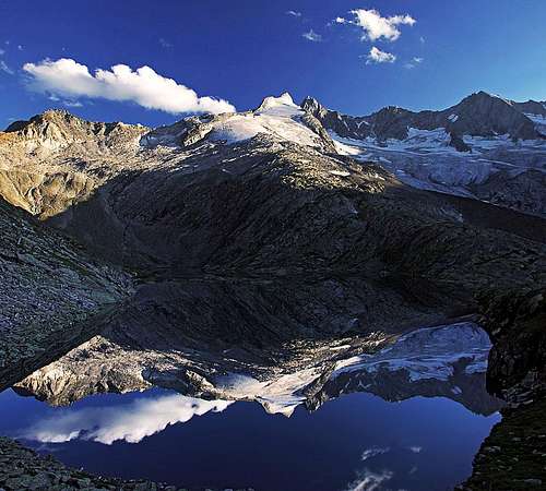 A perfect mirror
- Leitenkammersteig. A beautiful hike through a 'parkland' above Wildgerlostal - views, ponds, swiss pine trees, pastures.
- Wildgerlostal valley end. A fantastic view on Reichenspitze and Gabler.
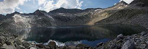
- Unterer Wildgerlossee. With Reichenspitze group reflecting in it.
- Rosskopf. An easy hiking summit with a nice panorama.
- Richterhuette. Old-fashioned hut for climbers and the wild mountains above it.
- Windbachscharte. Crossing a notch, which opens new views.
- Eissee. Crossing long, solitary slopes above the Windbach valley, and the high, dark lake.
- Unterer Kessel. Idyllic pasture with lovely water sources.
- Krimmler Tauern. A legendary pass over the Alps.
- Windbachtal. Long, picturesque valley with a crystal clear creek.
- Tauern Achental. Long, high valley with the Dreiherrenspitze and Krimmler Kees at its end.
- Krimmler Tauernhaus. A legendary mountain hut, dating back to 1389.
- Krimmler waterfalls. Claimed to be the biggest in Europe, a major tourist atrtraction of Austria.
General Information
|
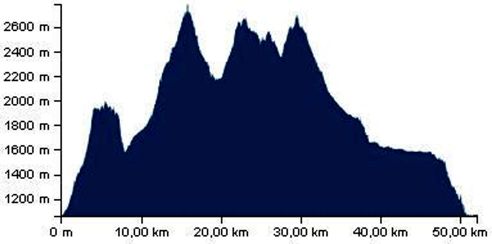
Technical difficulty: Technically the proposed variant goes by easy, marked paths only. On the Swiss Hiking Scale the difficulty would be graded T2. Only a short section over the Windbachscharte is protected by cables, but also there the difficulty hardly rises to T3. Endurance: If done by the proposed agenda, the first two days require good fitness. It depends also how much you carry with you. We had a tent, sleeping bags, food and drink for 3 days, so in the beginning backpacks were very heavy. At the end of day 1, you could sleep in Zittauer Huette, at the end of day 2, on the other side of Krimmler Tauern there is only a small hut. Altogether we did in 3 days some 3500 m of ascents and descents and the whole distance was close to 55 km. Day 1 was the most enduring, with 1850 m of altitude gained and 450 lost. In day 2 we covered more distance, gained 1400 m of altitude and lost 1250 m. Day 3 was mostly a long descent, with 250 m gained and 1800 m lost. If we had less troubles with shoes and ankles, the trek would also be easier.
|
Orientation: All paths are well marked and signposted. We had a hiking map (Kompass: Venedigergruppe, Oberpinzgau, 1:50.000), but more for general orientation and to read toponymes. Still, in some sections (between Windbachscharte and Eissee) the path goes across broad slopes of a rocky desert, where you must be all the time attentive not to lose marks. In poor visibility there you can face orientation issues and advance much slower.
Exposition: Almost no vertigous sections. Over Windbachscharte there's a few meters long, protected ledge, with some air below.
Objective dangers: In summer, there's almost none. Poor visibility and storms could make troubles on those high altitudes. In summer have something to protect against direct sun rays. All along the route there's plenty of water, so you don't need to carry much of it.
Best season: Summer and autumn, when the huts are opened. Long daylight is very beneficial.
Gear: Good shoes and poles. To be independent, eventually a bivouac equipment (we enjoyed sleeping in a tent). Good food can be bought also in huts, but beer is around 3.5 EUR.
Tour start: Krimml can be reached by a good road from Mittersill (there you can come from all sides), or across Gerlos pass from Mayrhofen. You best leave your car on the public parking lot near the tourist office (in 2015 2 EUR/day). Don't park on the parking lots for watefall visitors.
Highest point: Rosskopf, 2845 m (if you summit those additional 145 m). So, in summer there's no glaciers or snowfields crossing. Useful mountain huts:
- Zittauer Huette, 2328 m.
- Richterhuette, 2374 m.
- Krimmler Tauernhaus, 1631 m.
- Neugersdorfer Huette / Rif. Vetta d'Italia, 2568 m. On the Italian side of Krimmler Tauern (status unclear).
Route Description
Day 1
From Krimml you aim first the Schoenmoosalm, a hut on the road to Gerlos pass. Till there you could take also a post bus, but it leaves early and there's no point waisting time and money for those 370 m of altitude. You go W by the road to Burgeck hotel and then by the marked path (mountain bike piste) further to Schoenmoosalm, 1434 m. There cross the road and continue ascending in the same direction (path No. 49). The path ascends over alpine meadows, light woods, on 1700 m you cross the Schoenmoos Hochalm and then ascend more steeply on the main ridge - Breitscharte, 1925 m. There, you'll meet meople again. They come down from the nearby Plattenkogel, reachable from Gerlos pass by cable car.
 Above Krimml Above Krimml |
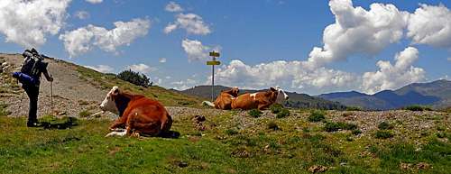 Now who is on vacations here? Now who is on vacations here? |
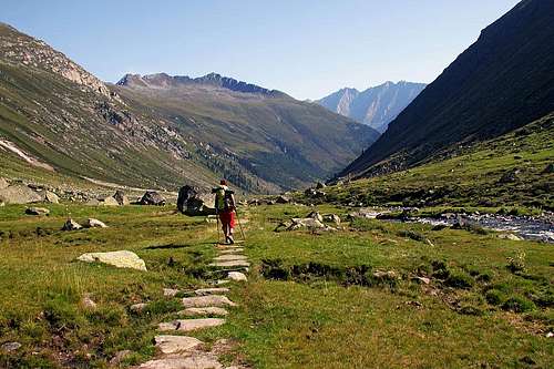
On Breitscharte a more beautiful part of the trek starts. First a mountain road, then a broad path goes almost horizontally across the slopes above Wildgerlostal. From many points you have nice views down on the lake and across it on the Gerlos region. But the best is yet to come. Before reaching the Wildkar Hochalm, 1062 m, the path goes through an exceptionally nice landscape. There are some wetlands with small ponds, strong, dark green swiss pine trees and ahead of you already the Reichenspitze and Gabler are shining above their glaciers. Then you reach the pasture, where the Leitenkammersteig keeps right and soon starts descending. By the meadows and through the woods you lose almost 400 meters of altitude and get on the valley road at Trisslalm hut, 1584 m.
 Leitenkammersteig Leitenkammersteig |
 Leitenkammersteig Leitenkammersteig |
 Wildkar Hochalm Wildkar Hochalm |
 Wildgerlostal Wildgerlostal |
 Refreshment Refreshment |
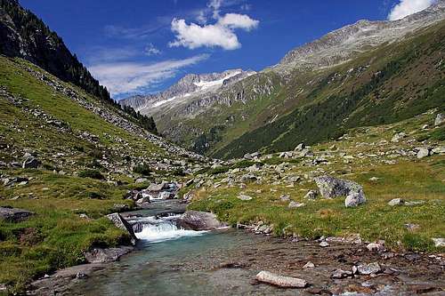
Up the Wildgerlostal you go all the time by the road, only immediately after Trisslalm you can take a shortcut. On the right a vivid creek accompanies you and the more you approach valley end the more beautiful are views on Reichenspitze and Gabler. By the lower station of material cable car (Im Grund, 1888 m) you take the marked path to the hut. The plate says you have till Zittauer Huette 1 h of walk, but it's still 450 m of elevation gain, so adjust expectations. |
 By the waterfall By the waterfall |
The marked path continues in many comfortable switchbacks southwards. When it approaches the steep rocky step with a waterfall, it gets protected by cables. Over there the path is very steep, but still broad and without any difficulties. Above the step the path gains a distinct ridge, from which you have a nice view on the Reichenspitze glacier (Wildgerloskees). An explanation table teaches you about its size changes. Then you continue the ascent southwards, but soon the path turns eastwards, towards the hut. By interesting plates it crosses the creek and then ascends over the last bumps towards the big hut, 2328 m. With the big lake and views on Reichenspitze it is a wonderful place to rest. If you won't sleep in the house, our proposal is to continue eastwards and then by the slopes around the lake and southwards up, on the edge 2469 m, on the terrace above the lake, where paths are branching. There's water, your tent will not be seen from the hut and yet the place is very panoramic. |
 Before Zittauer Huette Before Zittauer Huette |
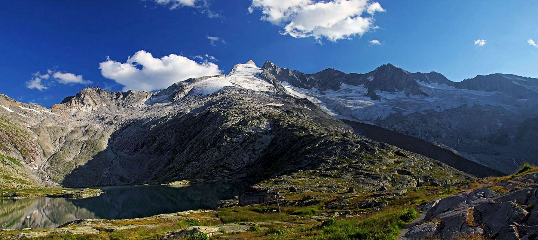 Reichenspitze from Zittauer Huette Reichenspitze from Zittauer Huette |
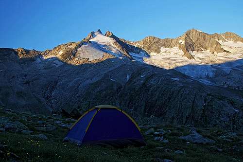 Bivouac place 1 Bivouac place 1 |
Day 2
 Towards Rosskarscharte Towards Rosskarscharte |
Next morning we continue from the crossroads 2469 m southwards. Across the broad, only slighty slanted plateau, the path slowly gains altitude. We ascend over a few rocky steps, aiming all the time right of the summit of Rosskopf. Just before the path reaches the Rosskarscharte, on ca 2700 m the summit ascent route branches left. It is certainly recommended to ascend also Rosskopf. This easy summit is very panoramic and will represent the highest point of our whole trek. So, leave all your heavy lugage on the crossroads 2700 m and follow the path, which in switchbacks soon gains the main ridge, goes by big rock blocks and in next 20 minutes we are on the Rosskopf. |
 Unterer Gerlossee Unterer Gerlossee |
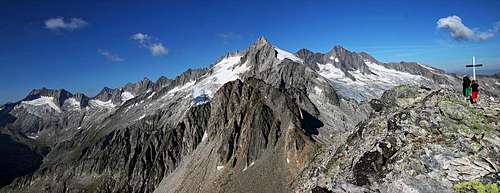 Reichenspitze group from Rosskopf Reichenspitze group from Rosskopf |
 Rosskopf southeast views Rosskopf southeast views |
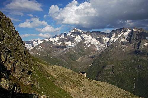
From the summit you descend to your luggage and continue those few more minutes on the Rosskarscharte, 2689 m. The descent from it towards the SE is first a bit steep and crumbly, then a comfortable path keeps left, almost on the same altitude, crossing the southern slopes of Rosskopf. The direction is SE and only towards the end of the high Rosskar terrace, the path turns down in the S direction. In a few turns it loses altitude, passes a water source and then continues across the Rosskar valley, until reaching a small pond, named Rosskarlacke, 2293 m. There the path starts crossing the steep slopes of a distinct ridge, descending from the summit of Mannlkarkopf. When coming around the edge, a great view cross the Rainbach valley opens. On the other side are the glaciers below the Rainbachspitze and above the valley end the Richterhuette. The path then crosses long slopes till the valley end (Keesboeden, 2185 m), where it crosses the creek and reaches the road end at the lower station of material cable car. The ascent to Richterhuette is a short one. A good path goes in switchbacks up, then much to the left and after gaining almost all altitude, only comfortably crosses to the hut, 2374 m. Nice and wild mountain scenery there.
 Reinbachspitze Reinbachspitze |
 Reaching Richter huette Reaching Richter huette |
 At Richter huette At Richter huette |
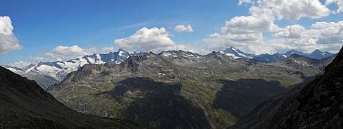 The broad panorama from Windbachscharte The broad panorama from Windbachscharte |
From Richterhuette you follow signposts to the Windbachscharte. The path goes by a broad ridge towards the SE, passes a small lake, then soon starts turning left, where over a more steep terrain it gains altitude. Only when reaching some 2600 m, the path starts crossing the W slopes of Windbachtalkogel. In the beginning of the crossing, a marked path deters left on its summit (2843 m), later, towards the end of the crossing, another weak marked path deters right, towards the summit of Warze, 2802 m. If we are not keen for summiting, we just continue gently up, and only below the notch, the path ascends very steeply. There some care is needed, but the terrain is not too exposed. |
 Windbach walley Windbach walley |
From the Windbachscharte, 2697 m, the path descends left by a narrow, a bit airy ledge. There it is protected by steel cables, but this a bit more demanding section is short. Then we descend on a less steep rocky slope, where the path turns sharply right again (towards the SW). The long crossing of slopes above Windbachtal is ahead of us. The good news is, that the path soon starts ascending again. This way it shows it will not be losing altitude, but will try to hold it all the way till Eissee. Till there, it's still a lot of distance. The path goes all the time towards the south, a bit up and down, where terrain allows, it is carefully built of granite plates. It also crosses many water streams and is all the time panoramic. Below the Keeskar we approach the ridge of Archbuehelkopf, which the path must detour. There is a huge chaos of granite boulders and the path must lose some altitude to find the best way through it. On the other side it ascends again and finally we reach the slopes below Eissee. |
 Eissee Eissee |
A plate tells us, it is 100 more meter up to the right to reach the lake, 2569 m. We must be tired, but visiting the peaceful, dark lake is very recommendable. After enjoying a few peaceful moments on its shore, we return down to our backpacks and continue crossing the slopes southwards. A few minutes later we reach another crossroads. There a direct path descends left into the Windbachtal. But taking it would mean to break the trek, not reaching the historical Krimmler Tauern. So we continue by the so called Kesselweg. |
 Unterer Kessel Unterer Kessel |
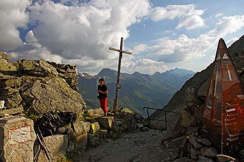
Unfortunately, even if we have already almost all the altitude, the slopes to Krimmler Tauern can not be only crossed. Before us is the deep Unterer Kessel (cauldron) and the marked path descends just to its bottom. So we descend from some 2450 m to good 2300 m. There's an exceptionally nice pasture, with beautiful water sources, but we shall probably only continue to do the last ascent. A wonderfully built path soon brings us up over the slopes and in less than 1 h reaches a small plateau just below the saddle, where it joins the main historical path. There's a small hut (closed), but we shall first go up on the notch, 2633 m, to reach the ultimate goal of our trek. The view from Krimmler Tauern on the Italian side is great, especially on Dreiherrnspitze. On the other side of the saddle is a few minutes away also a small hut, which in 2015 looked to be open. But we can also return on the Austrian side and find a flat place to set up a tent. |
 Bivouac 2 Bivouac 2 |
 The famous, historical Krimmler Tauern pass The famous, historical Krimmler Tauern pass |
 Dreiherrenspitze from Krimmler Tauern Dreiherrenspitze from Krimmler Tauern |
Day 3
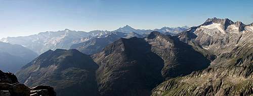
 Morning on Schientalkopf Morning on Schientalkopf |
The third morning we may perhaps ascend the nearby summit of Schientalkopf, 2774 m (on the map also Schuettalkopf). From the notch it's only good 150 m of ascent, the path is marked and easy, the views around very rewarding. Then we take our luggage and start a long descent to Krimml. |
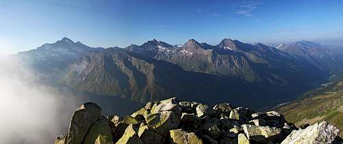 Schientalkopf panorama Schientalkopf panorama |
 Descending by the upper Windbach valley Descending by the upper Windbach valley |
 Windbach valley - the lower part Windbach valley - the lower part |
 Krimmler Achental Krimmler Achental |
From Krimmler Tauern we all the time follow the old, well beaten trade path down to Windbachtal. It goes first northwards, then descends westwards, where below the Unterer Kessel it crosses the creek, then it goes all the time towards the N and NE by the left side of the valley. The landscape slowly changes, the long valley is very beautiful. On 1882 m we reach the Windbachalm, where we hit the mountain road. But soon below the alpine pasture the marked path leaves the road again and follows the vivid creek. Over the valley step the shortcut descends in many switchbacks and we are down in the broad, long Krimmler Achental. On the right, the glaciers below Dreiherrnspitze are shining. Now we only continue northwards and soon reach the historical Krimmler Tauernhouse, 1631 m. |
 Dreiherrnspitze Dreiherrnspitze |
 Krimmler Tauernhaus Krimmler Tauernhaus |
There's still some distance to Krimml. If we don't opt for a hut taxi (that's not a trekking), then we continue hiking down the flat valley. The most beautiful part of it is the strong Krimmler Ache, the creek, which is already more a river. The road goes by its right side, passes some nice alpine meadows with huts and finally reaches the part, where the valley gets narrow. But the creek does not fall down over the valley step immediately. We still need to walk some 20 min to reach the upper waterfall. There the tourist path leaves the road, crosses the creek and goes down by the left side of waterfalls. |
 Krimmler Achental Krimmler Achental |
The views on them from many observation points are exceptional! There are three big falls, the total elevation difference is more than 400 meters. Finally from the lower exit of the tourist path we walk into the town of Krimml. The big trek is accomplished.
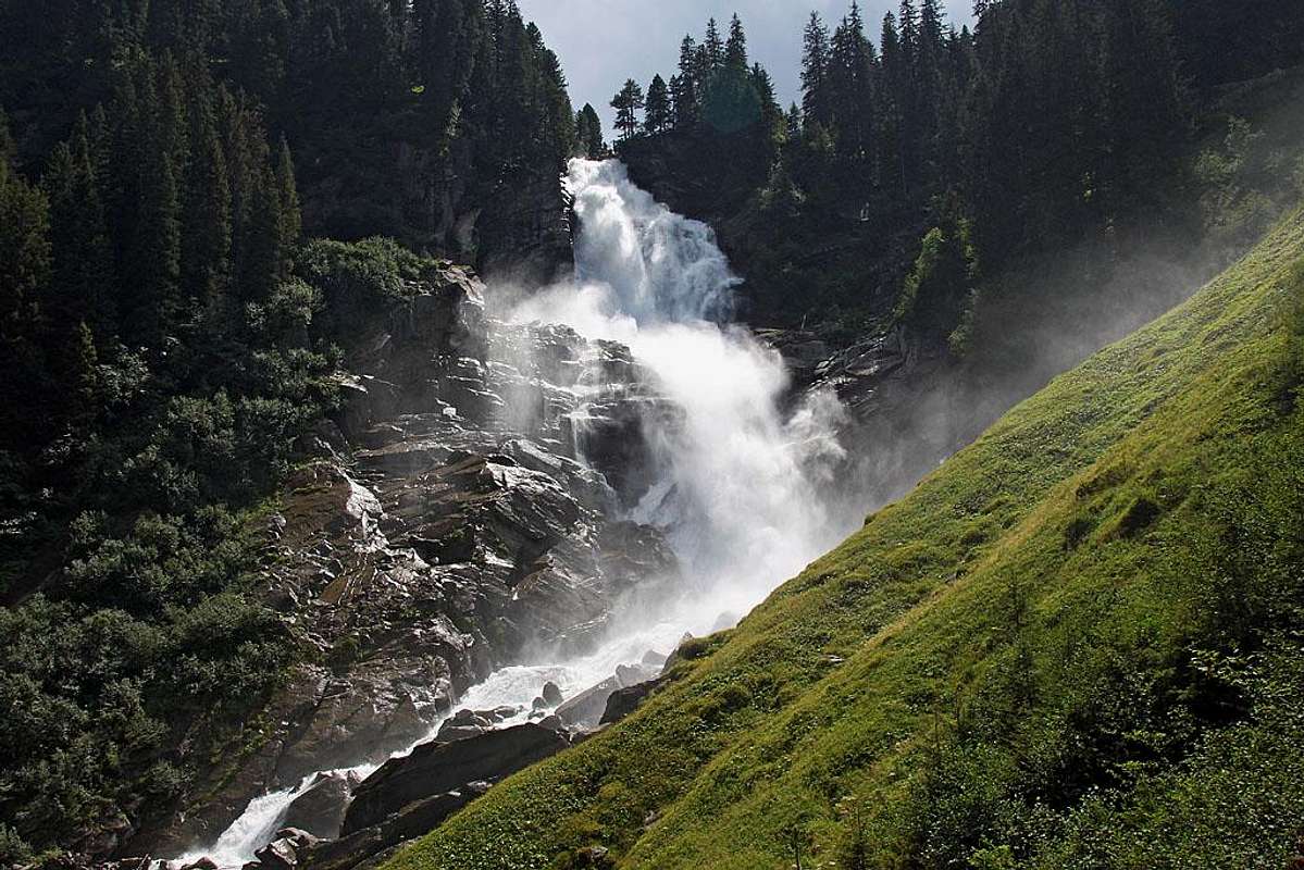 Krimmler waterfalls Krimmler waterfalls |
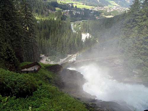 Krimmler waterfalls - accomplishing the long trek Krimmler waterfalls - accomplishing the long trek |