
-
 5244 Hits
-
 72.08% Score
-
 2 Votes
|
|
Route |
|---|---|
|
|
46.43510°N / 13.68810°E |
|
|
Mountaineering, Scrambling |
|
|
Summer, Fall |
|
|
Most of a day |
|
|
Class 4 |
|
|
UIAA I-II |
|
|
Introduction
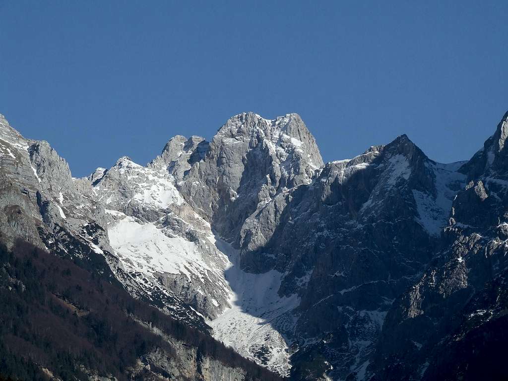
The western route on Kotova špica is using the easiest, natural passages through a rugged western face of the mountain and the ravine, falling down from the notch between Kotova špica and V Koncu špica. Once this route was marked and protected (as part of Italian border defence system), but today it is much destroyed. The ascent still represents a nice, memorable venture into quite unknown territory of Julian Alps.
General Information
Difficulty: It's a hiking tour, with many places of easy, also exposed climbing of UIAA I and II degree. The rock is very brittle. Some such places are still protected by steel cables and pegs, but all the devices are decayed and not reliable. On the Swiss Hiking Scale the difficulty of route can be graded T6/T5.
Orientation: Through Koritnica valley the route is well marked, but from the point 1900 m on - till the summit - marks are much decayed and we must be very careful to follow them and choose the best passages. Maps to be recommended: Tabacco No. 19. 1:25000. Planinska zveza Slovenije: Mangart - Jalovec. 1:25.000.
Slopes orientation: Koritnica valley is south oriented, but the steepest slopes till the main ridge are west oriented. The summit ridge is the north oriented.
Exposition: Some places are very exposed and so not appropriate for people suffering from vertigo.
Objective dangers: In the west ravine there is a big danger of falling rocks. On the summit ridge there is a danger of storm and lightning!
Best season: Summer months, normally from July till October (or first snow). In autumn be careful due to shorter days (long approaches)!
Gear: Good shoes, helmet and poles are sufficient. For less experienced a short rope (20 m) might be useful.
Tour start: The end of the road into Koritnica valley, 850 m. You deter into the valley just above the village of Log pod Mangartom. Alternatively, you can start this ascent also in Planica valley (Tamar), 1108 m. But then you must go over Kotovo sedlo (pass), where you lose more than 300 m of gained altitude (and must do it again on return). That's a very long tour!
Highest point: 2376 m.
Altitude to overcome: cca 1525 m, 4 h 30 min.
Route Description
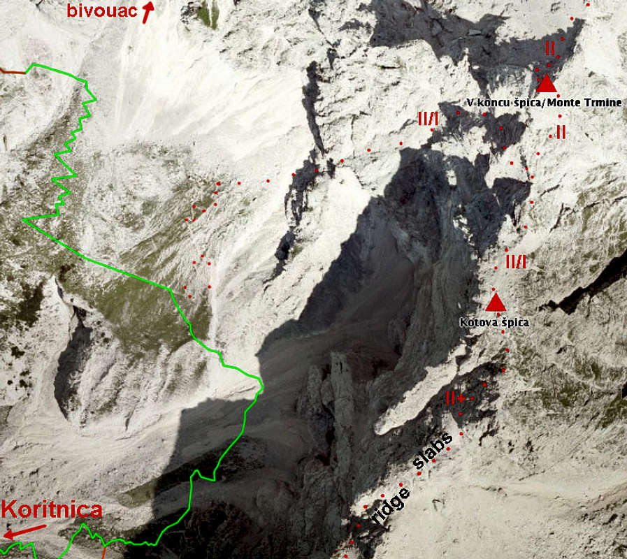
1. Parking place, 850 m - below Hudi žleb, 1350 m. 1 h 15 min, T1.
From the parking place you simply continue into the valley, ascending gently. Soon the marked path on Čez Brežice deters right, there you continue ascending towards the NE. So you reach a more flat part of the valley (Lanžev plaz), just below the distinct ravine of Hudi žleb (this one is going northwards).
2. Below Hudi žleb, 1350 m - path branching, 1700 m. 1 h, T2.
On the upper part of the plane you have two choices: the unmarked hunters path and the marked path. The latter continues right by the valley. Soon it ascends the scree slopes, falling from below the W walls of Kotova špica. On some 1700 m from the right the marked path from Kotovo sedlo joins (in descent).
3. Path branching, 1700 m - path branching, 1900 m. 30 min, T3.
We continue towards the valley end (northwards), ascending quite steep and tedious scree fields. Higher, below Kotova špica walls, the path keeps left and soon from the left the already mentioned hunters path joins. It is not marked and continues up, towards Rob nad Zagačami / Forcella Zagherza (notch).
Alternative - hunters path (1350 m - 1900 m). 1 h 30 min, T3.
Soon after the flat valley part below Hudi žleb ravine from the marked path a well beaten hunters path deters towards the north. It is not marked, but goes more comfortably in many switchbacks below the walls of Mangart towards the north-east. On 1900 m it joins the marked path.
4. Summit ascent. 1 h 30 min, T6/T5.
On the upper part of screes the marked path turns left (towards the bivouac), but we turn on an easy shelf towards the right. Behind the edge we turn up and ascend by the left side of a ravine. Somewhere in the middle we notice steel ropes which lead us towards the right (a long and very exposed crossing) - just to the wall. Ropes are very unsafe, just every peg is unstable! Above all, the ledge is narrow, covered with round stones and the rock is bad. On the other side we continue upwards and then diagonally towards the left on the notch (also by a help of steel ropes). It all shows how this secured route was destroyed by avalanches. From the notch to the summit it's easier. The route mainly follows the ridge there's only one harder vertical step which we avoid by a narrow ledge towards the right (very exposed - called "pavement").