

-
 3078 Hits
-
 80.49% Score
-
 12 Votes
|
|
Route |
|---|---|
|
|
Trad Climbing |
|
|
Spring, Summer, Fall |
|
|
Half a day |
|
|
5.10a (YDS) |
|
|
3 |
|
|
Overview
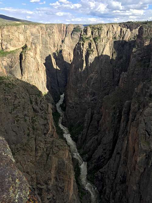
North Rim of the Black Canyon
King Me 5.10-
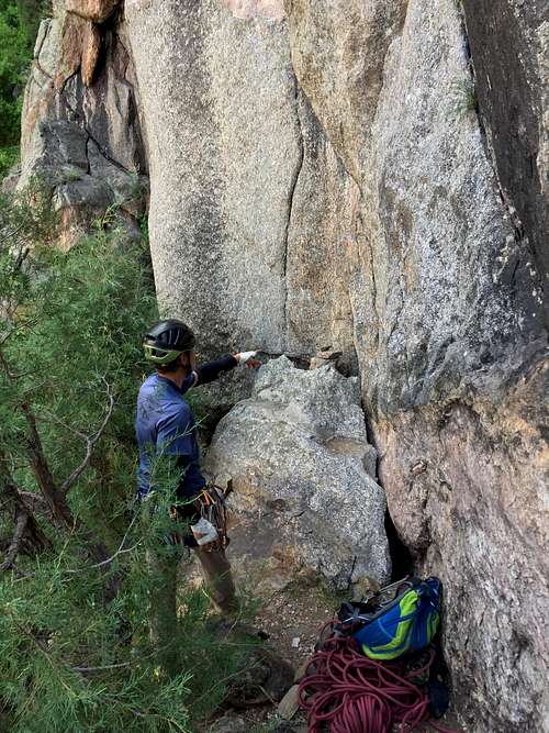
All climbs are within the designated Wilderness Area of the Park's Inner-Canyon and you will need to obtain a free backcountry permit at the North Rim Ranger Station. There is a self-registration note at the entry into the canyon, including a board with names of climbers and route climbing. An extensive "climbers notebook" is kept at both the North Rim Ranger Station for reference. You can copy the descriptions and topos.
First Ascent: Josh Gross, Madoline Wallace in September 2007
First Ascent: Josh Gross, Madoline Wallace in September 2007
Pitches: 3
Guidebook: new guidebook by Vic Zeilman "The Black: A comprehensive climbing guide" provides a detailed description including a topo. The old guide book by Robbie Williams does not mention the climb.
Sun: afternoon (Black canyon can get very hot, start early in the summer a climb in shade, carry plenty of water with you).
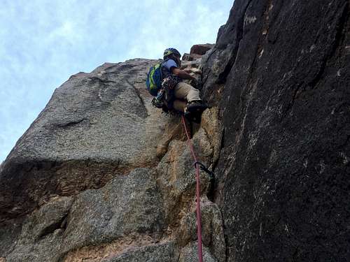
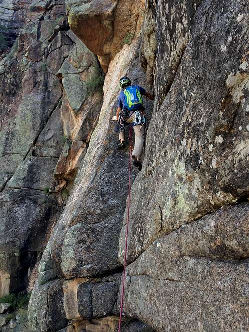
![King Me - start]()
King Me - start![King Me]()
King Me
King Me is located on the North Rim of the Canyon. Most climbers climb first Maiden Voyage (or other climbs on Checkerboard Wall) and approach King Me from the walk off trail.
To reach the North Rim: Take Hwy 92 past the town of Crawford and turn right (west) onto the North Rim Road, follow the signs for the national park for 11 miles to the North Rim Ranger Station and the North Rim Drive. The first half of the road is paved; the second half is graveled, but suitable for all vehicles. The road and the North Rim Ranger station are closed in the winter.
Note there is no road that links the rims within the National Park - you have to drive around. It is more than 70 miles.
To reach base of the Maiden Voyage climb, you need to descent via Cruise Gully. The best place to park is either Ranger Station, or the entry to the campground. From the campground (little less walk), walk towards the ranger station. Look for a well established path on your right that leads into the trees, located about 50 yards past the SOB trailhead and 100 yards up from the ranger station. Once you enter the path, there will be a sign Cruise Gully and a remainder that you need a free back country permit to descend into the canyon.
The descent is class 3-4 scramble, with 2 rappels near the end. Both rappels had fixed static lines. There is poison ivy between rappels 1-2 and below the rappels (no poison ivy above the rappels).
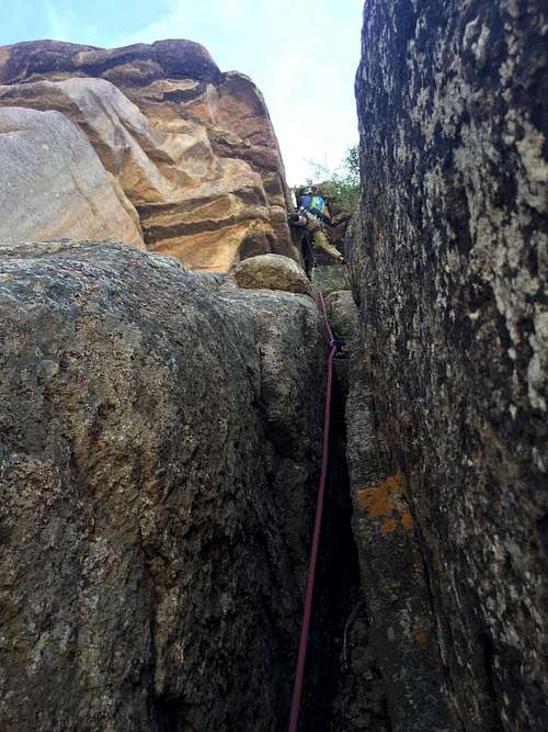
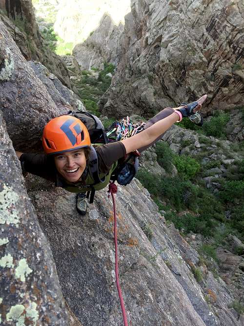
![King Me - 2nd pitch]()
King Me - 2nd pitch![King Me]()
King Me
Approach: King me starts of the walk off trail, about 100-120 meters from the Maiden Voyage. The start is marked with a small cairn and is located between two trees where the trail makes a turn. Look for a section of steep gray rock, just to the right of some black prominent streaks.
Getting There
King Me - start
King Me
To reach the North Rim: Take Hwy 92 past the town of Crawford and turn right (west) onto the North Rim Road, follow the signs for the national park for 11 miles to the North Rim Ranger Station and the North Rim Drive. The first half of the road is paved; the second half is graveled, but suitable for all vehicles. The road and the North Rim Ranger station are closed in the winter.
Note there is no road that links the rims within the National Park - you have to drive around. It is more than 70 miles.
To reach base of the Maiden Voyage climb, you need to descent via Cruise Gully. The best place to park is either Ranger Station, or the entry to the campground. From the campground (little less walk), walk towards the ranger station. Look for a well established path on your right that leads into the trees, located about 50 yards past the SOB trailhead and 100 yards up from the ranger station. Once you enter the path, there will be a sign Cruise Gully and a remainder that you need a free back country permit to descend into the canyon.
The descent is class 3-4 scramble, with 2 rappels near the end. Both rappels had fixed static lines. There is poison ivy between rappels 1-2 and below the rappels (no poison ivy above the rappels).
Route Description
King Me - 2nd pitch
King Me
Pitch One: Face climb through some steep flakes and edges on gray rock. You will find some protection with small micro camps here. Climbing was rated as 5.10, but felt relatively easy. Higher up you will see an old piton (not seen from the start of the route), climb left up the wall and move into a crack. Climbing becomes much easier here. Get over a small ledge onto a bigger ledge right above it - this 2nd ledge is about 1.5-2 meters wide and about 6-7 meters long. Establish anchors here - plenty of cracks here, which take even bigger cams (we used 0.75, 1 and 2 camalots). 50 meters
Pitch 2: Traverse on this relatively large belay ledge left and move onto a large, right facing corner system. There is a wide crack there. This section is rated as 5.8/5.9. Continue up the obvious corner towards the huge orange looking roof, just before the rock starts to steepen into the roof, move left and traverse along a nice crack onto a ledge with roof (almost like a cave). Establish anchor here. 55 meters
Pitch 3: If you look through the chimney of your belay "cave", you will see the top of the rim and the overhang = your goal. This pitch is short ~ 25 meters and rated as 5.10-. Climb a long angle off width to a bulge. Get some gear below the roof and climb to the left of the bulge on the face. There is a tree right above this bulge where you can set up an anchor.
Exit: Walk off on a small trail along the canyon rim. The walk off was surprisingly short and easy. Head back towards the trail leading to Cruise Gully, if trying to make a short cut, you can end up with a lot of bushwhacking.
Essential Gear
- Personal climbing gear
- Startard rack - micro-cams useful on the first pitch, up to #4 camalot
- 60 meter rope