The majority of trekkers reach Uhuru peak by the Marangu route, also known as the “Coca-Cola” route. A much lower number of climbers follow the Machame route (aka the “Whiskey” route) but very few take the much more spectacular and steeper Umbwe route. It is very difficult to find a tour operator who will combine the latter route with access to the crater rim via the Western Breach because the entire trek from the valley is considered too tiresome for most tourists and for the porters who must carry food and camping equipment up the mountain.
I perused published reports and searched the World Wide Web to find tour organizers that would be willing to arrange such a combined tour for myself and my son Christoph. Our goal was to complete the ascent and descent in 5 days because we wanted to schedule our trip immediately after one week of mountaineering in the Swiss Alps. In that way, our acclimatization to high altitude was achieved prior to our arrival at Moshi, the gateway city to Kilimanjaro. Tour outfitters repeatedly advised us that such an undertaking in 5 days’ time was “simply impossible to do”; however, we found one sympathetic travel manager at www.wildfrontiers.com. I corresponded many times by email with this African-based outfitter to get an acceptable package which included all transportation arrangements in Tanzania. I want to emphasize that we avoided major expenses by arranging everything directly with an African outfitter and not using an American- or European-based travel agent. The World Wide Web was an ideal vehicle for comparisons of itinerary options and pricing of travel packages.
We spent relatively few hours at lower altitude levels and were able to maintain our bodily acclimatization to high altitude due to the fact that we took a direct non-stop flight from Amsterdam to Kilimanjaro Airport less than 24 hours after the last day of our mountaineering week in the Alps. In addition, the jet aircraft was pressured to 10,000 ft during the 12-hour flight which maintained our acclimatization. Moreover, we arrived in Tanzania at 21:00 (local time) and the guides met us at 8:00 the next morning at our hotel in Moshi. We began trekking at 11:30 at the Umbwe gate of Kilimanjaro National Park [alt.1600m]. Our group consisted of both of us, one guide, one assistant guide and 5 porters who carried our clothes, trekking gear, tents, water, food and other paraphernalia needed for camping enroute.
We hiked on the first day under a thick canopy of tropical vegetations. The trail was quite muddy because of frequent showers due to a perennial cloud cover around Kilimanjaro. On some steep spots we pulled ourselves up by using hanging branches or roots, but the porters had to do the same while carrying bags on their heads without losing balance or falling, an amazing feat since they wore sandals. We arrived 5 hours later with minimal fatigue at our first camp site: the Umbwe Caves [alt. 2850m]. At that location as well as in all other camping stops we were pampered by the guide and porters with warm food (dinner and next day breakfast) served in a private tent, as well as snacks and tea whenever we desired them. We did not encounter other trekkers at this or other higher camps during our climb which was fairly typical for the Umbwe route.
On day 2 we left camp at 9:30 and trekked on a ridge surrounded by fantastic moss-covered vegetation in the midst of thick clouds. The degree of steepness of the trail was similar to that encountered on our first day. After two hours of trekking we were able to glimpse, far above us through breaks in the cloud cover, the summit of Kibo with its dramatic, hanging glaciers. I had never imagined that Kilimanjaro was such a huge volcanic mountain. Those initial impressions of the mountain and the deep valleys below the ridges that we hiked on became unforgettable memories. Shortly thereafter, we were above 3200m of altitude, beyond the perennial cloud layer surrounding Kilimanjaro. We arrived at our second camp, Barranco Hut [alt. 3950m] about 5 hours (including leisurely stops) after our departure from Umbwe Caves. We had gone from a trail that meandered through lush vegetations to a dry moorland zone with sparse clusters of giant groundsels and, for the remainder of the ascent, we were above the fog and clouds. We were once again treated in a regal way, after setting camp, with food and other amenities.
On day 3 we left camp at 9:30. The slope of the hike was fairly moderate so that we barely felt the effects of the high altitude. The vegetation was barely existent since we were in a high Alpine desert zone. Four hours later we arrived at our highest camp site, near the abandoned Arrow Glacier Hut [alt. 4850m]. The hanging glaciers that we had first glimpsed on the previous day were much closer. We had an early dinner at 17:30 and thereafter tried to rest. The air temperature was quite cold after sunset at this altitude. It was difficult to fall asleep due to the anxiety in anticipation of the final scramble to the crater rim and due to the high altitude. The location of our camp was higher than any summit in the Alps and we had another 1000m of elevation ahead of us; however, we thought that were fairly well acclimatized and did not take any medications to prevent acute mountain sickness.
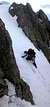
A few hours later we were awakened by the guides for tea and snacks prior to the Western Breach climb. The porters descended with all the camping gear and food to the lower Southern Circuit and met us again at the Horombo Hut on the next day. We began the uphill scramble with the guide and his assistant at midnight under a full moon. We did not use any ropes or belays for the climb because there were many good hand- and foot-holds. The effects of high altitude were very noticeable as we climbed. Christoph had strong headaches and almost had to abandon the effort due to fatigue. Even the assistant guide felt ill. Nevertheless, after several stops and by eating high-calorie concentrated snacks, we were able to continue and finally glimpse the first sun rays peeking above the crater rim.
It took us more than 5 hours to reach the inner cone of Kibo [alt.5700m] and another 90 minutes to reach the Uhuru peak [alt. 5895m]. At 7:00 we were on the top of the roof of Africa: a dramatic flat crater, a barren site surrounded by huge retreating glaciers. For the first time since we began our ascent, we encountered other trekkers at the summit and also during our descent. It was very windy and bitterly cold at the top but we had succeeded in reaching the summit of Kilimanjaro by a seldom used but much more spectacular route.
We descended from Uhuru peak by the most frequently used trail, the Marangu route. In this way we were able to experience the much longer but easier route on descent. Moreover, we also avoided descending on the Umbwe or Mweka routes which were shorter but where the risk of injury (from falls or slipping on the muddy trail at lower levels) was greater. The Marangu route was on steep loose gravel below Gillman Point and the surrounding landscape was barren and uninspiring. Indeed, the dramatic spectacular hanging glaciers that we had admired for 2 days were not visible from the route because the trail was located on the other side of the huge mountain. We continued to our next overnight camp site, the Horombo hut [alt.3720m] which we reached at 16:00 after a very long descent on a fairly flat trail in the moorland. We glimpsed the interior of the huts where sleeping bunks were provided for trekkers using the Marangu route and were surprised by the spartan accommodations. It was a dramatic contrast to the very pleasant camping that we had experienced.
On our 5th and last day of the trek, we left our campsite at 5:30 and hiked for about 5 hours through the cloud cover and into the lush vegetation forest prior to arriving at the Marangu gate, the starting point of this route and distant about 52km from the Uhuru peak. In conclusion, the combination Umbwe-Western Breach route offers to anybody who is physically fit the most rewarding and spectacular experience for trekking to the top of the roof of Africa.


Comments
Post a Comment