
Comments
No comments posted yet.
|
|
Trip Report |
|---|---|
|
|
42.21444°N / 80.17255°E |
|
|
Download GPX » View Route on Map |
|
|
Dec 8, 2012 |
|
|
Summer |
Kyrgyzstan is an amazing and little explored country that offers countless technical and high altitude experiences. The peaks are shear and varied in their structure and composition. Khan Tengri is unique, having a marble face above 6000m. There are many peaks from 5-6000m near the Basecamp to acclimatize on or just to climb. The weather can change quickly in this range as you have a near by large lake in one direction and the desert in the other with drastic change in altitude. Snow can be common in especially at higher camp keeping teams form either ascending or descending. This mountain takes both skill and desire, it is no walk up being the northern most 7000m peak.
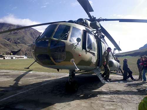
The Process of getting to where you want to go was often very involved. I flew from IAD Dulles to SVO Moscow to FRU Bishkek about 30 hours travel time. From Bishkek took transfer to Bokombaevo Village to stay at a guesthouse. Then transferred via six-wheel drive truck to Terskey Ala-Too area about 10-12 hours driving from Bishkek. After climbing there for a few weeks we transferred to Karakol (a slightly more Westernized town) a starting point for many climbers and stayed a night. From there we transferred to Maidadir air base run by Tien Shan Travel. About a four hour drive on a single track road and then took a flight to Khan Tengri BC 40min up the Northern Inylchek Glacier.
Base Camp to Camp 1: I was in the Kyrgyzstan Basecamp, it took about an hour to navigate the glacier to the base of the climb. From there had to ascend about 600m vertical on the face that had moderate avalanche risk. Often the slides were not very large and created by other teams higher up. The climb to Camp one was about three hours for most teams but could be done faster. Basic glacier travel up the slope to either Camp 1 primary if no place for tent there is a second Camp 1 aka Camp 1b about 100m up the ridge. If there has no been a lot of snow the climb turns from snow travel to hard low angle ice. {4000m-4600m}
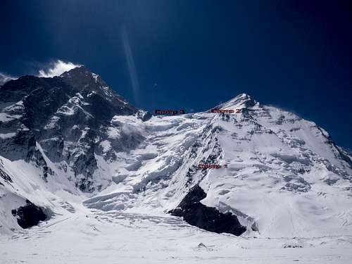
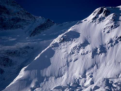
Camp 1 to Camp 2: Route to camp 1 is a nice warm up, best to come in acclimatized 5000m. This way we did not need to do additional carries or waiting. This is a 1000m of sustained ridge climbing. You spend you time walking along the cornice on a fixed line of varying degrees of wear. You have some braided nylon ropes that shed as you go up or down but most are newer modern ropes. It is about 6-8 hours for most teams to go up and 2-3 to come down. About 32 rappels, some of which you can just tag on a safety line and walk down if you are feeling confident. Some people did carries in four hours while others opted for longer days doing a full carry up. Can form a bottle neck on fixed lines slowing ascent or descent to a crawl. Plan accordingly and get started early. {4600m-5600m}
Camp 2 to Camp 3: This carries you up and over Csepajer 6120m then back to the West Saddle 5800m. Camp 2 is slightly sheltered and being close to fixed lines all the way down to Camp1 is the last place for safe descent even is bad weather. The climb to Peak Csepajer is strait forward but the traverse to Camp 3 is committing having to travel across the corniced ridge with no easy route off the mountain. {5600-6100-5800}
Camp 3 to summit: Due to bad weather our team, and all the other teams did not have a chance to attempt the summit during the 2013 season. But based on other descriptions I heard you would climb to about 6400m then ascend a snow couloir to summit. Very exposed and windy under most conditions. There is a small snow ledge aka Camp 4 around 6200m enough room for two tents.
Standard mountaineering gear: Crampons, Ice axe, Hard Shells, Warm boots, Down jacket, -20 degree F bag ( can be cut to a nice 0 degree bag if used in conjunction with other insulators and adequate insulation on ground. I used a Sol-lite Ridge rest and Neo-Air X-Therm). A strong tent that can stand up to days of high winds and snow loading. Figure 8 device and ascender.
http://itmc.centralasia.kg/index.php/en/