
-
 6091 Hits
-
 81.18% Score
-
 13 Votes
|
|
Mountain/Rock |
|---|---|
|
|
47.56080°N / 11.20836°E |
|
|
Hiking, Skiing |
|
|
Spring, Summer, Fall, Winter |
|
|
6306 ft / 1922 m |
|
|
Overview
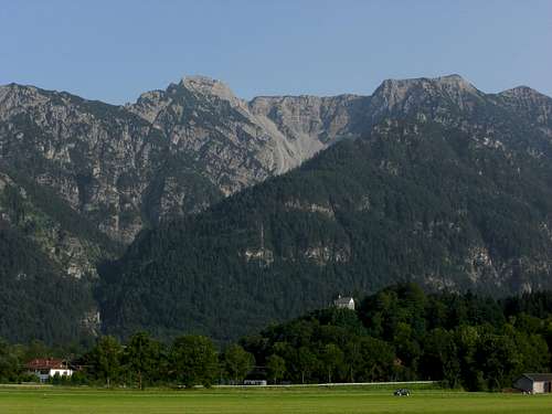
Hohe Kiste and Kistenkar cirque as seen from Eschenlohe
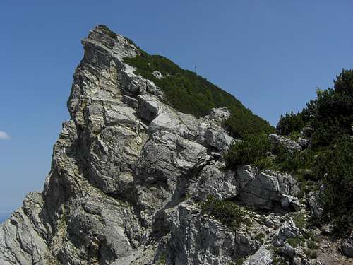
Despite of being the second lowest summit of Estergebirge, Hohe Kiste is a very frequented mountain. Hohe Kiste summit is the prominent looking north end of the Estergebirge main ridge, culminating at 1922 m, about 1300 m above the village of Eschenlohe. The summit block looks like a case or a chest, built up of rather solid limestone, thus giving the denomination of this mountain.
Four main routes are leading to the top of this “high chest” and there is a wellknown MTB route, too, which adds to the attraction of this summit. Located north of Archtalkopf and west of Platteneck and Kesselkopf, two minor summits of Estergebirge, Hohe Kiste dominates the northern part of Estergebirge and the huge sinkholes within the karst plateau of this part of Estergebirge.
Hohe Kiste is an excellent lookout point for Ammergauer Alps, Karwendel ranges and Bavarian mountains. The views to the south, however, are blocked by much higher summits of Estergebirge, Krottenkopf, Bischof and Oberer Rißkopf. On clear days, the upper Bavarian lowlands with the lakes region (Ammersee, Starnberger See, Staffelsee) are unfold like a huge map.
My preferred time of the year for Hohe Kiste is july. There is an abundance of alpine flowers on the slopes, many rare orchids and mountain roses (Rhododendron ferrugineum) among them, and the air is full of the buzzing of insects.
Getting There
There are two main valley trailheads for Hohe Kiste:You reach Eschenlohe by car
 Wildflowers at Hohe Kiste |  Rugged dolomite at the north slopes of Hohe Kiste |  Orchid |
Summit as seen from Kistenkar
You reach Wallgau by car
Railway
The railway München - Innsbruck gives access to the trailheads of Eschenlohe.
See the railway schedule here .
Regionalverkehr Oberbayern (RVO) runs the public bus lines in the valleys around Estergebirge. The lines number 9605, 9606, 9607 and 9608 do the service between Ohlstadt, Garmisch-Partenkirchen, Klais and Wallgau.
See the schedules here .
Routes Overview
Five main routes are leading up to the top of Hohe Kiste:In addition, there is a wellknown and frequented mountainbike route
Pustertal route:
Trailhead: Eschenlohe, end of Schellenbergstraße; hikers parking area (free)
Trail numbers: 15 or HSt (Hahnbichlsteig), 474
Route Details:
From Schellenbergstraße trailhead take the forest road in southern direction to the first switchback, pass the route barrier and follow the broad forest road up and into Pustertal Laine valley.
Midway into Pustertal Laine a trail leaves the forest road to your right (signposts); follow that trail up to a trail junction with Hahnbichl trail.
Hahnbichl trail is an alternative to the forest road; for that trail leave the forest road after the road barrier on the first road which branches off to your right (signpost: “Hahnbichlsteig”). Follow that road up for quite a while until another signpost shows you a steep and narrow trail which winds up the slopes of Zwölferkopf, a secondary summit of Hohe Kiste. Cross another forest road and follow the narrow trail until it reaches a third forest road. Follow closely the red marks and signposts as there is an abundance of forest roads and trails crisscrossing the mountain woods. At least the trail runs nearly level to the trail junction with the first, above described route.
The trail ascends Pustertal Laine, crosses some creeks and arrives at the meadows of Pustertal hunter cabins, a very nice place for a break. Follow then the trail through dwarf pine thickets up the upper Pustertal valley and the Pustertal cirque to the col east of Hohe Kiste summit, where you reach the trail number 471 / 472 to Weilheimer Hütte. Follow this trail to your right until you reach the signpost, indicating the short and steep trail to the summit.
 Pustertal |  Pustertal |  Wildflowers |
Kistenkar route:
Trailhead: Eschenlohe, end of Schellenbergstraße; hikers parking area (free) or end of Siemensstraße / road after the Eschenlohe sports ground
Trail numbers: no trail number
Route Details:
From Schellenbergstraße trailhead take the forest road in southern direction to the first switchback; leave the road to your right and follow another road until you can descend into the mostly dry and scree filled streambed of Urlaine creek. Cross the streambed and follow some tracks up the other side to a forest road leading to the Eschenlohe sports ground. Turn left and follow a trail until you reach the trailhead Siemensstraße.
Follow the forest road in southern direction for about 200 m. Turn left onto a steep forest road (no signs or markings!) and ascend on that road to its end. A narrow trail starts there, zigzagging first up the slopes then traversing high above Urlaine / Achtal gorge into Kistenkar. Pass by a hunter cabin and, some switchbacks later, arrive at the timber line and the lower Kistenkar cirque. There are nearly no signs or marks for this lower part of the ascent; from now on the route is cairned.
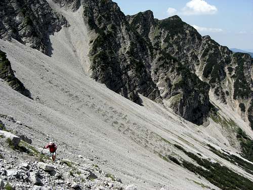
The first half of the Kistenkar cirque ascent the trail is quite obvious. Then the trail disappears from time to time; follow best the meadow patches in the middle of the cirque up to a huge, steep and deep erosion gully. Soon the cairns are on the other side of that gully. I found it best to ascend on the right (orographic left) side of the gully until a traverse is secure. Join then the steep, cairned track on the other side of the gully leading you up to the final rock barrier in front of the col west of the summit.
Follow a short ledge on your left until a short rock scramble brings you up to easier terrain; follow the cairned route in some minutes up to the col south of the summit where you join trail number 471 / 472 from Weilheimer Hütte. Turn left on that trail and, after some 50 m, turn left again (signpost: “Hohe Kiste”) onto the summit trail which leads steep up to the summit cross.
 Urlaine / Archtal valley |  Kistenkar cirque |  Upper Kistenkar cirque scramble |
Wallgau routes:
Trailhead: Wallgau, Seestraße, parking areas (Wildsee route) or Wallgau center or Sonnleiten (Krüner Alm route)
Trail numbers: 470, 471, 472, 473 from Wallgau Seestraße trailhead;
450, 454 / S1123 from Wallgau, Sonnleiten trailhead.
Route Details:
Wallgau Seestraße trailhead: Follow the forest roads number 470 or 471 into Schwarzbach creek valley. At the second trail fork of road number 470 and 471 take the latter road to your left and follow that road and alter the trail up to Wildsee and into Wildsee valley (Wallgauer trail). Above timberline you reach the forest road number 15 from Eschenlohe. Follow that road to its end and then trail number 471 to the short summit trail to Hohe Kiste.
Wallgau Sonnleiten trailhead: Follow the trail number 454 / S1123 (partly a forest road) up to Wallgauer Alm and Krüner Alm. Alternatively follow Finzbach creek on trail number 415 in western direction until you reach the endpoint of Finzbach canyon. Take forest road 450 to Krüner Alm.
From Krüner Alm follow trail 454 up to the trail to Weilheimer Hütte; the trail junction is just below Schindlerskopf. Go east / right on trail 471 to the summit trail and ascend Hohe Kiste.
 Upper Wallgau route |  Krottenkopf and Weilheimer hut |  Pustertal(left) and Wallgau route (right)as seen from summit |
Route from Weilheimer Hütte:
Trailhead: Weilheimer Hütte
Trail numbers: 471 / 472
Route Details:
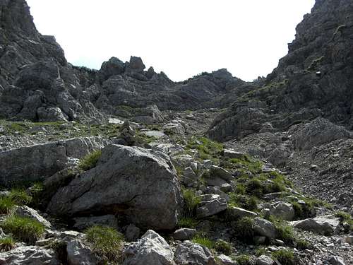
From Weilheimer Hütte go north and follow the trail through dwarf pines high above the huge karst plateau and sinkholes, crossing the east slopes of Oberer Rißkopf, Schindlerskopf and Archtalkopf to the col above Kistenkar cirque. Follow the steep summit trail which is indicated about 50 m after passing Kistenkar col.
 Obstacle on the MTB route |  Krottenkopf and Weilheimer hut route |
Mountainbike route:
Trailhead: Eschenlohe, end of Schellenbergstraße; hikers parking area
Trail numbers: 15
Route Details:
From Schellenbergstraße trailhead follow the forest road to the south, cross the road barrier after the first switchback and stay on that broad forest road, which first ascends in eastern direction, then turns south, crossing Pustertal Laine valley, circles around a minor ridge coming down from the Estergebirge plateau and ascends west of Simetsberg to a col east of Kesselkopf, a minor summit at the north end of Estergebirge plateau.
The road then turns to western direction ascending to Rechtler Hütte and to a last switchback at a hight of about 1720 m, somme 200 m below the summit. Leave your bike there and ascend on the trail number 472 in direction of Weilheimer Hütte. Soon you reach the col at the top of Pustertal cirque; traverse the summit slope south of the summit until you reach the trail junction with the summit trail (signpost). Follow that summit trail steeply up to the summit cross.
Red Tape & Accommodation
Steep Kistenkar
No red tape.
You find accommodation at:
Mountain huts:
Gear & Mountain Condition
Hohe Kiste is a nice hike during spring, summer and autumn. In winter and early spring Hohe Kiste can be tackled with snow shoes, too.Normal hiking gear and good boots are sufficient. Gaiters can be useful during a springtime hike.
Kistenkar cirque is a well known ski tour which is, however, not very popular any more. Due to the difficult approach above Urlaine canyon and the steep cirque, Kistenkar is not an easy ski tour. You need full ski tour and avalanche gear and a good knowledge of the snow condition in the cirque.
Current Weather:
Maps & Guide Book
Steep Kistenkar
Maps
Alpenvereinskarte, scale 1 : 25.000
Blatt BY 9: Estergebirge, Herzogstand, Wank
DAV, 2009
Toporaphische Karte von Bayern, scale 1 : 50.000
Karwendelgebirge Werdenfelser Land
Guide Book
There is no special guide book available for Estergebirge.