
-
 8855 Hits
-
 84.82% Score
-
 19 Votes
|
|
Mountain/Rock |
|---|---|
|
|
47.32740°N / 12.61462°E |
|
|
Hiking, Skiing |
|
|
Spring, Summer, Fall, Winter |
|
|
7379 ft / 2249 m |
|
|
Overview
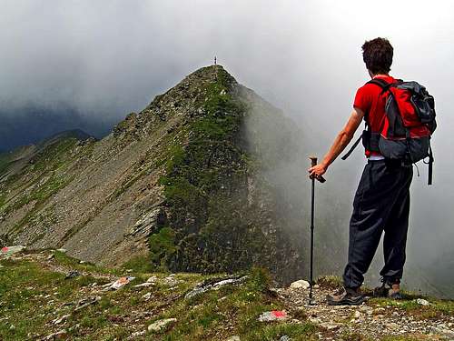
Descending from Hochkogel towards Hochsaalbachkogel
Allowe me to post a fairly insignificant summit, which is still the highest one above a very popular 'Pinzgauer hike', in Kitzbuehl Alps. All summits in the southern streak offer great panoramas - especially beautiful are the vistas on glaciers of Hohe Tauern, just across the valley of Salzach. So does Hochkogel. If you want to do a fairly easy, panoramic hike on a grassy mountain, Hochkogel is for you. With some logistic you can also extend the tour to virtually any duration.
Hochkogel is a typical mountain, which is in summer taken-by, while doing a long-distance hike along the mountain streak. In order not to repeat information, please visit the sister page of Hochkogel - The Pinzgauer Spaziergang (walk) route page. There are some ideas about possible options and some more pictures. There are also:
> main geographic features of the area,
> logistic of the hike,
> supporting huts and bivouacs,
> route description and timing.
The Narrow Hochkogel Area

Descending from Hochkogel summit view
The small Hochkogel group consists of three typical 'Kitzbuehler' summits, delimeted from the rest of the streak on the east by Klinglertoerl, 2059 m, and on the west by Medalscharte, 2058 m. Above Klinglertoerl the summit of Hochkogel, 2249 m, is rising rather steeply. Steep are also the northern slopes, towards Saalbach valley. The southern side of Hochkogel has a rounded ridge, which descends towards Salzach valley - over these slopes the Pinzgauer Spaziergang goes horizontally. Towards the west from Hochkogel the main ridge descends and soon rises on the neighbouring, sharp-looking Hochsaalbachkogel, 2212 m. Even further towards the west is the unsignificant, rounded Medalkogel, 2123 m. A marked path crosses all three summits.
Getting There and Routes

Hochkogel from the west
You reach the Pinzgau valley (Zell am See, Mittersill) from the highway Salzburg-Villach, exit Bischofshofen, driving towards the west. From the west you get there from Innsbruck via Mayrhofen and Gerlos Pass. From the north you get there from Kitzbuehl over Pass Thurn. And from the south you get in Pinzgau by any of the three options of crossing Hohe Tauern. Similarly, you can start the tour on the northern side of the mountain streak, in the valley of Saalach. The well known tourist resorts there are Saalbach and Hinterglemm. And even logistic is similar - you can go up with a cable-car on Schattberg and continue by the ridge towards the south.

The main mountain streak with Pinzgauer Spaziergang

Descending from Hochkogel east ascent
Although you can ascend Hochkogel from any direction, the most recommendable might be the approach from the east, where you use the cable-car on Schmittenhoehe and the Pinzgauer Spaziergang (trail). The cable-car drives in summer each half an hour from 8:30 till 17:00. The cost is 16€ (2007).

The view on Hohe Tauern
Rough time-table for possible ascent routes:
> 4 h from the east, from Schmittenhoehe,
> 4h from the west, from Buerglhuette,
> 3h from the north, from Schattberg,
> 5h from the south, from Niedernsill.
All routes are easy, only the trail over the west ridge (crossing Hochsaalbachkogel) is fairly exposed and on a few places also protected with steel cables. You can see a detailed map (1:50.000) on-line on: http://www.austrianmap.at/.
Red Tape
No limitations
Mountain Huts
- Below Schmittenhoehe, on 1700 m there is Pinzgauer Huette, opened from start of June till end of October (and also in winter).
- At the end of Muehltalbach, on 1699 m there is Buerglhuette, opened from start of June till end of September.
- On Klammscharte, on 1993 m, there is a small, permanently opened shelter (hut).
- South of Klinglertoerl, on cca 2000 m there is a small, permanently opened shelter (hut).
- On both sides of the ridge, also on altitudes up to 1800 m, there are many mountain pastures, where you can find private huts.