An Approach
![Hochkalter]() Hochkalter and Blaueis
Hochkalter and Blaueis
For many years
Hochkalter was on my summit list. Many years I postponed this tour because I thought that:
I thought wrong!
During our spring ski tour to
Hocheisspitze my colleague Reinhard suggested a trip to
Hochkalter via Blaueis glacier in one day. This should be a sort of training tour for our 2009 Switzerland plans. He had done this trip several times before and told me that early in the summer the difficult bergschrund should be packed with snow and the
northeast arete is not more than UIAA grade II. This was surprising news to me as I always thought that this classic summit route was out of bounds for me.
Hochkalter is the highest point of the Berchtesgaden subgroup with the same name and a very prominent peak. The Blaueis glacier, fed by avalanche snow and the huge snowdrift in winter lies in a northern exposed, deep cirque which is surrounded by other impressive peaks (
Schärtenspitze,
Blaueisspitze,
Rotpalfen,
Kleinkalter) and thus sheltered from too much heat and rapid melting in the summer. It is the northernmost glacier of the Alps and one with a very low exposure: it starts actually at about 2000 m and reaches up to Blaueisscharte, 2400 m.
We planned this mixed glacier and rock route as our ascent route, which was undertaken first 1874 by J. Grill and E. Richter. The descent was planned via
Ofental; this is the western cirque of Hochkalter and an easy and quick return route. Reinhard told me that the ascent will take its time, 5 to 6 hours and the descent 4 more hours. So mid of june 2009 we checked the weather forecast carefully and there it was: a thunderstorm free Sunday, the 14. of june 2009, an excellent summit day.
Getting started
![Watzmann, Hocheck]() Hochkalter as seen from Watzmann
Hochkalter as seen from Watzmann
I love my alarm clock when it rings at 04.45 a.m. At a time when the last night owls stagger home I tried to swallow down some porridge and tea. One hour later I picked up Reinhard and we headed on the highway A 8 to Ramsau and
Hintersee where the trailhead for Blaueishütte is located. You should start not later than 07.30 a.m. - we managed 07.15 a.m. Narrow escape!
First there are several forest roads leading up through thick wood to
Schärtenalm, a sort of mountain log cabin inn with a nice terrace and an even nicer view down to
Hintersee valley and to the
Reither Alm range with
Wagendrischlhorn and
Stadelhorn, the main summits. Mouthwatering scents came wavering out of the kitchen, it smelled like roasted meat and Apfelstrudel. I imagined me sitting on the terrace with a Weißbier and a good piece of cake - and so it was better to head on immediately.
Five minutes after passing Schärtenalm the road turns round a corner and reaches the lower part of Blaueis cirque with a first breathtaking view of Hochkalter summit and our ascent route. It looked very impressive.
Blaueishütte was visible standing at the timberline high above the valley. We reached the hut about two hours after our start and as the sun had just touched the hut grounds we sat down in front of the hut for a bite and a swig out of our bottles.
It was a beautiful morning, fresh and a little bit windy. The hut keeper prepared the terrace for the day guests, several training groups were hanging in the rockwalls surrounding the hut. Their commanding shouts were filling the morning air. High and steep in front of us Hochkalter with the white mantle of Blaueis glacier, flanked by the bold spires of Schärtenspitze and Blaueisspitze. What a view. Just sitting and looking the whole day .....
The Glacier ascent
![Hochkalter]() Blaueis glacier (14-06-2009)
Blaueis glacier (14-06-2009)
But we had to move on. So we left that comfortable place, passed the ground of the old hut which was destroyed by an avalanche and started the ascent to the lower end of Blaueis glacier.
There were some spots already visible on the higher parts of this little glacier. We passed some more training groups (I counted 6 groups - a good income for the hut keeper) and reached at last the snow of the glacier with two other mountaineers who obviously had the same destination. We then started our ascent on the shallow snow field which gradually gets steeper and steeper with the height.
There are some glacier polished rocks sticking out in the middle part of the glacier. This is due to the glacier melting in the whole alpine region. Those rocks can be traversed quite easily from the right up to the left. Some days later I learned that the average thickness of Blaueis glacier is only 8 meters - not much to resist global warming.
The spots which we had seen high on Blaueis glacier where three other mountaineers who had obviously summited
Blaueisspitze, the ski summit of the Hochkalter. Blaueisspitze is only 10 minutes away from the Hochkalter route and can easily be summited “along the way”. Now they were skiing down with several cries of delight. I looked at them grudgingly, this really must be fun ....
![Hochkalter]() Steep part of Blaueis glacier (14-06-2009)
Steep part of Blaueis glacier (14-06-2009)
We instead had reached the steep upper part of the glacier. The guide book says it is 45 to 50 degrees but I think that that´s a bit overdrawn. It is steep, that for shure, but I estimated 40 to 45 degrees, not more.
The snow was good, we didn´t put our crampons on. We had ski pokes and an ice axe and this was sufficient for the ascent on the glacier so far. Step by step the views were getting better and better, the steep and impressive rock faces which surround this little glacier, the spires and summits of Schärtenspitze, Blaueisspitze, Hochkalter, Kleinkalter and Rotpalfen were standing high in the skies and on the ridge between Rotpalfen and Hochkalter were visible several mountaineers climbing Hochkalter on the normal route.
At last we reached the upper rocks and the bergschrund. This really is the crux of the whole route. As long as the bergschrund is filled up with snow, there is nearly no difficulty to go on. If the bergschrund is open, which happens probably in august, september and october, you will have trouble to gain the upper snow field.
![Hochkalter]() Bergschrund of Blaueis glacier (14-06-2009)
Bergschrund of Blaueis glacier (14-06-2009)
We passed the bergschrund and climbed up on a hard ice shield (this time with crampons !) to a rock ledge which leads up to the left and to the upper snow field. This was astonishingly easy (less than UIAA grade I). You do not see this ledge until you have reached the bergschrund. Even some steps below the bergschrund you aks yourself how you will be able to overcome the rockface, the upper limitation of the glacier. If the bergschrund is open - and it then is a deep and wide one - you will not be able to gain the left ledge. You have to climb the rockwall on the right of the ledge, which is probably UIAA grade III and needs belaying !
We, as I told already, where lucky and did overcome this obstacle quite easily. Some minutes later we were standing below the col between Blaueisspitze and Hochkalter with a 200 m rock climb to do.
The rocky ridge
![Hochkalter]() Northeast arete (14-06-2009)
Northeast arete (14-06-2009)
If you look from below the col onto the east ridge of Hochkalter you will easily recognize a steep chute dividing the broad ridge in two parts: a steep rock slope on the right of the chute and a sort of arete on its left, ending at a wild looking rock tower below the summit.
The best way to ascend is to use the left arete.
We went up to the highest point just below the beginning of the left arete. The other two guys were already there gearing up with ropes and things. Reinhard told me that he never did belaying on this route and that it is not necessary. The first bit didn´t look difficult, just a rocky chute left of the steep arete with some nice climbing at the upper part. We followed the other party up the chute and at its end to the right up onto the arete. After some easy rock scramble there were these two rock walls, each about 10 to 20 meters high, very steep and exposed but with good steps and holds for the hands (UIAA grade II and II+). The rock was excellent to climb and it really was fun. We overtook those two guys - belaying is save but time consuming - and were overtaken by two more experienced mountaineers who did the whole Blaueis frame, which means the whole arete from Schärtenspitze to Rotpalfen (UIAA grade IV and V in parts).
![Hochkalter]() Subsummit of Blaueisspitze (14-06-2009)
Subsummit of Blaueisspitze (14-06-2009)
After those two little rock walls we climbed up the arete on now easier terrain to the beginning of the tower. There we traversed right and thus bypassed the tower by climbing up again as soon as the terrain was easy enough. This part mostly is UIAA grade I with some scree on the ledges so the use of a helmet makes sense.
Two huge cairns are marking another short traverse into the uppermost part of the above mentioned central chute. The route uses the last part of this chute to gain a notch right below the summit. The chute was still snow filled but the snow was not iced or hard and good to step in and up.
The views from the route down into Blaueis cirque and the surrounding peaks are just marvellous and we took our time to just look and enjoy. The views from the notch were even more spectacular and after the last rock wall between the notch and the summit (UIAA grade II again) there was a breathtaking 360 degree view waiting for us.
Even more impressive was another rock tower in the summit arete, slightly overhanging and looming over the southeast walls of Hochkalter. As this is the part where huge rockslides were thundering down into Wimbachgries valley recently we wondered how long this tower will withstand the gravitation forces and erosion.
![Hochkalter]() Climbing northeast arete (14-06-2009) Climbing northeast arete (14-06-2009) | ![Hochkalter]() Climbing northeast arete (14-06-2009) Climbing northeast arete (14-06-2009) | ![Hochkalter]() Summit rockslide area (14-06-2009) Summit rockslide area (14-06-2009) |
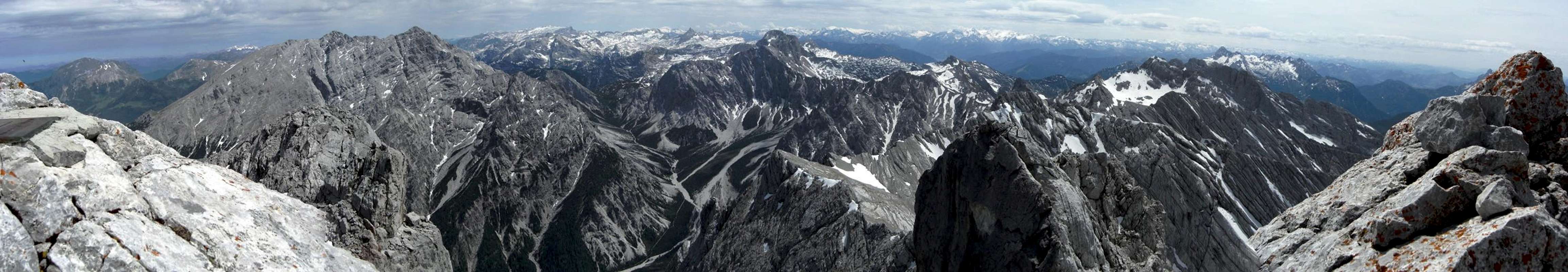
It took us 6 hours and more than 1800 vertical meters to summit and so the summit break was well deserved. For about an hour we were lying lazily in the sun, eating, drinking, looking and feeling happy.
Hochkalter summit panorama (14-06-2009) |
Descending .....
![Hochkalter]() Ofental descent(14-06-2009)
Ofental descent(14-06-2009)
In the afternoon some clouds were drifting in from the northwest, hiding the sun and bringing some chilly gusts of wind. After a last panorama view we started our descent via Ofental route.
This route uses the southwest slopes and chutes of Hochkalter down into Ofental, another deep cirque on the west side of the mountain. The trail winds itself down through steep scree filled chutes and rock passages with easy but somehow exposed rock scramble. Then, still high above Ofental, the trail traverses to the left, using ledges and polished rock slabs and again steep rock passages. I found that this was a trail rather for a descent than an ascent.
Finally we reached the still snow filled Ofental and happily slided down the snow some 400 meters of altitude difference, a fine variation after the steep rock and chute scramble.
![Hochkalter]() Reither Alm rockwalls (14-06-2009)
Reither Alm rockwalls (14-06-2009)
At last we reached the dwarf pine zone with blossom adorned meadows were we took a short break admiring the impressive rock faces of Stadelhorn and Mühlsturzhörner, two of the highest peaks of Reitheralm range just across the valley.
Then there was the long ascent into the Hintersee valley waiting for us. Through denser and denser woods the trail winds itself down to the valley in sheer neverending switchbacks. I was happy to gain the valley ground again. From the Ofental trailhead it was a half hours stroll back to the car in the warm evening sun.
To finish this long 10 hours day we had dinner on a terrace above Lake Hintersee and we savoured the peace and calmness of this summer evening ( and the innumerable mosquitos savoured the fresh blood of two exhausted but happy hikers....).
![Hochkalter]() Loferer Steinberge(14-06-2009)
Loferer Steinberge(14-06-2009)


Comments
Post a Comment