
|
|
Route |
|---|---|
|
|
45.22620°N / 117.1715°W |
|
|
Hike |
|
|
Half a day |
|
|
Walk up |
|
|
Summit Elevation of Hidden Peak is 9495 feet, not 9460 as shown above.
Approach
From Enterprise Oregon, go south to Joseph and go right through town (obeying the speed limit due to local fundraiser who uses a radar gun) following the signs to Lake Wallowa State Park, about 6 miles. At a junction that leads right into the State Park, take the left and go about 1/4 mile or so to a parking lot for the Mt. Howard Tram. The tram starts up at 10:00 a.m. and costs 19 bucks for an adult at this writing. A 15 minute ride puts you at the top and the TH for East Peak and Hidden Peak. Want exact coordinates? Click here The base elevation is 4400 feet so riding the tram will whisk you up to the 8200 foot mark, saving you 3800 feet of elevation gain and making it possible to get two or three peaks in one effort. Or you can take the trail that you will find at the end of the road that that continues on past the Mt. Howard tram turnoff and parking area. Your call.
Here's an idea of other things to do in the area by a touron and I add this in case you would like to take a non hiking spouse or non hiking children along with you so that they will have something to do while you are doing the peaks
Route Description
I know, I know, how lame is it to ride a tram up to access a peak?
Well, there is a nice trail that you can take, but I offer this in the spirit of "hey, I ain't gotta lotta time and I want to hike something"
Some may think this is cheating to ride a tram up but it doesn't take you all the way and does put you in position to pull off a two peak (or even three peak) day
if you start up at the 10:00 a.m. time. As you exit the tram, a large information sign is available from near the outdoor restrurant and you can follow the path that leads to near the top of Mt. Howard (just about 40 feet away from the path). The point you are looking for is designated as the Summit Overlook (see map at link)
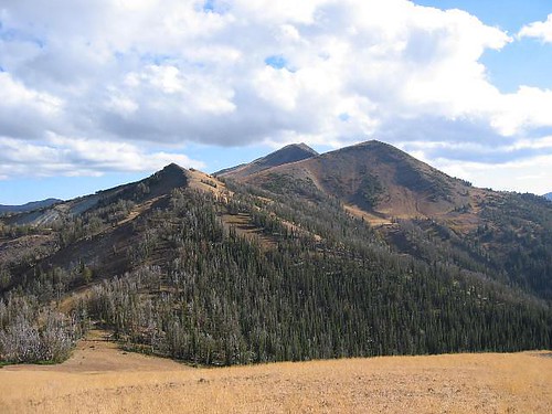
As you look south, East Peak dominates the view. Drop down to the path that is in the saddle below and follow the path towards the peak. It is 2 miles to the summit from where you leave Mt. Howard and the elevation gain is 1800 feet (allowing for the loss in elevation from Mt. Howard to the saddle). After you drop down into the saddle noted, the trail ascends up to this spot (see map) where you continue on to this junction which isn't marked on the map but is definite and very obvious (see map) . Taking the right fork at this unmarked junction, the route follows the ridge, staying to the east side of the ridge most of the way to the summit.
Only a cairn marks the summit but the view is excellent.
Hidden Peak
From the top of East Peak, drop down (losing 360 feet) to the saddle between East and Hidden Peak by following the ridge. From the saddle, located at 9000 feet, continue back up a fairly obvious route to the summit of Hidden Peak, a climb of about 500 feet from the saddle mentioned. Interestingly enough, Hidden Peak isn't named on the topo map but that isn't the reason it is called Hidden.
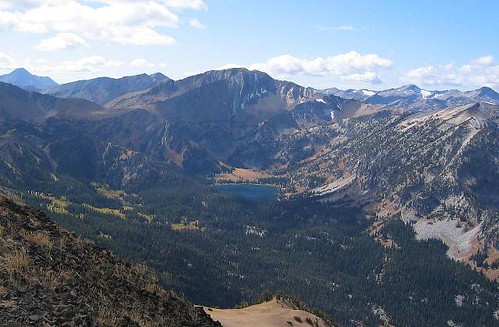
It is called Hidden as East Peak blocks the view of it from the Mt. Howard area although is obvious from the river valley trail below. On top of Hidden Peak, a large summit cairn is found along with an ammo can containing a register that dated back to 1989. Views south to Aneroid Peak, Aneroid Lake, Petes Point, Sentinal Peak are outstanding as well as views west to Eagle Cap, the Matterhorn, Sacajawea, the Hurwal Divide and Chief Joseph Mtn await you. Outstanding. Views east look into Idaho and the Seven Devils area if you know where to look.
Add another hour and you can continue on to Aneroid Peak. Allow enough leeway however to enable you to return to the tram for the ride down (last one is at 4:45p.m.)
Time to East Peak from the Mt. Howard tram station: 1 1/2 hours for a moderate hiker Elevation gain 1600+ in 2 miles
Time to Hidden Peak from East Peak 1 hour for a moderate hiker. Add another 500 feet of elevation gain and less than a mile. Round trip to Mt. Howard Tramway is 6 miles and about 2100+ feet.
Time to Aneroid from Hidden Peak 1 hour for a strong hiker. Add 3 more miles to the round trip making it about 9 miles overall and an additional 750 feet of elevation making the whole trip to Aneroid and back slightly less than 3000 feet of elevation gain. Not a bad deal for three peaks.
Allow 2 hours back to the Mt. Howard tram from the summit of Hidden Peak by contouring around the east side of East Peak. Drop to the saddle between East and HIdden Peaks and a faint but obvious use trail can be found that allows you to contour around the east side. Aim for this spot (see map) which puts you back on a decent trail again leading back to where you came from originally. Or you could go back up over the top of East Peak
if you want the additional exercise but that once again will be your call.
Should you go on to do Aneroid peak, add a couple of hours to your overall time calculation in order to return to the tramway for the ride down, remembering that the last ride down is at 4:45 (get exact time from the tram operator before you hit the trail)
My partner did all three peaks and made it back to the tramway by 4:15 p.m. but he is a strong hiker. So if you can make the top of Hidden Peak by 1 p.m., you should be able to add Aneroid and return in time for the tram ride. Again, your call.
The view to Aneroid Lake and Petes Point
 |  |
Essential Gear
Good hiking shoes, plenty of water (none in mid to late summer) and sunscreen if you burn easily. Figure the hiking times given in the route description section to apply to mid and late summer. Snow will change the time table so plan accordingly.
Dennis Poulin gets ready to head for Aneroid, his 72nd Oregon Prominence Peak. One left to be the first to finish the whole state.
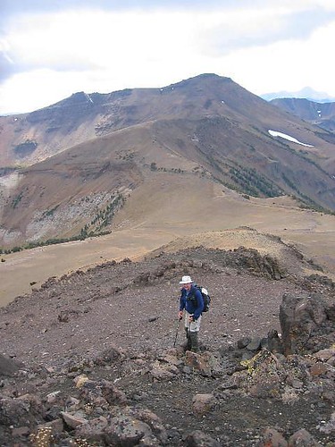
This pic shows the whole route over to Aneroid Peak
Miscellaneous Info
If you have information about this route that doesn't pertain to any of the other sections, please add it here.
Note that Hidden Peak is referred to as Peak 9495 in Barbara Bond's book, "75 Scrambles in Oregon"
Here's is an entry of the only person I knew in the register. He used the tram to get all 3 peaks
