-
 8358 Hits
-
 89.01% Score
-
 28 Votes
|
|
Route |
|---|---|
|
|
43.37712°N / 110.48691°W |
|
|
Scrambling |
|
|
Summer |
|
|
Most of a day |
|
|
Class 3 |
|
|
Peaks visited
Overview
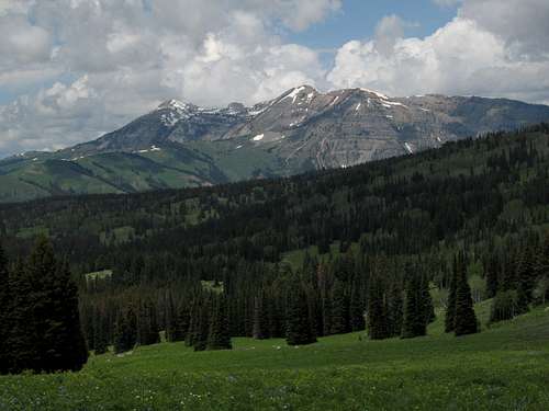
Interested in spending a day climbing several unnamed summits, even though some are not on any lists of ranked peaks, in a mountain range that is every bit as spectacular as any other in the Greater Yellowstone Ecosystem but far less-visited than the ones that dominate the postcards and the calendars? Do you like summits that appear to be untouched by people? Do you enjoy the sense of being all alone in a vast wilderness? Up for a little exposed scrambling on crappy rock?
If you answered “Yes” to all of those questions, you will love this route.
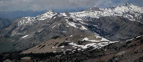
This outing visits a group of summits that are part of a long ridge complex in the Gros Ventre Wilderness. It traverses terrain that almost no one visits.
Peaks visited
Getting There
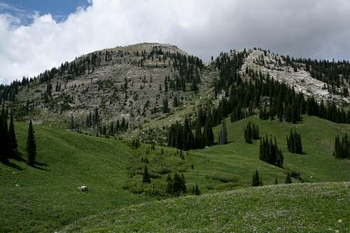
About 11 miles southeast of Hoback Junction, look for a signed road heading north into the Granite Creek Recreation Area. This gravel-and-dirt road, which can be a little rough but is still passable for most passenger vehicles, follows Granite Creek for 10 miles to Granite Hot Springs, a popular spa (admission fee required). Along the way there are spectacular views of Granite Creek and the Gros Ventre Range.
7.5 miles up the road, look for a spur that makes a bridged crossing of Granite Creek. Turn here and follow signs for 0.1 mi to a trailhead.
Granite Highline Trail begins right across the road from the spur. In July 2010, there was no sign, but the trail was obvious to see. I actually parked a little off the road but not blocking it, just south of the trail’s beginning, to save myself a little walking and elevation gain.
Route Description
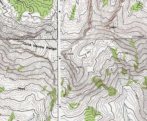
Distance to Boulder Creek: 3.8 miles
Distance to Point 10,700, including a climb of Point 10,405: 2.5 miles
Distance to Terrace Mountain’s Highpoint: 1.5 miles
Distance to Granite Highline Trailhead: 4.9 miles
Total Elevation Gain (approximate): 5000'
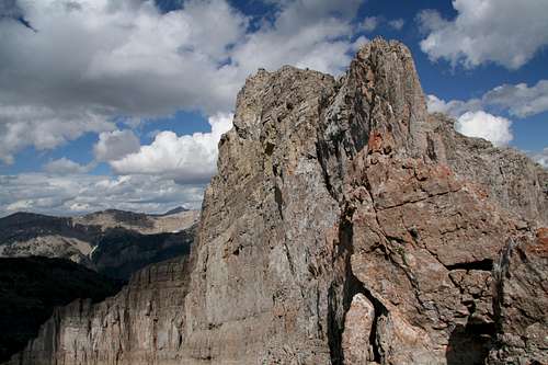
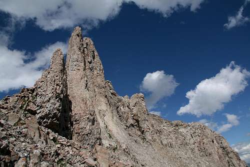
Hike the Granite Highline Trail (starting elevation 6800’) almost four miles (my GPS device gave me 3.8, and finger measures on a map suggested about 4.5) to Boulder Creek at 8300’. Leave the trail and ascend a broad chute just right (east) of Points 10,405 and 10,285. Your destination is a saddle at about 10,150’, but you can’t see it until you get past the trees high in the chute, and then it is an easy Class 2+/3 scramble to the saddle. From the saddle, follow the ridge southeast to Point 10,405. From some angles, the summit looks imposing, even technical, but it is in fact as easy as Class 2. The summit is a small, airy location, so make sure you watch your step as you admire the scenery.
Leave the trail here.
As a variation, before reaching the saddle, you can climb straight to Point 10,285 (some Class 3 up to the summit area, and the summit is a walk-up with a great view of Point 10,405) and from there traverse northwest to Point 10,405.
From the trail to the summit, the elevation gain is about 2100’.
Point 10,405
Back down, work your way along the north side of the peak; this involves some scrambling on loose rock, plus some elevation loss, but it is nothing too difficult or dangerous, and it ends soon. Once on better ground, just hike up the grassy slopes the rest of the way to the summit of Point 10,700. Enjoy the views of Pinnacle Peak, which at 5.4 on rotten rock is probably the hardest named Gros Ventre peak by standard route, and of the Tetons (as well as all the other fine Gros Ventre scenery).
From Point 10,405 to Point 10,700, there is about 500' of elevation gain.
Point 10,700
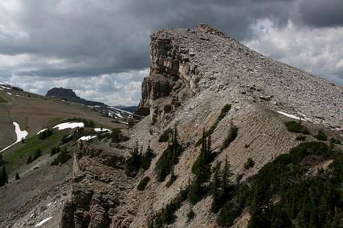
Now hike back to the saddle you originally reached from Boulder Creek. From the saddle, follow the ridge east to Terrace Peak. At one point, the ridge proper drips into a notch, and on the other side are sheer cliffs that will amaze and dismay at the same time. Traverse right on loose, exposed Class 3 terrain and scramble to the ridge above. It is a short, easy walk the rest of the way to the summit; elevation gain from the saddle is about 500'.
I thought the scrambling and the exposed traverse were a blast and all too short, but anyone uncomfortable with exposure is not going to like this section at all.
Scrambling area
Class 3 traverse, loose and exposed. Near the summit of Point 10,654.
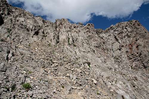
Near the summit of Point 10,654. Loose but easy.
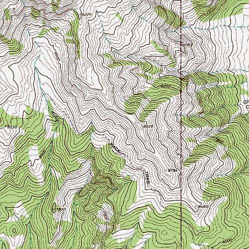
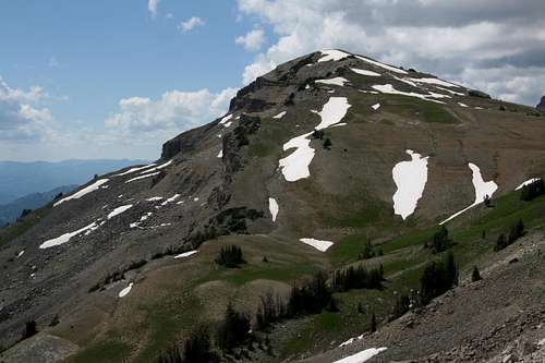
Descend to a saddle at about 10,460' and then ascend only about 160' to the second-highest summit (Point 10,623) of Terrace Peak.
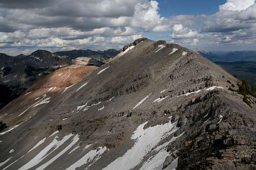
Point 10,623
If you feel like it, head east a short distance to get the third and lowest summit of the peak.
From Point 10,623, you have a choice; go back down to Boulder Creek (you can do so from this peak) and pick up Granite Highline Trail, or keep the altitude and great scenery for a while longer by following a long, gentle south-leading ridge. If the weather is cooperating, I highly recommend the second option.
Down
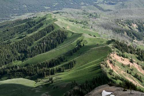
Drop down very steep terrain to Point 9220 and then a saddle above a drainage. You may encounter some very short spots of easy Class 3 scrambling depending on your exact route. If it gets harder than that, then you are making the route so. Now ascend the gentle ridge before you and follow it over Points 8928 and 8794. There is a game trail most of the way, and it helps with the dense vegetation. Somewhere between Points 8794 and 8460, drop to the Granite Highline Trail (expect steep bushwhacking, with plenty of deadfall) and follow the trail back to the trailhead. The distance will vary according to where you regain the trail, but it will be in the neighborhood of 1.5 mi.
Maps