Overview
![Pointe de Drône (2950m), Grande Chenalette (2889m)]() Grande Chenalette South Ridge
Grande Chenalette South Ridge is a mountain just to the north of
Grand Saint Bernard road pass, a high 2000er among 4000m summits. A chossy ridge connects it to the slightly higher
Pointe de Drône, so that both qualify for a short, but adventurous outing.
Grande Chenalette’s south ridge consists of the most solid rock in the area and it is home to a short , nervy ferrata, which scales the slabs on the ridge with the help of a few short ladders and half a dozen cables.
At 2889m,
Grande Chenalette is a dwarf among the 4000ers on the outskirts of
Valle d’Aosta but as the
Chenalette – Drône Ridge stands solitary, it offers wonderful views of the higher mountains. Additionally the location above
Col de Grand Saint Bernard reduces time and distance so that can be climbed in a good two hours.
Moreover, after traversing
Pointe de Drône, there is an option to descend to the
Lacs de Fenêtre, three glacier carved lakes on a plateau above
Val Ferret affording even more spectacular views than the summits. The return trip can be either done the short way through
Col de Fenêtre or the longo one through
Col de Bastillon and
Col des Cheveaux. If weather allows, go for the long route. It is worth the additional hours.
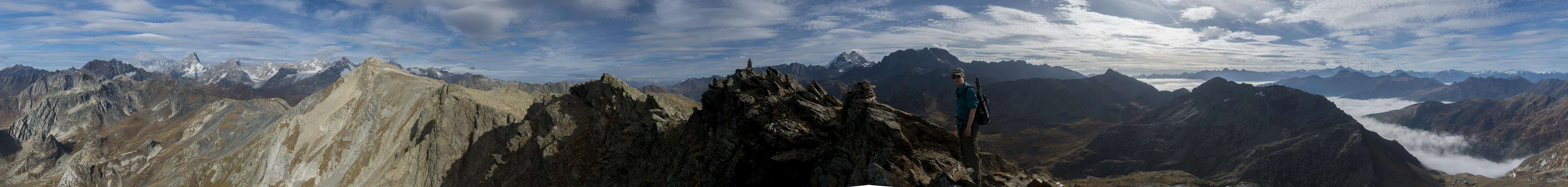
360° Summit panorama
360° summit panorama from Grande Chenalette |
Getting There
![Lac de Grand St. Bernard]() Lac de Grand Saint Bernard
Lac de Grand Saint Bernard
Starting point for the Grand Chenalette Climb is Passo Gran San Bernado (Grand St. Bernard, Großer St. Bernhard).
- From Italy
- Take motorway A5 to Aosta
- Take the exit Villair-Amerique to turn onto SS27
- After Saint-Oyen moke sure to stay on SS27 by turning of to the right (north) from the tunnel road
- Go all the way to the top parking on the shores of Lac Saint Bernard.
- From Switzerland
- Take A9 / E 62 to Martigny
- Switch to B21 south, passing Bourg-Saint-Pierre
- About 1 km beyond the village the road to Col de Grand Saint Bernard turns off to the right.
- Go all the way to the pass
Route
![Heading up the cable route]() On the slabs to Grand Chenalette
On the slabs to Grand Chenalette
The normal ascent starts directly at
Col de Gd. St. Bernard at the hospice on the swiss side of the pass directly behind the dog kennels.
From the kennels you wind up an abandoned ski run (the old chairlift stations are still around). On top of the run, beside the upper chairlift station there is a broad platform with beautiful towards
Mont Blanc and
Grandes Jorasses as well as the mountains on the south side of
Valle d’Aosta. Turning around and looking north you see the steep south ridge of
Grand Chenalette, across which an easy ferrata runs.
Pass the chairlift station and head for the marked starting point of the ferrata. The rock is solid and ladders and cables take you up the ridge. The crux is a slanting slab with a narrow crack, which you have to negotiate with the help af a somewhat loose chain. Once across, a few steep turns lead to the surprisingly small summit of
Grande Chenalette.
Enjoy the views!
Red Tape
No red tape to speak of even though you’ll be crossing the Italian – Swiss border a few times.
When to Climb
Best hiking season is August through October. In winter the summit can be reached from
Col de Fenêtre across
Pointe de Drône with tour skis.
Accommodation
Valle d’Aosta has a lot of hotels and apartments on offer, A good starting point for accommodation search is this site:
Weather Conditions
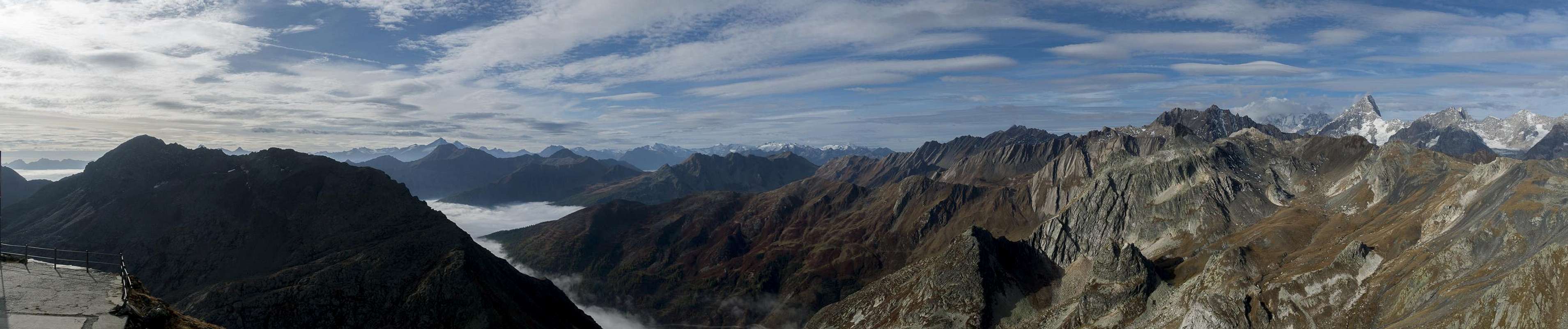
Panorama seen from the platform beneath the south ridge of Grande Chenalette |
Maps & Books
Maps
- Digital Maps
- Regular Maps
- Monte Bianco / Mont Blanc
Kompass Map WK85
Kompass Verlag
Scale: 1:50000
ISBN: 978-3850264976
Books
- Aostatal
Johannes Führer
Rother Verlag
ISBN: 978-3-7633-4033-0

 3209 Hits
 77.48% Score
 8 Votes
 Grande Chenalette South Ridge


 Lac de Grand Saint Bernard
 On the slabs to Grand Chenalette