With an approach of close to 15 miles leading to the base of Goode's 5800-foot north face, followed by fording a stream, bush-whacking, and a minor glacier crossing, it is normally done as a 3-day backpack from Bridge Creek along Highway 20. I completed the route car-to-car in 15h05 on a day in which I saw the sun for less than one minute, was rained on off-and-on, and got lost in the clouds on the descent. With good weather and knowledge of the route, this route could probably be done in 12-13 hours; an interesting project would be to link Goode with Logan, looping over Park Creek Pass before returning to Rainy Pass via Beckey's cross-country route to Logan.
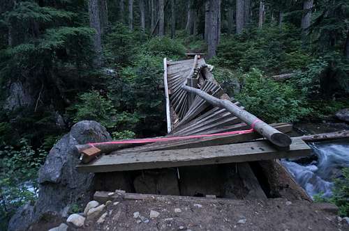
![Somewhat less Bridge-ful Creek]() Somewhat less Bridge-ful Creek
Somewhat less Bridge-ful CreekExpecting a big day, but not wanting to freeze in the morning dew, I started down the Bridge Creek trail at 5:05 AM. I normally dislike running first thing in the morning with a full pack, but I needed to jog the 10 downhill miles to the North Fork Bridge Creek cutoff to efficiently complete the route and, despite the smoke from fires near Twisp, even enjoyed most of the jog. The first bridge was a twisted wreck with flags leading to some other crossing, but I crossed the wreckage anyways.
As Bridge Creek drops into a slot canyon, the trail strays well above the creek until after the North Fork junction, crossing an extremely mobile suspension bridge along the way. The North Fork trail starts off well-used and -maintained, then gradually decays after Grizzly Creek Camp. I wasted quite a bit of time finding a dry crossing of Grizzly Creek's multiple threads, then returned to the trail as it nearly disappeared in the brush. Torn between keeping my pant-legs dry and protecting my legs, I stayed in shorts too long and got stung by some of the undergrowth.
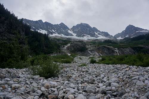
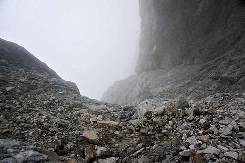
![Looking up the approach]() Looking up the approach
Looking up the approachAs the Goode Glacier and northeast buttress came into view, I saw the climbers' trail leading toward the creek, and an obvious rocky chute through the brush on the other side. The clouds had started to descend on peaks to the west, but Goode was still visible almost to the summit. After more time wasted psyching myself up, I shoved my pant-legs and socks in my pack, found a stick for balance, forded the creek, and wrung out my shoes as best I could before putting socks and legs back on for the climb.
Beckey spends more time describing this portion of the approach than the route itself, but the path of least resistance worked, climbing the stable boulder-field, then 3rd-class slabs, then more slabs, boulders, and heath next to a glacial stream. It started to rain along the way, and I stopped under the final trees for awhile to see which way the weather would go. Since it appeared to be getting no worse, I continued up the final slabs to find a way through the small glacier's terminal ice-cliffs.
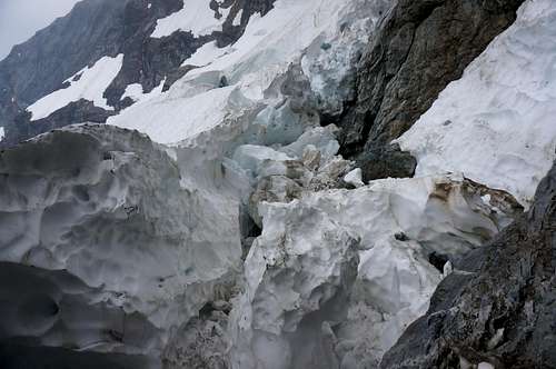
![Tricky schrund]() Tricky schrund
Tricky schrundBeckey mentions a trough directly below the buttress, but I found easier slabs and a smooth slope to the left. Though I had my crampons, I managed to get by with my ice axe and some careful step-kicking. The toe of the buttress seemed to have a nasty bergschrund and some steep, smooth pitches, so I headed for a lower-angle spur higher on its left side. The schrund here was also somewhat unfriendly, but I found my way down onto the jumble of huge snowballs filling one part, then up the other side to some steep rock. This initial, awkwardly left-slanted section had some of the trickiest climbing of the day. Fortunately the rock was solid, and Beckey's description of it as "having jointing favorable for holds" meant what I thought it did -- lots of sharp edges and jugs -- so wetness did not substantially increase the difficulty.
![Looking down buttress]() Looking down buttress
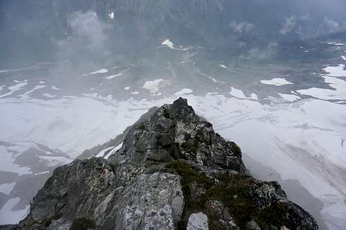
Looking down buttressOnce on the main buttress, I cruised up some easy turf to the left, then hugged the crest as it steepened and I entered the clouds. The climbing was mostly class 3-4 as advertised; while some slabby and/or lichen-y sections had to be avoided or treated with care, the wetness mostly did not cause problems. After a lot of blind climbing along or near the crest, I topped out on a pinnacle just east of the summit. A few minutes later, I was standing in one of the several bivy spots people have built on top.
I grabbed the register, found a sheltered spot, and waited around for about 10 minutes hoping to see something more than 100 yards away. I got a few glimpses of a pinnacle I thought might be the west summit, then made my way blindly down a gully to its left, hoping to emerge below the clouds above the col with Storm King.
![This won't end well...]() This won't end well...
This won't end well...A blind descent down steep, branching gullies is never easy, and I went in increasing fear of cliffing out. As the terrain steepened, I began to see old slings, and was more gladdened by signs of fellow humans than annoyed by the trash. Just before my current gully cliffed out, I followed a choss-ledge right to a steeper but passable one. Downward progress was slow, as I scrambled out onto a fin, peered as far down as I could through the clouds, then carefully downclimbed wet class 3-4 rock. Trying to save a bit of time by sliding down a snowpatch, I got a scare when I could only slow myself with my axe until I slipped off and wedged between the snow and gully wall.
I finally reached a broad, lower-angle snowfield, and headed right to its margin, where I found an oddly-placed moraine. Hoping this was near the Storm King col, I headed through a gap in the moraine and down another snowfield, expecting to arrive at the head of a glacier. Instead, I eventually found myself faced with a mixture of heath, trees, or mossy cliffs. Slightly concerned, I descended progressively worse terrain: heath, game-trails in open forest, denser forest, and steep dirt. Tiring of lowering myself hand-over hand down brush on the edge of the dirt, I made my way to a steep creek-bed, where the creek kept the plants at bay and slightly stabilized the talus.
I was not sure where I was, but I was still making downward progress, and hoped to correct my mistake when I emerged below the clouds. As it turns out, the clouds extended nearly to the valley bottom, where I saw the stream traveling in the opposite direction from what I expected. A brief thinning in the clouds around 3:40 PM gave me a rough idea of west, and I realized that I was turned around, and was in fact on the north side of an east-going valley.
Since all of the major valleys have trails in this area, I resolved to descend the valley until I reached a major trail, then either return to Bridge Creek or some other trailhead along SR 20. To my delight, I found a large cairn and a subsidiary trail just above the valley floor, and started jogging down it toward its inevitable junction with a main artery. On the long descent, I figured out my mistake: I had mistaken a buttress on Goode's south face for the Goode-Storm King ridge, and descended to Park Creek to its south. This meant that I could return via a slightly longer route down Park Creek to the old Stehekin road, then a few miles to its junction with the Bridge Creek trail.
Thoroughly soaked by drizzle that had become actual rain, I reached the road and a sign confirming my hypothesis, talked with a couple camped there, then headed down the road at a slow jog, facing what I thought was 20 miles (probably more like 13-15) on my two remaining packs of pop-tarts. The berries were ripe at this elevation, so I did a bit of foraging. The bears were doing the same: I saw three bears along lower Bridge Creek, who politely scrambled out of the way when I yelled at them, then returned to task, the first impressively going to town on a stump in search of grubs.
The climb up above the lower box canyon was a grind, but I felt my energy return on the flatter sections past the North Fork junction I had taken in the morning. My knees were sore, my legs were dead, and I was not going to produce a respectable FKT, but I felt the old compulsion to run, jogging the easier parts of the return to reach the car just after 8:00 PM.