
|
|
Mountain/Rock |
|---|---|
|
|
33.41369°N / 111.36661°W |
|
|
Pinal |
|
|
Hiking, Scrambling |
|
|
Spring, Fall, Winter |
|
|
4180 ft / 1274 m |
|
|
Overview
In the Superstition Mountains, many people have heard of Fremont Saddle. Fremont Saddle gets many visitors, especially in the cooler weather months. However, few have heard of Fremont Peak, which rises above the pass among various pinnacle rocks.
Fremont Peak really isn’t too far away from Fremont Saddle. It’s less than half a mile via the shortest route, which is marked with cairns. However, it sits in relative obscurity, with few visitors.
Fremont Peak has a prominence of about 550’. From the summit, views are tremendous. Weavers Needle sits to the north, with the Superstition Ridgeline in view to the west. You can view mountains very far away.
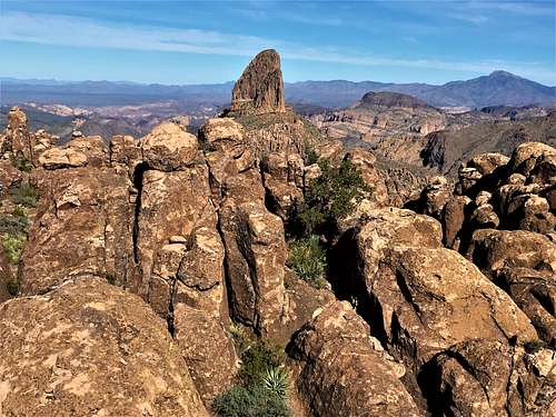 View from the summit to Weavers Needle
The primary trailhead is Peralta, which is at the terminus of a dirt road accessed from Highway 60. Fremont Peak is best hiked between November and March.
Avoid hiking above 70 degrees which is snake weather, since the final stretch of the hike is off-trail. Since the summit is higher up, you are most likely fine if it is 75 degrees in the valley.
Getting There
The hike-in begins at the Peralta trailhead off of Highway 60. Peralta Road is about 40 miles east of downtown Phoenix. It starts off paved for the first mile and then turns to a good dirt road for another 6 miles, ending at the Peralta Trailhead. If the trailhead is full, you can park a quarter mile further down the road.
Route
From the Peralta Trailhead, it is about 2 ¼ miles to the Fremont Saddle via a straight-forward trail.
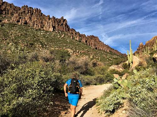 Pinnacles above the trail to Fremont Saddle
From the Fremont Saddle the route to Fremont Peak isn’t well marked. However, we left an extra cairn right before the path leaves the open area to help guide hikers.
Hiking to the summit can be done as a loop, but it is way more complicated than just taking the cairns directly up. This page will describe the shortest route. About 50 yards north along the trail past Fremont Saddle, look for some cairns that lead up into the hillside above. Take a light use trail up into an open area. Follow cairns heading straight up the slope. After about 130’ or so above the open area, a light trail heads to the right and enters the gully. Follow cairns up to the ridgetop. It’s steep, but manageable. Once at the ridgetop, Fremont Peak is about 200 yards to the left. Use your best judgement in scouting out the best route. It isn’t too complicated.
Once at the summit, it appears there are neighboring rocks to the north that appear just as high. However, as those are approached, they appear to be slightly lower. The summit located at the coordinates above seems to be the recognized summit.
If using this route, it is less than half a mile from leaving Fremont Saddle to reaching Fremont Peak. It’s less than 2 ¾ miles to the summit from the trailhead, gaining about 1,800’. Once down from Fremont Peak, there are plenty of opportunities to add hiking distance. A popular option is to hike the half mile up to the overlook on the hill with one tree, which offers a stunning view less than a mile from Weavers Needle.
Red Tape
The Peralta Trailhead is quite popular and can fill up fast. Fortunately, there is parking a quarter mile down the road, in case the parking lot is filled. There is no fee for day hiking. However, forest rangers do police the area, particularly on busy weekends during cooler months. Group sizes in excess of 15 people are prohibited. Group leaders must sign in their group at the trailhead.
External Links
Mtns are calling page by Christopher Czaplicki