
|
|
Mountain/Rock |
|---|---|
|
|
47.42559°N / 11.77447°E |
|
|
Hiking, Mountaineering |
|
|
Spring, Summer, Fall |
|
|
6421 ft / 1957 m |
|
|
Overview
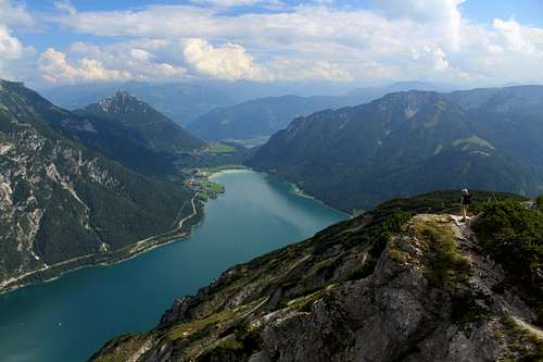
The Ebner Joch is part of the Brandenberger Alpen group of mountains. It lies on the south side of the Rofan massif and overlooks the Inn valley to the south and the town of Maurach and the southern end of the Achensee, to the north west. The pass between the Karwendel and Brandenberger mountains where Maurach lies, is an ancient route running northwards from the Inn valley. Archaeologists have found evidence from human artefacts going back nearly 8000 years and the Ebner Joch remains as a signpost to guide travellers through the mountain terrain.
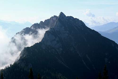
The Ebner Joch looks a formidable mountain from most angles. It rises steeply through a dense covering of trees, broken only by man made forestry tracks and paths, to a dramatic and craggy limestone crown. The first impression of it is that summiting this peak must involve rock climbing or at least scrambling to succeed. However, the reality is that it is more of a “Sheep in Wolf’s clothing” in that the most difficult parts are the loose, rocky paths that have to be traversed to gain the top. There is no climbing or scrambling.
Getting There
By car from Munich:
A – 140km.
Head south on the A8 towards Salzburg.
At the 101 Dreieck Inntal junction, head south towards Innsbruck on the A93.
This road becomes the A12 as you cross the border into Austria.
At junction 39 (Wiesing), head north towards Wiesing and Achensee on the B181.
You will arrive firstly at Eben, then Maurach.
Or
B – 103 km.
Head south on the A8 towards Salzburg.
At exit 97, head southwards towards Holzkirchen and Tegernsee and continue on the B318.
At Tegernsee, follow the B318 to the right around the west side of the lake.
Turn right onto the B307 which becomes the B181 as you cross the border into Austria.
Follow this road until you approach the Achensee from the north, arriving first at Maurach, then Eben.
(As you can see, route A is longer than route B but is often quicker!)
By car from Salzburg
Head West on the A8.
At the 101 Dreieck Inntal junction, head south towards Innsbruck on the A93 and follow route A above.
By car from Innsbruck
Head East on the A12 towards Salzburg
At junction 39 (Wiesing), head north towards Wiesing and Achensee on the B181 and follow route A above.
By public transportation
Innsbruck – Jenbach by train, then Bus to Maurach
Salzburg – Jenbach by train, then Bus to Maurach
Munich – Salzburg or Innsbruck, then follow as above.
Routes
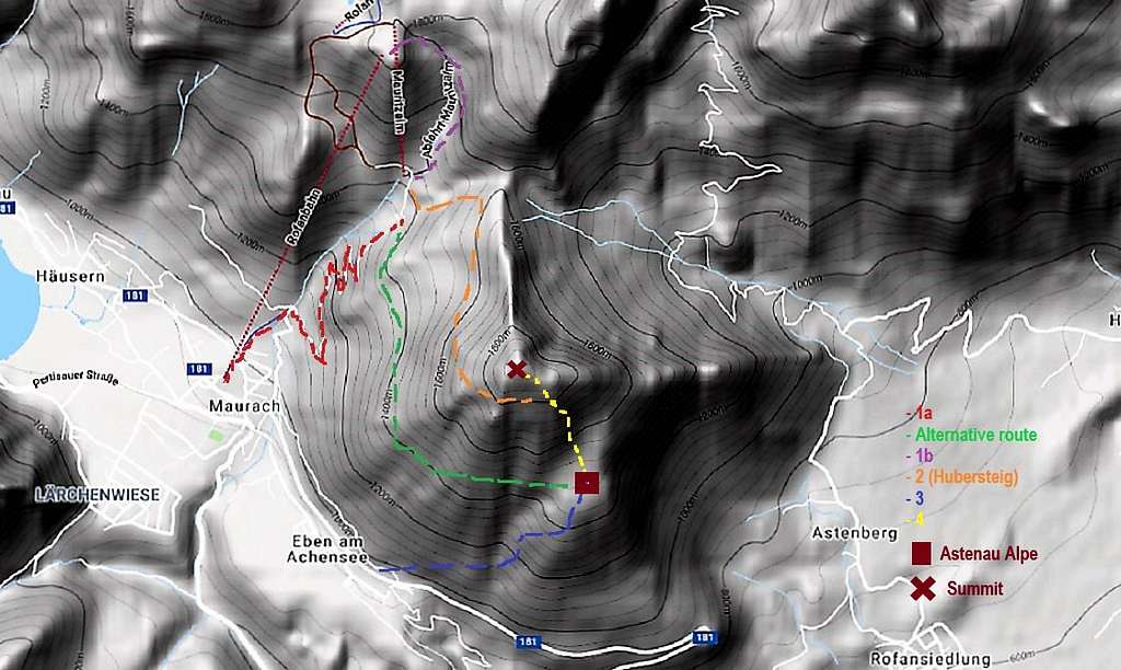
From Maurach
1a – Walk from Rofanseilbahn car park, Maurach to the “Hubersteig”.
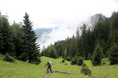
From the car park, take the sign posted road and path uphill until the bridge is crossed. Continue to the right on the forestry track uphill. The track zigs and zags upwards around 5 bends until the tree cover opens up at the Buchauer alm. (From the bridge, it is also possible to take a more direct but steeper path to the Buchauer alm.)
(Alternative route - The forestry track continues to the right, contouring around the mountainside until, after a viewpoint, it continues as a path to the Astenau Alpe. Continue from here as per the instructions shown below, no 4 route from the Astenau Alpe to the summit).
From the Buchauer alm, continue upwards following the sign for “Rasthutte Mauritz” until the junction with path no 12 on the map, the “Hubersteig”.
Continue from here as per the instructions shown below, no 2 route from the “Hubersteig” to the junction with the path from the Astenau Alpe.
1b – Get Rofanseilbahn up and descend to the “Hubersteig”.
Catch the Rofanseilbahn from Maurach. From the top of the Rofanseilbahn, follow the track (signposted as no 401) downwards. The time from here to the summit of the Ebner Joch is shown as 2 ½ hours.
At first, the path descends an on open hillside and then through some light tree cover to the junction with the “Hubersteig”
Continue from here as per the instructions shown below, no 2 route from the “Hubersteig” to the junction with the path from the Astenau Alpe.
2 - From the “Hubersteig” to the junction with the path from the Astenau Alpe.
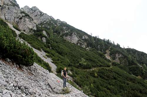
Head upwards across some open hillside, then deeper forest. The marked path winds through the tall trees before these gradually lose their stature and become the stunted, stubby pines that are common in this area. As the route continues, it crosses scree filled slopes and the occasional rocky step without ever really becoming a “scramble”. Every now and then you catch a glimpse of the summit cross above you, gradually getting nearer!
Eventually, you climb a rise in the path to a well-positioned bench. From here, the route moves towards the southside of the mountain underneath some avalanche protection constructs and joins the route rising upwards from the Astenau Alpe.
Continue from here as per the instructions shown below, no 4 route from From Astenau Alpe to the summit.
 |  |
From Eben
3 - From Eben to the Astenau Alpe.
From the railway station at Eben, cross the main road and follow path no 10 through trees and upwards towards the “Astenau Alpe” hut. The path is at an easy angle at first but steepens as it gets nearer to your goal. The hut is built in a good position to offer views over the inn valley.
(The Alternative route shown above reaches the Astenau Alpe at this point).
4 – From Astenau Alpe to the summit.
A rough path heads steeply upwards through the trees towards the Ebner Joch summit.
(The route shown above as no 2 - From the “Hubersteig” to the junction with the path from the Astenau Alpe, joins from your left-hand side.)
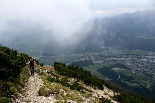
The path wends its way through more low growing trees then the slope opens up onto more rocky slopes. The views southwards across the Inn valley are expansive on a clear day.
Suddenly, the summit cross is just ahead and soon the summit is reached. The last part of the ascent is easier than perhaps would have been imagined and occupies a larger area than expected.
Descend by any combination of the routes at your leisure.
Red Tape
No red tape
When to Climb

Spring, Summer and Fall.
Winter ascents would also be possible but the snow conditions and need for winter equipment could differ from one day to the next.
Camping
http://www.karwendel-camping.at/
http://www.achensee-camping.at/
Maurach and Pertisau are popular holiday destinations and have many Hotels and Pensions.
Map
Mayr Wanderkarten – No 429/1 and 429/2 Achensee.
External Links
https://www.achensee.com/en/towns/maurach-am-achensee/