
-
 3873 Hits
-
 71.06% Score
-
 1 Votes
|
|
Route |
|---|---|
|
|
39.67980°N / 106.2581°W |
|
|
Mountaineering |
|
|
Summer, Fall |
|
|
Most of a day |
|
|
III-V (Depending on route selection) |
|
|
Overview
Getting There
From the Bighorn Creek Trailhead hike up the Bighorn Creek Trail for approximately three miles to the small cabin in the meadow. The official trail ends here, but a well-worn climbers trail continues up the valley on its left side. The trail ends close to a meadow with several ponds.Continue along the Bighorn Creek until its source at the end of the Bighorn Valley in a basin full of talus, surrounded by ridges on three sides.IMPORTANT: Big Horn Trailhead allows on most parking spots only parking for 3 hrs, only a couple allow parking from 7 am to 11 pm. NO OVERNIGHT PARKING is allowed. Public parking space at the Interstate Exit 180 also does not allow overnight parking
![Saddle between East Ridge and Climbers Point]()
![Southeast and East Ridge]()
![Southeast Ridge]()
![MAP]()
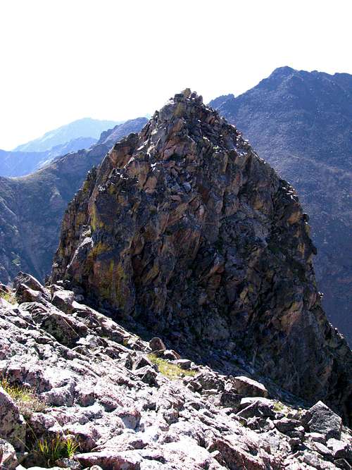
![End of East Ridge]() When standing in the basin:
To your left (West)rises the Southeast ridge - straight ahead is the easier East Ridge (probably class 2+).
Easily gain the Southeast Ridge and climb on/along the crest over four gendarmes.
You can keep difficulties to class 3 - however, the gendarmes offer also class 4 routes.
The gendarmes are followed by a hike up grassy slopes and an easy scramble along the ridge to the peak you see right above you. It marks the meeting point of East and Southeast Ridge - Climber's Point looms in quite a distant to the west.
After gaining this point on the ridge you will have spectacular views of the Northern Gore ranges and the rarely visited Boulder Creek Valley right below you.
Scramble (class 2) along the crest in direction of Climber's Point, with vertical dropp offs to your right.
The East Ridge becomes increasingly narrower the closer you get to Climber's Point. The last part of the ridge requires an airy class 3+ climb on a narrow jackknife with dropp offs on both sides.
The jackknife is the crux of the whole climb.It ends in a vertical cliff as the East Ridge is separated from Climber's Point by a deep saddle.
Two main options to get down to this saddle:
1. rapel down an almost vertical gully at the end of the jackknife
2. when climbing on the jackknife, look to your left - you will see a ravine leading all the way down to the talus field in the basin below Climber's Point - climb down the ravine and climb up the talus field to gain the saddle below the summit block. This is a very tedious option - lots of altitude loss which has to be regained. The ravine can also serve as an emergency exit route - Bighorn Valley is right below the talus field.
Very confident climbers might be able to find a route over to the saddle through the cliffs on both sides of the jackknife. This involves very exposed class 4/5 climbing. The right side of the ridge (north) is an almost vertical cliff - if you slip not much will stop you from falling 300 feet down to the talus fields of Boulder Creek Valley.
After gaining the saddle, a talus loaden slope will get you up to Climbers Point (scouted from East Ridge - dark clouds moving in ended my trip after climbing down the ravine).
When standing in the basin:
To your left (West)rises the Southeast ridge - straight ahead is the easier East Ridge (probably class 2+).
Easily gain the Southeast Ridge and climb on/along the crest over four gendarmes.
You can keep difficulties to class 3 - however, the gendarmes offer also class 4 routes.
The gendarmes are followed by a hike up grassy slopes and an easy scramble along the ridge to the peak you see right above you. It marks the meeting point of East and Southeast Ridge - Climber's Point looms in quite a distant to the west.
After gaining this point on the ridge you will have spectacular views of the Northern Gore ranges and the rarely visited Boulder Creek Valley right below you.
Scramble (class 2) along the crest in direction of Climber's Point, with vertical dropp offs to your right.
The East Ridge becomes increasingly narrower the closer you get to Climber's Point. The last part of the ridge requires an airy class 3+ climb on a narrow jackknife with dropp offs on both sides.
The jackknife is the crux of the whole climb.It ends in a vertical cliff as the East Ridge is separated from Climber's Point by a deep saddle.
Two main options to get down to this saddle:
1. rapel down an almost vertical gully at the end of the jackknife
2. when climbing on the jackknife, look to your left - you will see a ravine leading all the way down to the talus field in the basin below Climber's Point - climb down the ravine and climb up the talus field to gain the saddle below the summit block. This is a very tedious option - lots of altitude loss which has to be regained. The ravine can also serve as an emergency exit route - Bighorn Valley is right below the talus field.
Very confident climbers might be able to find a route over to the saddle through the cliffs on both sides of the jackknife. This involves very exposed class 4/5 climbing. The right side of the ridge (north) is an almost vertical cliff - if you slip not much will stop you from falling 300 feet down to the talus fields of Boulder Creek Valley.
After gaining the saddle, a talus loaden slope will get you up to Climbers Point (scouted from East Ridge - dark clouds moving in ended my trip after climbing down the ravine).
Route Description


