
-
 7371 Hits
-
 81.18% Score
-
 13 Votes
|
|
Route |
|---|---|
|
|
48.57868°N / 120.87473°W |
|
|
Hiking, Mountaineering, Scrambling |
|
|
Spring, Summer, Fall |
|
|
Most of a day |
|
|
Class 4 |
|
|
Overview
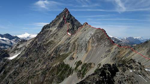
The east ridge of Mesahchie Peak is a spectacular way to do this mountain if you either are not planning to do the remaining peaks of Ragged Ridge (Katsuk Peak, Kimtah Peak and Cosho Peak) or if you have already done them. It is a fun, wild and remote route offering some sustained Class 4 scrambling with plenty of exposure. The route can be done in a fairly long day or you can make it a two day outing with camping opportunities in a few select areas described below. This route has a net elevation gain of 5,100 feet from trailhead to the summit, however there are numerous ups and downs along the ridge, with the biggest being the hike over Cub Peak. This brings the total gain to about 5,900 feet at a minimum.
Mesahchie Peak East Ridge Topo
Getting There
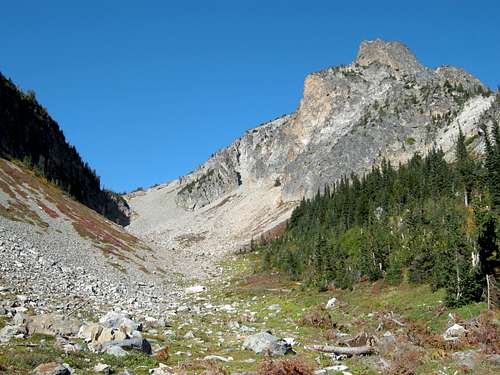
From Newhalem, which can be reached either from Highway 20 from Mount Vernon, or Highway 530 through Darrington, continue east on the North Cascades Highway (aka Highway 20) for 32 miles. A short, signed spur road on the right leads to the Easy Pass Trailhead. Hike the excellent trail for 3.6 miles to Easy Pass which has an elevation of 6,540 feet. The trail is regularly maintained by the WTA and the switchbacks on the upper scree field are typically in decent condition.
Easy Pass and New Morning Peak
Route Description
From Easy Pass, continue west on the trail until you first get a glimpse of Mount Logan across the Fisher Creek Valley. From this viewpoint, leave the trail and hike up steep grassy slopes to the northwest for 760 feet until you reach the top of a small 7,300 foot knob on the ridge. From this knob you can see a steep cliff immediately to the west. You will have to descend about 100 feet to the left side, and traverse at the 7,200 foot contour until you can begin ascending. It is recommended you ascend to the 7,500 foot contour and continue traversing all the way to the 7,450 foot saddle just south of Kitling Peak. You could also ascend back to the crest at or near Point 7,690 and descend to this saddle along the ridge. This broad saddle is just under a mile from Easy Pass.
 Hiking on the east ridge |  Traversing below Kitling Peak |  Kitling Peak from Cub Peak |
Instead of hiking up and over Kitling Peak, traverse at 7,400 feet along its south side staying just below the crags leading up to the upper part of the peak. Reach another saddle at 7,460 feet, then scramble up to the 7,960 foot Cub Peak, which involves a 500 foot ascent some of which is Class 3. From the top of this subsidiary peak, the remainder of the route to Mesahchie Peak is clear. Descend 300 feet to another saddle and scramble around some big boulders until you reach the base of the steep headwall. Do not scramble directly up but instead descend slightly left and around a rib, and enter an obvious gully. Climb this gully roughly 250 feet and cut left just before the gully reaches the ridge crest into another, smaller gully with a steep Class 4 chimney at the top. You will find some rap slings and a cairn at the top of this spot. Continue up a second gully until you reach the crest, and traverse left across a large slab to the base of the final scramble.
 Mesahchie Peak from Cub Peak  Josh scrambling the upper east ridge |  Looking up the first gully  Josh scrambling to the big slab |  Summit block of Mesahchie Peak  Scrambling a ledge below the summit |
The final scramble is the most exposed on the route, and involves climbing to a false summit, and traversing its right (north) side just below it. Once past that, it's another 15 minutes of scrambling on the very exposed summit ridge to the highest point (Class 3-4). Avoid difficulties on the north side of the ridge.
 Bypassing the false summit |  Looking back at the false summit |  Fisher Creek Valley near Easy Pass |
Essential Gear
In summer, just the normal day hiking gear is needed, along with shoes you are comfortable scrambling Class 4 in. Early season ascents will require an ice axe, and likely crampons and possibly a rope/harnesses/pro. There is no water on this route past Easy Pass, unless remnant snowfields persist. Either carry enough water for a long day or plan to use snow.
Map
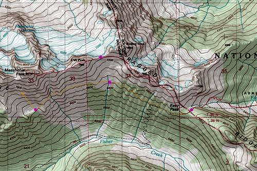
Mesahchie Peak Route Map