

-
 1967 Hits
-
 75.81% Score
-
 6 Votes
|
|
Route |
|---|---|
|
|
45.31940°N / 116.5319°W |
|
|
Mountaineering |
|
|
Spring, Summer, Fall |
|
|
Most of a day |
|
|
Class 3 |
|
|
I |
|
|
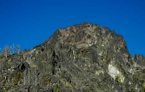
The upper part of the East Ridge
Overview

View up ridge from trail
The long east ridge of the The Goblin is quite distinct up to about the last five to six hundred feet where it broadens out into a jumbled face comprised of large blocks, ramps and ledges. There are various ways to find your way up this last part by connecting ramps and ledges to reach the final crest. The ramps and ledges are Class 2, but are connected by short steps of Class 3 or harder depending on the exact route taken. We climbed one step distinctly harder than Class 3, but more of a bouldering move since it was only about 8 to10 feet high.
Getting There

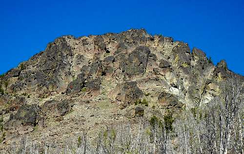
Telephoto of E Ridge from N
About 1 mile south of Riggins, turn right onto Seven Devils Road. It is about 17 miles to the trail head at Windy Saddle. The first part of the road is paved, then it becomes steep and winding gravel but is passable by passenger cars.
The easiest access to the ridge is to follow the main trail south from Windy Saddle to where it crosses the ridge crest just beyond Cannon Creek. The lower part of the ridge has a lot of dead fall and a bit of brush, but overall it is not difficult travel. The ridge can also be accessed via numerous talus filled couloirs on its north side from the area of the lower Cannon Lake. These are steep, loose, and not recommended. See Photo & caption
From Windy Saddle to where the trail crosses the ridge crest, it is about 3.4 miles involving an initial 1,000 foot descent followed by some ups and downs on the trail. Our Map Tracker program shows: 3.4 miles, descending 1,585 feet, climbing 545 feet, and a total elevation difference of minus 1,040 feet. The unpleasant part of the trip is climbing the 1,000 feet back up to Windy Saddle at the end of the day.
From where the trail crosses the ridge crest to the summit is about 1.5 miles with an elevation gain of about 2,385 feet.
Route Description
Follow the ridge along its crest with detours to the south side to bypass cliffs. At about 500 feet below the summit, the distinct ridge crest ends in a broad jumbled “face”. There are several possibilities for how to connect various ledges and steep ramps in the climb to the upper ridge. The ramps and ledges are Class 2 – some loose talus and some with a bit of vegetation. They are connected by short steep sections of Class 3 or harder scrambling. With patience and a willingness to back track a little, you should be able to find a way no harder than Class 3. The way we went involved one short (8 to 10 foot) section that was harder than Class 3, but with no dangerous exposure –more of a short bouldering move.
You will probably top out on the final summit ridge to the northeast of the top. Follow the crest – Class 3 – to the summit.
The upper part of the East Ridge of The Goblin where is quits being a distinct ridge and is more of a jumbled "face" with large blocks, ledges and steep ramps. We started the climb of this section up a steep ramp just left of the dark colored block with the red dot. Enlarge for better detail.
On the Route
 Very low Very low |  Class 3 Step Class 3 Step |  Summit ridge Summit ridge |