-
 6319 Hits
-
 75.81% Score
-
 6 Votes
|
|
Route |
|---|---|
|
|
52.14910°N / 117.43711°W |
|
|
Download GPX » View Route on Map |
|
|
Mountaineering, Skiing |
|
|
Summer |
|
|
A few days |
|
|
PD |
|
|
Overview
Mount Columbia is a ski-mountaineering destination. It is rarely climbed in the summer, but doing so is nonetheless a unique glacier experience on the vast icefield. The route is the same as in the spring, but difficulties differ.
Choosing the Approach
I was part of a custodial group expedition in August 2018. Finding no guide with summer icefield experience, we took the longer Saskatchewan glacier approach, not keen on passing under the Snow Dome seracs in unknown conditions as a large group.
The expedition failed for unrelated reasons, so I returned with a friend in August 2019. Upon visual inspection from the highway, we found the route on the shorter Athabasca glacier approach far enough in the runout zone below Snow Dome and the ramp continuous enough to attempt it.
Saskatchewan Glacier Approach


Park in an unsigned lot near the Big Bend on the Icefield Parkway (52°10.352’N, 117°3.858’W). Cross the bridge, walk 1 km upstream and follow a trail into the woods.
After the vegetation opens up, you will want to cross to climber right of the river. Where the river enters a canyon (52°9.923’N, 117°5.085’W), a log jam is the best option if still present. Not knowing that, we saw ourselves too high, backtracked, and had to wait for a morning calf-deep crossing at 52°09.881’N 117°06.702'W; there may be better spots lower. Gain the Saskatchewan glacier and then the icefield.
Athabasca Glacier Approach


Park at the Athabasca glacier toe, walk up the tourist trail, and enter a path to the glacier at a “Do not enter, guided group only” sign. Reach for and follow the SnoCoach road, while being photographed by tourists and encouraged by drivers (feels heroic!).

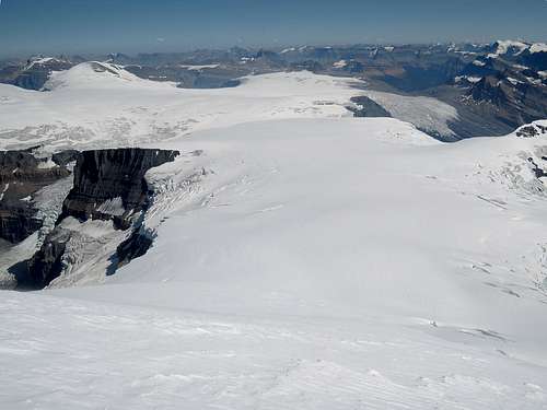
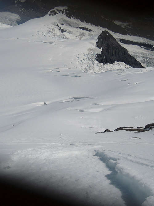
Aim to climber right of the glacier to exit at the bottom of the first icefall. Pass the first icefall around on the rock glacier and the second through a short 45° rock or snow. Go around open crevasses and cross the runout zone of Snow Dome seracs.
Find a way to the bottom of the ramp in the third icefall then head straight up. Navigate around many poorly covered transverse crevasses in the convexity above.
Route Description


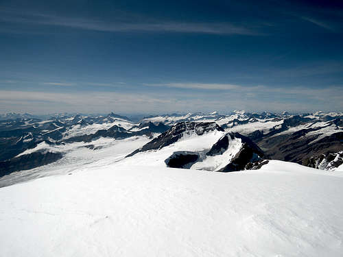
Once on the icefield, beeline to a low saddle halfway into the icefield, the Trench; GPS and compass useful. Slightly sheltered, probe around if camping there as there are crevasses. Beeline again to the south edge of the east face.


The face is a fairly sustained 45°, steepest in the middle near the rock band, which can offer some respite if postholing. Short wind-scoured ridge to summit. On the descent, snow on the face was getting waist-deep for us, which forced glissading. It returned to at most ankle-deep once on the flat.
Objective Hazards
The face, being east-facing, tends to get wind-loaded, and its snow softens quickly. Our guides in 2018 did not fret about avalanches, yet with the stars aligned in 2019 (snow and rain 2 days before, bluebird afternoon), I made a small slab slide.
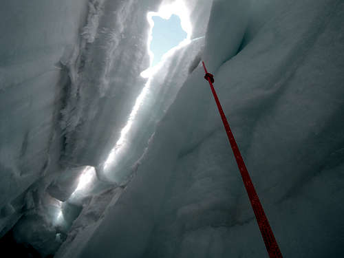
We were unable to visually retrace our steps through the Sun-baked icefield, so we backtracked with the GPS in the crevassed area above the ramp. With no deep freeze there and a second sunny day, I got personal with one…
At least we never witnessed any ice fall from Snow Dome seracs.
Strongly consider alpine starts. Too many close calls for us.
Miscellaneous Information
On mid-August weekdays, we found the Icefield and Wilcox campgrounds to be full around 6 pm, the former being quieter and less cramped. The RV park was fairly empty.
Cell phone service was introduced at the Icefield Center in 2019, reaching the entrance of Wilcox and at least partway up the Athabasca Glacier.
Call the park office in Jasper for the bivouac camping permit. Though reading “Icefield random”, it still said that bikes are not allowed but we may encounter horses!
Essential Gear
Typical glacier travel and camping gear.
GPS and compass.
Avalanche gear probably not, depending on conditions.
The glacier equilibrium line was at the bottom of the ramp in mid-August 2019. Skiing may still be the faster travel mode in the summer, and may reduce the crevasse fall risk.