Prominence, a new way to measure a mountain - some background
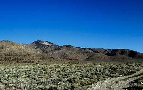
![Dutch Mountain]() Heading for Spotted Fawn Canyon on the east side
Heading for Spotted Fawn Canyon on the east side
My 94th? What do I mean by that? Well, to make it as simple as I can, it was my 94th summit of the top 100 prominence peaks in the state of Utah.
There are all kinds of reasons why some of us like to climb (or hike) a mountain and these reasons could be:
It is beautiful
It is high in elevation
It is close to my home
It is great for fitness conditioning
It is on your bucket list
It is has a lot of prominence
Most of the reasons above make sense, all but the one that is about prominence.
Prominence? What in the world is that?
"The technical definition of "Mountain Prominence" is that it is the vertical distance between a peak and the lowest contour line surrounding that peak and no higher peak."
Did you follow that? Its ok if you didn't, it took me awhile to get my brain wrapped around the concept of prominence. But once I did, I haven't looked back. It has been very addictive. Chasing the prominence peaks of a state will result in your visiting almost every corner of that state and driving just about every road and highway including dirt roads and jeep tracks. You will come to realize that each state is tremendously diverse and how truly isolated and hard to get to many of them are. Often times you won't find a trail and visitation may be one or two parties a year. Unfortunately, some prominence peaks are also attractive to the communications world and so many are marred with communication structures of all sorts and often a road has been built to the very summit to provide access. Lookouts are often found on the top of a promimence peak and have had roads built as well. These peaks are much more visited and on a good weather weekend, you may meet others who want to see the world from the top of that particular mountain. At least, these intrusions by man are in the minority but I can promise you that the views from the top of a prominence peak are often the absolute best you can get unless you are in an airplane. Check out this
list of john table for current leaders in three categories of continental (conus) peakbagging. The ultra list, the 2000' of prominence list and the 1000' of prominence list. I'll explain what these are about below.
Using Utah as an example for a state with prominence peaks.
Utah has 81 of these mountains that have over 2000 feet of prominence and of these 81, 8 of them have over 5000' of it. The ones with over 5000' feet are called Ultras and there are but 57 peaks with this distinction in the lower 48. The two most popular peaks in the state for visitation are Kings Peak (the state highpoint) and Mount Timpanogos, a giant that stands above the metropolitan area of Provo, Orem and other Utah valley cities but has two good trails that go to the summit. Utah also has 360 mountains that have more than 1000' of prominence (this includes the 81 mentioned before) and these are scattered all over the state.
Now for the reason for writing this trip report now that perhaps you have a bit more understanding of what a prominence peak is. The List of John website
created a list of the top 100 Utah prominence peaks and that is one of the lists that caught my attention and one I have been actively working on for the past several years. The list has all 81 of the peaks with 2000' of prominence and includes another 19 that didn't quite reach the 2000' mark.
Still, each of the 19 are worthwhile and have been fun to do. One of the nice things about Utah prominence peak bagging is that most of the peaks on the list don't have access problems. A few that do require getting permission from the land owners but they are fortunately very few. Messix and Lewis peaks require permission but most of the peaks are on BLM land, national forest or national park land.
If you go to Lists of John and check out
the "prominence member area" section, you'll now find my name listed as the top completer. Of course, I'm really in second position because a good friend of mine, Greg Jagielski doesn't list his peaks there. He has 97 of the top 100 and I know for a surety that he has been on top of those mountains. The three he has that I don't are Mount Marvine, Wagon Ridge Road HP, and Porcupine Mountain. He is truly an amazing hiker/climber and can run like the wind as well, having completed a 50 mile and 100 mile ultra race last year alone. Of course, this trip report wasn't written to talk only about Greg but it is only fair that he get credit for being the true number one of the top 100 list. He would also be the leader on the list that shows leaders in the 1000' prominence category but I could only guess on what that number would be. Probably over 200 at the present time.
For me,number 94 was a long time coming since I haven't done much hiking/climbing in Utah the past couple of years as I have been spending most of my spare time making trips out of state to get prominence peaks that have over 2000 feet of prominence in
Nevada (125 of 169),
Arizona (37 of 73) and
Idaho (43 of 98),
Oregon (67 of 74). I also have a lot done in Washington, California and Wyoming but they will require a lot more effort and I'll keep after those states but I decided that this year would be a good one to start working on finishing this list for the Utah top 100.
One note would be that getting all 100 is out of the question since Granite Peak on the Dugway Proving ground is totally off limits and inaccessible to non military folks.
The trip report
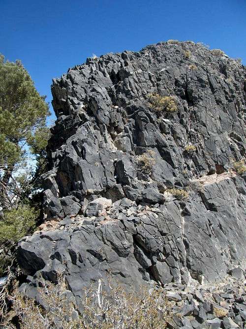
![Near the summit]() Cliff section
Cliff section
My wife came up with the key question on Monday afternoon when she asked "Don't you have a mountain over by Wendover that you need?"
I answered in the affirmative and soon we were making plans to head over to Wendover, Tuesday evening where we could grab a motel room and be climbing Dutch Mountain early the next morning. The weather was ideal and it looked like a great time to do this one. With my wife on board for the trip, we did some simple packing and were ready to go Tuesday afternoon. I also contemplated picking up a 1000' foot prominence peak while we were out there but my main goal was to get Dutch Mountain, one of the top 100 prominence peaks in Utah. As mentioned in the first section, it would become the 94th completion on the top 100 list and I was anxious to go get the job done.
Wendover is about a two hour drive and we pulled into Wendover about 7 p.m. monday evening and found a room at the Montego Bay for a fairly reasonable price. We found a decent meal there and went to bed early enough so I could get a good morning start.
At 7:15 the next morning, we were headed south on highway 93 alt, stopping once for me to take a picture of Goshute Mountain that had a nice coat of snow on it. After about 25 miles, I turned onto the paved road that leads toward Gold Hill and the Goshute Indian reservation. After 14 miles on this road, the turnoff for Gold Hill made its appearance and we turned off of the paved road onto a road that was basically dirt and gravel. The ghost town of Gold Hill was 11 miles up that road but from the turn off we had a good look at Dutch Mountain and there appeared to be a layer of snow on the upper reaches (northwest side). That didn't bother me too much even though my wife expressed some concern as we would be approaching it from the east and up Spotted Fawn canyon. If we didn't hit snow on the 4 WD road, we might be able to drive all the way up to the Silver Hill mine, located at the 6400 foot level.
We hit the right road connections and soon found our way near a herd of sheep that had just been shorn and were in pens waiting to be moved. The road became rougher and we followed it as it led us up into Spotted Fawn Canyon. A few rough spots had my wife thinking we should park and walk from there but the road was decent enough to let us get to the very end of it and we found no stoppers along the way. Parked at the mine area, I left my wife with a walkie talkie and started finding a route up the steepening slopes toward a waypoint that I had made for the summit location. It turned out to be a good move on my part as normally I would have been inclined to head for a saddle along the ridgeline but in this case, it worked out well as I found my way up through grassy slopes, then scree, then snow covered scree with patches of mud to be avoided along the way. As I neared the top, I had to negotiate my way through some small cliffy bands, none of whom were more than a low class 3 in difficulty. I had to watch my step due to wet rocks from melting snow and loose scree that covered some of the steps. Before long I found myself on the summit and staring at an old surveyors
wooden tripod that was laying on the ground a few feet away from a mound of rocks built on the highest spot.
Inside the cairn I found a register in a glass bottle placed by Greg Jagielski and Kadee Smith in 2008. A few others had signed in but not many. I found a witness benchmark along with the main central benchmark and after taking pictures of the surrounding area and of the register pages, I let my wife know via the walkie talkie that I would soon be on my way down. After carefully working my way through the cliffy spots, I found a good scree slope where I was able to drop several hundred feet of elevation rather quickly. Once at the bottom of this relatively narrow scree field, I just side stepped my way down the steep area to where it lost its steepness and made my way back to my Tacoma where my wife was waiting.
Overall, it was a great little hike that wasn't much more than a mile and a half roundtrip but was steep in some sections as it gained over 1300' in a short distance. The views from the summit were outstanding and I had now completed my 94th summit of the top 100 list.
The drive back down and then to Wendover went without incident and we treated ourselves to a nice buffet at the Rainbow Casino before making the drive back to our home in the Lehi area. Thanks to my wife for being willing to ride along with me and cheer me on via the walkie talkies that we use when our cell coverage is spotty. This is a great area and I would suggest that you don't think about doing this one during the summer, temperatures can easily go well above 100 degrees. Carry plenty of water, even though this is a short hike if you use the Silver Hill Mine route.
Pics
I have a lot of pics attached to the
Dutch Mountain / East Side route page. I will eventually get a few of them moved over to this page but please check out the pics I've attached here as well if you are at all interested in this mountain as something you'd like to do sometime.
Comments
No comments posted yet.