
-
 820 Hits
-
 76.66% Score
-
 7 Votes
|
|
Route |
|---|---|
|
|
46.33999°N / 14.41793°E |
|
|
Download GPX » View Route on Map |
|
|
Hiking |
|
|
Spring, Summer, Fall |
|
|
One to two days |
|
|
T3 (Swiss Hiking Scale) |
|
|
Overview
As said on the main page of Storžič, we can do a nice hiking tour, also skipping the highest summits of Storžič Group. Enjoying the great southern panorama and interesting vistas towards the neighbourhood, we shall visit on a 2-days tour 6 mountain/shepherds/hunters huts, a few alpine meadows and optionally as many summits we wish.
Getting There
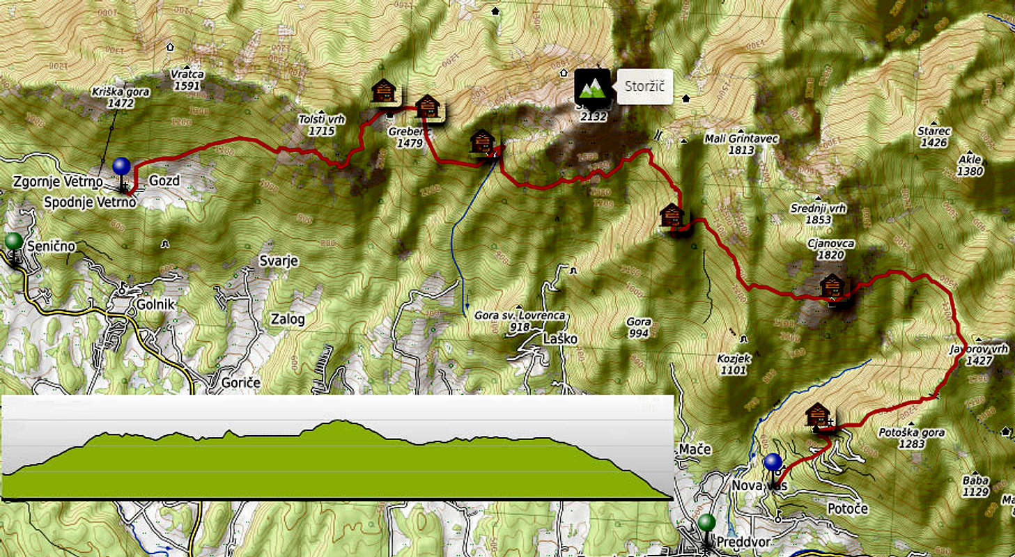
The tour can be done with the support of public transport or by arranging transport logistics with 2 cars (or more). It's equally recommendable in both directions, but here the west-east direction will be described. So, these are the details:
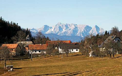
- Having 2 cars: Leave one car above Preddvor (above the Turn castle), drive with the other car to Gozd village (blue pin on the map), where you start the tour.
- Public transport: Take a bus towards Golnik/Senično/Križe and start the tour down there (green pin on the map).
General Information
Overall difficulty: It's a hiking tour. The most demanding stretches of the tour would be graded on the Swiss Hiking Scale with T3. Predominant difficulty of the trails is T2.
- Endurance: As only hiking will take you some 9 h 30 min, it's recommendable to do the tour in 2 days. But with good logistic and being fit, it's also possible to do it in one day. Overall, it's some 19.2 km of distance, some 1150 m up and some 1440 m down.
- Power: No special power in hands is needed, it's almost exclusively walking. Protection devices on a few rare stretches are only to maintain balance.
- Psyche: Absence of vertigo is required on a few sections, which can be avoided by additional 30 min climb up.
- Orientation skills: With a usual online map and this description only basic skills are needed. All the trails are marked.
Objective dangers: There are almost none.
Altitude gain: The lowest point is 890 m, the highest point is 1570 m. But there are all the time ups and downs, altogether 1150 m (1520 m) up and 1440 m (1570 m) down.
Time for the whole tour needed: In average 9 hours, 25 minutes, only for walking.
Best season: It's from late spring (when the slopes are free of snow) till late autumn (when the're still no fresh snow, nor ice). Avoid winter months when the demanding stretches are even more demanding (snow, ice, steep terrain) and when the huts are all closed.
Best day time: If on a one day tour, start it very early! For a two days tour (it's best to sleep in Dom na Kališču) you can be more comfortable.
Gear: Only the usual hiking gear is needed (don't forget poles).
Maps: Good online maps are sufficient. For the classical maps, see the page of Storžič.
Huts and bivouacs: For a 2-days tour, the advice is to reserve sleeping in Dom na Kališču (roughly mid-way point). The other huts are:
- Zavetišče v Gozdu, 897 m. Official mountaineering hut, reachable by car.
- Mala Poljana Hut, 1327 m. Hunters hut, eventually you may get there some food and drink.
- Velika Poljana Hut, 1410 m. Ex shepherd hut, now a private one. They offer food and drink in season.
- Karničar's hut on the Javornik meadow, 1380 m. Ex shepherds hut.
- Dom na Kališču, 1535 m. Big official mountaineering hut, opened also on holidays and nice weekends out of the main season.
- Zavetišče v Hudičevem borštu, 1324 m. New mountaineering hut (ex hunters hut), open during the season.
- Planinska koča Iskra, 961 m. Official mountaineering hut, opened also on holidays and nice weekends out of the main season.
Route Description
On the pages of Tolsti vrh, Storžič and Srednji vrh almost all stretches of our combined route are described in detail. So, below only shorter descriptions are presented.
Main sections:
- Villages below Gozd - Gozd village: 1 h 30 min. (Up: 365 m, Down: 0 m). T2/T1.
- START. Gozd village - Mala Poljana meadow: 2 h. (Up: 590 m, Down: 150 m). T3.
- Mala Poljana meadow - Velika Poljana meadow: 15 min. (Up: 100 m, Down: 20 m). T1.
- Velika Poljana meadow - Javornik meadow: 30 min. (Up: 30 m, Down: 60 m). T2.
- Javornik meadow - Dom na Kališču (hut): 2 h 30 min. (Up: 285 m, Down: 130 m). T2.
- Dom na Kališču (hut) - Hudičev boršt (hut): 1 h 30 min. (Up: 70 m, Down: 280 m). T2.
- Hudičev boršt (hut) - Sv. Jakob: 2 h. (Up: 75 m, Down: 440 m). T2.
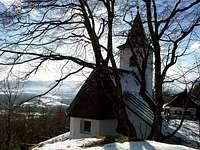
- Sv. Jakob - Grad Turn. END: 40 min. (Up: 0 m, Down: 360 m). T2.
- Grad Turn - Preddvor: 15 min. (Up: 0 m, Down: 130 m). T1.
_______________
Tour altogether: 9 h 25 min (using bus: 11 h 5 min). Altitudes: Up: 1150 m, Down: 1440 m (Or, up: 1520 m, down: 1570 m).
Turn-to-turn descriptions:
From the eastern part of Gozd village we start hiking up towards the summits of Kriška gora and Tolsti vrh. Above the village we keep right, following the cart road where the direct ascent on Tolsti vrh goes. From its highest point we deter left up, following the marked trail on Tosti vrh. We gain the bench (Saška's bench), continue some 100 m, and on the trails branching continue right - by the Štajner route. We soon reach the S ridge of Tolsti vrh, around the rocky edge there are a few exposed stretches, secured with cables. On the other side we continue to another bench and through the woods till the dirt road and down to Mala Poljana.
Extension: We can climb Tolsti vrh, 1715 m, which means good one hour more. But the goal is nice and we also avoid the exposed section around the S ridge of the mountain.

|

|
From Mala Poljana we continue by a dirt road up and around the summit of Grebenc (forested, not much views from the top) on Velika Poljana meadow. From below the hut we then continue hiking by the weak, but marked trail towards the SE. It soon starts crossing steep forested slopes, almost without any altitude gain or loss. A few sections require a safe step. So we reach the hut on Javornik meadow.

|

|
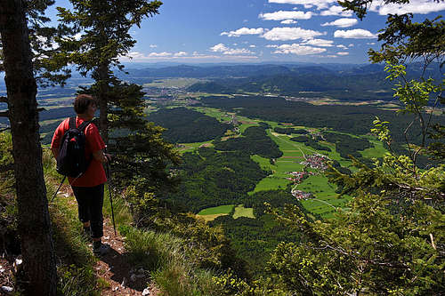
From Javornik meadow we continue by the marked trail which crosses the whole S slopes of Storžič. From the hut we descend into the nearby ravine, from above the water source the trail continues by exiting up on the other slope of the ravine. After gaining again some altitude it continues more or less horizontally, only the last ascent brings us on the crossing 1400 m (bench). From there we continue mostly horizontally towards the east, then the trail descends considerably and continues crossing below the rocks of Storžič. With some ups and downs we get to the nice water source, where the trail turns right and starts ascending towards Kališče. Through dwarf pines it reaches the ridge above the hut (highest point of the tour) and then comfortably descends to the hut.
Extension: Climbing the summit of Storžič from Javornik meadow is not difficult (750 m up, 2 h 15 min), the descent towards Kališče hut is steeper in the upper part. Altogether it's some additional 1 h 30 min.

|
To continue from Kališče towards the east, we must first descend from the hut some 5 min along the S ridge and on the branching take the left trail, which immediately starts descending. It soon reaches the bottom of Suha valley, crosses it on some 1400 m and then with another crossing reaches the forested southern ridge of Lanež. We go around it and on the other side continue almost horizontally to the hut in Hudičev boršt.

|

|
The section to Sv. Jakob church is quite long, but with only a slight altitude gain and much of descent. From Hudičev boršt we first cross the SE slopes of Zaplata, gain the main ridge NW of Javorov vrh, cross the W slopes of this mountain (or climb on its summit and by the SW ridge down), and continue towards the SW on the broad saddle between Javorov vrh and Potoška gora. from the saddle our route crosses the N slopes of Potoška gora and finally descends by the W ridge to the church and the nearby hut.
Extension: We can easily gain the summit of Javorov vrh (additional 15 min, nice view) and the summit of Potoška gora (additional 15 min, no panorama).

|
|
The last section of our tour is the descent from Sv. Jakob to the parking lot above Preddvor (above the Turn castle), using one of many tourist trails.