
-
 204093 Hits
-
 96.75% Score
-
 62 Votes
|
|
List |
|---|---|
|
|
Overview
Welcome to the Colorado Winter Fourteeners page!
There is a chance things may not make sense as some additions or changes may be incomplete depending on where they are left at the end of a day or work week. Please be patient and frequently check back with us on a regular basis as we'd like to help you be as educated as possible as you navigate Colorado's alpine terrain. Also, we now have firsthand accounts to every Colorado 14er and look forward to passing along those findings to you, the climbing community.
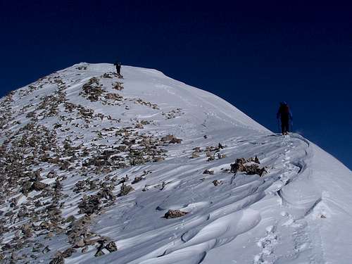 Climbing Sherman in winter.
Where to Start?
This is the common question among people venturing into Winter Fourteeners for the first time. These peaks are among the easiest, shortest, and most likely to provide you with a positive first experience.
| PEAK | WINTER ROUTE(S)/NOTES |
| Quandary Peak |
East Ridge- This may be the most popular winter 14er route in Colorado. This route can be completed without crossing avalanche slopes if proper precautions are taken at treeline. The north/northeast facing slopes above the common exit from the trees(summer trail area) have slid from time to time. Avoid them by going far left and gaining the ridge down low. In January 2008, there was a packed snowshoe trail to treeline. This is a common occurrence with Quandary's popularity, but go prepared to break your own trail. You can drive within 0.1 miles of the summer TH. West Ridge- 3rd class in the summer, but a demanding, technical challenge during winter. Venturing off the ridge proper onto the South Face may put you into avalanche terrain depending on conditions. Rope and a rack are advised. The winter closure can add up to 2.1 miles depending on recent wind scouring of the road. Inwood Arête- A mild technical route(5.4- 3P) in the summer, but a potentially dangerous, challenging adventure during the winter months. Expect to deal with technical terrain and possibly loaded avalanche slopes getting to and leaving the 5th class sections of the climb. Rope, rack, and avalanche gear/avy knowledge strongly recommended. Pulling this off during the winter months is a major accomplishment! Expect to add 2.1 miles onto this hike in winter. |
| Mount Sherman |
East Slopes- Fourmile Creek is a popular hike during the winter months. The typical winter winds typically make for a less than demanding snowshoe. The steeper slopes leading to the Sherman-Sheridan saddle can slide. This wasn't the case in December 2006, but this is prone to constant changes. Sherman's East Ridge over the unranked bicentennial, White Ridge, will provide safe passage. The road is plowed to Leavick, but snowdrifts can add extra mileage onto your hike. West Slopes- This is a slightly more arduous way to hike Sherman in the winter as the Iowa Gulch Road is less likely to have a trench in place. Sherman's West Face is the major avalanche hazard on this route, give it a wide berth if you're concerned and you shouldn't have issues. The slopes leading to the saddle with Sheridan are normally wind scoured. The road is plowed to the ASARCO mine, add 4.8 miles onto your hike. |
| Mount Lincoln |
West Ridge- Lincoln's standard, summer route also stands as a fine, single day endeavor. There are multiple options to reach this frequently windy finishing stretch. If one desires to stand on top of Cameron en route, hiking to the Democrat-Cameron saddle is a fine choice. The snowfield beneath this saddle can be a substantial avalanche path. We found safe passage in the rocks to its immediate right in January 2008. From there, the route is commonly wind-scoured and free of snow. Northeast Shoulder- This more uncommon way to climb Lincoln is a feasible, winter route. Getting to the upper section of ridge be may tricky. One must need to negotiate the Lincoln Ice Falls, northeast facing cliffs, and private property to the east of the massif. The Lincoln Amphitheatre, while frequently wind scoured, is a major avalanche path when loaded. Winter TH's- Lincoln, Bross and Democrat: Paris Mill- The Kite Lake Road is plowed until the Paris Mill, 2.5 miles short of Kite Lake, in the winter. Montgomery Reservoir- The road is plowed to the reservoir in winter. Occasionally, there are snowdrifts blocking the road right after a storm. |
| Mount Bross |
West Slopes- Bross' most obvious ridge route, as viewed from Kite Lake, is typically a screefest as the winds routinely remove all the snow above treeline from the Mosquito Range's highest massif. The "S" Gully on the ridge's north side has been known to be a safe route on occasion as it is extremely wind hammered. You'll have to judge the validity of this statement on the spot as conditions are consistently changing. Northwest Ridge- Running the ridge from Cameron is 100% safe if one sticks to the crest of the ridge. It is an excellent way to connect Bross with a climb of Lincoln and Cameron. |
| Mount Democrat |
The most interesting peak of the Decalibron group holds a few, intriguing surprises. East Ridge- This route is thought to be straight forward, but that is not the entire truth. Be careful of the snowfield as mentioned in the Lincoln section. Also, the most exposed sections on the ridge are very icy. Crampons are advised. The Southeast Ridge bypasses both of these obstacles, and might be a safer route to gain Democrat's summit. |
| Mount Bierstadt |
West Slopes- This was Colorado's most popular winter fourteener route in the days when the road was plowed all the way to Guanella Pass. Bierstadt's western slopes route are another Colorado windblown route. Avalanche danger is low, but not completely non-existent. Areas close to the north face, on the far, left side of the slopes may be a starting area for avalanches under certain conditions. Winter TH's: Guanella Pass Road- Plowing on the north(Georgetown) side stops 1.5 miles short of the pass at the Naylor Lake turnoff. |
| Pikes Peak |
Northwest Slopes(Crags Route)- Potentially a very windy route which lingers above 13,000' from the Devil's Playground TH to the summit and back. There is one gully just above treeline which could slide, but it's typically snow-free and would need a serious storm to pose a threat. The road is plowed to Rocky Mountain Camp, 1.9 miles short of the trailhead. It is common to drive all the way to the TH following older tire tracks. Barr Trail- A long route at 25.8 miles and 7800' vertical. Barr Camp is available as an overnight camp. **The summit building is open on days which the train is running**. |
| Grays Peak |
North Slopes- A deceptive, potentially dangerous route to the unaware as two major avalanche paths guard Upper Stevens Gulch. The first is the main, northeast facing gully coming off Kelso Mountain before reaching Stevens Gulch TH. From down low, this path looks far enough away to not pose a threat. I personally saw this slope run big in November 2010, covering the road in debris. The second is the southeastern slopes of Kelso Mountain. Stray from the summer trail well before reaching Kelso to avoid this hazard. The upper mountain is typical Grays, lots of scree or an easy ridge to the summit. Expect to add up to 6.0 miles and 1450' vertical to this climb depending on road conditions. Southwest Ridge- Said to be another straightforward route. Giving the Northwest Slopes of Cooper and Ruby Mountains a wide breath may prove to be a good idea. The winter closure is at the Montezuma-Peru Creek junction. |
| Torreys Peak |
South Slopes- Frequently combined with Grays, and is a simple finish from its neighbor's summit. Getting there, see Grays' North Slopes beta, can be tricky during certain timeframes. Reclimbing Grays on the descent may be necessary depending on snow conditions. Expect to add up to 6.0 miles and 1450' vertical depending on the winter road closure. West Ridge- This route, from easily accessible Loveland Pass, is increasing in popularity and might be the safest path to Torreys summit in winter because of wind scoured terrain. Don't be fooled by the low amount of snow, many sizeable cornices decorate the north through east aspects on the approach. A car shuttle from the I-70 TH back to Loveland Pass is common amongst groups on this route. Chihuahua Gulch- Said to be another reasonable winter route. |
| Mount Evans |
West Ridge- A seemingly tedious route, but it holds a bit more character than expected. Avalanche danger is low, possibly non-existent depending on the day. There are steep gullies one can use to exit the Scott Gomer Drainage that could slide when properly loaded, but there are mellower options to avoid said routes. The upper West Ridge is a long, boulder weaving and hopping affair. The winter road closure is 1.5 miles short of Guanella Pass on the north side. Mount Evans Road- This long route, 20+ miles/3700' vertical, is expedited by many sections of clear road. Off-road shortcuts might be prudent to save time and avoid avalanche paths. |
Single Days
Up for a little more? These peaks are the next step from the "easiest" ten. They're not overly challenging, but don't expect any gimmies in this group.
| PEAK | WINTER ROUTE(S)/NOTES |
| Mount Elbert |
East Ridge- This is Elbert's most popular winter route, and can be crowded(for winter) at times. The East Ridge is the safest route up Elbert during a normal winter. There is no avalanche danger on this route. A well-broken trail can typically be found all winter long except immediately after a snowstorm. This route is 11.2 miles and 4,850' vertical from the South Mount Elbert TH. Northeast Ridge- Want to avoid the winter Elbert crowds? This is a route for you! The Northeast Ridge route is not popular whatsoever as the summer TH is 4 miles past the winter road closure, adding 8 miles RT to your adventure. The route is avalanche safe if one sticks to the ridge proper above treeline, but potentially dangerous terrain lurks nearby. Come prepared for an overnight trip. |
| La Plata Peak |
North Ridge- The North Ridge Direct is the safest route and usually has little to no avalanche danger. Under unusual conditions one slope could slide. This variation is recommended over the popular summer route via the Northwest Ridge/Slopes. That route spends significant time above treeline in prime avalanche terrain. Ellingwood Ridge- La Plata's most interesting summer scramble turns into an arduous, technical outing above 13,000' in the winter months. Efficient climbing and rope work are necessary to avoid being benighted on the ridge. Potential avalanche terrain may hinder/prevent aspiring parties from gaining the ridge proper. Come prepared for a potentially cold night out in the Colorado high country. Winter TH's: Lake Creek- This TH is accessible year round, and doesn't add additional mileage to a winter attempt. |
| Mount Antero |
West Slopes- This route crosses beneath several avalanche runouts, but the danger is often mitigated, and commonly avoided, as Antero's West Face is commonly a barren wasteland of frozen scree providing many safe options. Pick a spur/ridge, and go for it. This route is 10-11 miles and 4,900' vertical from the Baldwin Gulch TH. Winter TH's: Baldwin Gulch- This TH is accessible in the winter months. Every time I've hiked up this road in the winter, there's been tire tracks starting up the road, then signs of the vehicle getting stuck a short distance up the hill. Don't waste your time, park at the bottom! |
| Mount Shavano |
Southeast Ridge- Shavano's most accessible winter route is a steep slog. The climb to ~13,100' is a snowshoe grind and wondrous kickstepping outing. The final section to the unranked 13er, Espirit Point, and up Shavano's Southeast/East Slopes is a long talus hop. You must reascend Espirit Point on the hike out. This route from Angel of Shavano TH is 6.4 miles and 5,570' vertical. Angel of Shavano- One of the Sawatch's most popular snow climbs is a winter wild card. There is a possibility you could have an enjoyable climb. Be aware, this snowfield has the potential to produce powerful slab avalanches. Come prepared to properly evaluate current conditions. Add up to ~6 miles RT to the Blank Gulch approach hike in winter. Winter TH's- Shavano and Tabeguache Angel of Shavano- This TH is accessible year-round. Chaffee County 240 is plowed to the Angel of Shavano Campground, immediately after the TH. Blank Gulch- The roads are plowed until the Chaffee County 250 and 252 intersection leaving you ~3 miles short of the Blank Gulch TH, and adding ~6 miles RT to your outing. |
| Mount Yale |
Southwest Slopes- Starting from the Denny Creek Trailhead, Yale's standard summer route, with minor variations, is an excellent choice in the winter months. Avalanche slopes lurk at treeline and in the gully leading to the upper Southwest Ridge. Heavily treed terrain and rocky ribs are available to avoid the potentially hazardous areas. East Ridge- The East Ridge from the Avalanche Gulch Trailhead is the safest route on the mountain, and usually has no avalanche danger if you stay on route, but the ridge is rather long and tedious. Winter TH's: Denny Creek- Chaffee County 306 is normally plowed to the Denny Creek TH. There was a winter few years ago when plowing stopped at the Avalanche Gulch TH, but that hasn't been the norm. Call the Chaffee County Sheriff's Office if you're unsure of the current road conditions. Avalanche Gulch- Chaffee County 306 is plowed to the Avalanche Gulch TH year round. |
| Tabeguache Peak |
East Slopes- As an add-on to a climb of Shavano, this is the most efficient way to climb Tabeguache in the winter. Take care with the final slope to Tabeguache's summit immediately after a storm. There is avalanche potential. West Ridge- Rocky, and full of slow travel, this is another safe way to reach Tabeguache's summit. You are able to drive all the way to the Angel of Shavano TH(see Shavano section). |
| Mount Columbia |
West Slopes- A pain of a route to reach, but an easy, wind-scoured cruise once you're there. Chaffee County 365 to the North Cottonwood TH is popular with snowmobilers. Upon reaching the wilderness boundary/TH you're on your own. Follow the obvious, open cut along the trail until things become obscured in the flatter sections ~11,200'. Wallow to the bottom of Columbia's West Slopes and enjoy the cruise from there! Snowy patches dot the never-ending summit ridge. Avalanche terrain is avoidable on this route. Southeast Ridge- This long, snaking ridge is Columbia's safest winter route. Go to the Harvard Lakes TH, and take the Colorado Trail north for a 1/2 mile until you reach the Southeast Ridge. You should be able to avoid avalanche slopes on this route. This route is 14.4 miles and 5000' vertical in winter. Winter TH's: Harvard Lakes- Plowing stops at the National Forest Boundary, 5.4 miles from the stoplight in Buena Vista. Expect to add up to 2.4 miles RT to this approach in winter. It has been possible to drive to Harvard Lakes at times in past winters. Use your own judgment. North Cottonwood- 1.6 miles further down Chaffee County 365 from the Harvard Lakes, this TH is not typically reachable in winter. Expect to add up to 5.6 miles RT to this approach during winter. This road is frequently packed down by snowmobilers. |
| Humboldt Peak |
East Ridge- The safest, easiest winter route to a Fourteener summit in the Sangres, Humboldt's East Ridge presents you with seemingly unlimited variations in your battle against postholing and the wind. And oh, can it get windy up there! Follow the South Colony Road to wherever you decide to head north for the East Ridge. There are many options between the Rainbow Trail and the final reasonable exit point(~10,800'), roughly 4 miles up the road. This road is popular with snowmobiles, but isn't guaranteed. I've personally climbed Humboldt in February 2009 without donning snowshoes, and also wallowed through two feet of fresh snow to reach a high camp at South Colony Lakes two Februarys later. Winter TH's: South Colony- This TH is accessible year round. The plowing stops at the left turn 0.3 miles below the TH, but we've never had issues driving the last couple minutes to the parking lot. There is room on the side of the road if you would like to park at the turn. |
| Culebra Peak |
Long locked up by numerous private property owners, but open once/twice a winter thanks to the efforts of Ken Nolan. Northwest Ridge- An anomaly, but nothing's ever been normal concerning Culebra. Under the current ownership(2014), winter access is allowed to Culebra after they put a track to the road's end, on acceptable days, with a snowmobile. It may be necessary to gain the upper Northwest Ridge as quickly as the open slopes above the 4wd TH are avalanche prone. Higher up, a rocky, up-and-down ridge grant you safe access to this elusive summit. Culebra costs $200 to climb in winter. |
| Redcloud Peak |
South Ridge- The easiest, and safest, way to climb Redcloud in winter is as an out-and-back addition from Sunshine Peak. The ridge is wind scoured closer to Redcloud, but makes up for that during the descent/re-ascent of Sunshine's North Ridge. Northeast Ridge- Redcloud's standard summer route is avalanche-prone, and not recommended. You must cross several sizable avalanche paths and finesse a long, north facing bowl above treeline to reach the base of the safe Northeast Ridge @ 13,020'. The Cinnamon Pass Road is closed 4 miles below the Silver Creek/Grizzly Gulch TH(8 miles RT) and you must cross under more avalanche paths along the pass road. |
| Sunshine Peak |
East Ridge- Sunshine's arduous East Ridge is the safest, easiest winter route in the San Juans. Steep from the first step, this route can be safely climbed in all conditions if one avoids the open sections below treeline. Stick to the ridges above treeline and you'll have a safe, enjoyable climb with top-notch San Juan views. Avalanche terrain lurks nearby, stick to the route. Example: In February 2014, I set off a big avalanche from Sunshine's summit by slamming my trekking poles into the snow. The vibrations propagated out to the Southeast Face(next to the East Ridge)triggering the avalanche, and ripped away out of sight. Shocked to say the least! Winter TH's Mill Creek- The Cinnamon Pass Road is plowed past the Mill Creek Campground making it accessible year-round. |
Into The Night
These mountains may re-define how you view a day, starting and finishing your climb in the dark. You may find an overnight camping trip to be beneficial.
| PEAK | WINTER ROUTE(S)/NOTES |
| Mount Massive |
East Ridge- The East Ridge route from the Fish Hatchery is the most popular route in the winter. A trail is commonly broken to the Colorado Trail by recreational skiers and snowshoers. From there, rolling, possibly confusing, terrain brings you to the East Ridge. We found strenuous trail breaking thru exceptionally deep powder in this section in February 2012. Wind scoured terrain makes the final 2000' vertical go quickly. Expect a long, full day. Winter TH's: Fish Hatchery- From Third and US 24 in downtown Leadville, go 3.6 miles Southwest on 24 to CO 300. Turn west and go ~3 miles to the Fish Hatchery, on your left. Stay left in the Hatchery until you find the TH for the Colorado Trail, and eventually Mount Massive, it's in the back. |
| Mount Harvard | Short and easy in the summer, Harvard tosses aside these characteristics when the winter snows lie deep. Expect to work hard for this Sawatch giant!
South Ridge- Is there a standard winter route on Harvard? If so, this technically easy way might be the leading candidate. North Cottonwood Creek Road is a popular place with skiers and snowmobilers, but expect to be on your own upon leaving the road. We found Horn Fork Basin to be a unrelenting wallow, below and above treeline, in December 2012 and 2016 as Columbia blocks the wind from blowing excess snow over its flanks. Come prepared for 16-20 miles of hard work. East Ridge- Shorter than the South Ridge, this route has gained popularity over the past few winters. The 4wd road leads one all the way from the Arkansas River Valley to the Colorado Trail intersection, and a potential spot for high camp(~11,000'). A couple spooky spots lurk near/at treeline, but solid route finding choices are helpful in avoiding them altogether. Scrambling on the Upper East Ridge is the route's crux as the snow covered slabs may force one onto the avalanche prone North or South Face at times. Use your own judgment in determining which passages are safe under the current conditions. In February 2017, we were able to rock hop under the crux tower without worrying about open, loaded slopes lurking lower on Harvard's impressive South Face. This option may not have been available after the next storm. Some parties may appreciate a rope here. Winter TH's: Harvard Lakes- Plowing stops at the National Forest Boundary, 5.4 miles from the stoplight in Buena Vista. Expect to add up to 2.4 miles RT to this approach in winter. It has been possible to drive to Harvard Lakes at times in past winters. Use your own judgment. North Cottonwood- 1.6 miles further down Chaffee County 365 from the Harvard Lakes, this TH is not typically reachable in winter. Expect to add up to 5.6 miles RT to this approach during winter. This road is frequently packed down by snowmobilers. Frenchmen Creek- FS 386 is plowed for 0.3 miles from its intersection with US 24. Expect to add up to 2.8 miles RT to your outing. |
| Blanca Peak |
Unlike the other fourteeners in the Sierra Blancas, Blanca is normally a mild climb during the winter months. The North Ridge presents an obvious path to the summit and the commonly rocky Northwest Face may be a feasible option if avalanche conditions are reasonable. The slope leading to the Blanca-Ellingwood Point saddle can be problematic, and holds potential avalanche concerns. Also, this is a long, exposed hike and one should come prepared for an overnight adventure. Winter TH's: Lake Como Road- The infamous Lake Como Road is one the greatest variables when climbing in the Western Sierra Blancas during the winter. It's not plowed, and the snow closure is continuously changing. Many parties are able to drive to the 8800' and 9700' obstacles in winter. We were able to drive ~10,400', just short of Jaws I in March 2006. Also, infrequently parties find major storms have blocked the road at CO 150 turnoff, 6.8 miles short of Lake Como. These final two examples are exceptions from the norm. |
| Uncompahgre Peak |
East Slopes- Uncompahgre's standard winter route is typically very safe. Minor route adjustments are necessary to avoid certain slopes during unsafe conditions. The final, east facing slope to reach the upper plateau can be dangerous after big storms. 15 miles, 5000' vertical RT. West Face- This scree-loaded slog may be Uncompahgre's safest winter route upon reaching the upper mountain. Choose any route thru the scree. The large snow gully on the climber's left may be passable or hazardous. Use your own judgment. Getting to this route involves traveling many more miles than the Nellie Creek approach and crossing multiple, potentially dangerous avalanche paths in Matterhorn Creek Drainage. Winter TH's: Nellie Creek- The Nellie Creek 4wd road is not plowed during winter, but is popular with snowmobilers. Expect a hike of 15 miles and 5000' vertical. |
| Mount Belford |
Northwest Ridge- This mellow, enjoyable route in the quickest, easiest route to Belford's summit in winter. There's an enormous avalanche chute coming off Pecks Peak at treeline, but it usually doesn't hold any substantial snow. There are also several chutes to the west of Missouri Basin that have slid with a heavy snowpack. The remainder of the route is avy safe. Winter TH's- Belford and Oxford Missouri Gulch- Plowing on Chaffee County 390 stops 4 miles from US 24, 3.7 miles short of the TH. Expect to add up to 7.4 miles RT to your outing. This is a popular road with snowmobilers, and aggressive drivers. I wouldn't be surprised if you're able to shave a couple miles off your hike by following someone else's tracks. |
| Mount Princeton | The standard route is a fairly safe winter climb, but stay directly on the ridgetop rather than the road between the radio towers and Tigger Peak. This is quite tedious, especially if you are breaking trail, but this route avoids the avalanche chutes. Also be aware that reaching the Chalet on Mount Princeton requires crossing a big avalanche chute. Unless avalanche danger is low, bringing a tent (if overnighting) is recommended. |
| Mount Oxford |
West Slopes- On Belford, why not Oxford also? This route is possibly the easiest way to Oxford's summit in winter. Most parties find a clear, windblown saddle between the two. In February 2012, I spent 2.5 hours slogging thru quad deep snow while adding on Oxford. Hopefully you'll find snowless tundra on your route! East Ridge- Starting from the Colorado Trail access point on Chaffee County 350, Oxford's most straightforward, shortest route may not be the easiest way to go. Multiple parties have reported hours and hours of bottomless wallowing! |
| Mount Lindsey | You can drive to the Singing River Ranch in winter and from there it’s a fairly long climb. The route is said to have moderate to low avalanche danger as long as you stick close to the ridge on the later part of the route. The ridge can have some tricky scrambling in winter. |
| Mount of the Holy Cross | Holy Cross is a technically easy mountain in winter and fairly safe, but the climb physically hard and demanding because of the road closures. The crux of the standard route is getting down from Halfmoon Pass to Cross Creek and then back up again. Other than the area between Halfmoon Pass and Cross Creek, there isn't much avalanche danger, but since there is little traffic in winter, expect to break trail the entire way. Going up Cross Creek from that trailhead is another alternative. |
| Huron Peak | Obscure and reclusive, Huron probably isn't the first fourteener which comes to mind. Give it more thought, it's a fine winter trip!
Northwest Slopes- A peaceful route meandering up the expansive Clear Creek drainage. Follow the signed Huron Trail at the 4wd summer TH split with the Apostles, and make your way to treeline. How does Huron's Northwest Face look? Safe? Continue in the direction of the summer route and pick your way up to the ridge. Loaded? Make your way over to the West Ridge and slog your way through loose talus to the summit ridge. I found this route to be the safest route in December 2011. Yeah, the talus is a pain, but not that bad, and the views of the Apostles aren't shabby either! Finish the ridge, and the summit's only a few minutes away. North Ridge- Huron's safest route in funky avalanche conditions. Find a route through the trees soon after leaving Winfield and gain the ridge early. The ups and downs can be tiring on the way back, but the trade-off is more than acceptable. Winter TH's: Winfield- This TH is buried deep in the Sawatch during the winter months. Plowing on Chaffee County 390 stops 4 miles from US 24, 7.8 miles short of the TH. Expect to add up to 15.6 miles RT to your outing. This is a popular road with snowmobilers, and aggressive drivers. I wouldn't be surprised if you're able to shave a couple miles off your hike by following someone else's tracks. Even if you're force to park at the winter closure, miles on this road go quickly following snowmobile tracks! |
Avalanche Traps
These peaks can be quite docile or underrated during dry seasons, but they live in avalanche terrain in the winter.
| PEAK | WINTER ROUTE(S)/NOTES |
| Castle Peak | The Northeast ridge itself is a fairly safe winter route once you get on it, but the approach to the ridge is often not safe and has very high avalanche danger. Montezuma Basin has no avalanche free routes and the approach will be the most dangerous part. The road is open to Ashcroft and requires an extra 5.0 miles round trip in winter. The North Couloir is probably the easiest winter route, but only during extremely stable time periods is this a safe route. The route would be extremely dangerous in prime avalanche conditions. |
| Longs Peak | Colorado's most popular summer fourteener is a difficult, avalanche prone mountain in the winter. Be aware of wind storms on Longs. Heavy, damaging, and potentially lethal winds can appear on this sentinel's slopes in a moment's notice. All routes are technical in winter, and you may find a rope and rack beneficial on the upper mountain. Use your best judgment.
Keyhole Route- Unlike summer, there is more to worry about in the winter months than someone kicking rocks on you. Variables abound. Hike to the Keyhole, that's the simple part. Now what? The slabby snowfields on the West Face have taken lives in the past. Be careful crossing this section. The Trough is normally rocky and safe. The Narrows and the Homestretch are the greatest variables of a Longs climb. Icy one weekend, bone dry the next, and covered in 18" of snow the following weekend. Come prepared for anything. Keep an eye on the avalanche slopes on this route. They're all short and sweet, and live directly above cliffs. The Trough- Longs' safest and easiest winter route? A time-consuming snowshoe through Glacier Gorge brings one to the Trough. Cliffs guard the base, pick a route through, then proceed upwards if conditions permit. Join the Keyhole Route when the lower snowy Trough reaches the upper rocky Trough. Proceed with caution on the Narrows and Homestretch. North Face- Longs' easiest technical climb, this route presents multiple problems in the winter. While only 5.4, the potentially awkward crux can be difficult with crampons and slick holds. Higher up, snowfields and rock steps bring one to the summit. Keeping a close eye on avy conditions is imperative, the snow pieces you kick from your steps fall over the Diamond. Where would an avalanche, even a small one, take a climber? This route spends a majority of the winter in the shade. It would behoove you to dress warmer than the forecast suggests. The Notch, Kieners et al- These east facing routes are dangerous mini-expeditions in winter. They should only be attempted by efficient moving parties who are experts in rope work, avalanche awareness, and winter camping. I'll enjoy reading their TRs at home! |
| Mount Sneffels | Seductive in nature while driving south on 550, take care with this beauty. Avalanche terrain is abundant above treeline in Yankee Boy. Recent and current conditions will rule the day higher on your route.
South Slopes- Sneffels' most frequented route in winter, if such a thing exists. A long hike until ~12,000', and then things get interesting. Kismet's chutes threaten the approach in certain conditions. Giving the mountain a wide berth in those periods may prove to be a wise decision. Making the turn to Lavender Col, safe, low-angled slopes are left behind. The remainder of the route to gain Sneffels' summit travels through avalanche terrain. Is the slope to Lavender Col safe? Are there enough rocks showing? Have the snow layers bounded together well? Above the col, the tight couloir may be avoided, for the most part, by exiting left up a small, short chute onto Sneffels' South Face after ~150' vertical. The South Face/Southeast Ridge may feel a tad airy for one's tastes, but it'll help avoid the awkward, snow-chocked third/fourth-class step to gain the summit ridge. Some parties may find a rope useful up here. Southwest Ridge- Could be loads of fun....or loaded with avalanche danger. The base of this route is normally engulfed by 1000'+ vertical of avalanche slopes from the north and south. If one is able to gain the ridge, what kinds of "got ya's" await in the numerous, small couloirs you cross en route to the summit? Travel along this route is only advised in drought winters, like 2012. Expect a full on expedition style climb if the route is safely finessed in a normal winter. Winter TH's: Ouray County 361 is closed at Senator Gulch during winter by the Revenue Mine, and re-opens May 1st. Expect to add 8.0 miles and 1560' vertical to your outing. The mine employees maintain the road from the closure to the 2wd TH in Yankee Boy Basin. Roundtrip is 15 miles/5000' vertical, and this is reasonably done in a day with the easy road miles. **Side Note** Please do not ask the mine employees for rides up and down the road. Mine management has terminated multiple employees for this in winter 2015. They have ongoing disputes with ice climbers along "their" road. |
| Challenger Point | The Willow Creek Route is said to be a reasonable route with moderate avalanche conditions. |
| Missouri Mountain | The standard summer route is avalanche prone. The best winter route is the West Ridge from Lake Fork and Clohesy Lake. You can avoid avalanche danger if you search for a route through the trees and then exposed ribs. The crux of the route is an exposed step near the summit and might require a safety rope depending on snow/ice conditions. |
| Handies Peak | The Southeast Ridge via Boulder Gulch is the most frequently climbed route in the winter. There is a quarter-mile stretch of terrain at treeline in Boulder Gulch which is avalanche prone and should be avoided whenever the avy danger is substantial. Unlike its summer reputation, Handies is not an easy peak in the winter. |
| Ellingwood Point | The overlooked Fourteener in the Sierra Blancas, this snow loaded giant stands as a tricky puzzle to the uninitiated.
South Face/Southeast Ridge- Consistently changing, Ellingwood's South Face ranges from a fun romp through rock outcroppings to a giant, white death trap. The Southeast Ridge is an option, one may get forced off the ridge onto the South Face. Constant snow evaluation is critical. |
| San Luis Peak | The best winter route is from West Willow Creek. San Luis may be easy in summer, but is a long committing climb in winter with lots of trail breaking, unless the road happens to be open all the way to the mine (which does happen in some years). |
Stepping Your Game Up
These constantly changing puzzles may present the intrepid climber with a whole new set of challenges. Understand what you're presented with before moving forward.
| PEAK | WINTER ROUTE(S)/NOTES |
| Crestone Peak | The South Face Route is doable, but avalanche conditions vary considerably from year to year. An approach from Cottonwood Creek may be the best route in winter as the avalanche prone slopes leading to Broken Hand Pass may not be the best idea. The Northwest Couloir Route can also have significant avalanche danger and can be difficult and icy as well. During drought years, these peaks may have so little snow that they can be climbed mostly on rock, at least on south facing slopes. These peaks are in the rainshadow of the San Juans and are therefore susceptible to drought. In heavy snow years, the avalache danger can be very high to extreme. |
| Crestone Needle | The standard route is doable, but avalanche conditions vary considerably from year to year. The northeast facing slope to Broken Hand Pass is very dangerous under normal conditions making the Cottonwood Creek Approach the best option. The South Couloir can have high danger. During drought years, these peaks may have so little snow that they can be climbed mostly on rock. These peaks are in the rainshadow of the San Juans and are therefore susceptible to drought. In heavy snow years, the avalache danger can be very high to extreme. |
| Kit Carson Peak | The safest route is the South(Cole's) Couloir from Spanish Creek. Variations using the rocks on the climber's left may be beneficial to protect oneself from possible sluffs and avalanches. |
| Snowmass Mountain | Snowmass is a serious winter climb. It isn't that difficult, but is considered dangerous. The slopes above Snowmass Lakes are considered to be an avalanche trap. In winter, add 2.0 miles round trip. The Lead King Basin Route is said to be possibly the safer route because the prevailing winds tend to strip that side rather than load it, but the approach is still long and still crosses many avalanche paths. |
| Little Bear Peak | In winter, the standard summer route-the West Ridge has no rockfall, but can have avalanche danger. When conditions are stable, the route isn't supposed to be that much harder in winter than in summer, but have a good avalanche forecast. The Southwest Ridge is typically the safest route on the mountain during winter because the avalanche danger is usually lower. |
| Wilson Peak | Wilson Peak is a dangerous, avalanche prone climb in the winter months, and picking an appropriate weather window may prove to be key to one's success. The South Face and Southwest Ridge are the most frequently traveled routes, as both long, single day and overnight efforts, with an approach dropping into Upper Bilk Basin over the Lizard Head-Cross Mountain saddle. Approaching the peak via Silver Pick and Lower Bilk Basins is not recommended due to the increased amount of time spent in avalanche terrain.
Winter TH's: Cross Mountain- This TH is located on CO 145, 2.0 miles west of Lizard Head Pass and is accessible in the winter months. |
| Wetterhorn Peak | One of Colorado's rougher Fourteeners in winter, this sentinel San Juan beauty is buried deep in avalanche country.
Southeast Ridge- Very much like a crescendo, this route's character and difficulty builds as it progresses deeper into the backcountry, climaxing on Wetterhorn's stunning summit. From your high camp in Matterhorn Creek, meander up the drainage, avoiding the open slopes on the thirteener, Broken Hill, before gaining treeline. Above treeline, the drainage is threatened by avy slopes on both sides simultaneously in two places. Choose your route carefully. The final 25-degree slope to gain Wetterhorn's Southeast Ridge wasn't too menacing in January 2015, but it can be a dangerous place under different conditions. Scrambling through the rocks from ~13,400' to Ship's Prow is taxing and slow, but worthwhile to avoid the avalanche runouts on the Southwest Slopes and the deadly East Face. Wetterhorn's infamous summit scramble is typically a mixture of snow dodging and rock scrambling, determined by recent snowstorms and wind conditions. Some parties may appreciate a rope here. Enjoy the summit! Winter TH's: Engineer Pass Road Closure- The winter closure gate is immediately after the lower Nellie Creek TH, 5.2 miles after leaving Lake City. Expect to add 13.2 miles RT during a normal winter. Avalanche conditions on the road between the closure gate and Capitol City(~4 miles in) vary greatly depending on the year. |
A Different Lifestyle
Safe routes may not exist on these mountains. Expect to spend a significant amount of time in avalanche terrain.
| PEAK | WINTER ROUTE(S)/NOTES |
| Mount Wilson | Mount Wilson is an avalanche prone and very serious climb in winter. There seems to be no really "safe" routes up this one in winter and the climb is long from any route. |
| El Diente | El Diente can be an avalanche prone climb and is a very serious climb in winter. There seem to be no really "safe" routes up this one in winter and the climb is long from any route. Kilpacker Basin is said to be the best winter route, but is still a very serious climb. |
| Maroon Peak | A serious climb in winter on an avalanche prone mountain. All routes have high avalanche danger. |
| Capitol Peak | Capitol is a big climb. The Northeast Ridge is an intimidating place to be in winter.
Northeast Ridge- Where to start? The Knife Edge Ridge is an uber-serious, balance beamesque route on Colorado's most technical fourteener. Staying on the ridge direct is mandatory the majority of the way with minor exceptions to avoid cliffy areas. A rope and rack are STRONGLY RECOMMENDED. We found simul-climbing to be the most efficient method of travel. Above treeline, you are consistently in avalanche terrain. It may be mitigated by staying far right in the trees until Moon Lake. Afterwards it's unavoidable until reaching lower-angled, rocky terrain on the slopes immediately below K2. Pick your path wisely. Approaches: Snowmass Creek- This is the safest, shortest and best overall way to approach Capitol's Northeast(knife edge) Ridge in the winter months. Avalanche terrain is avoidable on the approach if you camp in the trees ~11,060' or lower. Camping at Moon Lake leaves one exposed to the elements and potential avalanche runouts. The winter road closure is at Snowmass Creek, add 1.2 miles RT on this approach. Capitol Creek- Not advised as a winter approach to Capitol's Northeast Ridge as the ~1000' climb/descent to the K2-Daly saddle is a significant avalanche slope. Nonetheless, this is your best option to reach Capitol's North Face if you're in search of an Alaskan level technical climb. Minor variations from the summer trail will be necessary from time to time to avoid avalanche runouts. Plowing on the Capitol Creek Road stopped 5.9 miles, where the road turns to dirt, from CO 82. Add 7.2 miles RT to this approach in winter. |
| Mount Eolus | A serious winter climb, especially since the train only goes to Cascade Wye on certain days in the winter, adding 10.2 miles round trip. Eolus is an avalanche prone mountain. In winter, one of the least climbed 14ers. |
| Windom Peak | A serious winter climb, especially since the train only goes to Cascade Wye on certain days in the winter, adding 10.2 miles round trip. Windom is an avalanche prone mountain. In winter, it is one of the least climbed 14ers. |
| Sunlight Peak | A serious winter climb, especially since the train only goes to Cascade Wye on certain days in the winter, adding 10.2 miles round trip. Sunlight is an avalanche prone mountain. In winter, this is one of the least climbed 14ers.. |
| North Maroon Peak | North Maroon is a serious, avalanche prone mountain. All routes spend a considerable amount of time in avalanche terrain. |
| Pyramid Peak | Pyramid is a dangerous mountain home to a substantial amount of avalanche prone slopes. The amphitheater beneath Pyramid's North Face, commonly used to access both the Northeast and Northwest Ridges during the summer months, is one gigantic, avalanche prone bowl where climbers may struggle, or be unable to safely access the ridges above. The West Couloir has become the most frequented route for those looking to find a reasonable path to the summit in recent years. A large scree field on the couloir's left is an option to gain the Northwest Ridge ~12,700' without entering the couloir. Knowledge of the upper Northwest Ridge is highly recommended as the maze of snow gullies and cliffs can be quite confusing. A rope and small rack is recommended for the Keyhole. It resides above the junction of precarious avalanche slopes and a rocky gully. |
Help Requested
Thanks to all whom have helped with this page. Winter photos and albums are encouraged. I will add some on the mountains that have enough winter photos for an album, but many do not. Please contribute winter photos.
 South Ridge of Castle (early spring)
Other Related Info
Overnight Temperatures in the Central Rockies
Pikes Peak Weather Statistics
14ers Weather Links
Colorado Avalanche Information Center
Disclaimer
This is not a how-to page on winter climbing. It's merely a collection of winter notes meant to aid in planning winter ascents of the Colorado 14ers. Several climbers have been killed on these peaks. Technical and avalanche skills must be practiced before hand and proper equipment must be taken.
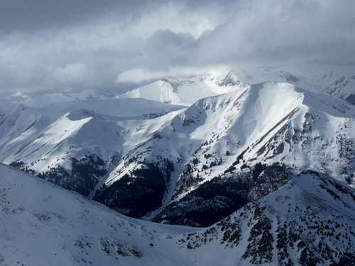 Fresh avalanches as viewed from La Plata Peak.