
-
 11167 Hits
-
 85.87% Score
-
 21 Votes
|
|
Mountain/Rock |
|---|---|
|
|
46.49671°N / 11.95940°E |
|
|
Hiking, Scrambling, Via Ferrata, Skiing |
|
|
Spring, Summer, Fall, Winter |
|
|
8045 ft / 2452 m |
|
|
Overview
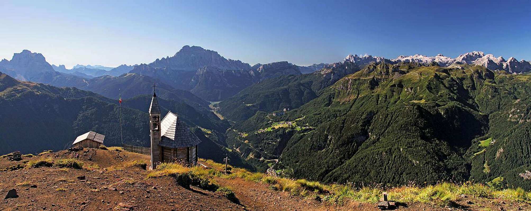
Despite its modest altitude, Col di Lana is one of the most known summits of Dolomites. Rising in the very center of Dolomites, Col di Lana excells with magnificent views all around - many of the highest summits of Dolomites stand around it just like on a parade. The second reason for being famous is much more sad. On its summit some of the most fierce fightings on the Dolomites mountain front took place during the World War I. That is why Italians also call it Col di Sangue (Bloody Mountain).
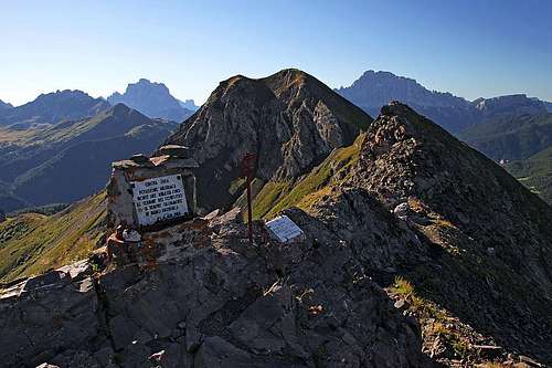
Col di Lana from Cima Sief
The Name
Don't be misled by the word "Col" in the name of our mountain. In French (and also English) language 'col' means indeed a 'pass' or a 'saddle'. But in Eastern and southern Alps the word is used for a 'mountain', 'summit'. Col di Lana is the Italian transcription, while the Ladinian is Col de Lana.
Why To Visit?
Col di Lana is a wonderful hiking summit. Many marked paths are reaching it from all sides, using mostly old military paths. As around the summit there are broad pastures, you can in addition to remains of military paths use also many shepherds paths - but mostly in the lower parts of the mountain, where the terrain is easily passable everywhere. In winter from the NW foresummit nice ski tours go down towards the west and north (and then east). Close to the road to Passo Falzarego's southern approach a picturesque Andraz castle stands. You can drive almost to it by car and do some sightseeing around.
A Bit Of Geography ...
Col di Lana belongs to the group of Fanes Dolomites. That one is much higher and rocky, showing some most excellent vertical dolomitic walls. But on the very southwest, in the wedge between the valley of Cordevole and Rio Andraz, the small subgroup of Col di Lana is hardly exceeding 2500 m (with Settsass, 2571 m). Even more to the northwest, you will find one of the broadest high meadows in Dolomites - Pralongiá. But that's already another story...
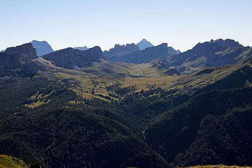
Col di Lana itself is connected with the higher summit of Settsass, 2571 m, by a long and distinct north ridge. It is grassy and flat, pastures are reaching just to it from both sides. Coming from the north, the ridge gently lowers to Passo Sief, 2209 m. Towards the south then the ridge rises more steeply on Cima Sief, 2424 m, which is considered the NW foresummit of Col di Lana. The connecting ridge is then quite steep and rocky, with considerable abysses towards the NE. Close to Cima Sief there is a ridge tower of approximately the same elevation (Dent de Sief), then a notch 2383 m and then finally the ridge rises to the highest point of Col di Lana. From Cima Sief a distinct ridge descends towards the west, in its lower part there are the bumps of Col de la Roda, 1901 m, 2030 m. From the summit of Col di Lana the main ridge continues down towards the east. The elevation 2221 m in it is called Cenglei. A few named points can be found also in the SE ridge, descending towards the nice village of Pieve di Livinallongo.
... And Of Geology

Summit rocks
Visiting Col di Lana you will notice immediately a big difference between the dolomitic rocks of the highest summits of Fanes group and dark, coloured rocks of Col di Lana. The latter is built of many different rocks of the upper Permian and Lower to Middle Triassic periods. At that time in the area of today's Cordevole valley the sea was deeper and atols, built of sediments were more on the edges of the bay. But in that deeper sea a significant volcanic activity took place. That added much to the lithologic complexity of mountains around Col di Lana. On top our mountain is build mostly of volcaniclastic sandstones and also of mid-triassic marls and siltstones. So, no dolomia principiale there and no big rock climbing challenges.
Panorama
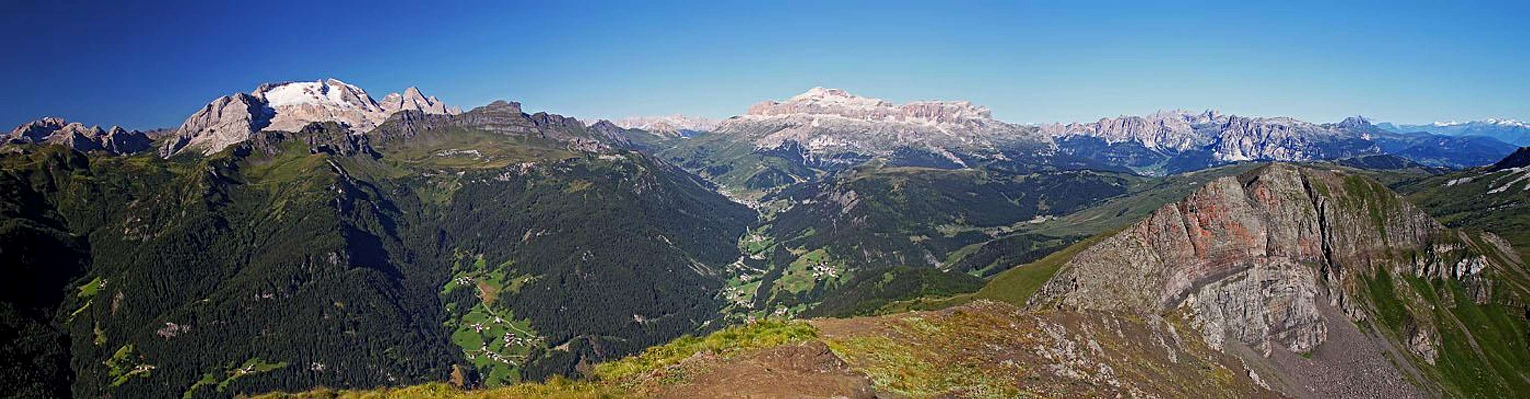
Being in the middle of Dolomites, and yet remote enough from the highest mountains, Col di Lana has one of the greatest panoramas in the region. And we are speaking of Dolomites mountains, not just of any region on this planet.
Towards the north
Towards the east
On the SW we shall first greet Marmolada, the Queen of Dolomites, shining with its white glacier above the ridge of Padon. Left of it we see Pale di San Martino, already quite distant and so a bit less impressive. Towards the SE the deeply cut Cordevole valley stretches. At its knee, near Alleghe, we see the popular lake and above it and the surrounding fore-mountains the whole broad curtain of Civetta. More towards the left there is the throne of Monte Pelmo and then in the E direction the whole group of Croda da Lago and Averau-Nuvolau. From behind Antelao and Sorapiss are rising their proud heads. Of Ampezzo Dolomites Monte Cristallo is well seen and of course the three Tofane, being more close to us. Left of them the highest summits and walls of Fanes mountains are seen. In the northern direction the nearby Settsass is stretching. Even if it is broad and a bit higher than Col di Lana, from the right above it the western 3000-ers of Fanes group are rising. Towards the NW we see far along the valley of Badia - in the distance the highest summits of Zillertal Alps are shining. Left of Val Badia there is first the solitary Peitlerkofel and then the high summits of Geisler-Puez group. Especially nice is Sassongher in front. Finally towards the W the whole Sella group is stretching - a mighty castle with the Piz Boé, holding his head the highest, just above the Arabba in the valley end of Cordevole.
World War I

The trenches of Cima Sief

In the trenches below Col di Lana
In 1915 the frontline went from Marmolada over Col di Lana towards Tofane group and further into Sexten Dolomites. Due to its strategic position high above Cordevole valley, both sides attempted to take control of the summit of Col di Lana. Originally, in 2015 it was in hands of Austro-Hungarian Army. Italians were attacking it with strong forces and despite heavy losses took the summit on November 8th. Yet they were not able to hold it, it fell into Austrian hands already the next day. The severe winter which followed took many lives, hundreds of them also in avalanches. In 1916 severe fightings soon resumed. As no side gained significant advantage, soon the mine war developed. Italians were drilling just under the main summit, Austrians tried to drill a counter tunnel. Their blast was however too far away, so Italians were able to take advantage of their April 17/18th blast and Austrians had to surrender the summit. But Austrians never lost positions on the nearby Mount Sief. In the notch south of it they blasted the strongest mine which prevented Italian breakthrough. The crater is seen still today - the memorial path goes just through it.
As on so many places of World War I mountain war, also on Cold di Lana thousands of young men lost their lives, but no side won any significant advantage. Today a memorial chapel stands on the very summit of Cold di Lana and by the main military paths so called "Sentiero Storico" (history trail) goes (many explanatory tables).
See an excellent broader viw in the SP article by Sylvia Mazzani and Alberto Rampini: The World War I in the Dolomites, may 1915 - may 2015!
Getting There

Andraz/Buchenstein castle
Col di Lana is today approached from many sides. The main trailheads are seen on the map below:
- Rifugio Valparola, 2168 m, on the road over the Valparola pass. That's on the N-NE.
- On the east the possible trailhead is Andraz castle, 1726 m, near the southern road to Passo Falzarego.
- On the south we can start the tour in Pieve di Livinallongo, 1470 m, or in the hamlet of Pala, 1680 m.
- On the west we can start the tour in Contrin hamlet, 1700 m, above the village of Federa.
- On the NW, we can reach the Pralongiá restaurant, 1980 m, by cable cars (from near Corvara).
Routes Overview
|
The routes on Col di Lana are of somehow various difficulty, but generally fairly easy, well maintained and where need be, also well protected (or even overprotected - ready for ordinary tourists). It's so many of them, marked and non-marked, that I will mention here only the most popular ones. And, as really detailed descriptions are not needed, I will also not devote special SP pages to the two routes which we did in August 2016. 1. From Pieve di LivinallongoWe park either in the town, or we drive up to the small village of Palla, ca. 1680 m. The ascent is easy (on the Swiss Hiking Scale it would be graded T1/T2), 2 h 30 min. We start following the road and then all the time marks No. 21. In the upper part the ascent becomes steeper, but the path is broad and all the time well beaten. 2. From Passo SiefAll N-NW approaches join on Passo Sief, 2209 m. Till there all routes are easy (T2), further on top the ridge requires safe step, some more care and would also not be the most pleasant one for peple, suffering of vertigo (not big exposure though). Medium difficulty - T3. The ascents will be described by sections. |

Crossing below Settsass
2a. Pralongiá - Passo Sief
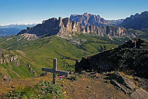
From the restaurant (cable car station) we hike along the ridge of Störes, with some small losses and gains of altitude we approach the N-NW ridge of Settsass. There the real No. 23 ascent starts. The well marked path starts crossing the slopes of Settsass, winding through rock chaoses and slowly gaining the altitude. It is obvious that we shall cross the SW slopes of Settsass quite high, and that must be paid with a scenic, but also a bit unpleasant ascent. Finally the altitude of some 2300 m is gained, the path crosses behind a strongly slanted rock tower and on the other side starts slightly descending towards the long grassy ridge, which connects Settsass and Col di Lana. We gain it on the altitude of 2253 m, near the wooden cross. From there we just descend gently southwards those 50 m to the Passo Sief, 2209 m. Altogether 2 h 30 min.
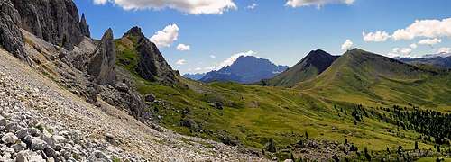 Crossing below Settsass
Above Passo Sief
2b. Valparola Pass - Passo Sief
From the Rifugio Valparola we go by the well marked path No. 23 towards the SW. First we pass above the lake, then go across some nice, wet meadows. The path keeps descending to avoid the E rocks of Settsass. By a steep, 10 m high rocky ravine (water stream) we descend more carefully, then the path goes further down in the woods, all the time crossing the slopes. Only on some 2000 m it again turns up, continuing to cross the slopes persistently. We need to cover quite some distance, the path goes over screes, rocky and forrested terrain, being all the time easy. Finally we reach the first alpine pastures, from there we still need to ascend some 100 m, until we reach the ridge, connecting Settsass and Col di Lana. We gain it on the altitude of 2253 m, near the wooden cross. From there we just descend gently southwards those 50 m to the Passo Sief, 2209 m. Altogether 2 h.
2c. Andraz Castle - Passo Sief
From the castle we can ascend the summit of Col di Lana also directly, or we can go westwards by cart roads and shepherds paths on broad pastures below Passo Sief. These paths are (I guess) not marked, but must be all the time easy. Also there's not much distance. To cover those 500 m some good 1 h 30 min are needed.
2d. Passo Sief - Col di Lana
The final ascent on Col di Lana from the north is the most difficult of all variants, but also the most beautiful one. Very nice scenes on the rugged ridge, all along the path remains from the Big War, wider and wider views around. On the Swiss Hiking Scale this part would be graded T3 (easy ferrata sections).

On the N ridge of Cima Sief
From Passo Sief we start ascending the N ridge of Cima Sief, first in turns, then all the time along war trenches. If curious, you can peek in a few caverns (battery!). The upper part of the ridge is steeper, but in normal summer conditions it's still not a difficult hike (in winter you ski down there). On Cima Sief the path turns down and gets a bit exposed. Short ferrata sections bring us down into the "crater", in the notch below Dent de Sief (ridge tower). Then an even steeper, but well protected ferrata takes us up on the top of tower, but on the other side we must unfortunately descend again. Normal, but steep slopes bring us down on 2383 m. There we first go through a gallery of a trench and then start the final ascent. Wooden stairs, accompanied by steel cable lead us up, then the path turns right up and in a nice ascent detours the very summit of Col di Lana. We reach first the memorial chapel and then the summit on the left. Good 1 h.
3. From Contrin
A marked path (No. 21) ascends on Cima Sief also from the west, from the hamlet of Contrin. In the upper part of the Federa valley there are also broad pastures, but the marked path catches already in the beginning the W ridge and goes along it on Cima Sief. That is also a ski route, so the ascent should not be difficult. 2 hours to Cima Sief, 30 more minutes on Col di Lana.
Mountain Huts
In the surroundings there are some private huts and restaurants along the roads, but the ascent on Col di Lana can be done as a good half day tour. When we were trekking there in August 2016, we found an wooden open hut just on the eastern side of the ridge, connecting Cima Sief and Settsass (below the wooden cross on 2253 m). Rather than picking up a tent, we slept in there.
Red Tape
No special restrictions.
When To Ascend?
| Col di Lana can be ascended any time of season. In winter conditions the ridge, connecting Cima Sief and Cold di Lana can be dangerous, so skiing is normally done only from Cima Sief. In summer conditions, do choose for ascent a day with good visibilty - to enjoy the panorama! | Click for weather forecast |