
-
 8466 Hits
-
 83.69% Score
-
 17 Votes
|
|
Route |
|---|---|
|
|
Hiking, Mountaineering, Trad Climbing |
|
|
Spring, Summer, Fall |
|
|
Most of a day |
|
|
V+ |
|
|
14 |
|
|
Overview
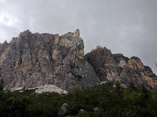
Col dei Bos - Spigolo Sud with marked belay stations
The route is pretty popular (we encountered two other parties on this route), and it brings you up to the summit of a beautiful Col Dei Bos with an amazing views of Cinque Torri group, Averau-Nuvolau group, and Tofana group.
The climb is located in the Fanes group, and new via ferrata al Col del Bos (= Ferrata Truppe Alpine) is located to the west of it (left). This is a relatively newly VF, built in 2007, and is described in Via Ferratas of the Italian Dolomites: vol 1., Cicerone Guide by John Smith.
![Climbing guide to the area]()
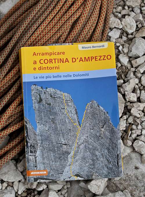
Climbing guide to the areaThe climb is described in several books of classic climbs in the Dolomites. We used "Arrampicate in Dolomiti" - a little book with nice topos and descriptions in both Italian and English and "Arrampicare Cortina D'Ampezzo e dintorni" by Mauro Bernardi - this book has nice photos, topos, and descriptions are only in Italian. We were fortunate and did not need to buy any of these guidebooks. Our hotel staff brought us so many informations when they found out that we are climbers, and they made copies of TOPOS of routes we wanted to climb.
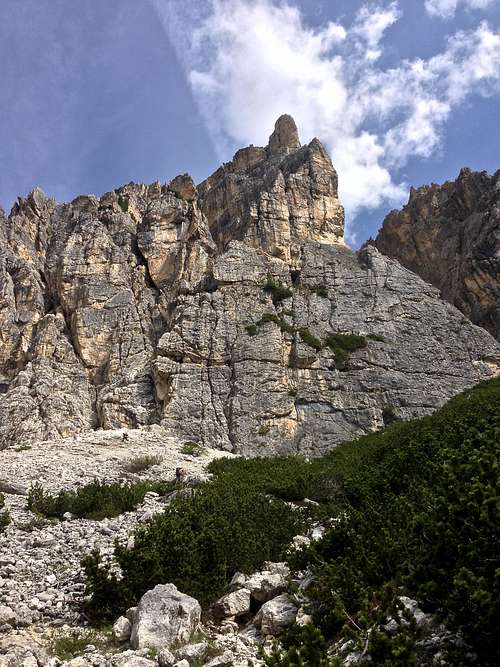
![Col dei Bos]()
Col dei Bos![Col dei Bos - Spigolo Sud]()
Col dei Bos - Spigolo Sud
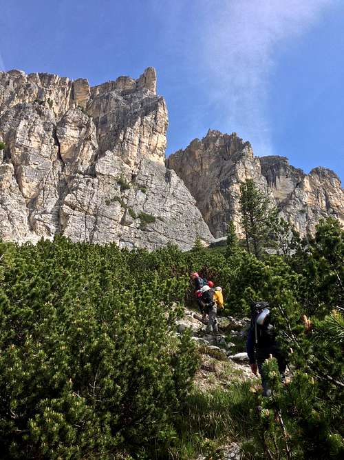
Take the road from Cortina towards Paseo Falzarego. Drive past the large parking lot with the chairlift service for Cinque Torri group, and in a turn (about one mile below the summit of Passeo Falzarego) is a parking lot with a building on the right side of the road. There is a marked start of the trail No. 412. Take this trail through the forest, nice and easy to follow. This will bring you to a larger trail and a concrete bridge. You can see Col dei Bos from this bridge.
Leave the trail No. 412 at the concrete bridge and walk up the scree filled gully. There is a faint trail, and expect some bush whacking through the vegetation. Allow 30 min for the walk in. You can see the climb from the concrete bridge.
The route was first climbed by S. Alvera and L. Menardi in 1947.
It is 400 meters long and the orientation is south (therefore possible to climb early in the season). The route is described in 14 pitches, some pitches can be combined together.
Climbing guide to the area
Area: Dolomiti
Group: Fanis
Cima (=summit): Col dei Bos
Getting There
Col dei Bos
Col dei Bos - Spigolo Sud
The best way to get there is to have a car, but there is also a bus service from Cortina. Paseo Falzarego tourist shop has a detailed schedule of the buses.
We had no difficulties in finding this climb although we are foreigners and new to the area. The climb is popular, expect to see some other parties approaching it.
The drive on the road from Cortina towards to Paseo Falzarego follows the road # 48, often Giro de Italia takes place here, and expect many cyclists on this tiny scenic winding road with a huge elevation gain.

Spigolo Sud TOPO
Route Description
Spigolo Sud TOPO
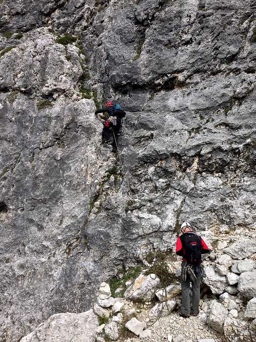
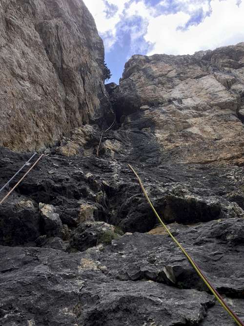
Pitch 1: Start more or less in the middle of the grey arete. There is a small cairn at the start of the route. The route follows up to a tree outcropping and there is a fixed ring right above the tree to belay from. Length 40 meters. Rated as IV.
Pitch 2: Climb pretty much straight up, very slightly to the left from the belay anchor. A little bit more steep than pitch 1, rates as 4/5, length 32 meters.
Pitch 3 and 4: we combined this together, these are easier pitches, length of 30 meters and 22 meters, rates as III to III+ for the pitch 4. Climbing goes pretty much straight up and stop at the fixed belay below the chimney.
Pitch 5: cross in the direction of the vertical chimney where the rock is very black, length 22 meters, rates as IV-V, 2 pins.
Pitch 6: enter the chimney that in some points requires passage through an overhanging rock (watch out your head) until exiting on a small shelf; then continue with stepping towards a fissure on the right side and exit the chimney. Protected with 4 pins + some gear needed. Length 23 metes, rates as V+. We combined pitch 5 and 6 together.
Pitch 7: continue up on an easier terrain, first section only I, higher up becomes III. Head up and slightly to the right. Anchor at fixed ring. 27 meters.
Pitch 8: proceed straight up past one fixed pin for 40 meters, rated as IV-. We combined again pitch 7 and 8 with some simul-climbing.
Pitch 9: this an easy and aesthetic pitch on the spine of the arete, scramble up for 30 meters to the next belay station, rated as III.
Pitch 10: continue up along the spine to the base of the steeper tower above, pause on the left side at a belay station. Length: 35 meters, rated as III. We combined pitch 9 and 10 with some simul-climbing.
Pitch 11: follow an easy path traversing to the left for 20 meters. Ignore the steep chimney above with a fixed cord. Rated as I.
Pitch 12: Head up and to the right, a few delicate moves, aim for a niche at the base of a chimney. There is a metal container there, which used to have per report a book of the route. We found the container empty. Rated as V initially, then IV, length 22 meters, protected with 2 pins.
Pitch 13: super short for a good reason, only 8 meters long, but passing through a very tight chimney, tight even for me at 54 kg. Bigger people have to move out to the left - almost out of the chimney onto a polished rock. It is protected with one pin. Rock is a little slippery at this section. This was the crux for me, and also rated as V+. When viewing this from the belay station (both below and above) it seems like there is no way one can fit through. My helmet got stuck in one direction and I could not turn my head, but when moved to the left I was able to free my head again.
Pitch 14: Follow the deep groove on an easy terrain, initially I, then III, slightly left until you exit on the summit of Col dei Bos. The views are amazing!
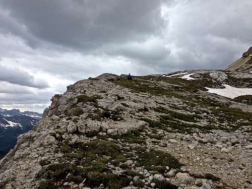
Descent: Walk off - walk rightwards down an old military path to the Col dei Bos saddle. There are some WWI ruins to explore along. The descent was easy to follow even in the snow conditions we encountered in June. The views of Tofana are amazing. Continue along dirt path, walk through the tunnel to a fork in the path and right below where you left the main trail to start access faint trail to your climb. Take path # 412 (well marked) down to your car.
Some climbing images
 Col dei Bos - Spigolo Sud start | 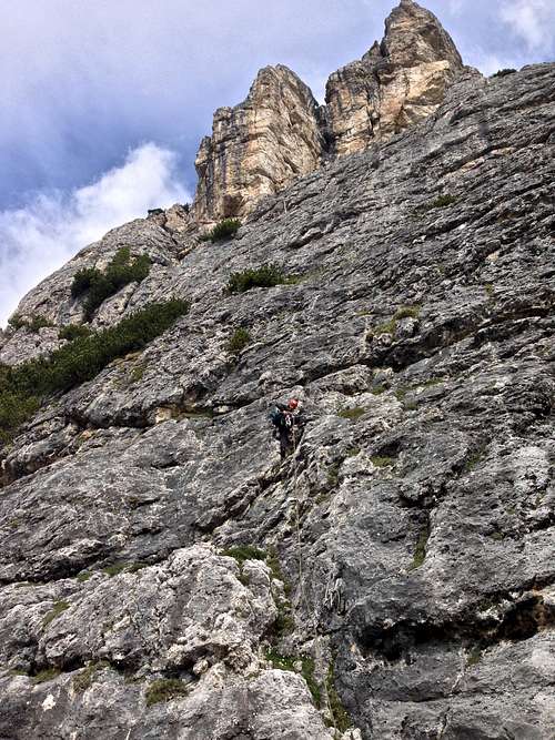 Col dei Bos - Spigolo Sud - 1st pitch | 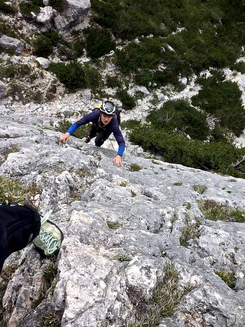 Col dei Bos - Spigolo Sud - 2nd pitch | 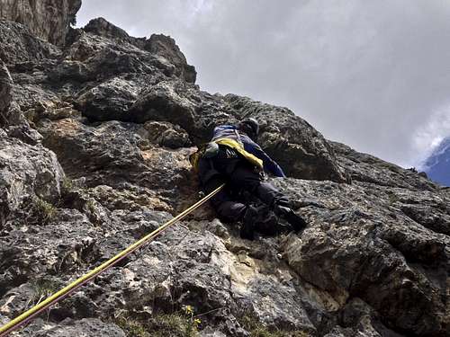 Col dei Bos - Spigolo Sud |
 Col dei Bos - Spigolo Sud | 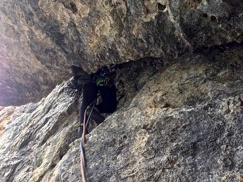 Col dei Bos - Spigolo Sud | 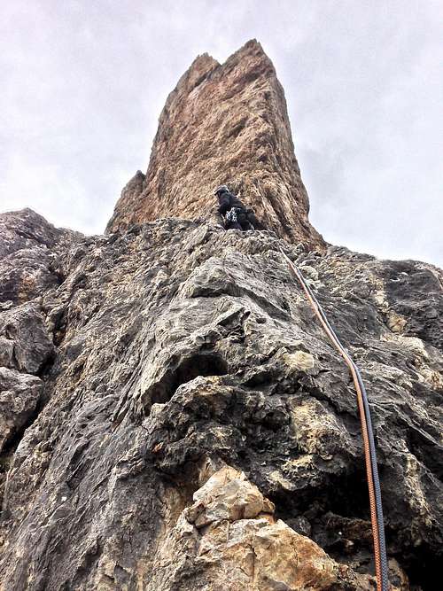 Col dei Bos - Spigolo Sud |  Col dei Bos - Spigolo Sud - the tight chimney crux |
I enjoyed the descent from Col dei Bos as much as the climb. The views and scenery are spectacular. Below some images from the summit of Col and the descent.
 Col dei Bos - Spigolo Sud Summit | 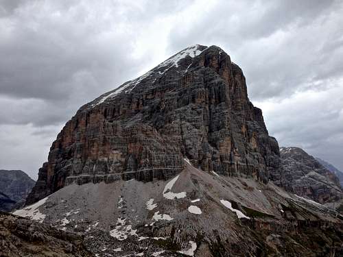 Tofana |
 Summit scene of Col dei Bos | 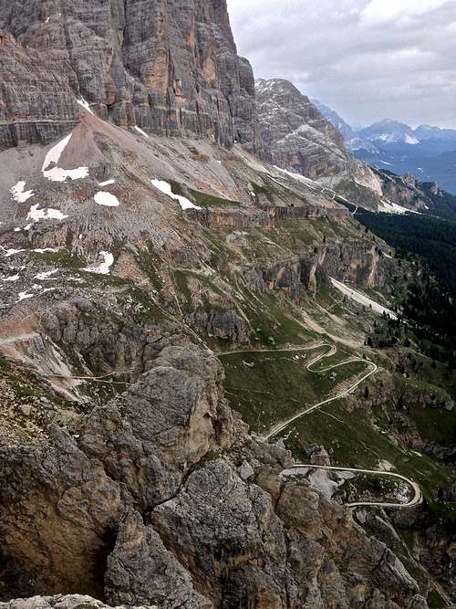 Descent on old military road |
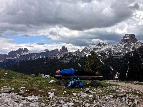 Rest on the descent | 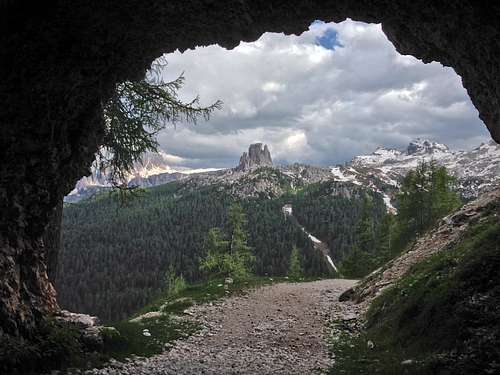 Cinque Torri |
Essential Gear
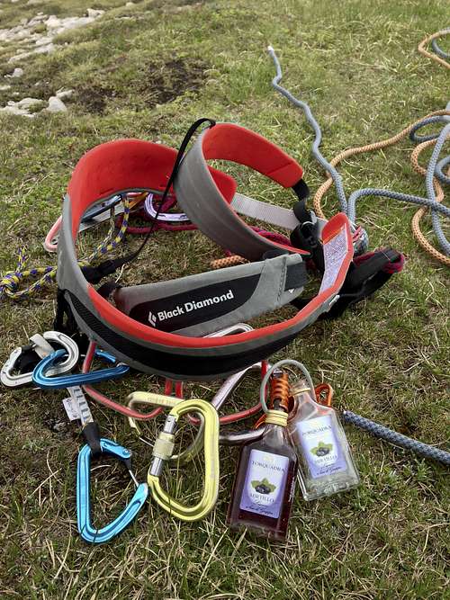
- Personal climbing gear: harness, rock shoes, belay device, helmet
- Ropes: we used two 60 meter ropes, but one rope would be sufficient (descent is a walk off)
- Gear: some fixed gear en route, e.g. slings through hourglass, pins/rings, and mostly trad gear (no big pieces needed), anchors are bolted (or better wording equipped with a ring).
- Little climbing backpack to carry your shoes, snack, water, jacket. (You can leave a big backpack at the start of the route, but you will have to return to get it on your descent, cca 20 min time. Or try to climb with all you have, squeezing through the chimney sections may require you to drag your backpack below you).
- Camera - the views from the summit of Col dei Bos are spectacular, and you can also explore WWI ruins on your descent.
Nice on-line description of the route - in Italian