A Trip to Climb some Peaks in the Olympics with Fay Pullen
Dates: Friday, August 13 to Wednesday, August 18, 2010
Ingress/Egress: North Fork Quinault River Trail
Weather: Superb (except for the last half-day hiking out)
Other: The Mt. Hopper Fire obscured our views on some days, generally in the south direction.
Mountains: Mt. Christie, Mt. Noyes, Mt. Meany, Pk 5448, Mt. Seattle
Dumpsters: Pk 2960+, Higley Peak, Macafee Hill
Day 1 – Drive Over and Hike the Long Long Trail
It was a 4-hour drive to the trailhead after picking up our permits at the ranger station. We set out hiking at 12:30pm. By 7:00pm we were all sixes and sevens as we tripped into camp at Twelvemile Shelter, which is actually only about 11.4 miles from the car. This campground got flooded out a few years ago. But plenty of flat spots can be found in the gravel bedding. We camped next to the old shelter, which now is merely an old roof.

Day 2 – Ford the River on a Tree, Hike up to Low Divide, Climb Mt. Christie
Sixteenmile Camp is only about 0.7 miles up the trail from Twelvemile yet it is called Sixteeenmile. This is odd. Someone we met on the trail said it was due to the trailhead being moved some years ago. I don’t know if I believe this. Anyway, a ford is usually required to get to Sixteenmile Camp on the other side of the river. But not this year (and maybe for a few years to come) because a big tree has fallen across the river. No more ford. At present a rough path through the brush leads to the gravel bar then over to the tree. But I expect in a few years the path will become “permanent” to the tree. The tree is difficult to get onto due to it size (until someone chops a notch in it) and it is hard to get off of (on the Sixteenmile side) due to a root ball, but a few sideways steps with good root holds gets one to dirt.


From the ford/tree, one encounters most of the uphill between the car and Low Divide (3600 ft). In the first 12 miles from the car, the trail gains only 1500 ft (and loses about half of that back in the ups and downs). The the last 4 miles the trail gains the remaining 1600 ft (but with less ups and downs to tax your legs and patience). All told, according to Fay’s altimeter, from trailhead to Low Divide, the trail gains 2100 feet but loses approximately 1000 ft. So it’s like 2100 + 1000 = 3100 vertical feet.

We made it to the deserted campground opposite the ranger station. I chose the best spot for our next three nights near to the bear wire, which was great for keeping big bear mitts off our food, but horrible for keeping little rodent paws at bay. They could simply tight-rope the bear wire up to our food. Bastard(s) got at my beef jerky, but I’m not allowed to harass these varmints.
At 12:30pm we headed out for
Mt. Christie (6177F, 1777P), despite the heat of the day. Our intended route to Christie was via Route 3 in the guidebook, even if it was vague as to which gully was the one leading up from the meadow. I guess the giant boulders will be obvious.
The Martins Lakes Trail starts out well enough for the first few hundred yards, but soon degrades to mud and brush and has streams running through it. Then at about 3900 ft the trail inexplicably goes through a v-shaped fault line instead of going up onto easier, wooded terrain to the left or right. Just above that at 4000 ft a little meadow is encountered. This is not the lower meadow mentioned in the guidebook. The
lower meadow is about a quarter-mile farther on and you descend into it. Sure enough, this meadow has gigantic boulders laying about in it. On the right (SW) is a broad “gully” (almost big enough to be a minor “drainage”).


We took this gully up mostly snow to a notch just west of Pt. 5895. From this notch we got our first view of Mt. Christie to our direct south. Wow! Nice looking mountain!

The north side of Christie harbors a healthy glacier (despite its size). The glacier has carved out a picturesque cirque and made the mountain a pleasure for the eyes.

We dropped left on easy terrain to reach the glacier and a water refill. I ate some power-up food just so I could keep up with Fay. You see, Fay skis all winter and spring, and I found it difficult to match her speed on the uphill snow slog. I blamed it on several other factors: that I was an out-of-shape dad now, that I had to make smaller steps to keep in her shorter strides (she is much shorter than me) and this expends more energy than my body is use to, and that I was stopping to take photos and look around. Do you buy those excuses? She’s only 28 years my senior. Come on!
Okay, so just before the obvious upper notch (not the obvious lower one) at the head of the glacier there is a suitable, but chossy ramp that leads up to the final crest. But we couldn’t get to it due to a paper-thin snow bridge and an improbable moat. So we had to go around the back side of the notch where we met up with a phalanx of crummy krummholz. I swear upon Alexander’s Macedonian grave that I hate this stuff. It always seems so hot and dusty when I have to auger through it and I generally come out with my hair and shirt full of needles.


After the initial krummholz the ridge got easier. There is one cool fin of rock near the top that one must climb up then down the other side (Class 3). The summit of Christie is a nice flat area. You could bivy up there and watch the sun set over the Pacific 40 miles away.

I think it took about four hours to make the climb up. The guidebook says four hours.
We descended the way we went up. The muddy trail seemed easier and faster on the way down. And the creek-stashed Dale’s Pale Ale felt easy on its way down too.
Views from Mt. Christie's summit:


Day 3 – Climb Mt. Meany by way of annoying Mt. Noyes
We set out from our Low Divide camp at 7:30am. Another Dale’s Pale Ale was stashed in a creek. In a couple of hours we made it to the basin at the head of Seattle Creek west of Mt. Seattle. This took longer than I anticipated. The Skyline Trail through here must be longer than I thought. Switchbacks not marked on the map add time and distance.
I saw my second bear of the season (the first one while on foot) in the basin. It’s funny. I was preparing to take a photograph of unnamed Pk 5428 across the valley when a black form wanders into view about 50 feet from my position. He looks at me and I look at him and he continues his saunter. Fay is catching up at this point and I tell her about our new hiking partner. But by this time the bear has wandered out of sight behind a knoll below me. When we move up trail a bit I thought we’d see him again for sure, but he was already gone. And I didn’t get a picture either. Drat!


In three hours we got to the 5500-ft col between “Cougar Mountain” (Pt. 5987) and
Mt. Noyes (6173F, 373P). There was even an old trail going to this col but we didn’t use it most of the time due to that crummy krummholz again.
We were next presented with a dilemma: descend the north side of the col then traverse over to the ridge leading to Mt. Meany, or go up and over Mt. Noyes. We didn’t like the idea of downclimbing steep snow in the morning (even if we had crampons) then traversing across steep scree to get to an access gully to climb up again. But Fay had already climbed Mt. Noyes in 1998 (though she couldn’t remember anything about the climb and so was unsure as we were standing there if she really had). I eventually convinced her that climbing over Mt. Noyes would be not much more elevation gain than doing the drop route. I further tantalized her by saying it looked like, based on map contours, that she might be able to bypass the final scramble by contouring the mountain’s NE side at 5800-6000 ft.
So we headed up Mt. Noyes from the col. Choss. All I will say is choss. Choss choss choss. And, no, the bypass was a by-golly no-way. So Fay climbed Mt. Noyes again. A rare repeat for her. There was no register at the summit. I told her not to leave one, that the mountain was too sucky-chossy to deserve one. We carried on.


 Some views from Mt. Noyes:


We wanted to run the ridge from Noyes to Meany. Shouldn’t be too hard. But I do see some gendarmes just below Noyes here.
Our first order of business was to get off Noyes. Just below the summit a steep snow finger/snowfield reached up the north ridge. I tried to descend around it on its western fringe because it was too steep to downclimb directly. Well the snow didn’t end, it just curled out of sight down a west-facing gully. I told Fay I might have to come back up to go around the snow’s east side by way of steep, unscarifiable dirt and gravel. But instead I opted to make a very short snow traverse of about 20 feet across 45-degree snow. Nice steps will be required here. If you fall, you die. There’s no self-arresting here.

After the steep snow we had to negotiate a series of gendarmes. Most of these were easy, though in need of concentration for every step and sometimes difficult to routefind. But one we agreed amounted to the death crux of the trip. One gendarme was too steep to downclimb off its north edge so we chose to descend its heathery west side to what looked like a heathery ramp. First of all, the heathery descent was super-steep. Second of all, the ramp wasn’t. It was really tiny ledges spaced in an awkward arrangement. One slip here and it’s down the hall you fall.
After descending using crummy little krummholz to green belay from, I sketched across the ledges and heather, grasping at flaky holds along the way, and ending with a jump into a scree-filling cleft. Fay, being shorter, didn’t like the jump and finger and toe climbed down. She said she was going to fall. But she didn’t. It was a tenuous moment.

After this gendarme, things got easier for the remaining ridge run over to
Mt. Meany (6695F, 1895P)—the pinnacled summit beckoning us over like a church steeple across town.
I looked back in the distance to the Noyes-Cougar col and what do I see? Mr. Bear is downclimbing the steep snow…without crampons! I point him out to Fay. This time she sees him.
A final snow slope leads up to a wide col just northeast of the summit. We scrambled up loose Class 3 ground to the final wall before the top. It looked harder than Class 3 (Olympics Class 3, mind you, which is really Class 4 by today’s standards).


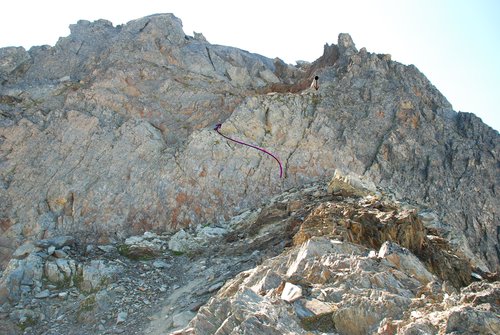
A short 20-ft wall rises up almost vertically. We chose to belay this with a 30m rope. But in the end it is probably free-climbable (at least in the up direction) due to fantastic
positive holds. I started up then moved left on a short ledge to a depression then up to a flatter slope. This flatter slope had a lot of loose rock on it so rockfall potential down onto Fay was significant. So I had her unhitch herself from below the wall and back up out of harm’s way. I set up a belay and brought Fay up.
The rest of the climb to the top is easier Class 3 on big, solid rocks, but there is one quasi-cheval spot. It was about 3:00pm when we summited.

We found a penciless register. The last entry was from Mike Torok and company in 2006.
Two views from Mt. Meany:


We rappelled the steep part and descended the ridge back to the gully we could have taken if we had not gone up and over Mt. Noyes. We first downclimbed the rib buttressing the north edge of the gully then got into the gully proper as its angle lessened.


We traversed over to the col, climbed up the snow to get to it, coming across the bear tracks as we did so, and then hiked down the other side to junction back up with the Skyline Trail in Seattle Creek. In 12 hours we were back to my Dale’s Pale Ale. And in 12 seconds Dale’s Pale Ale had vanished down my pale ale palate.


Day 4 – The Delabarre Delay and the Martins Lakes Grand Stand
Fay and I were a little worn out from all the climbing from the day before. We were on a lot of choss and a lot of trail. So we didn’t get an early start for Day 4. Fay wanted to check on doing Mt. Delabarre (6024F, 1144P), the next big peak southeast of Mt. Christie. To get to Delabarre would mean a long ridge run from the head of Martins Park. And it was going to be a hot day (it would seem like the hottest day of the trip).
We again found ourselves on the Martins Lakes Trail, but this time taking it all the way up to the head of the basin. The east side of Mt. Christie is massive. There is supposedly a glacier on this side but it looked like nothing more than a snowfield.
We climbed up to the 5000-ft col east of Christie to get a view of Delabarre in the distance. It sure was a long way over (about 2 miles) and we could see why
Jack Christiansen left it for last for his quest to do 100 peaks in the Olympics. The ridge run to Delabarre had at least two towers on it that would need to be climbed over or around. Given the probable technical difficulties, we decided we didn’t have the time or the commitment to go for it. So instead we puffed up to the unnamed prominence summit to east of the col (
Pk 5448, 448P).


We lounged and talked in the treed shade at the summit for an hour. I thought that “Wendy Peak” would make a nice
unofficial unofficial name for this summit since our mutual friend Martin’s wife’s name is Wendy.
Three views from Pk 5448:


But we couldn’t lie around on this peak forever. We had some standing around to do…
A short distance away (but annoying to get to on the sidehill traverse) are Martins Lakes. These are two picturesque lakes. The upper (northerly) lake was occupied by a bathing couple, so Fay and I returned to the lower lake (which is bigger than the map suggests) and took off our boots for a nice wade in the cool water. And we stood there in the water up to our thighs for an hour (I timed it!), our legs never getting chilled. We could have stood there all day. What better to do when you’re wasting time, waiting for the day to lazily drift by, like the lonely little cloud above, practically the only cloud we saw overhead all trip?


Back at camp and no more beer. I had only brought two. And Fay wouldn’t offer up any of the small bottle of Bailey’s she brought for herself. Wazzupwiththat?
Day 5 – Seattle, then Skedaddle
While Fay slept in I decided I might as well make a quick climb of
Mt. Seattle (6246F, 726P) since I live in Seattle. I left camp at 6:30am heading for the east basin route (Route 2 in the guidebook). The guide says four hours. Would it take me that long?
Instead of doing the option behind the ranger station, I chose the option of going up the east side of the creek. The lower 700 vertical feet was easy, open forest with hardly any brush, although the duff was slippery in the steeper spots. I began traversing at 4200 ft and saw a blaze on a tree. You know how it is when you see one and only one blaze. Is it a real blaze or just a chip out of the bark? In this case it was the former because beyond the blaze I followed an off again on again climber’s trail. The trail haphazardly crossed a ravine just before dumping out into an ankle-brush-infested scree slope. From there the trail continues up the east side of the creek to the basin at 4600 ft. Don’t be tempted to take the trail junction going west that crosses the creek at about 4500 ft. That trail leads over to a waterfall then commences to wander back then forth without gaining anything but your ire.
From the basin I headed up the broad rib left of the headwall to get up to the high interconnected snowfields. For the most part I stayed far to the left and angled up to the summit crest. At the crest I turned left toward the main (SW) summit, in the process crossing a short knife-edge of snow dropping to either side of the mountain. That definitely got my attention.


The summit is an interesting jumble of upward-pointed elongated rocks. A brief, but easy Class 4 stem move got me between the rocks and I was up...2.5 hours after leaving the tent.
Some views from Mt. Seattle:


Even with a half-hour break, I was back at camp in 4.5 hours round trip. The interconnected snowfields were great for making a quick plunge-stepping descent.
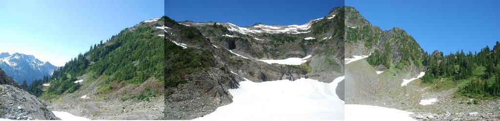
A panorama of the east basin (approximately 170 degrees of pan):
This was a fun climb and a fun route. A climb up from the Seattle Creek, while doable, didn’t look as fun.
~~~~~~~~~~~~~~~~~~~~~~~~~~~~~~~~~~~~~~~~~~~~~~~~~~~~~~~~~~~~~~~~~~~~~~~~~
At about noon we headed out down the trail, hoping to get as far as Elip Creek for the night. We got there and then some, finishing 11 miles to Halfway House Camp in about six hours.
Day 6 – Higley Macafee was a Dumpster Divin’ Son-of-a-Peakbagger Gun
With only five miles of trail remaining to the car, we were out by 10:00am. This left some time to tag our peakbaggin’ graffiti on some dumpsters in the area. And since Fay and I are two of the activity’s most stridently ardent garbage collectors, how could we not?
I had my eye on two dumpster summits in general and others if time permitted.
Pk 2960+ (440P) is on the Finley Creek Quad. And now it is on Fay’s and my climbing logs. We took Prairie Creek Road off of Hwy 101, took a right at the junctions, and soon found ourselves below this dumpster. We climbed up its sides and on into its summit. Trashy. And not so classy. This was not one of the summits I originally had my eye on but since we missed the one I did have my eye on on the way by…
Higley Peak (3000+F, 1200P) was the one I had my eye on. I just love the name Higley. Imagine if I had named my kid Higley! Higley Klenke! Anyway, this peak straddles the national park boundary and there is a short trail up to the top. Maybe that’s why we came upon a broken down trailhead register there. People had even signed in as recently as 2009 before the paper ran out and got waterlogged.

We ambled up the enjoyable trail as it coiled around the mountain about two times. In about 15 minutes we were on top. And by top I mean a small, domal clearing in the woods where two old lookout foundations, one concentric within the other, sit silent in the ground like melancholy tree stumps. There’s nothing else there, and certainly no views. No matter, the foggy coastal clouds would have obscured them anyway.
Macafee Hill (665F, 295P) is such a prominent hill, it even has a quad named after it. Okay, well, it may not be high, but it is the only thing out in the vast logging flat near the Copalis River west of Hwy 101. But although it is the only hill out there, you can’t even see it until you’re practically on it.
We drove in from the NE but this isn’t the shortest way. Here’s the shortest way for the maybe half a half-dozen of you who would care to do this hill (you know who you are):
About 1.5 miles north of Humptulips just after the road turns northward at a bend, find a logging road on the left. This road connects to the old railroad grade in Section 4. This grade is the 8000 Road, I believe. At the road wye in Section 34 go left. At the first road wye in Section 33 go right. Take this road north past the 361’ wye to the next wye (just past 365’ junction) in Section 20. Go left (west) and drive for a while to where the road bends left (south) at the north end of Macafee Hill. The road goes past the east side of the hill. At about 1.3 miles down from where the road bent left, find the road leading up to the top. Distance is 9.3 miles from Hwy 101 to summit.
The true summit (survey marker in the trees) is up a spur off the summit road. The survey marker is in the trees at left. Look for ribbons tied to trees and an orange post and the ghosts of two stupid idiots past...


Comments
Post a Comment