
|
|
Route |
|---|---|
|
|
40.26090°N / 105.611°W |
|
|
Hiking |
|
|
Summer |
|
|
Less than two hours |
|
|
Class 2+ |
|
|
Overview
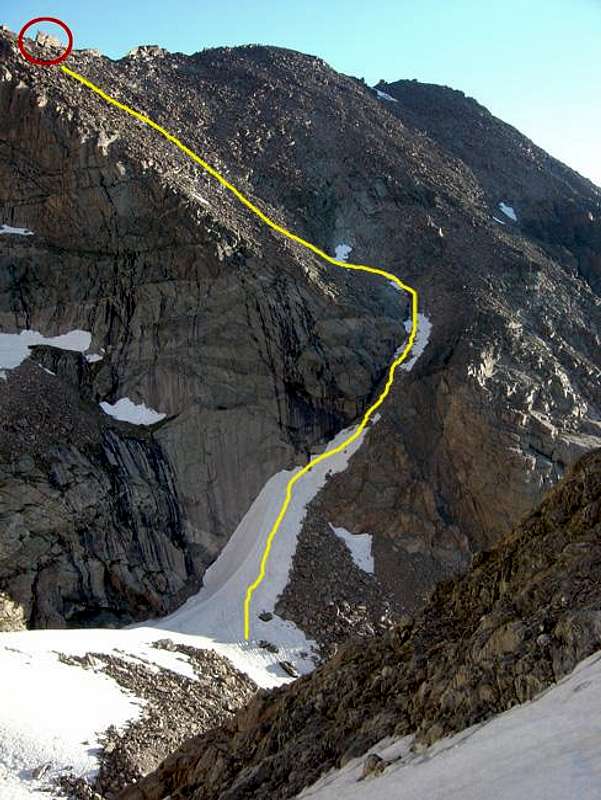
Photo by Andy.
Camel's Gully is a long gully that leads from near the Long's Peak/Mt. Lady Washington saddle to just below Mills Glacier above Chasm Lake. It is a long gully (about 1,200 feet) and is primarily used as a descent route for climbers having just finished technical routes on Long's Peak returning to their bivy sites. It is easily found from above and below by its characteristic "camel" rock formation at the top of the gully.
I don't see the point in using this gully unless absolutely necessary. It will be much shorter distance-wise than dropping to the Boulderfield and hiking back around to Chasm Lake, but time-wise, it's a toss up. It is a loose, scree filled mess in the middle and lower sections. The upper section is solid, but slow boulder-hopping progress is to be expected. Use caution if you are above other climbers as it takes little effort to send large rocks tumbling down the length of the gully.
Getting There
To get to the top of Camel's GullyIf you are descending the North Face of Long's Peak, just follow the ridge-line down to the Longs/Lady Washington saddle. As you hike along this ridge you will have incredible views into the gorge below and of the Diamond and other East Face routes of Long's. You will have to climb back up Lady Washington a hundred vertical feet or so to the Camel rock formation. It is easily recognizable. Here is where you begin your descent.
To get to the base of Camel's Gully
The base of the gully is gained just above Chasm Lake. Hike to Chasm Lake and scramble around the North side of the lake. There is a faint climbers trail that will lead you beyond and into the upper gorge. Stay to climbers right of the gorge and you will see the gully leading up and to the east just before the huge northern head-wall of this gorge.
Route Description
DescendingOnce at the camel rock formation at the top of the gully, you will begin decending over easy class 2 boulders. As you descend stay more to skiers left so you don't cliff out. But don't go too far left or you will get into some nasty 3rd/4th class downclimbing. It would be better to drop vertically and cliff out, having to traverse along the top of the cliff, than to head too far to the left and have to down climb the steeper terrain. But if you get the right angle, which was hard to judge from above, you should have no trouble. The upper section will naturally filter you down to the scree/sand filled mid/lower sections. Just pick the best lines down this slope and you will, not soon enough, be at the base of the gully.
Ascending
Pick the best line up the sandy/scree filled lower section of the gully. There will be some larger cliffs to your left. Once you get above these cliffs, you will be able to see the best line up the upper section of the gully. You will head to the left and head for the camel rock formation above you. Coming up the gully should be more straightforward, however, I don't know why you would ever want to climb this thing.