
-
 7264 Hits
-
 85.36% Score
-
 20 Votes
|
|
Mountain/Rock |
|---|---|
|
|
45.94077°N / 7.74723°E |
|
|
Mountaineering, Ice Climbing, Mixed, Skiing |
|
|
Spring, Summer |
|
|
13665 ft / 4165 m |
|
|
Overview
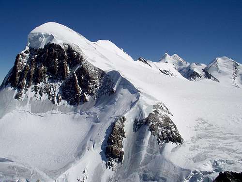
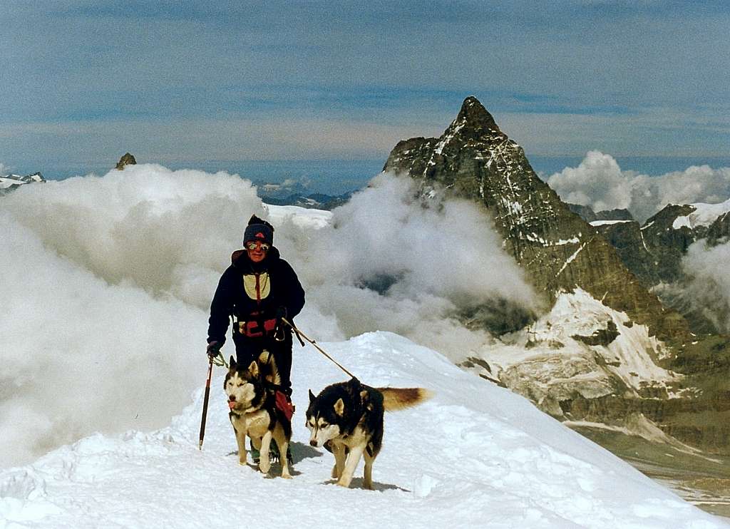
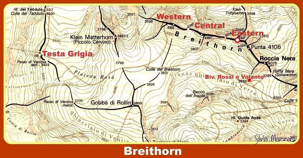
Breithorn Occidentale (Western Breithorn)
The Breithorn Occidentale - Western Breithorn 4165 m is an ice-capped mountain belonging to the Monte Rosa Group in the Pennine Alps. It is the culmination of the long Breithorn chain and the Westernmost peak among the five ones that form the chain. It is located along the border line between Italy (Aosta Valley) and Switzerland (Valais Canton) and it is separated from the Breithorn Centrale by the Sella 4081 m.
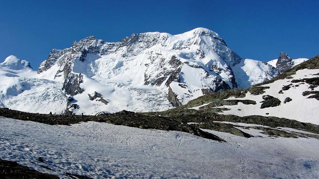
The Western Breithorn is simply called "Breithorn", being by far the best known and most frequently climbed amongst the three Breithorn and also one of the easiest Four thousand to climb in the Alps. Breithorn Centrale and Breithorn Orientale are less frequented and also slightly lower. See here the complete full list of the 82 Fourthousanders of the Alps: Club4000.
From the Italian side it looks like a short and rather slope covered by snow; from the Swiss side, on the other hand, it appears as a steep and very high wall of ice and rock. If it were not for the Klein Matterhorn cable car on the Swiss side, which whisks climbers and skiers up to over 3800 meters, and the Cervinia-Plateau Rosà cable car on the Italian side, which whisks people up to 3480 meters, Breithorn Occidentale would be a long climb by any route.
The existence of these facilities and the presence of a fairly easy Normal route makes it possible to climb this mountain in one day without overnight stay, however it is not an advisable option for altitude problems. It is still a Four thousand, although easy! The Western Breithorn is considered an easy 4000, but even if from a technical point of view this ascent does not involve particular difficulties it is always an ascent in a high mountain environment.
The first ascent of Western Breithorn was accomplished on August 13, 1813 by Henry Maynard, Joseph-Marie Couttet, Jean Gras, Jean-Baptiste Hérin and Jean-Jacques Hérin.
Getting There
The best starting point are Breuil-Cervinia (Valtournenche Valley, Italian side) or Zermatt (Swiss side).
Getting to Breuil-Cervinia. Breuil-Cervinia is situated at the end of the Valtournenche Valley.
- From Turin and Milan: follow the A5 Motorway and exit at Chatillon (Aosta East). Follow the road 406 rising along the Valtournenche Valley, reaching Antey Saint André, Valtournenche and finally Breuil-Cervinia m. 2006 (27 km. from Chatillon). A cable-car station is situated downtown and reaches Plan Maison m. 2548 and Testa Grigia m. 3480 on Plateau Rosà. - From France: you can reach Aosta through Mont Blanc Tunnel or Little St. Bernard Pass. - From Switzerland: you can reach Aosta through the Great St.Bernard Tunnel or the Great St.Bernard Col.
Getting to Zermatt
Zermatt is situated at the end of Mattertal on the Swiss side. Cars are not allowed in the town. Motorists can drive as far as Täsch, from where trains (shuttle trains run every 20 minutes) and minibus taxi operate a shuttle service to Zermatt. Little Matterhorn Cable-car transports climbers to the upper station at 3820 m. (no overnight stay possibility).
Routes
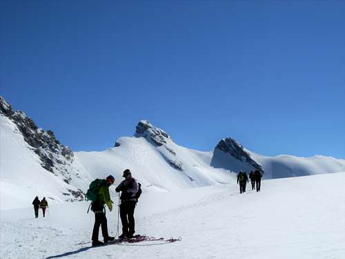
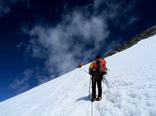
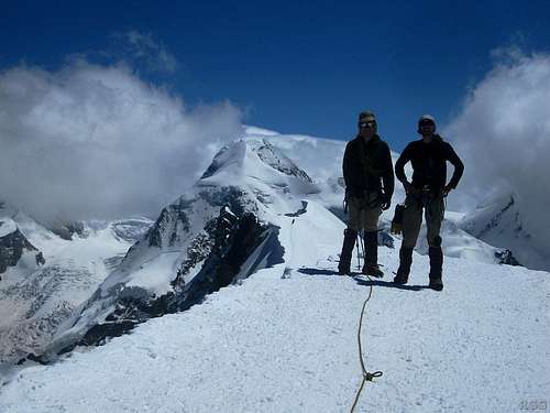
Breithorn Normal Route - The normal route on Breithorn Occidentale, running on the SSW Flank, is one of the easiest routes on a 4000 meter peak in the Alps, pleasant climb on 35 degree snow or ice graded Facile (F). It is accessible both from the Italian side and the Swiss side by cable car. It affords incredible views. Due to these facts the normal route on Breithorn is one of the most attended of all 4000 meter peaks.
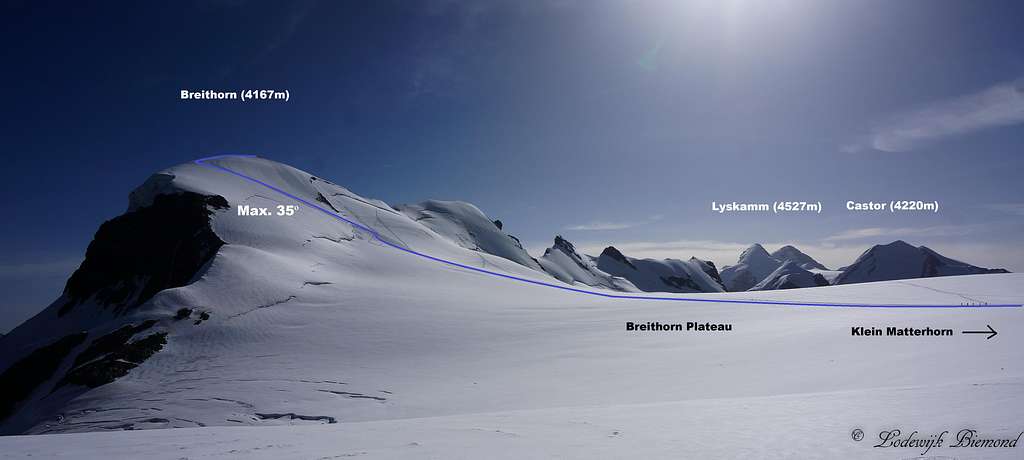
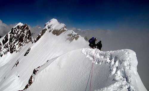
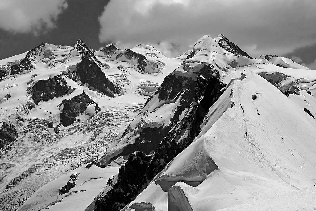
Breithorn Traverse - The crossing of the Breithorn is a profitable ride at high altitude that allows climbing 5 peaks over 4000 meters: Roccia Nera / Schwarzfluh, Gemelli del Breithorn (Breithornzwillingen), Breithorn Orientale, Breithorn Centrale and Breithorn Occidentale. It is one of the most fine and classic ascents in the Monte Rosa Group, with a varied course of over 2 km between fun rock sections and aesthetic snow ridges. There are two possibilities to realize the traverse : direction W-E and the opposite, direction E-W.
The north face of Western Breithorn - about 1000 meters high - is completely different from the South side of the mountain and by contrast is rather impressing. The Triftjigrat is the North ridge of Western Breithorn. It's a classic (old style) route. Not to be underestimated even if not difficult : you reach 4000 m and the descent can be very dangerous with fog. Starting hour should be very early (2-3 o'clock) - the climbs require 4-5 hours - about 1000 m drop. The ascent is rated AD like Matterhorn. The best starting point is Gandegg hutte 3029 m. Another starting point could be the Capanna del Teodulo 3317 m but you have to descend till almost the Gandegg in full night.
Red Tape
No particulary restrictions in climbing.
Huts
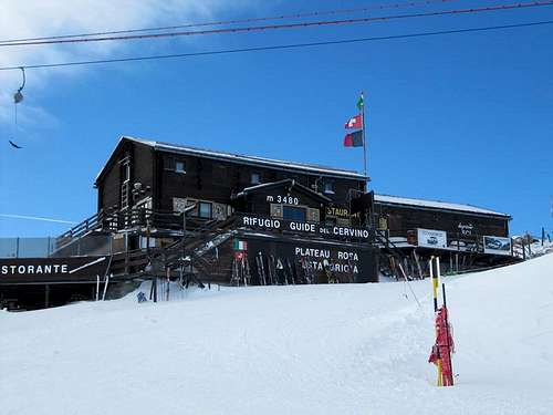
- Rifugio Guide del Cervino 3480 m (Testa Grigia) Breuil-Cervinia upper Cable car station
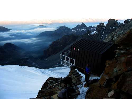
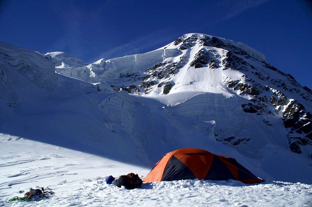
- Bivacco Rossi e Volante 3750 m
Situation: Verra Glacier near Porta Nera
Opening: permanent
Owner: Club Alpino Italiano Sez. Torino
Size: 10 persons
Access: From the Rifugio Guide Valle d'Ayas to Lambronecca with about 1.30-2 hours on the glacier (difficulty F)- required rope, ice ax and crampons
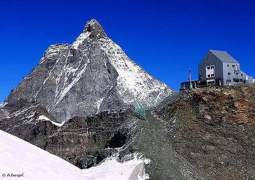
Situation: above Theodulgletscher and Theoduljoch just some meters on Italian ground; 45°56′39″N 7°42′30″E Valtournenche Valle d'Aosta
Owner: CAI sezione di Torino
Open: all year round
Size: 86 persons
Winter shelter: hut is open in winter
Phone: 0039-0166-949400
Rifugio Teodulo is situated about 1 hour above Gandegghütte. If you approach the hut from the Swiss side follow the route to Gandegghütte. Climb the rock ridge / middle moraine south of Gandegghütte and follow the ridge and right / west of it until you reach the Theodulgletscher. Follow Gandegg ski lift track until you arrive below Theodul col. Go right and ascend steeply to the col. Some more steps bring you up to Rifugio Teodulo.
The approach from the italian side starts at Breuil-Cervinia and uses the cable cars os the trails and mountain roads via Plan Maison to Colle Teodulo and the mountain hut.
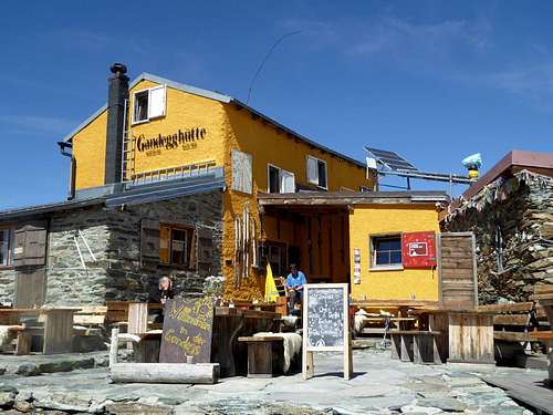
Gandegg Hut 3030 m
Situation: below Theodulgletscher
Owner: private: Richi & Yvette Lehner-Gaudin
Open: all year round
Size: 45 persons
Winter shelter: hut is open in winter
Phone: 0041-(0)79-607 88 68
Access: From Zermatt railway station follow Bahnhofstraße and Oberdorfstraße to the cable car station Zermatt – Furi. Stay right and follow the trail, direction Zmutt (signposts for Gandegghütte) until you can cross the Zmutt creek on a foot bridge left of that trail (again signposts Gandegghütte). Ascend to the Alp village “Zum See” and to “Hermetji". After Hermetji inn a trail branches off to the left in the direction to Furgg. Cross the ski run below Furgg and follow the trail, marked again Gandegghütte. Beautiful view of Matterhorn. The trail climbs the moderate grade slopes up to cable car station Trockener Steg. At a trail junction go straight on (to the right you will reach Trockener Steg), pass by a small lake and arrive at Gandegghütte
Accomodation
Several possibilities of accomodation in the various village of the Valtournenche
When to climb
Mountaineering: from June to September
Ski-mountaineering: from March to May
Meteo
Meteo Regione Valle d'Aosta
Meteo Switzerland
Meteo Cervinia
Meteo Zermatt
Guidebooks and maps
Guidebooks


 Guidebook")
"Il grande libro dei 4000" by Marco Romelli, Valentino Cividini - Idea Montagna Editore, 2015
“Monte Rosa” by Gino Buscaini (Club Alpino Accademico Italiano) – Collana Guide dei Monti d'Italia CAI-TCI (Club Alpino Italiano-Touring Club Italiano)
“Tutti i 4000” – L’aria sottile dell’alta quota” – CLUB 4000 CAI TORINO – Vivalda Editori
“The 4000 of the Alps” by Richard Goedeke (CAAI) – All the normal routes to the 4000m. summits of the Alps – Libris Edition
"Le Alpi Pennine, le 100 più belle ascensioni fra il Gran San Bernardo e il Sempione” by Michel Vaucher - Zanichelli Editore“
“I Quattromila delle Alpi” by Karl Blodig and Helmut Dumler – Zanichelli Editore
“100 scalate su ghiaccio e misto” by Walter Pause – Gorlich Editore
"Hochtouren im Wallis - Vom Trient zum Nufenenpass" by Hermann Biner 2nd ed. 1996
"Viertausender der Alpen" by Helmut Dumler and Willi P. Burkhardt 11th ed. Munich 1998
"Walliser Alpen. DAV-Gebietsführer" by Michael Waeber 12th ed. Munich 1999
"Valliser Alpen. Die 100 schönsten Touren" by Michel Vaucher 2nd ed. Munich 1990
Maps

"Breuil/Cervinia-Zermatt" Kompass map 1:50.000
"Cervino-Matterhorn e Monte Rosa" n. 5 - Istituto Geografico Centrale map 1:50.000
Schweizer Landeskarten:
"Zermatt" n. 1348 1:25000
"Matterhorn-Mischabel" n. 5006 1:50000
"Mischabel" n. 284 1:50000
"Gressoney" n. 294 1:50000
External links
Breithorn at www.4000er.de
Images, routes, coordinates and more information about the highest peaks of the Alps Photo Breithorn from Gornergrat