|
|
Route |
|---|---|
|
|
44.05400°N / 16.48750°E |
|
|
Hike |
|
|
Most of a day |
|
|
Walk-up |
|
|
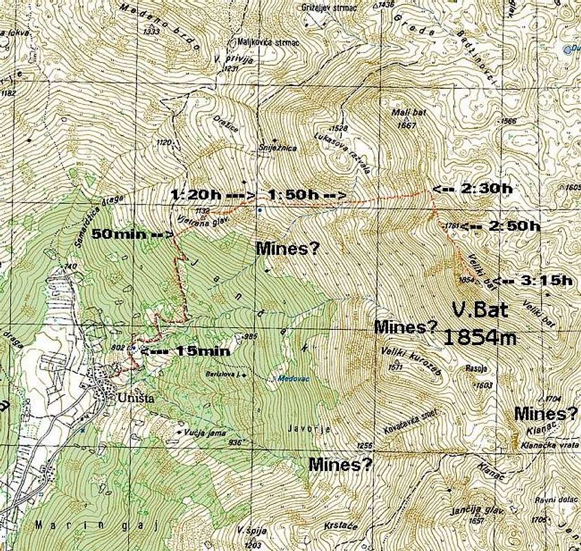
Getting To Unista
In the Kijevo road towards Unista branches. Junction is marked. Since Kijevo is long orientation where junction is is church on the hill. How to reach Kijevo is described in ‘Getting There’ section on the main page. Few hundred meters from the junction, on the shoulder of the hill on which the church stands, beautiful view opens towards Dinara (1830m), highest Croatian peak, also towards our goal; Bat (1854m). Few bands take you down onto a huge plateau in the upper Cetina river valley. Over the plateau it is some 7km to the Glavas village, trailhead for SE Dinara approach. Road continues to gradually ascend. Bat is in front of you all the time and huge open slopes trick your eye and make it seam it is close and that you’ll be up there in no time. Some 12km from Kijevo, at the beginning of Unista field, is border crossing between Croatia and Bosnia. Border is open and there is no checking of documents. From here beautiful view of Unista and Bat opens. You can notice a passage through the forest above the village which ascends towards left. You’ll use it till you leave the forest behind and then turn right towards Bat. On the first junction down on the field take left road. After short ascent you’ll find yourself on a wider plateau in the center of the village, park here.
Route
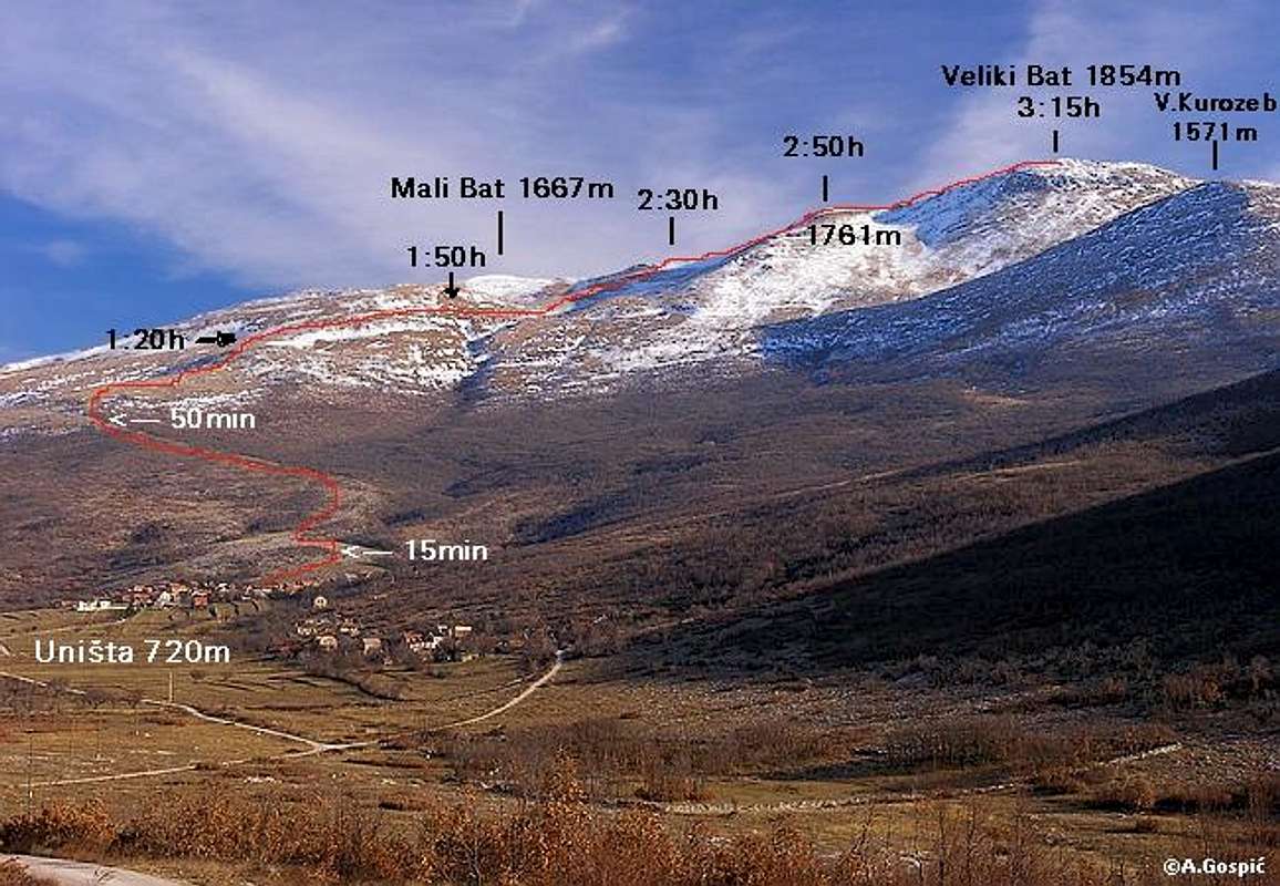
Unista – Bat: 3.15h
Take the street between the tree and the house whose lower part is painted in white. Soon street turns right and you are leaving the village behind. Continue over the open rocky/grassy slope and by the rocky wall which is one the left. Above the wall, on the left, is plateau where church used to stand. It’s been blown up in the war so scattered rocks are now on the plateau. Continue straight. Here you will notice broad rocky track which is wide as road. This track is connecting Unista with Bosnian side of the mountain and further Bosansko Grahovo town. It goes through that passage in the forest. But we are not there yet.
15mins above the village is plateau with large rounded well Spija. Above the well track continues up the grassy/rocky slope. When it reaches the oak forests it continues to gain altitude in several bends before it will turn left into that mentioned passage. Some 50mins above Unista you’ll reach upper edge of the forest and it is time to turn right and straight up the mountain.
Through the rare oak trees and over the steep grassy slope continue up. After 15min you’ll pass right by the edge of a small basin with meadows. Now continue up following the steep rocky ridge. In 15mins you are on the small plateau, 1.20h from Unista.
From here you’ll notice that it is time to go right towards Bat. It is best to do it above the horizontal belt of rocks/cliffs. Head straight, in the same direction, using the ridge left of larger terrace, which is on the right. After you reach a well visible lonely tree turn right and continue gradually gaining altitude. After 30mins you’ll be at the top of the steep torrent canal that descends towards Unista and at the bottom of amphitheater like grassy/rocky slope. Right above is nameless head 1761m. Your goal is pass on the ridge, left of that head and right of Mali Bat (1667m).
Although it seams quite close there is over 200 vertical meters to the ridge/pass and you’ll be there in 40mins. Already wide southern panorama is extended with northern view from the pass. Below is vast undulating plateau.
From the pass turn right and up the steep slope you’ll reach the summit of the nameless head 1761m in 20mins. From here fantastic view opens on all side. In front is our goal; the real and large summit of Bat.
From the head there is short descent to the pass between it and Bat. Over the narrow and steep summit ridge you’ll reach the summit in another 25mins, 3.15h from Unista.
Map