
|
|
Mountain/Rock |
|---|---|
|
|
45.78780°N / 123.9203°W |
|
|
Clatsop |
|
|
Hiking, Scrambling |
|
|
Spring, Summer, Fall, Winter |
|
|
2682 ft / 817 m |
|
|
Overview
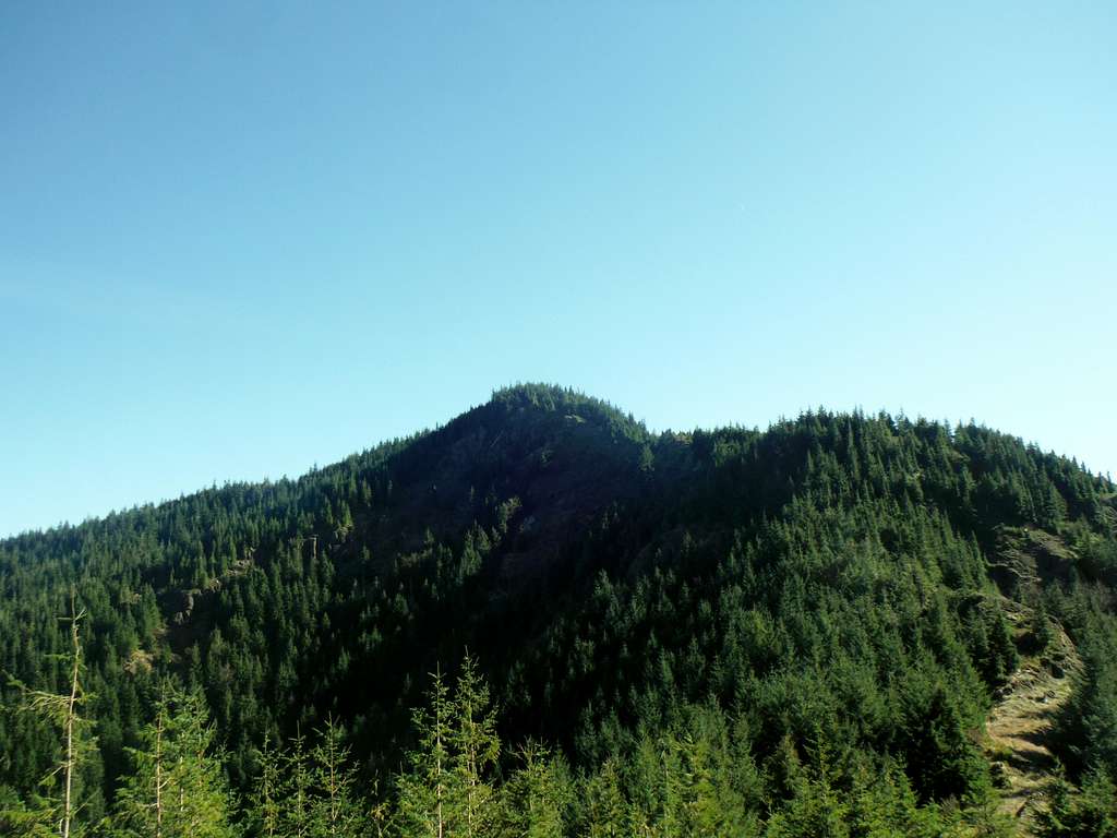
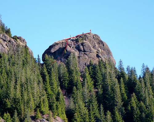
Looking up the Angora Peak Ridgeline
Angora Peak located just southeast of Cannon Beach is a little known summit south of Cannon Beach. Due to the fact that the land that Angora Peak is located on is private logging, (Stimson Logging) this mountain does not receive much in the way of popularity, except from local hikers in the region. This despite the fact that Angora Peak has 1022 feet of prominence which is quiet large for this region. Many of these local hikers often though go up the peak in a regular basis because despite the lack of information or attention that is peak gets over the web there is a well beaten path much of the way up to the summit which follow former logging roads off and on to the final summit bushwhack.
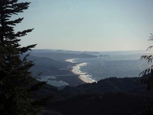 Stunning Pacific Ocean Views from the south side of the Jeep Path. | 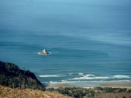 Looking down at the Pacific Ocean |
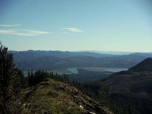
Though this peak is only a little over 2600 feet in elevation the hike up to Angora Peak is home to excellent views of the Oregon Coast, the Coast Range and on a clear day Mount Rainier, Adams, Hood and Saint Helens. The absolute true summit of Angora Peak is completely treed though there are some views that break out if you scramble down to your south side to a ledge. There is also a nearby ledge 200 yards to the east that is nearly the same height as the true summit. This viewpoint provide excellent views towards the south and west. Often this is mistaken for the true summit, which seems more wishful thinking. When I was here I was able to see Mount Rainier, Adams, Hood, and Saint Helens as well as Onion Peak and the Coast Range. I would spend time here once you have already tackled the true fully treed summit.
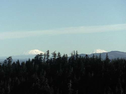 A look at two of the volcanos | 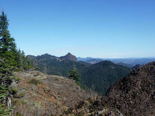 Onion Peak from the eastern sub-summit |
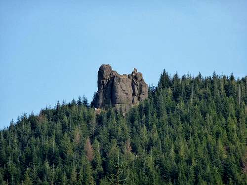
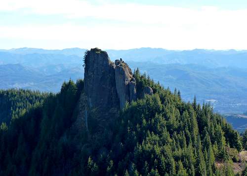
Finally several hundred yards away lies a rock outcrop that rises to within ten feet elevation of being the high-point on Angora Peak. It is called Revenge of Angora and from data I was able to get it is supposed to be a Class 3 scramble. This looks to have an excellent view on the entire area and is worthy of a separate SummitPost Page in its own right. Hopefully in the near future I will be able to get here to explore more views from this rock outcrop.
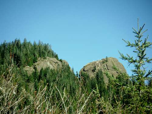 Angora Peak and Revenge of Angora | 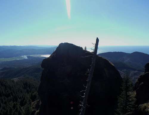 Revenge of Angora |
Getting There
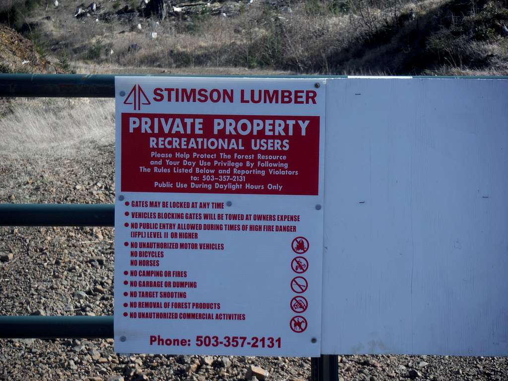
The Gate to the Gravel Road leading to Angora Peak is located just 300 feet south of Falcon Cove Road on Route 101. This is roughly 3 miles south of Arcadia Beach Park and 2 miles north of the Cape Falcon Trailhead. You will see the sign below to mark the gate.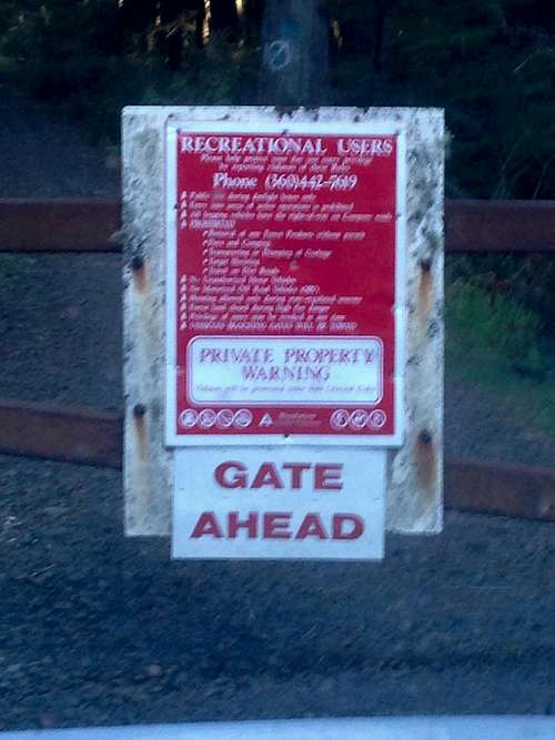
Trailhead Gate Sign
Route
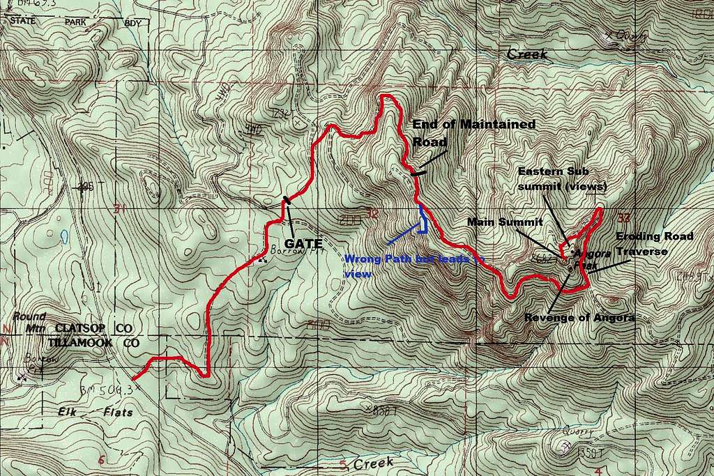
Trail Map to Angora Peak
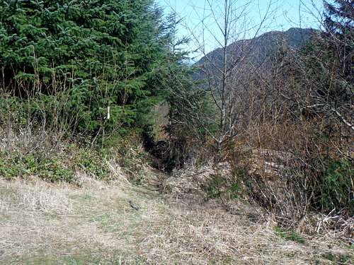 Keep your eyes open to flagging | 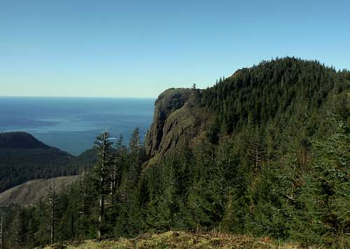 The western sub-peak |
This is the point where you have to pay close attention because 100 feet from where you pick up the road you then run into a marked path on your left hand side. Take the path to your left and don't continue up the road. Stay on the path as it at time fades in and out while traverse the north side of the ridge. You will in roughly 1/3 of mile enter into a gap between the ridge and main peak area. The road here will be in much better condition for the next 3/4 of mile as it traverses along the south side of Angora Peak. Great views off to the south will dominate this section of the trip up. Take this all the way to where you will run into another gap. This gap will be between Angora Peak and a needle like summit called Angora Pinnacle.
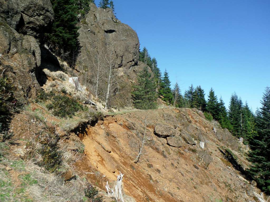
Rapidly disappearing route up Angora Peak
At this gap make a left and head north. This road is rapidly eroding in places and in 5-10 years it make not be very doable. Right now in sections this former road has become more of a catwalk so use a little caution here. Take this roughly a quarter mile to an open field. You will see another this time overgrown road off to your left heading south. This road is now has more vegetation on it then many of the other roads but is still navigable. Take this road all the way to the point that road make almost a U turn. At that bend find a good place either at the small creek or where there are markings. From there bushwhack up to the top. If you hit an excellent view outcrop you are not on the summit but you are enjoying excellent views. If you hitting a treed area you have hit the summit you will have to scramble a bit for some views.
 Stunning views | 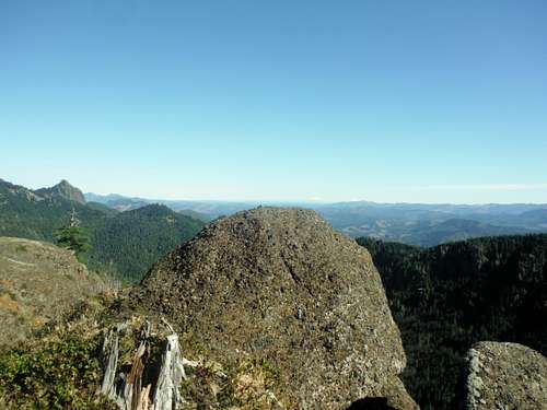 Looking over the eastern ledges! |
Other summits and sub-peaks that combined with the summit of Angora Peak within a day
SPECIAL THANKS TO KARL HELSER AND BRIAN JENKINS FOR THE INFORMATION ON THESE THREE SCRAMBLES. ALL PICTURES IN THIS SECTION WERE TAKEN BY EITHER KARL HELSER OR BRIAN JENKINS.
1. Little Angora
A mile to the north of Angora Peak is Little Angora which is a dramatic rock outcrop. This rock outcrop is a technical rock climb featuring mid 5th class moves and critical jump within in the line. Technical gear is a must for Little Angora. (Special thanks to Karl Helser)
 Little Angora | 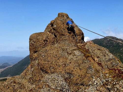 Technical move on Little Angora |
2. Revenge of Angora
This thrashy 3rd class comes within feet of being the highest point in the range. No technical gear needed provided you find the right route.
 The route up Revenge of Angora | 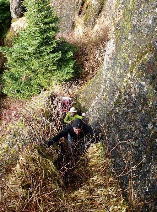 Scrambling up Revenge of Angora |
3. Angora Pinnacle
Another 3rd class thrashy scramble that is a half mile to the east of Angora Peak.
 Angora Pinnacle | 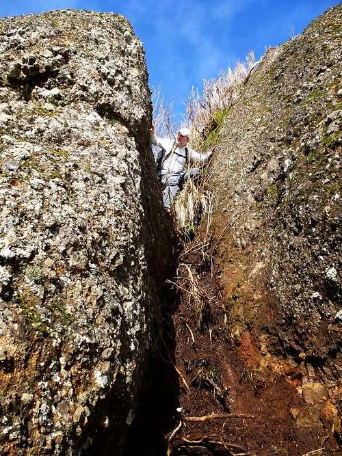 Angora Pinnacle scramble |
Red Tape
Red Tape
Brian Jenkins - Mar 9, 2015 3:51 pm - Hasn't voted
Little AngoraFYI, there is another pinnacle called Little Angora here. If you look at your map image, it's located where the second "m" in "summit" is where you have typed "Eastern Sub-summit". It goes 5.4 A0 with a hefty jump across a deep cleft/gap in the rock. Will try to post some pics soon.
EastKing - Mar 14, 2015 3:32 am - Hasn't voted
Re: Little AngoraAwesome pictures added. Will put on the main page soon.
jdavis - Sep 1, 2015 5:57 pm - Hasn't voted
Not so easyWhen you reach the end of Archcape Mill Rd (grown over trees) the route to Angora Peak is not as easy to find as you would think. It is a given the Archcap Mill Road stops at where they bulldozed tons of stuff into the road which is now overgrown with trees and doesn't even look like a road. We were just up there August 2015. We went to the right and this "path" or boot track or trample down took us to a cliff lookout just north of Angora Peak about half a mile. It is labeled in blue on the map above as "wrong path but leads to a view". For the non-climber and weekend hiker this lookout area is plenty reward instead of scrambling through the mess to the rocks. There is a makeshift bench on this lookout and a stone shelter behind in the woods that has a 50 gallon drum. The picture I am submitting is of this shack in 2006 when I was up there. It is still there in August 2015. Jack Kerwin, retired state parks ranger, ran into us up there and has plotted a loop around Angora Peak using pink ribbon. At least the return loop is pink ribbon. Jack lives in Cannon Beach and hikes this area frequently. He said he knew the guy that built the shelter. He had a backhoe (the 50 gallon drum of water) and a key to the gate (Simpson Lumber Company) and he was an ornery cuss who died recently in a fight with his son. Essentially this shack was for overnight Elk hunting trips. in 2006 there were a lot of elk dropping around that look out and up the road. in 2015 all we saw was bear scat every 30 yards (read: a lot of bear). I will post a picture of the shack and one of the bench. The lookout place is the blue markings on the map above I am planning on going up with Jack and try to get in via the "Short Sands Crossover Rd" which has no gate (at least on HWy 101 side). The Archcape Mill Road continues around Angora Peak and joins up with an off spring of Short Sands Crossover Ro. called "Short Sands something or other". Just because it's there doesn't mean it is still a road for cars. I see this via Google Satellite close up. Short Sands Crossover starts just up the road from Nehalem and river crossing.
bob carson - Dec 28, 2017 11:50 am - Hasn't voted
Angora Peak, 25 Dec 2017All these maps are wrong: USGS Arch Cape 7.5’ topo map (1985); Oregon Department of Forestry, NW Protection District (2012); map on smart phone. First, there is no bridge or road leading S from the Sewage Disposal Plant off Highway 101 at the S end of the town of Arch Cape (to quote Bert and I, “You can’t get there from here.”) Second, there is a maze of trails and old roads above 2000’ elevation. Be sure to study the earlier Summit Post information on Angora Peak, which I did not read until returning. It explains a different route to the summit, probably easier, but hard to find. We parked at the 2 gates (elevation 500’) at the start of the log road 300 m S of the Clatsop-Tillamook county line. This road leads NE back into Clatsop County past oucrops of Miocene sandstone . At elevation 900’ is a borrow pit (on the 1985 map). At about 400m past the borrow pit, turn N at the junction at elevation 1000’ (this short connecting road is on the 2012 forest map but not on the 1985 topo map). At the next junction (about elevation 1050’) turn NE up a long steady uphill grade in a roadcut of basaltic volcanic breccia (about 15 million years old). At about elevation 1700’ this road winds clockwise and climbs SE. At roughly elevation 2200’ is a brush barricade, beyond which the road is overgrown, has fallen trees across it, and in places is partially blocked by mass wasting. Although you can follow the trail along and below the abandoned road, don’t! We did, but eventually bushwhacked up a steep slope to an old road on the saddle 700 m W of Angora Peak. To get to this saddle, look for a trail 20-30 m NW of the brush barricade at 2200’. This narrow trail, marked with limited blue flagging, parallels the road on its SW side for about 10-20 m, then turns uphill and S to join an abandoned road in roughly 200 m. Near this junction is the “hermit’s cabin” (which we did not see). Follow the abandoned road SE to the saddle 700 m W of Angora Peak. From this saddle, Summit Post describes a different route to the summit of Angora Peak. We proceeded SE on the abandoned road to where pillow basalt is present in the volcanic breccia. From a benchmark in a small rockpile with blue paint the road continues E along the S side of Angora Peak. Angora Peak summit, Revenge of Angora, and Little Angora (Pinnacle) from W to E (view E from abandoned road on S side of Angora Peak summit ridge). On the topo map the N side of the peak appears to have the gentlest slope, so we continued E on the abandoned road to the junction between Angora Peak and Little Angora (Pinnacle). Turning N at this junction, we circled counterclockwise around “Revenge of Angora.” Proceeding W to an elevation of 2560’ on the N side, we encountered a place where the entire road had collapsed in a landslide. At this point a break in the cliffs allowed us to scramble S up about 100’ to the ridge crest. I tried to follow the arête-like ridge E to the summit, but was soon cliffed out. In trying to scramble E along the steep slope below the cliffs, I was surprised to see yet another overgrown road about 100’ below. Descending to the abandoned road on the S side of the ridge crest, I followed the gentle ascent E 200-300 m to old orange paint mark on a tree. From there I bushwhacked up about 100’ to the summit. Bob and Ben Carson