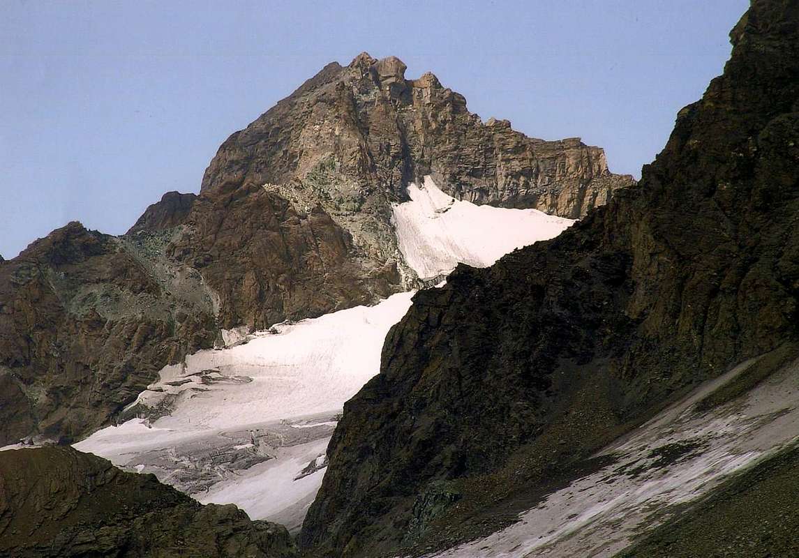
Beautiful rocky top, known also as "Guglia Verde" di Valsorey (= "Green Steeple" of Valsorey) on the Paper of the Institute Geographical Military Italian or also with the Western toponym-placename of Aiguille Verte in opposition to that suitable Oriental in the near Pic of Amiante (3.562m) as soon as over the Vert Pass (3.395m), formed by green rocks (primarily serpentiniti), positioned among the Luisettes Pass (3.401m, Map Kurz) to Southwest and the Vert Pass (3.431m) to North-northeast; besides the two crests of frontier that connect her to the above mentioned necks, it projects toward South a third brief crest that, after having formed the Footstep of the Sphinx (3.430m), it falls rocky toward the Glacier of By, dipping himself in this to quota 3.200m around. Toward North it falls instead on the small Glacier of Sonadon with her Walls NW and NE, not very tall, but steep, and composed by friable rock and not very sure for the climb (in distant times the rocks had often covered from a snowy layer or from "verglass"; such to constitute a good adhesive; currently the most greater rise of the temperatures they have reduced her to slopes even more fractured and covered by deposits and therefore also mostly dangerous). Observation that can turn to all of her itineraries of slope; this results to be the primary factor of her scarce popularity, as well as of the really modest number of the slopes that they are effected from there. Perhaps, and almost surely, they have been effected more ascensions to the beginnings of the Twenties, to the time of a characteristic mountaineering of exploration, that not for the whole remainder time; nevertheless it deserves a visit, if nothing else for her panorama and the splendid glimpse on the neighbors "colossuses" of the Mount Velan and of the Great Combin and respective glaciers and more in distance toward the Mount Gelé-Becca Faudery-Becca Crevaye-Trident of Faudery-Morion Group-Mount of Clapey-Fiorio Point-Tete Quaini-Tete Bonin-Mount of the Berrio (= of the Stone)-Mountain Chain, in East-southeast.
Bella cima rocciosa, conosciuta anche come "Guglia Verde" di Valsorey sulla Carta dell'I.G.M. oppure anche con il toponimo di Aiguille Verte Occidentale in contrapposizione a quella Orientale indicata nel vicino Pic d'Amiante (3.562 m) appena oltre il Col Vert (3.395 m), formata da rocce verdi (prevalentemente serpentiniti), posizionata tra il Col des Luisettes (3.401 m, Carta Kurz) a SO ed il Col Vert (3.431 m) a N-NE; oltre alle due creste di frontiera che la collegano ai sopra menzionati colli, proietta verso S una terza breve cresta che, dopo aver formato il Passo della Sfinge (3.430 m), precipita rocciosa verso il Glacier de By, immergendosi in questo a quota 3.200 metri circa. Verso Settentrione cade invece sul piccolo Glacier de Sonadon con le sue pareti NO e NE, non molto alte, ma ripide, e composte da roccia friabile e non molto sicura per l'arrampicata (in tempi lontani le rocce erano spesso ricoperte da uno strato nevoso o da "verglass"; tale da costituire un buon collante; attualmente il maggior rialzo delle temperature le hanno ridotte a versanti ancora più fratturati e ricoperti da detriti e quindi altresì maggiormente pericolose). Osservazione che si può rivolgere a tutti i suoi itinerari di salita; questo risulta essere il fattore primario della sua scarsa popolarità, nonché del numero veramente modesto delle salite che ne vengono effettuate. Forse, e quasi sicuramente, sono state effettuate più ascensioni agli inizi degli Anni Venti, al tempo di un caratteristico alpinismo di esplorazione, che non per tutto il restante tempo; ciononostante merita una visita, se non altro per il suo panorama e gli splendidi colpo d'occhio sui vicini "colossi" del Mont Velan e del Gran Combin e rispettivi ghiacciai e, più in lontananza verso E-SE, sulla lunga dorsale Mont Gelé-Becca Faudery-Becca Crevaye-Trident de Faudery-Gruppo dei Morion-Mont Clapey-Punta Fiorio-Tete Quaini-Tete Bonin-Mont de Berrio.
First Ascents
First on the Summit: Eugène Collomb, Louis Kurz and the mountain guides Justin Bessard and J. M. Genoud, (Jul 25th, 1887).
In Winter: Unknown.
N-NE Crest: Eugène Collomb, Louis Kurz and the mountain guides Justin Bessard and J. M. Genoud, (Jul 25th, 1887). * First replay: P. Fasana, F. Morini, A. Omio and R. Rollier, (Summer 1922).
N-NE Crest Integral Route: Osvaldo Cardellina and Luigi Gadin, (Jul 02th, 1981), in ascent.
E Wall and E Crest: Michele Baratono, Federico Chabod and Mario Schiagno, (Aug 24th, 1920), in ascent and in descent. * First replay: Osvaldo Cardellina, lone, (Aug 24th, 2010) with descent along the Southeast Crest.
E Wall directly by E Gully: Erasmo Barisone, Sandro Gallo and Massimo Strumia, (Jul 23th, 1920). * First replay: Osvaldo Cardellina, lone, (Aug 24th, 2010) with descent through the Southwest Face.
SE Ridge: Marcel Kurz, lone, (Aug 26th, 1922).
SE Ridge, Sphinx Pass and E Slope: De Rosa and Gorret, (Summer 1924).
S-SE Crest (last part) and directly on E-SE Face: Osvaldo Cardellina and Luigi Gadin, (Jul 02th, 1981), in descent.
SW Slope and SW Ridge (Standard Route): Eugène Collomb, Louis Kurz and the mountain guides Justin Bessard and J. M. Genoud, (Jul 25th, 1887), in descent.
SW Slope and SW Ridge (Standard Route): Abbot Joseph Maria Henry and the mountain guide Théodule Forclaz, (Jun 12th, 1913), in ascent.
SW Face: Osvaldo Cardellina, solo, (Aug 24th, 2010), in descent.
Getting There
BY CAR:
From Torino, Milano, etc: Motorway A5. Exit at Aosta Est.
From Switzerland: through the Grand Saint Bernard Tunnel or the namesake pass.
From France: through the Mont Blanc Tunnel or Petit Saint Bernard Pass. It is not necessary to take Motorway A5: you can drive on SS.26, in the direction of Aosta.
BY PLANE:
Aeroporto "Corrado Gex" Saint Christophe (Aosta).
Itinerary
From Aosta East exit of the motorway, follow along the SS.27 for the Gran San Bernardo Tunnel After about ten Km turn to the right toward Valpelline (964m), cross it and turn to the left to get Ollomont (1.335m) and the small built area of Glacier (1.549m), where you must start walking.
Dall'uscita del Casello Autostradale di Aosta Est, proseguire sulla SS.27 in direzione del tunnel del Gran San Bernardo; dopo circa un decina di chilometri svoltare sulla destra verso il Paese di Valpelline (964 m). Dopo averlo superato svoltare sulla sinistra e raggiungere il Paese di Ollomont (1.335 m); proseguire sino alla Frazione di Glacier (1.549 m), dove inizia l'itinerario a piedi.
Approach
From Glacier Village, through the Rosazza at Savoie Bivouac: from as soon as before the Village of Glacier (1.549m) to take the path n° 3/4/5 that verse is addressed reaching the Alpe Of it Pont (1.690m), it overcomes the Stream of By and it reaches the following of Crottes Pastures (1.733m); progressively becoming steep reaches the Alp Cheval Blanc (1.962m) and the neighbor "Lake Farinet" (1.987m). From this point, left on the right the paths n° 4/5, to continue by direction West-southwest crossing the emissary of the small lake and reaching the earth road "poderale" to the tornante (= hairpin bend; 2.025m); leaving on the right the continuation in direction of the Les Eveques Alp (2.038m), shortly and along, to reach that some Alp Porchère (2.094m) and, through direction North, that is than above or Tsa de Porchère (Tsa = Higher Pasture, generally the last; 2.290m; spring water). From this, proceeding through a long diagonal to North-northwest, to reach an alternative to quota 2.400m around, from where two possibilities of continuation of the route they are verified:
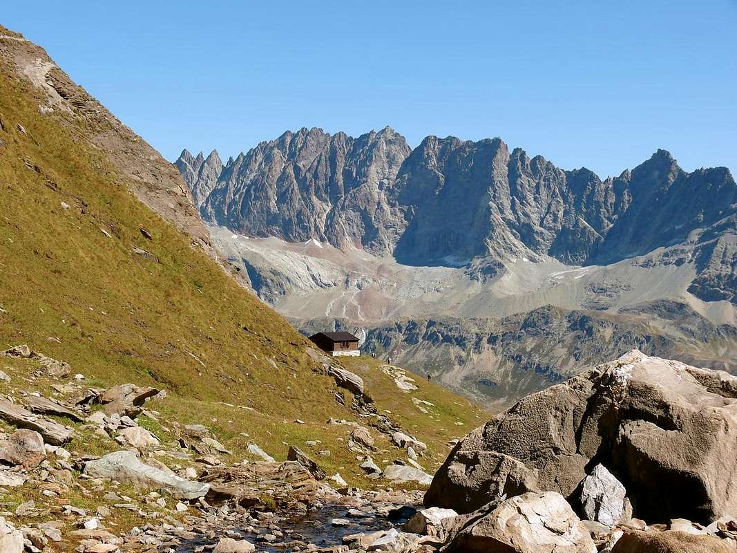
a) - to directly continue on the path of right (East) reaching the thread of crest of the Dos de Boégno Bà (= Rise of the Down Ear)and to actually follow it to the Quota 2.507m, old which folding up to the left slightly and with a steep final line to reach the Bivouac out Rosazza to the Savoie (2.651m; 3h'00).
b) - from the alternative 2.400 meters around to take the ramification of left (West) that it is addressed toward the Alpe Plan Bagò (2.436m), but not to reach her; to a further intersection in quota, as the precedent, to climb by a parallel path always initialed n° 3 and coming from the Alp Chesal (2.039m); to go up again at first it toward North, after through a short diagonal to NW to reach the Torrent of Plan Bagò, near a characteristic great wandering-erratic boulder. To get further on the right and, by a last upsurge, to reach from left toward right the Bivouac out Rosazza at the Savoie (2.651m; 3h'00).
Dal Villaggio di Glacier (1.549 m), tramite il Bivacco Rosazza al Savoie: da appena prima del Villaggio di Glacier prendere il sentiero n° 3/4/5, che si indirizza verso NE raggiungendo l'Alpe Pont (1.690 m), supera il Torrente di By e raggiunge i successivi Alpeggi di Crottes (1.733 m); diventando progressivamente più ripido raggiunge l'Alpe Cheval Blanc (1.962 m) ed il vicino "Lago Farinet" (1.987 m). Da questo punto, lasciati sulla destra i sentieri n° 4/5, continuare con direzione W-SW attraversando l'emissario del piccolo lago e raggiungendo la strada poderale al tornante 2.025 m; lasciando sulla destra la continuazione in direzione dell'Alpe Les Eveques (2.038 m), brevemente e lungo la medesima raggiungere quello dell'Alpe Porchère (2.094 m) e, tramite direzione N, quella che sta al di sopra o Tsa de Porchère (2.290 m; sorgente). Da questa procedendo con un lungo diagonale a N-NW raggiungere un bivio a quota 2.400 m circa, donde si verificano due possibilità di continuazione del percorso:
a) - proseguire direttamente sul sentiero di destra (E) raggiungendo il filo di cresta del Dos de Boégno Bà (= Dosso dell'Orecchia Abbassata) e seguirlo sino alla Quota 2.507 m; superata la quale, piegando leggermente a sinistra, e con un tratto finale più ripido arrivare al Bivacco Rosazza al Savoie (2.651 m3h'00).
b) - dal bivio 2.400 m circa prendere la ramificazione di sinistra (O), che si indirizza verso l'Alpe Plan Bagò (2.436 m), ma non raggiungerla; ad un ulteriore incrocio in quota, come il precedente, salire con un sentiero parallelo sempre siglato n° 3 e proveniente dall'Alpe Chesal (2.039 m). Risalirlo dapprima verso N, poi, con un corto diagonale a NW, raggiungere il Torrente di Plan Bagò, presso un caratteristico grande masso erratico. Allontanarsi sulla destra e, con un ultima impennata, raggiungere dalla sinistra salendo verso la destra il Bivacco Rosazza al Savoie (2.651 m; 3h'00).
Route
From the Bivacco out Rosazza/Savoye and from the neighbor of Boegno Bas Pass (2.674m) to address him toward Northeast, along a trace that with a long diagonal in light, overcoming some small valleys in grass, it brings him in direction of the unnamed lake (quota 2.688m GPS); not to reach it, on the contrary to go up, again the rather steep moraine or the snowfields, reaching the Southern Glacier of Valsorey. To always go up again it with greater inclination crossing it at the base of the long crest that the Three Brothers of Valsorey unite to the Valsorey's Five Molars and do what it is above doubling on the left (North) the rocky quota 2.931m; here the inclination goes decreasing and the run is mostly turned toward rising. To reach a rocky band that this time wanders on the right (East). To reach a rocky band below the Aiguilles des Luisettes of Valsorey, that this time wanders on the right (East); to continue with direction Northeast on the rests of the ancient Glacier of Luisettes, by now meeting place to iced-snowcapped, passing at the base of the Rateau (3.274m), of the Grand Carré (3.335m) and of the Mont Percé, coming almost since against the Southern Walls of the Three Luisettes (3.443m), where it has beginning the western branch of the Glacier de By. To actually climb on snow to the underlying rocky small gully the of Luisettes Pass and to overcome him through easy rocks for around hundred scarce meters reaching him; from the Pass to follow the easy Crest SW (I°/II°), actually to the Summit (EE/A; F+; 2h'30/3h'00).
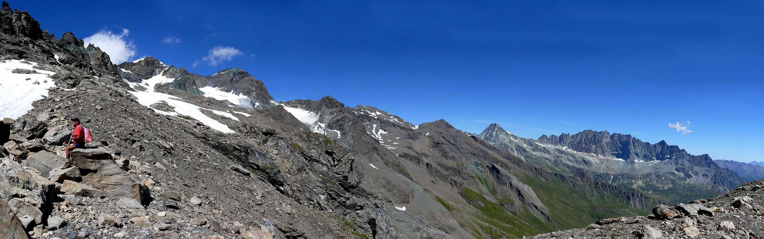
* * * In the over picture: from the Garrone Pass (3.260m around; in foreground the Southern Slopes of Grande Testa di By 3.588m) to Aiguille Verte de Valsorey (3.489m) and from left (West): of the Sphink Pass (3.430m around), Les Luisettes (3.443m; in background), Aiguille Verte with SW Face, S-SE Crest, E-SE Wall, N-NE Ridge with the Quota 3.431m from the Vert Pass (3.395m; right out in picture) or Standard Route. In middle and in bottom: the Glacier of By, among Aiguille Verte de Valsorey, Monte Sonadon (3.578m), Grande Tete of By, Piccola Testa di By (3.288m) and Punta Garrone (3.290m).
Dal Bivacco Rosazza/Savoye e dal vicino Col du Boegno Bas (2.674 m) indirizzarsi verso NE lungo una traccia che, con un lungo diagonale in leggera discesa e superando alcune piccole valli in erba, si porta in direzione del lago innominato (quota 2.688 m GPS); non raggiungerlo, bensì risalire la ripida morena, oppure i nevai soprastanti, raggiungendo il Ghiacciaio Meridionale di Valsorey. Risalirlo con pendenza sempre maggiore percorrendolo alla base della lunga cresta che unisce i Tre Fratelli di Valsorey ai Cinque Molari sempre di Valsorey, doppiando sulla sinistra (N) la quota rocciosa 2.931 m; qui la pendenza va diminuendo ed il percorso è rivolto maggiormente verso levante. Raggiungere una fascia rocciosa al di sotto delle Aiguilles des Luisettes de Valsorey, che questa volta si aggira sulla destra (E); continuare con direzione NE sui resti dell'antico Glacier de Luisettes, ormai ridotto a glacio-nevato, passando alla base del Rateau (3.274 m), del Grand Carré (3.335 m) e del Mont Percé giungendo quasi sin contro le Pareti Meridionali delle Tre Luisettes (3.443 m), dove ha inizio il ramo occidentale del Glacier de By. Salire su neve sino al canalino roccioso sottostante il Col des Luisettes e superarlo, tramite facili rocce per circa un centinaio di metri scarsi, raggiungendolo; dal Colle seguire la facile Cresta SO (I°/II°) sino alla Sommità (EE/A; F+; 2h'30/3h'00).
Varying
From the conjunction of the Glacier des Luisettes with that of By, to quota 3.150m around,o to abandon on the left (North) the route for the of Luisettes Pass and, continuing toward East, to go himself against the SW Wall about the mountain through a snowfield in gradual inclination, towards quota 3.250m around, it reaches the superior rocky part; through an enough wide channel, generally snowy in beginning of season, on broken and routs rocks, not difficult (I°/I°+), to reach the Crest SW about frontier fifty-fifty road around departing from the of Luisettes Pass and with this, as in the preceding itinerary, to conclude in Peak (EE/A; F+; 2h'45/3h'15).
Dalla congiunzione del Glacier des Luisettes con quello di By, a quota 3.150 metri circa, abbandonare sulla sinistra (N) la via per il Col des Luisettes e, proseguendo verso oriente, portarsi contro la Parete SO della montagna tramite un nevaio in graduale pendenza, che da quota 3.250 metri circa raggiunge la parte rocciosa superiore; per mezzo di un abbastanza largo canale, in genere innevato in inizio di stagione, su rotte rotte e non difficili (I°/I°+) raggiungere la Cresta SO di frontiera a metà strada circa, partendo dal Col des Luisettes, e con questa, come nell'itinerario precedente, concludere in Vetta (EE/A; F+; 2h'45/3h'15).
Difficulty
Both routes can be considered EE/A, F+.
L'itinerario è classificato EE/A, F+.
Equipment
Standard mountaineering equipment.
Da alpinismo.
Huts
Bivacco ROSAZZA-SAVOYE
Campings
Remember that free camping is forbidden (except for emergency reasons, over 2.500m, from darkness until dawn).
Mountain Conditions
You can get meteo information at the official site of the Regione Valle d'Aosta:
Parents refers to a larger category under which an object falls. For example, theAconcagua mountain page has the 'Aconcagua Group' and the 'Seven Summits' asparents and is a parent itself to many routes, photos, and Trip Reports.

 8765 Hits
 88.61% Score
 27 Votes