The "glacier" is somewhat of an unusual and interesting feature for Utah. A perhaps little known fact is that the glacier reportedly used to have some distinct (by Rockies standards) and visible crevasses before the "Dust Bowl Drought" of the 1930s. Some of the old photos are available at BYU or in Kelsey's book on Timpanogos, and a few are posted in the section below.
Although the feature has been referred to as a glacier (sometimes affectionately) for many years, the status of the glacier/snowfield/icefield had been debated for just as long.
Even though the feature has been referred to a glacier for a long time, most photos of any time period (especially after the 1930s) give it the appearance of a permanent snowfield or rock glacier than a large glacier in places like Washington or Alaska. The 1994 crevasse did cause some stir and many believe that the glacier still survives.
Other than the 1994 and 2016 crevasses that opened up in the center of the talus bulge on the Timpanogos Glacier, there have been few recent signs that I know of that have pointed to actual crevasses or moving ice, though those two incidences 22 years apart are intriguing.
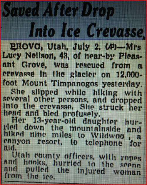
In the early 1900s, the latest first-hand report I can find reporting any crevasses is from 1916. Other first-hand reports of crevasses were in 1907 and 1912. If you know of any first-hand reports of actual witnesses after 1916, please let me know. Some second-hand accounts claim that there were occasional small crevasses until the Dust Bowl Drought. There were also reported crevasses in 1942 and 1946, but what they looked like is entirely unclear since I haven't seen any photographs of them. A news article actually says that one person had to be rescued from a crevasse in 1942 (see below).
After the 1930's drought, much of the glacier/surface snow melted and has never recovered. As far as we know, only two incidences of crevasses (1942 and 1946) have ever been mentioned between the dust bowl drought and 1994. Also after the Dust Bowl Drought, the glacier was thought to be more of a perpetual snowfield over a rock glacier until the surface snow completely (or almost completely) melted for the first time in the drought of 1994. During that year a large crevasse opened up in the talus, revealing hidden glacial ice below.
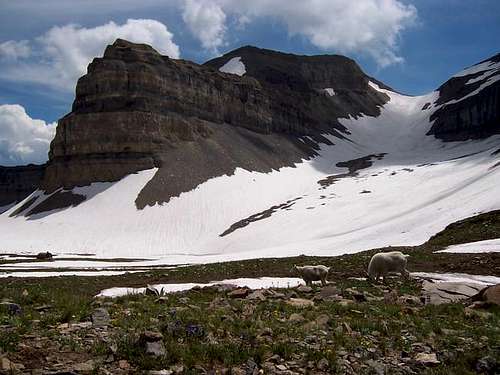
For now, it appears the glacier survives and is protected under the talus. The surface snow and ice also completely melted (or at least almost completely melted) in 2003.
Also of interest, a possible glacier, mostly covered in rocks, but with a visible crevasse in the ice was discovered hidden on a remote area Lone Peak, just to the north of Timpanogos.
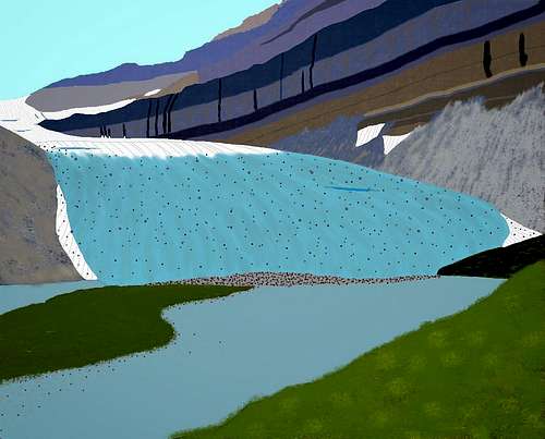
Timp Glacier concept art- mid-1800s
The Timpanogos Glacier as it may have appeared at the height of the Little Ice Age in the mid-1800s. At that time there were probably three glaciers on Timpanogos: this one, another below the north face, and one in the Cascade Cirque. There are also very recent terminal and lateral moraines below the permanent icefield in the Cascade Cirque.
There may be glacial activity on the Timpanogos Glacier today; some images show a possible crevasse.
TImpanogos Glacier as it may have appeared at the height of the Little Ice Age in the mid-1800s.
The Timpanogos Glacier in the Early 1900s
The winter of 1904 to 1905 was one of the least snowy years ever recorded in the Wasatch. It was the driest November (zero precipitation in most of the Wasatch) and one of the driest Decembers on record. January and February snowfall was way below normal. Only March had slightly above-normal precipitation. Snowfall in Salt Lake City was less than 41% of normal for the season.
Notice that much of the surface snow has melted, which was unusual for the time period. Dirty glacial ice may be present in this photo in the upper right part of the cirque. Also notice the hanging ice on the north face.
This is probably the least amount of snow/ice present on Timpanogos any time in the early 1900s or anytime before the Dust Bowl Droughts of the 1930s.
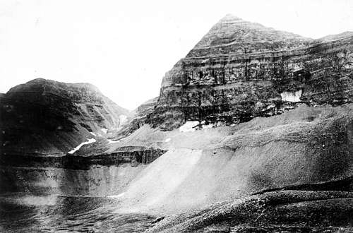
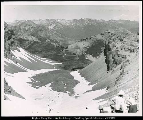
A late September photo of the Timp Glacier during an extreme drought year in 1905. USGS Photo.
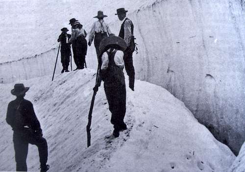
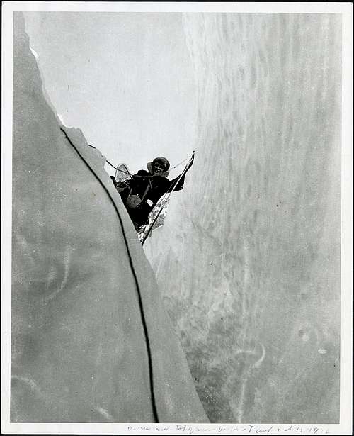
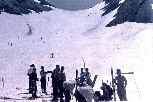
This is the Timpanogos Glacier as it appeared in 1907 (normal snow year). Notice the crevasse in the photo. One trip report from 1912 makes the statement that the glacier had “a series of beautiful crevasses” to pass on route to the summit.
Timpanogos Glacier as it appears in August 1907. BYU Photo archives; John C. Swensen
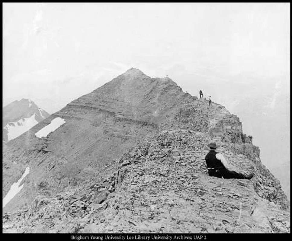
Anthony C Lund rests near the peak of Mt Timpanogos in 1912, the glacier can be seen in the background.
Excerpt from Dean R Brimhall's ascent of Mount Timpanogos in 1916:
I believe most people call that part of the ridge at which the glacier begins the saddle. It was here we obtained two of our best pictures. One of the eastern or back part of Timpanogos and the other of a large ice crevice. In true glacier fashion the mass of snow that had collected in the magnificent amphitheater below, had moved several feet and left a number of deep beautiful crevices.
A crevasse in the Timpanogos Glacier in 1916.
The Timpanogos Glacier in the 1920s
Photos from this time period are hard to find and it's hard to tell what is going on here from the few photos available.
The top of the glacier in late July 1925.
Timpanogos Glacier in the 1930s
Unfortunately, photos from this time period are hard to obtain. The Dust Bowl Drought of the 1930s took a heavy toll on the Timpanogos Glacier, and much of the surface ice melted. The worst year of all was 1934, and the glacier shrunk drastically in just that one year. This according to the reports and articles from the Annual Timp Hike, which took place every year between 1912 and 1970. Only the 1942, 1946, and 1994 crevasses were reported after the Drought. The glacier took on the appearance of a perpetual snowfield, more than a true glacier.
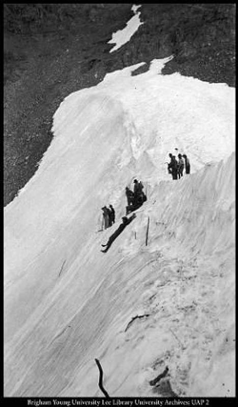
Early 1930's Annual Timp Hike.
The Timpanogos Glacier in the 1940s
The 1940s provided a welcome relief from the drought and average or above-average precipitation returned for several years. During the 1940s several mid-summer ski races were held, usually in late July.
During 1942, there was a reported fall into a crevasse:
1942 News Article.
Timpanogos Glacier in late July, 1944. This was a fairly normal snow year, but with a wet spring.
One crevasse was reported in July of 1946. Whether this was a true crevasse (as opposed to ice caving in around the lake or snow melting above a rocky outcrop) is not known.
A July 30, 1949 (a very heavy snow year) photo of the Timpanogos Glacier. During the 1940's, ski races were held on the glacier; Ray Stewart Photo
The Timpanogos "Glacier" in the 1950s-1980s
During the 1950s, 1960s, and 1970s, with alternating dry and wet years, the “glacier” waxed and waned, but always had the appearance of a perpetual snowfield. The early to mid-1980s could be considered to be generally warm and wet. Heavy snowfall years regenerated parts of the snowfield, and it appeared that the perpetual snowfield might recover to its previous 1940’s size, but not to the glacier it was before the 1940s.
However, the late 1980’s produced a severe drought that took a toll on the "glacier", and by 1988 the glacier/snowfield was smaller than it had ever been to that date in recorded history. If you have any photographs from the 1950s, 1960s, 1970s, or 1980s, please add them to the article.
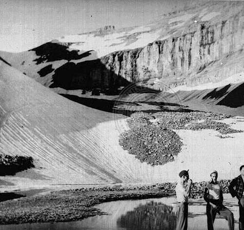
Timpanogos Glacier circa early 1950's. This photo would have to be taken before 1956 as from 1956 and after, all annual Timp Hikes made the ascent up the new trail and came down the glacier, rather than ascended the glacier.
The Timpanogos "Glacier" in 1993 and 1994
Some wet years were not enough to compensate for the drought, and although 1993 was a heavy snow year, the “perpetual” snowfield actually melted out completely (or close to completely) in the terribly dry and hot year of 1994. This was the first time in recorded history that the “perpetual” snowfield melted away. During that year a large crevasse opened up in the talus, revealing glacial ice below. Unfortunately, geologists believe this was probably a meltwater channel and not a true crevasse. Even so it was a remarkable and valuable look into this interesting feature. For now, it appears the glacier survives and is protected under the talus.
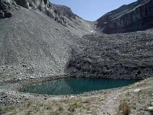
My photo of the Timpanogos "Glacier" from Emerald Lake on September 15, 1993
Addition by SP member hyperphil:
I was a crevasse witness. I was on TERT in 1993 [sic-actually 1994?] when the crevasse opened up. John Moellmer found it, and Paul Hart and I went up to check it out. It was eery--deep blue ice, 40 feet thick at least. The hole was DEEP. If you fell in, you'd be 30th-century archaeological curiosity. I have a photo of it somewhere in my infernally huge collection of slides. Glen Meyer, the TERT director, got a glaciology team from Washington State to assay the ice. Their results were inconclusive as to whether it was truly glacial. The fact that the crevasse did not reappear in 2004 suggests it was moving, that is, glacial. Glacial or not, I NEVER walk down the middle of the snowfield any more.
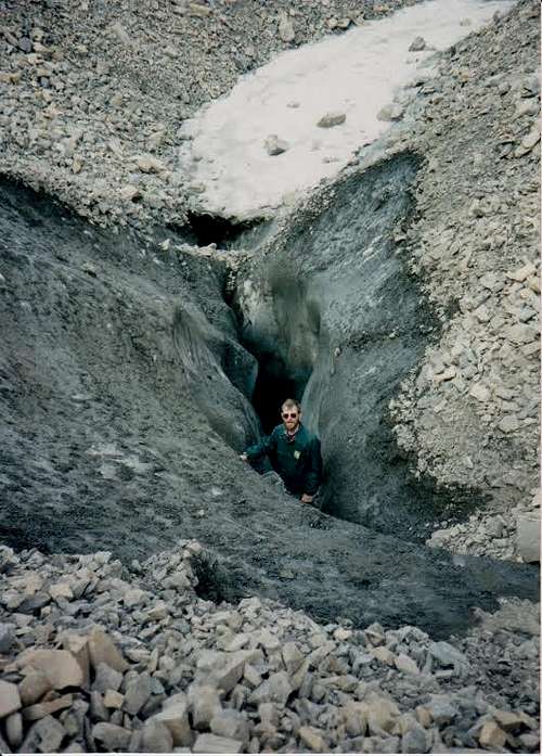
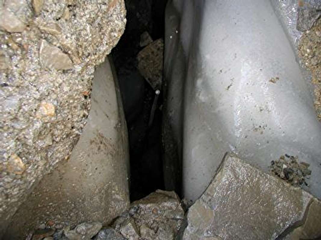
A crevasse on the normally buried Timpanogos Glacier in 1994. The man in this photo is actually standing on some rocks that fell and got wedged in, the actual bottom was reported to be at least forty feet down. Glen Meyer, the director of the Timpanogos Emergency Response Team, took this photo, which is used with permission.
A shot into the depths of the crevasse.Glen Meyer photo and used with permission.
The Timpanogos "Glacier" in 2003
Despite some wet years, the drought continues to take a toll on the now sometimes invisible “glacier”. Notice in this photo from September 2003, that the surface ice and perpetual snowfield has once again melted almost completely. When comparing the photos from almost 100 years ago, they are just a reminder of what the “glacier” used to be.
Interestingly, according to the TERT, there was another crevasse or pit that opened up in the late 1990's or early 2000's. It was reportedly surrounded by rocky slopes too steep to approach. Someone threw a rock in and it bounced once off the side and took 2.7 seconds (if the volunteer's memory is correct) to reach the bottom. From this somebody calculated that it was over 100 feet deep.
At or around this time, BYU reportedly dug about 3-5 feet down to the ice at the top of the rock glacier below the bottom of the steep snowfield. They were said to have obtained a core sample but it was somehow contaminated. They also apparently tried to study the crystal morphology (shape) of the ice, but either the results were inconclusive or they obtained no meaningful data.
If anyone has any pictures of this or knows anything about it, please let us know.
The Pluggers' photo of the Timpanogos "Glacier" on September 17, 2003
2016 Update
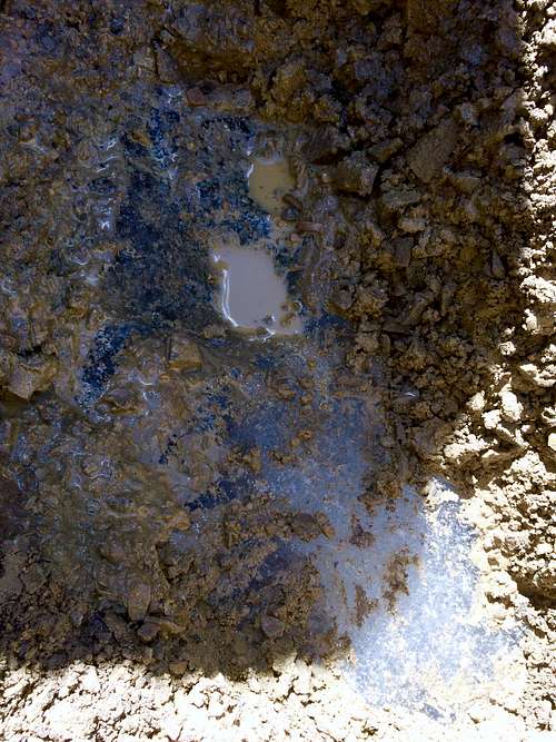
On September 3 of 2016, one of the authors of this article found a meltwater pit in the uppermost flow lobe of the rock glacier, around where BYU is said to have dug for ice. It was filled with opaque milky water and had a small amount of exposed glacial ice by the water's edge. The author dug to the ice in the upper slope of the pit. It was blue with a hint of gray and contained air bubbles, meaning it was probably true glacial ice, i.e. formed from snowfall and not permafrost. The wall of the hole he dug was about 3 feet at the highest.
The Timpanogos "Glacier" Present and Future
Today, the Timpanogos Glacier is what geologists call a "rock glacier," which is a glacier-covered with rocky debris, a pile of rocky debris cemented by ice, or anything in between. It appears to be divided into three main flow lobes, possibly from different glaciers and/or rock glaciers forming at different times.
The largest one reaches from below the steep snowfield to Emerald Lake and may have recently become inactive, (since the lake was not milky despite low water levels in 2016) but it is not certain.
The uppermost one is on the left side of the glacier when facing toward it. It begins at the bottom of the steep snowfield and covers roughly a third of the whole glacier. It is probably the most active.
Stretching from the bottom of that one but not reaching the lake is another one. This last one has plants growing on it and is probably dead.
The three flow lobes are easily visible on any satellite/aerial image that is relatively free of snow.
No one knows for sure what the future holds for this unique feature in Utah. Some recent winters have produced above-normal snowfall, but many others have been dry, and it would take decades of accumulation to bring back the surface glacier of 100 years ago.
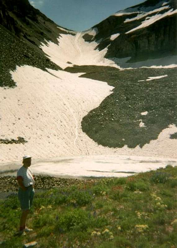
Gjagiels' Photo from August 9, 2005 in a very heavy snow year.
The Timpanogos Glacier on August 30, 2014; a drought year.
More?
If anyone else can dig up any old photos of the Timp Glacier, it would be greatly appreciated. Any photos or scans of photos from the late 1800s through the 1950s would be greatly appreciated.
Also, if anyone has any more information on the crevasse that opened up in 1994 or the one after, please let us know.
If you have ever witnessed any type of crevasse or exposed ice on the Timp Glacier, please post any information that might be useful.
Also, if anyone has witnessed the surface snow and ice melting completely in any other years besides 1994 and 2003, please let us know.
Thanks for the clarification, I would not have suspected it was indeed a glacier, rather than a perpetual snowfield. I hope it won't disappear completely.
This is a fascinating history of the glacier Scott. That is one magnificent mountain and it is sad to witness the disappearance of one of its salient features. I would guestimate that only a couple percent of Americans have ever been on a glacier; the rest are missing one of nature's greatest wonders.
Thanks for a fascinating article, an excellent example of 'citizen science'.
After some 50 years of examining rock glacier in various parts of the world I have only just come across this example -even though I have written about them in Colorado (Arapaho), Sierra Nevada and Alaska. Regardless of anthropogenioc CO2 emission etc, there is little doubt that small glaciers were down-wasting (ie losing ice mass or 'retreating') from the end of the Little Ice Age (say 1900, it varies in the world) The there has been a long discussion about the nature of rock glaciers. Some believe that it is a mix of debris and snow/ice that flows (creeps) under its self mass. However, there are those who believe (like myself) that glacier ice has, in some cases for small glaciers, been burried by weathered rock debris from the backwalls of cirques. Even <1m will be sufficient to cut the ablation to near zero. Under these circumstanaces creep rates are very low but the glacir more or less remains (so Emerald lake remains clear because there is very little melwater, with little silt, reaches it. Noel Potter's work (Galena peak, WY) clear shows very old ice proptected in this way - although some have tried to descredit this. But Timp shows the small glacier, with crevasses etc as well described, but the interesting point for me is finding out when (and for how long) the debris started to accumulate on the glacier surface. From the photos it looks as if a great deal had accummulated by the 1950s but it could well be that the wet springs mentioned brought down a lot of debris form the ever-widening cirque backwall by slush avalalnces and rockfla. I'd be very interested in hearing abou evidence for this debris input. You can see my rock glacier credentials by Google Scholar search: Brian Whalley. Or please contact me at b.whallery@sheffield.ac.uk Thanks
Parents refers to a larger category under which an object falls. For example, theAconcagua mountain page has the 'Aconcagua Group' and the 'Seven Summits' asparents and is a parent itself to many routes, photos, and Trip Reports.


Comments
Post a Comment