100 Years on the Timpanogos Glacier

100 Years on the Timpanogos Glacier

Page Type Page Type: Article

Overview

The "glacier" is somewhat of an unusual and interesting feature for Utah. A perhaps little known fact is that the glacier reportedly used to have some distinct (by Rockies standards) and visible crevasses before the "Dust Bowl Drought" of the 1930s. Some of the old photos are available at BYU or in Kelsey's book on Timpanogos, and a few are posted in the section below.

Although the feature has been referred to as a glacier (sometimes affectionately) for many years, the status of the glacier/snowfield/icefield had been debated for just as long.

Even though the feature has been referred to a glacier for a long time, most photos of any time period (especially after the 1930s) give it the appearance of a permanent snowfield or rock glacier than a large glacier in places like Washington or Alaska. The 1994 crevasse did cause some stir and many believe that the glacier still survives.

Other than the 1994 and 2016 crevasses that opened up in the center of the talus bulge on the Timpanogos Glacier, there have been few recent signs that I know of that have pointed to actual crevasses or moving ice, though those two incidences 22 years apart are intriguing.

In the early 1900s, the latest first-hand report I can find reporting any crevasses is from 1916. Other first-hand reports of crevasses were in 1907 and 1912. If you know of any first-hand reports of actual witnesses after 1916, please let me know. Some second-hand accounts claim that there were occasional small crevasses until the Dust Bowl Drought. There were also reported crevasses in 1942 and 1946, but what they looked like is entirely unclear since I haven't seen any photographs of them. A news article actually says that one person had to be rescued from a crevasse in 1942 (see below).

After the 1930's drought, much of the glacier/surface snow melted and has never recovered. As far as we know, only two incidences of crevasses (1942 and 1946) have ever been mentioned between the dust bowl drought and 1994. Also after the Dust Bowl Drought, the glacier was thought to be more of a perpetual snowfield over a rock glacier until the surface snow completely (or almost completely) melted for the first time in the drought of 1994. During that year a large crevasse opened up in the talus, revealing hidden glacial ice below.

For now, it appears the glacier survives and is protected under the talus. The surface snow and ice also completely melted (or at least almost completely melted) in 2003.

Also of interest, a possible glacier, mostly covered in rocks, but with a visible crevasse in the ice was discovered hidden on a remote area Lone Peak, just to the north of Timpanogos.

Timp Glacier concept art- mid-1800s

The Timpanogos Glacier as it may have appeared at the height of the Little Ice Age in the mid-1800s. At that time there were probably three glaciers on Timpanogos: this one, another below the north face, and one in the Cascade Cirque. There are also very recent terminal and lateral moraines below the permanent icefield in the Cascade Cirque.

There may be glacial activity on the Timpanogos Glacier today; some images show a possible crevasse.

TImpanogos Glacier as it may have appeared at the height of the Little Ice Age in the mid-1800s.TImpanogos Glacier as it may have appeared at the height of the Little Ice Age in the mid-1800s.

The Timpanogos Glacier in the Early 1900s

The winter of 1904 to 1905 was one of the least snowy years ever recorded in the Wasatch. It was the driest November (zero precipitation in most of the Wasatch) and one of the driest Decembers on record. January and February snowfall was way below normal. Only March had slightly above-normal precipitation. Snowfall in Salt Lake City was less than 41% of normal for the season.

Notice that much of the surface snow has melted, which was unusual for the time period. Dirty glacial ice may be present in this photo in the upper right part of the cirque. Also notice the hanging ice on the north face.

This is probably the least amount of snow/ice present on Timpanogos any time in the early 1900s or anytime before the Dust Bowl Droughts of the 1930s.

Timpanogos in1909A late September photo of the Timp Glacier during an extreme drought year in 1905. USGS Photo.

This is the Timpanogos Glacier as it appeared in 1907 (normal snow year). Notice the crevasse in the photo. One trip report from 1912 makes the statement that the glacier had “a series of beautiful crevasses” to pass on route to the summit.

1907 PhotoTimpanogos Glacier as it appears in August 1907. BYU Photo archives; John C. Swensen
Near the top of timp in 1912Anthony C Lund rests near the peak of Mt Timpanogos in 1912, the glacier can be seen in the background.


Excerpt from Dean R Brimhall's ascent of Mount Timpanogos in 1916:

I believe most people call that part of the ridge at which the glacier begins the saddle. It was here we obtained two of our best pictures. One of the eastern or back part of Timpanogos and the other of a large ice crevice. In true glacier fashion the mass of snow that had collected in the magnificent amphitheater below, had moved several feet and left a number of deep beautiful crevices.

A crevasseA crevasse in the Timpanogos Glacier in 1916.

The Timpanogos Glacier in the 1920s

Photos from this time period are hard to find and it's hard to tell what is going on here from the few photos available.

Timpanogos Glacier 1925The top of the glacier in late July 1925.

Timpanogos Glacier in the 1930s

Unfortunately, photos from this time period are hard to obtain. The Dust Bowl Drought of the 1930s took a heavy toll on the Timpanogos Glacier, and much of the surface ice melted. The worst year of all was 1934, and the glacier shrunk drastically in just that one year. This according to the reports and articles from the Annual Timp Hike, which took place every year between 1912 and 1970. Only the 1942, 1946, and 1994 crevasses were reported after the Drought. The glacier took on the appearance of a perpetual snowfield, more than a true glacier.

Emerald LakeEarly 1930's Annual Timp Hike.


The Timpanogos Glacier in the 1940s

The 1940s provided a welcome relief from the drought and average or above-average precipitation returned for several years. During the 1940s several mid-summer ski races were held, usually in late July.

During 1942, there was a reported fall into a crevasse:

1942 Crevasse Article1942 News Article.
Emerald Lake 1944Timpanogos Glacier in late July, 1944. This was a fairly normal snow year, but with a wet spring.

One crevasse was reported in July of 1946. Whether this was a true crevasse (as opposed to ice caving in around the lake or snow melting above a rocky outcrop) is not known.

July 30, 1949 PhotoA July 30, 1949 (a very heavy snow year) photo of the Timpanogos Glacier. During the 1940's, ski races were held on the glacier; Ray Stewart Photo

The Timpanogos "Glacier" in the 1950s-1980s

During the 1950s, 1960s, and 1970s, with alternating dry and wet years, the “glacier” waxed and waned, but always had the appearance of a perpetual snowfield. The early to mid-1980s could be considered to be generally warm and wet. Heavy snowfall years regenerated parts of the snowfield, and it appeared that the perpetual snowfield might recover to its previous 1940’s size, but not to the glacier it was before the 1940s.

However, the late 1980’s produced a severe drought that took a toll on the "glacier", and by 1988 the glacier/snowfield was smaller than it had ever been to that date in recorded history. If you have any photographs from the 1950s, 1960s, 1970s, or 1980s, please add them to the article.

Timp Glacier circa 1950-1970Timpanogos Glacier circa early 1950's. This photo would have to be taken before 1956 as from 1956 and after, all annual Timp Hikes made the ascent up the new trail and came down the glacier, rather than ascended the glacier.

The Timpanogos "Glacier" in 1993 and 1994

Some wet years were not enough to compensate for the drought, and although 1993 was a heavy snow year, the “perpetual” snowfield actually melted out completely (or close to completely) in the terribly dry and hot year of 1994. This was the first time in recorded history that the “perpetual” snowfield melted away. During that year a large crevasse opened up in the talus, revealing glacial ice below. Unfortunately, geologists believe this was probably a meltwater channel and not a true crevasse. Even so it was a remarkable and valuable look into this interesting feature. For now, it appears the glacier survives and is protected under the talus.

Timp Glacier from Emerald...My photo of the Timpanogos "Glacier" from Emerald Lake on September 15, 1993


Addition by SP member hyperphil:

I was a crevasse witness. I was on TERT in 1993 [sic-actually 1994?] when the crevasse opened up. John Moellmer found it, and Paul Hart and I went up to check it out. It was eery--deep blue ice, 40 feet thick at least. The hole was DEEP. If you fell in, you'd be 30th-century archaeological curiosity. I have a photo of it somewhere in my infernally huge collection of slides. Glen Meyer, the TERT director, got a glaciology team from Washington State to assay the ice. Their results were inconclusive as to whether it was truly glacial. The fact that the crevasse did not reappear in 2004 suggests it was moving, that is, glacial. Glacial or not, I NEVER walk down the middle of the snowfield any more.

Timpanogos Glacier CrevasseA crevasse on the normally buried Timpanogos Glacier in 1994. The man in this photo is actually standing on some rocks that fell and got wedged in, the actual bottom was reported to be at least forty feet down. Glen Meyer, the director of the Timpanogos Emergency Response Team, took this photo, which is used with permission.
Timp Glacier crevasse 1994A shot into the depths of the crevasse.Glen Meyer photo and used with permission.

The Timpanogos "Glacier" in 2003

Despite some wet years, the drought continues to take a toll on the now sometimes invisible “glacier”. Notice in this photo from September 2003, that the surface ice and perpetual snowfield has once again melted almost completely. When comparing the photos from almost 100 years ago, they are just a reminder of what the “glacier” used to be.

Interestingly, according to the TERT, there was another crevasse or pit that opened up in the late 1990's or early 2000's. It was reportedly surrounded by rocky slopes too steep to approach. Someone threw a rock in and it bounced once off the side and took 2.7 seconds (if the volunteer's memory is correct) to reach the bottom. From this somebody calculated that it was over 100 feet deep.

At or around this time, BYU reportedly dug about 3-5 feet down to the ice at the top of the rock glacier below the bottom of the steep snowfield. They were said to have obtained a core sample but it was somehow contaminated. They also apparently tried to study the crystal morphology (shape) of the ice, but either the results were inconclusive or they obtained no meaningful data.

If anyone has any pictures of this or knows anything about it, please let us know.

Emerald Lake and the Timp...The Pluggers' photo of the Timpanogos "Glacier" on September 17, 2003

2016 Update

On September 3 of 2016, one of the authors of this article found a meltwater pit in the uppermost flow lobe of the rock glacier, around where BYU is said to have dug for ice. It was filled with opaque milky water and had a small amount of exposed glacial ice by the water's edge. The author dug to the ice in the upper slope of the pit. It was blue with a hint of gray and contained air bubbles, meaning it was probably true glacial ice, i.e. formed from snowfall and not permafrost. The wall of the hole he dug was about 3 feet at the highest.

Timp Glacier Unburied Ice 2016

The Timpanogos "Glacier" Present and Future

Today, the Timpanogos Glacier is what geologists call a "rock glacier," which is a glacier-covered with rocky debris, a pile of rocky debris cemented by ice, or anything in between. It appears to be divided into three main flow lobes, possibly from different glaciers and/or rock glaciers forming at different times.

The largest one reaches from below the steep snowfield to Emerald Lake and may have recently become inactive, (since the lake was not milky despite low water levels in 2016) but it is not certain.

The uppermost one is on the left side of the glacier when facing toward it. It begins at the bottom of the steep snowfield and covers roughly a third of the whole glacier. It is probably the most active.

Stretching from the bottom of that one but not reaching the lake is another one. This last one has plants growing on it and is probably dead.

The three flow lobes are easily visible on any satellite/aerial image that is relatively free of snow.

No one knows for sure what the future holds for this unique feature in Utah. Some recent winters have produced above-normal snowfall, but many others have been dry, and it would take decades of accumulation to bring back the surface glacier of 100 years ago.

The Timp Glacier (top right)...Gjagiels' Photo from August 9, 2005 in a very heavy snow year.
The Timpanogos Glacier on August 30, 2014; a drought year.

More?

If anyone else can dig up any old photos of the Timp Glacier, it would be greatly appreciated. Any photos or scans of photos from the late 1800s through the 1950s would be greatly appreciated.

Also, if anyone has any more information on the crevasse that opened up in 1994 or the one after, please let us know.

If you have ever witnessed any type of crevasse or exposed ice on the Timp Glacier, please post any information that might be useful.

Also, if anyone has witnessed the surface snow and ice melting completely in any other years besides 1994 and 2003, please let us know.

It would be greatly appreciated.


Comments

Post a Comment
Viewing: 21-40 of 43
dillweed

dillweed - Jun 2, 2006 6:31 am - Voted 10/10

a side note

Scott, I tried to post this REPLY to your Climber's Log entry on Timp, and although it posted as a regular reply, it did not show up on either of our profile pages, so I will put it here.

Referring to this post

I completely agree with you Scott, by I am very surprised to hear that coming from you - you have climbed so many summits in the Rockies. Wow. I always just sort of wondered whether I got lucky by growing up near such an incredible mountain, but as I explore other beautiful places, I can't help but compare them with Timp, and most fall short. It really is an amazing place. Glad to see that someone agrees!

Scott

Scott - Jun 2, 2006 3:53 pm - Hasn't voted

Re: a side note

you have climbed so many summits in the Rockies

Actually only the sections between West Central Montana and southern Colorado, and no climbs in the Canadian Rockies. I should have said US Rockies, though I was only repeating the statement made by Michael Kelsey, author of the Climbers and Hikers Guide to the World's Mountains.

Scott Wesemann

Scott Wesemann - Jul 3, 2006 4:23 pm - Hasn't voted
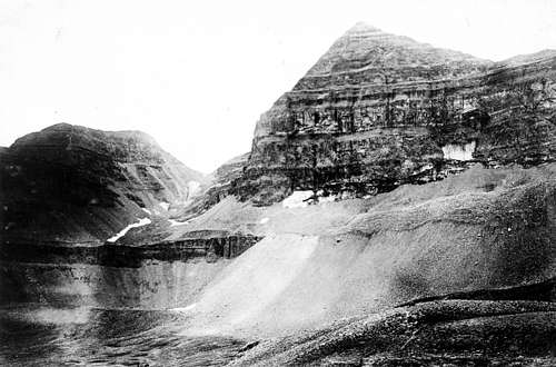
Impressive!

Very impressive article. I have been watching the Glacier for years now and I was really sad to see it completely dry in 2003. I really liked the old pictures and can only imagine what it would have been like to climb it in the early 1900's.

sopwith21 - Jul 22, 2006 1:51 am - Hasn't voted

Tragic, but not forever

The glacier's epitaph is a bit premature. I'm sorry that its not here to enjoy now, but as with everything else, it will return sooner or later. All creation is cyclical and as much as we would like to think otherwise, we humans don't have near the impact on it that we would dearly love to imagine.

The photo series is really amazing and a joy to study. Thanks for posting it.

BobSmith

BobSmith - Nov 11, 2006 1:27 pm - Voted 10/10

Amazing.

What a great summitpost. Very simply told in merely the photographs that greenhouse gases are changing our planet.

Bob Sihler

Bob Sihler - Dec 29, 2006 12:09 am - Voted 10/10

Amazing, yet sad

I've seen similar evidence in Glacier National Park and the Canadian Rockies. The naysayers just piss me off when the evidence is so glaringly obvious. It's reasonable to debate what, if anything, to do, but denying it is just ignorant or dishonest.

I was on the "glacier" in 2002-- what a difference compared to that 2003 photo!

ktnbs

ktnbs - Dec 29, 2006 6:16 am - Hasn't voted

just re-read

still very fascinating.

hyperphil

hyperphil - Feb 13, 2007 8:28 pm - Hasn't voted
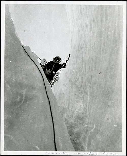
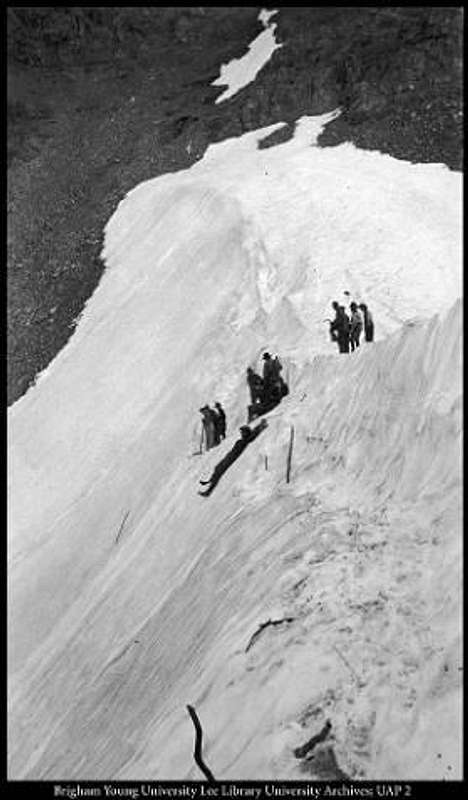
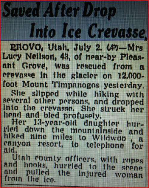
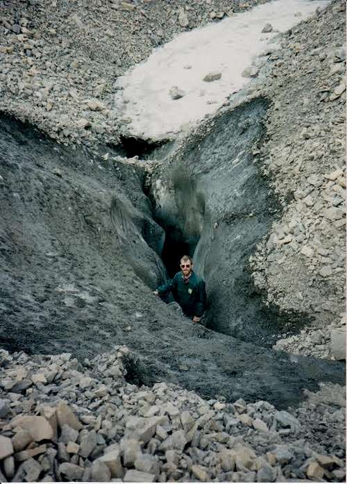
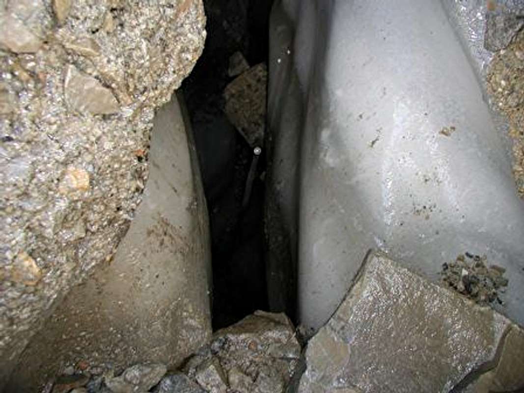
I was crevasse witness

I was on TERT in 1993 when the crevasse opened up. John Moellmer found it, and Paul Hart and I went up to check it out. It was eery--deep blue ice, 40 feet thick at least. The hole was DEEP. If you fell in, you'd be 30th century archaeological curiousity. I have a photo of it somewhere in my infernally huge collection of slides. Glen Meyer, the TERT director, got a glaciology team from Wash State to assay the ice. Their results were inconclusive as to whether it was truly glacial. The fact that the crevasse did not reappear in 2004 suggests it was moving, that is, glacial. Glacial or not, I NEVER walk down the middle of the snowfield any more.

Scott

Scott - Feb 13, 2007 9:44 pm - Hasn't voted

Thanks!

I have added your comments to the article. If you ever find the photos feel free to post them to this article!

Sam Dunford - Mar 15, 2013 8:49 pm - Voted 10/10

Re: I was crevasse witness

I am glad that you posted this, and I would really like to know more. Exactly where on the glacier was the crevasse? How thick was the layer of rocks covering the ice? In what way were the results inconclusive? (i.e. in x it resembled glacial ice, but in y it did not) Would it be possible to find the photo and upload it?

Once again, thanks for posting the comment, and I would really like to know more :-)

Collin2

Collin2 - Jul 6, 2007 11:54 pm - Hasn't voted

My Dad's Resopnse

I sent my Dad this post and his reply may be interesting to some of you.

Collin,

Very interesting series of dramatic photos of the Timp Glacier. When I was
young it was thought to be a snowfield rather than a glacier, though most
still called it a glacier. I used to slide down it on my buttocks and it
hurt, but I didn't haul skis up to the top of Timp.

In the 1960s, when I climbed to the top of Timp at least 3 or 4 times, there
were big boulders protruding up through the glacier and the snow melted
around these rocks so that there was a hole between the glacier and the
rocks that might be six or seven feet. We avoided as best we could any
collision with the rocks on our way sliding down. At least that's what I
recall then.

Excuse me for being lengthy. I know you just sent me photos to look at, but
I still wanted to say a few things in regard to global warming theories. To
me, son, I don't have a big argument as to whether the planet's overall
climate may have warmed up a tad or not, but rather, my big argument with
the doomsayers of global warming stems from the claims by some that our
global climate is shifting dramatically into a warming trend that is mostly
caused by MANKIND. I believe that's ridiculous. Over 70% of earth is
unpopulated ocean surface effected mostly by the SUN. The polar caps have
few men on them. The vast northern areas across Russia and Canada remain
mostly unpopulated. Nature, especially the SUN, is the bigger factor in any
climate change by far.

Humor me with a bit of remanicing. When I first got married, in 1971, the
news media was terrifying everyone for a season with claims that scientists
believed we were moving into a new ICE AGE. NEWSWEEK and NATIONAL
GEOGRAPHIC made these coming ICE AGE claims. Then, when the ice-sheets and
ice age didn't materialize by the 1980s, we suddenly were being hit with
frightening claims that an OZONE HOLE was evidence that mankind was
destroying our atmosphere by using aresoal deoderants and air conditioning,
despite the fact that the OZONE HOLE was over the antarctic continent where
no air conditioners were used and few humans were using deoderant spray cans
that would supposedly harm the ozone layer of our atmosphere. We were told
this terrible activity of mankind was causing global warming and that
government, especially global government, must step in and save humanity
from doom.

My point is that, within the normal warming and cooling of global climate
displayed across human history, we are not in an unuasually warm climactic
change that warrents the fear mongering the media and government have
carried out. There was a much warmer climactic time period during the
middle ages and mankind actually benefited from that warm era as plants grew
better and there was agricultural plenty for all, then a "small ice age"
came and went and we are apparently on the warming end of that small ice
age. Its natural, not man made.

There's a sensationalism rampant in today's media, including the movies,
that shows the earth destroyed by weather-catastrophes such as rising oceans
that swallow New York City as the polar ice caps quickly melt due to
man-made global warming. Sadly, if too many people believe the
sensationalistic Hollywood- and-Al Gore-prophecies of doom they will destroy
their own economies by enacting such treaties as the Kyoto Treaty that would
deeply cut energy production and consumption and thus destroy ecomomic
growth and even reduce economies impoverishing us all.

After all, most green house gases are not even manmade. Such a
government-demanded cut in energy production and consumption is a more real
danger to humanity than the global warming scares the UN puts forth with the
help of the Establishment-controlled media.

Collin, while the Timp glacier may be retreating or even completely melting
some glaciers are actually advancing at this time. If glaciers retreating
are proof of global warming, then glaciers advancing are proof of global
cooling. They can not both be true at the same time. Unfortunately I don't
have time to find the names of the advancing glaciers for your
investigation, son, but you might be able to search some out. But, here's a
quote from a recent book on the topic of global warming:

"Advancing glaciers can be found within miles of their melting brethren yet
the former watch in loneliness as overheated journalists flock to the more
cooperative ice. Similarly, the vaunted disappearing ice caps generally
aren't disappearing. Much melting activity began at the end of the Little
Ice Age and continues, often found in areas that are actually experiencing
decades long cooling." (page 76-77, "The Poliltically Incorrect Guide to
Global Warming and Environmentalism," by Christorpher C. Horner)

The snow cap on Mount Kilimanjaro is receding -- despite decades of cooling
in Kenya-- due to regional land use and atmospheric moisture changes.

Anyway, thanks for the pictures. It is amazing that so much has changed with
the TIMP Glacier.

Dad

Sam Dunford - Jan 7, 2016 2:08 pm - Voted 10/10

Re: My Dad's Resopnse

Virtually all scientific data confirms manmade global warming. 97% of climate scientists (thousands of people across the world) agree. The idea that this consensus is a political conspiracy would be laughable if the consequences weren't so serious, scientists live to prove each other wrong.
On the other hand, many, if not most or all, of the scientists and organizations that deny global warming can be traced back to the oil companies. They have spent billions of dollars to undermine the public's trust in climate science, using many of the same tactics tobacco companies used to try to discredit the fact that smoking causes lung cancer and other diseases. In fact, some of the same people are involved.

The idea that man cannot be having a big impact is what's ridiculous. We've drained the Aral Sea, which was once one of the largest lakes in the world. We've cleared half the tropical rainforest, along with other once vast areas of wilderness. animals that once roamed whole continents by the hundreds of thousands or millions are extinct or endangered because of us.
Atmospheric C02 levels have gone up by 40% since the industrial revolution. Natural causes are not nearly enough to explain this; humans actually put out about 130 times as much C02 as volcanoes do.
Yes the sun is where the heat originally comes from, but the atmosphere, oceans, and biosphere control how it's distributed. And we've measurably altered all three.
Yes there are advancing glaciers, but very few compared with the number of retreating ones.
Yes the climate has changed naturally in the past. However, natural fluctuations rarely happen as fast as global warming is. The temperature rise we've seen in the last century would normally occur over several centuries or millenniums.

Global warming is not beneficial, either. It causes droughts, flooding, and more severe storms. The damage done to our economy will be enormous if we do not fight it; far mare than if we do.

Please get your head out of the sand so we can work to fix this, people.

Sam Dunford - Jan 7, 2016 2:37 pm - Voted 10/10

Re: My Dad's Resopnse

And yes there was a global cooling scare, but it wasn't based off of a solid consensus like global warming is. Yes the media does blow things out of proportion sometimes, but that doesn't mean the science isn't sound.

TyeDyeTwins

TyeDyeTwins - Apr 19, 2009 2:58 pm - Voted 10/10

Nice Article

Very well done, nice to a see a local article on SP! Just hearing about the glacier completely melt out brings a tear to an indians eye. This precious beauty will one day (in my life time) become a distant memory. Too bad this type of story keeps occuring all over the world. Thanks for nothing GLOBAL COOKING!

asaking11

asaking11 - Jun 18, 2009 3:15 am - Voted 10/10
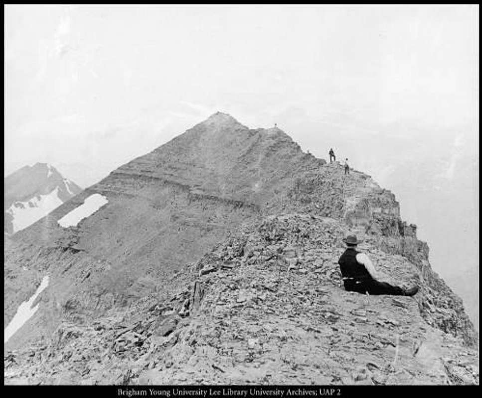
Awesome Article

Nice write up Scott. My grandfather has a few pictures of when he climbed it in the 30's or 40's. I should see if I can find them.

Scott

Scott - Jun 18, 2009 11:54 pm - Hasn't voted

Re: Awesome Article

That would be awesome if you could add them.

phatty

phatty - Aug 27, 2009 11:48 am - Hasn't voted

Good Work

Great article! I will be making my 4th summit of Timp in September. Will document some photos and post them for ya!

Sam Dunford - Nov 20, 2013 12:25 pm - Voted 10/10

Crevasse photos

I emailed the Timpanogos Emergency Response Team (TERT) and Glen Meyer sent me some photos of the crevasse. How do I add them to the article?

Scott

Scott - Nov 20, 2013 12:51 pm - Hasn't voted

Re: Crevasse photos

Awesome!

There is an "add image" tab on the left side of the article. It would be great if you could add them!

Sam Dunford - Nov 20, 2013 1:09 pm - Voted 10/10

Re: Crevasse photos

It isn't there.

However, in the images for this article I found a way to add one. Now all you have to do is add it to the article itself.
Here is the link to the image:

http://www.summitpost.org/timpanogos-glacier-crevasse/876737

This article is definitely the definitive work on the Timpanogos Glacier. Without it, me and many other people would never have known that there is a real glacier. Doing more research, I found that there isn't really any information on the Timpanogos Glacier that isn't in this article. I am corresponding with scientists at the U of U about doing more research. Since it is the last glacier in the state of Utah, it certainly deserves more study. I will add the other images I have, too.

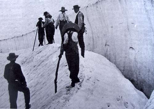
Also, you say "if there is still a glacier buried in the talus" I'm certain there is. If any significant portion of that ice melted, the contours of the talus would change greatly, and they haven't. I also found the same crevasse photo you already have in the BYU photo archives, and it says 1907, not 1908.

Thank you for making this article! I am happy to help by adding the photos!

Viewing: 21-40 of 43

Parents 

Parents

Parents refers to a larger category under which an object falls. For example, theAconcagua mountain page has the 'Aconcagua Group' and the 'Seven Summits' asparents and is a parent itself to many routes, photos, and Trip Reports.