
-
 106 Hits
-
 76.66% Score
-
 7 Votes
|
|
Canyon |
|---|---|
|
|
45.39360°N / 13.99578°E |
|
|
Hiking |
|
|
Spring, Fall |
|
|
Overview
Remark: This could also be considered a route page.
The mountains of Cicarija are characterised by a series of geological faults in the area where the Istrian peninsula is subducting under the Outer Dinarides belt. So, there are many sets of crags and among them lying nice, grassy terraces. As those mountains are built of Cretacious limestones, on many places waters have dug along faults impressive canyons.
The 7 Waterfalls Trail is a round tour, connecting nice waterfalls on Mirna river and its right tributary Draga. Both canyons are deep, but Mirna's canyon is not so wild, lying already on the very border between limestone and flysch. The canyon of Draga is much more narrow and wilder. In both there are also many crags, arranged for sports climbing.
Geographic Outline
Just SE of Buzet town the Mirna river exits its upper canyon, through which it flows in the typical Dinaric direction - from the SE towards the NW. One section of our trail follows it from the Buzet suburbs to the small, very picturesque village of Kotli (the name means: Cauldrons). Draga creek joins Mirna from the right just before Buzet. Our trail follows it up till below the village of Selca. From there, the connection trail to Kotli goes over a plateau-like landscape.
Some Basic Data
Distance: 11.6 km. Some short sections to waterfalls you will do twice.
Lowest point: 58 m above sea level.
Highest point: 271 m above sea level.
Altitude difference: Altogether you will do good 350 m of altitude differences - due to some ups and downs.
Time needed: 4 hours would be the net walking time. But sightseeing will require at least 2 hours more (not taking into account swimming, lunch etc.).
Orientation: The trail is red-blue marked, but not too abundantly.
Season: spring or fall - make sure that you come after a longer rain period, so that waterfalls are strong.
Time of day: Generally, light in canyons is better in afternoon. That's also how you can decide on the direction - CW or CCW.
Hiking difficulty: One section can be graded on the Swiss Hiking Scale with T3 (medium demanding). The rest is easy - T2 and T1.
Maps: Any online map can do fine, for example OpenStreetMap. To avoid other paths, see my interactive map below.
Highlights
You may find many other interesting natural features, but the main are the following (going from Buzet in the CCW direction):
- Mirna upper canyon - nice valley, forested, but with some crags and steep slopes.
- Podkučka vala - fine meadow in the lower part of canyon, below the Kuk mountain.
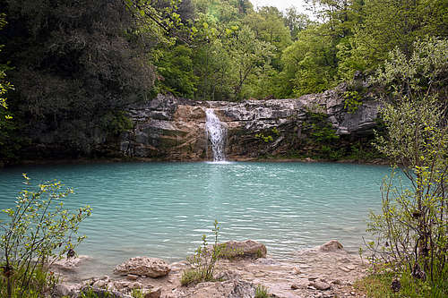
- Grjok waterfall - not very tall, but nice, with a big pond below.
- Zelenščak waterfall.
- Kotli waterfall.
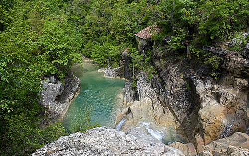
- Kotli river bed - picturesque cauldrons, formed in limestone by flowing river.
- Kotli old watermill - one of the most spectacular watermills far around, but unfortunately in disrepair.
- Kotli village - once more than 100 people lived there, now there's only 1. Some houses are in ruins, others are nicely repaired.
- Napoleon's bridge - not exactly made by the emperor, but still from those times.
- Vineyards and meadows near Selca village.
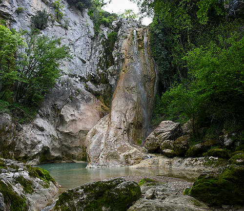
- Mala peč (=Small Crag) - nice, a bit mystical corner with a small waterfall.
- Vela peč promontory - a fine view towards Buzet and nearby crags.
- Vela peč (=Big Crag) waterfall - the tallest one, falling over a huge tufa pillar.
- Draga canyon - some vertical cliffs on both sides, arranged for sports climbing.
- Bačva waterfall - the most modest of all.
- Zagon waterfall.
- Tombasin source - an intermittent karst source near Buzet.
Getting There
You'll probably reach trail heads from the Buzet town. There are 3 convenient points of departure (see the interactive map below):
- Parkings along Mirna, SE of Buzet (45.395275047940856, 13.987849863043568).
- Parking above Selca village (or also a bit below the village), (45.397211879020794, 13.997491555980337).
- Parking in Kotli village (45.3681703336549, 14.017639806290784).
Route Description


Starting SE of Buzet and going in the counter clockwise direction, you first follow a cart-road along the left (western) bank of Mirna. Then you cross the river two times and continue uphills towards the Pengary hamlet. But before reaching it, you deter left - down to the river again. Next three crossings of Mirna are on places where there is no bridge - by rocks, or, if high water, you may need to wade. By a chapel on the nice meadow cart-road gets weaker. We soon leave it, following the path along Mirna's right bank. At the Grjok waterfall we must turn back and after good 500 m we take again the rugged cart-road to the right. Passing above the waterfall, the cart-road turns into a good path, continuing towards the SE. When you hear the next waterfall, Zelenščak, get down to the river bed and explore it. Also some 200 m higher the river bed is wonderful - in a form of limestone cauldrons. Then you continue through the woods by the path which goes quite away from the river. When reaching Kotli, you may want to go steeply down to the old watermill ruins.
At the bridge in Kotli village, descend by the river bed as far as you can - there's the best view on the old watermill! Then explore the village as well and perhaps visit the restaurant.

From Kotli you continue by the cart-road towards the north. Be careful there and try to follow the red-blue marks or consult the map often enough, because there are many paths and cart-roads. After passing the highest point on the plateau, the trail starts descending towards the Draga creek (on some maps also named Pivka). Finally you reach the creek which hardly has any water and cross it by the picturesque Napoleon bridge. Then continue more towards the NW, the path soon turns into a cart-road and you reach Selca.

Before the village make sure to turn left down, following the marks (and an arrow). In a steep descent you reach the Draga creek again. There's a crossroads, and if you want to see the Mala peč (crag, waterfall), you must go left, towards the SE. After exploring it, you return to the crossroads and continue down along the creek. But only good 100 metres. There the marks of the 7 Waterfalls Trail cross the creek. Towards the west you ascend by a broad, rugged path and reach another crossroads. The sign left indicates a path around the hill and down to the Grjok waterfall, but we must turn right - we must see also the remaining 3 waterfalls on the Draga creek. So, we go north on a nice promontory and from it steeply down, following the inscription for Vela peč (Big Crag).

The trail down into the Draga canyon is very steep, almost all the time secured with pegs and ropes. But in some sections they may be also missing, so descend carefully, especially if terrain is slippery. Getting down, you turn right till below the big waterfall and the climbing area. Then you return and follow a good, easy path down the canyon. There are more climbing crags, some caves and the last two waterfalls. When exiting the canyon you only need to visit the Tombasin source and if you parked car on the other side, cross the Mirna river.